

EastonSN+
-
Posts
6,846 -
Joined
-
Last visited
Content Type
Profiles
Blogs
Forums
American Weather
Media Demo
Store
Gallery
Posts posted by EastonSN+
-
-
19 minutes ago, bluewave said:
We have had a Virginia winter temperature regime in place since the +13.3 December 2015. NYC has been at a new winter average of 38.5° lasting almost an entire decade. The previous 1981-2010 winter average was 35.1° So that is +3.4 warmer over a 9 winter period. Plus this is a regional event for the Northeast and many other sites have made a shift like this in December 2015. I am not aware of any other region of the country that has ever had nearly a decade at +3.4° above the previous 30 year climate normals. It’s seems like the frequent marine heatwaves in the Eastern IO to WPAC have loaded the dice for more forcing in these regions which is warm for us. I don’t really know what it would take to shift this pattern.
Monthly Mean Avg Temperature for NY CITY CENTRAL PARK, NY
Click column heading to sort ascending, click again to sort descending.YearDecJanFebSeasonMean 41.0 35.7 38.8 38.5 2023-2024 44.6 37.0 39.4 40.4 2022-2023 38.5 43.5 41.1 41.0 2021-2022 43.8 30.3 37.3 37.1 2020-2021 39.2 34.8 34.2 36.1 2019-2020 38.3 39.1 40.1 39.2 2018-2019 40.1 32.5 36.2 36.3 2017-2018 35.0 31.7 42.0 36.1 2016-2017 38.3 38.0 41.6 39.3 2015-2016 50.8 34.5 37.7 41.0 Western IO temps are rising fast which could create longer/stronger forcing in phases 1 and 2.
-
46 minutes ago, LibertyBell said:
funny it recurred at a 20 year interval, although you could say 03/04 was similar to it.
so a 10 year recurrence?
I honestly do not remember the temp profile of 03/04.
-
-
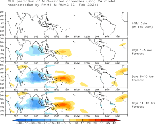
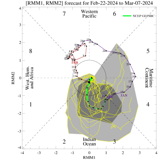
Looking at the MJO, looks like a pretty high amplitude wave in phases 2 and 3. Hopefully moved on so we finally have a warm April.
-
 1
1
-
-
10 minutes ago, kat5hurricane said:
The SSTs will also fuel bigger storms so while winters will warm, we should experience more bigger storms. More winters like '05-'06 and '15-'16 and less like '13-'14 and '14-'15. We really need a cooperative pacific for prolonged winter or the real big storms and that just hasn't happened for a long time.
Eventually the warmer climate will likely be so overwhelming that relatively snowless winters will be the norm but I don't think that'll happen in our lifetime. A snowy period will occur again.
Agree 100%.
I look at 13/14 as a shorter duration, higher snowfall slightly warmer version of 93/94. The next time we have a similar setup we will likely compare to 13/14 and see the same differences.
-
25 minutes ago, LibertyBell said:
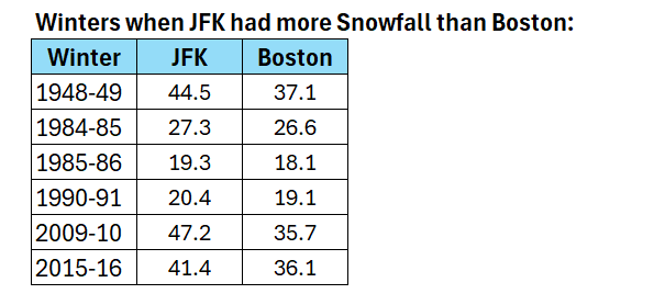
how come the years cant be seen in these tables?
Here is the location
-
 1
1
-
-
1 hour ago, MJO812 said:
Unheard of with snow in the teens
3-5 Inch snow band in NYC
Blizzard of 96 also had this (heavy snow in the teens).
This was one my my 3 lifetime 20 plus events.
1996 - 27 inches.
2013 - 22 inches.
2006 - 20.5 inches.
-
51 minutes ago, MJO812 said:
Gefs and other models were showing the AO tanking for a while. It went negative but never tanked.
Big failure

One thing I always do is look at the previous dips in the presented period. It had not dipped below that threshold.
Perhaps the predicted SSW never materialized or coupled like it was expected to.
-
1
-
-
4 minutes ago, bluewave said:
It think it may be related to these more frequent south based blocks in recent years not having the same staying power as the older ones which where located closer to the Arctic.

I remember someone posted that there is a difference between a true NAO block and an "atmospheric furnace" resulting from an RNA pattern. Basically bootleg.
-
9 minutes ago, brooklynwx99 said:
look at the decade before with the 33.2" average and you can see why we likely regress to under the ~29" 30-year average this decade
100 percent agree. The same happened after the 55 through 69 epic period, which lead to the 30 year period where CPK only exceeded average 4 times (which is mind boggling when thinking about it - 4 above average snowfall winters in 30 years).
I am personally going to compare this decade to the 1980s, which averaged 19.74.
-
1
-
-
40 minutes ago, Brian5671 said:
We are lucky-given that we've had about 2-3 weeks of actual winter 15 inches of snow is a miracle...other dogs like 01-02 or 11-12, 19-20 had low single digit totals
Believe it or not our area was above 10 inches in 11/12 (when you factor in the October snowstorm). 11.5 was my total.
-
I know it's not completely over, however it's not look great for more snowfall.
That would put this decade at 3 below average snowfall winters, only better than last years total. Average this decade before this winter was 19.6 and will take a hit when this year is ultimately added.
-
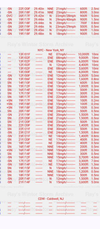
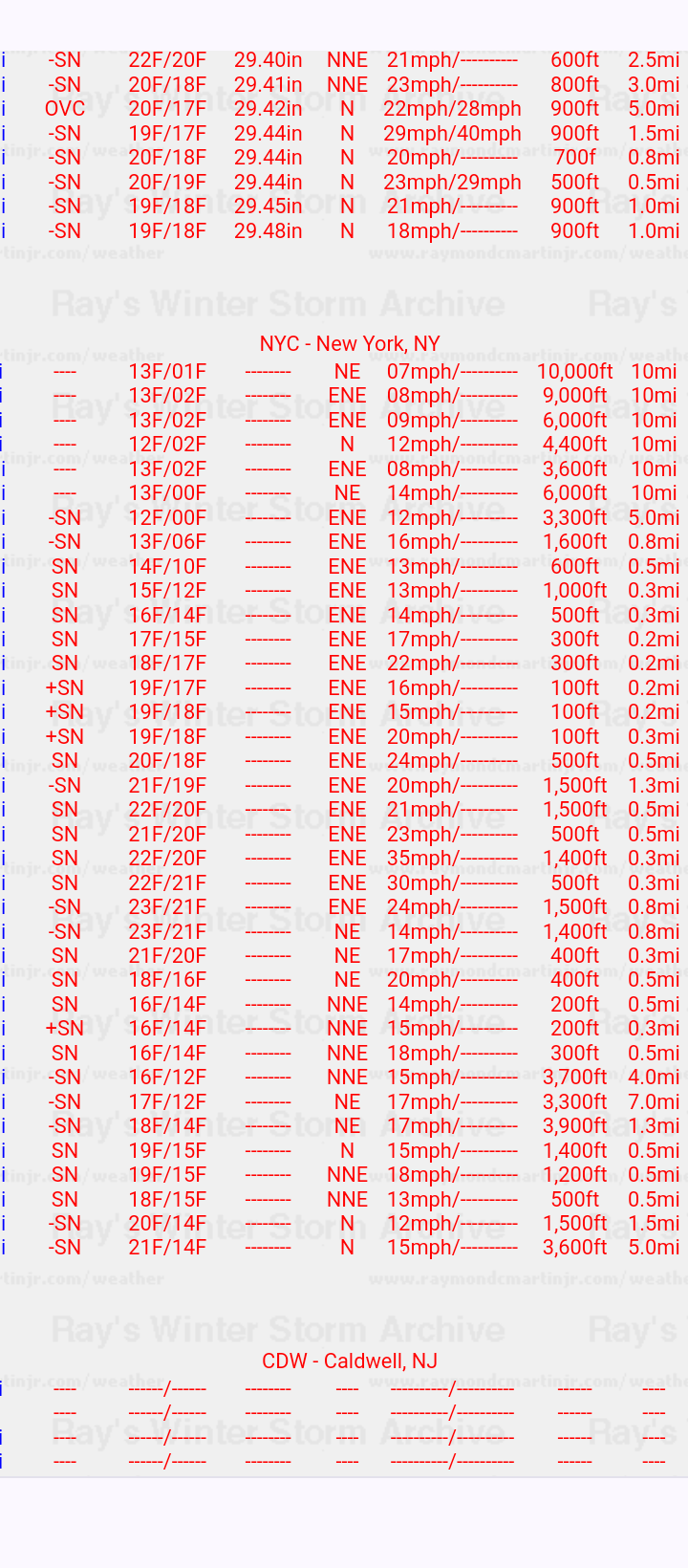
Check these temps out from the blizzard of 96. Wow. Courtesy of Rays winter Storm archive (I really wish it was still being updated).
-
4
-
1
-
-
3 hours ago, bluewave said:
It makes sense that the more southern areas have lost the most snow since they have passed warming thresholds faster for snowfall accumulation. The 50 year trend really shows what an outlier the 2010s was for the Northeast snowfall. So the seasonal snowfall declines have finally made it to our area with the record warmth during the 2020s.
What I find interesting is the fact that both coasts are the only locations to increase snowfall - even down to coastal North Carolina!!
I may be over simplifying, however, this must be due to higher moisture and proximity to events which are continually increasing in intensity.
-
47 minutes ago, donsutherland1 said:
The background warming is part of the longer term evolution of seasonal snowfall. Even there, there will continue to be some snowy winters.
Bad tracks and sustained warmth have all contributed to this year's outcome. Had the intense snow band from Saturday been 30-40 miles farther north, the current seasonal total would probably be around 15"-20".
Thank Don. Also, during the larger storm the intense banding just missed CPK, a little west and perhaps up to 25 inches.
I agree with you on how warming is affecting our snowfall. I do not think we hit a snow wall after 2018 and we will struggle to hit 50% of current average moving forward, but rather a slow steady decline as a backdrop to normal cyclical patters.
I am not as aggressive as you are however, as I believe the decline will be relatively slow due to volatility/potential for historic events. An example would be if NYC is the new Philly from 1996, where Philly was closer to the moisture and received over 30 inches during the blizzard while NYC started with virga due to the temps in the teens at the start and low dew points (resulting in 20.5 I believe). Our latitude and closer proximity to the water would fuel such extreme events similar to 2016.
I do have a question, if we were to have a repeat of 70 through 85, which was at times extremely cold and suppressed, wouldn't we see an increase of snowfall due to higher fees and less suppression from the PV? Just contemplating.
-
19 minutes ago, CPcantmeasuresnow said:
Not as big as you might think.
This decade, as lousy as it's been so far, will be replacing 1991-2000 which only averaged 25.3 inches. The current 30 year average, 1991-2020, in the Park is 29.8. Replace that 25.3 with a 26 average 2021-2030 and their over 30 inches for average in 2001-2030. There's a long way to go.
Of course it would help a lot if they could ever get their sh!t together at the NWS regarding measurements at the Park. It's a long history of under measuring as most of us know, but the last 3-4 years has been especially horrendous.
The 80s only averaged 19.74, which is crazy to think about.
-
1
-
-
11 minutes ago, RCNYILWX said:
From what I've been told by a former coworker at OKX, the CPK conservancy folks do a better job than the security guards that used to do it. But they're still not trained observers like FAA contract observers and probably still lower quality than good long-running COOP sites and diligent CoCoRaHS observers.
If I were to guess, they too often or mostly adhere only to the 6-hour board clearing and don't take intermediate measurements when the situation (melting and/or sublimation of fallen snow) requires it.
That's the only complaint, number of intermittent measurements. It's not always important but is on occasion, especially in small snowfall events.
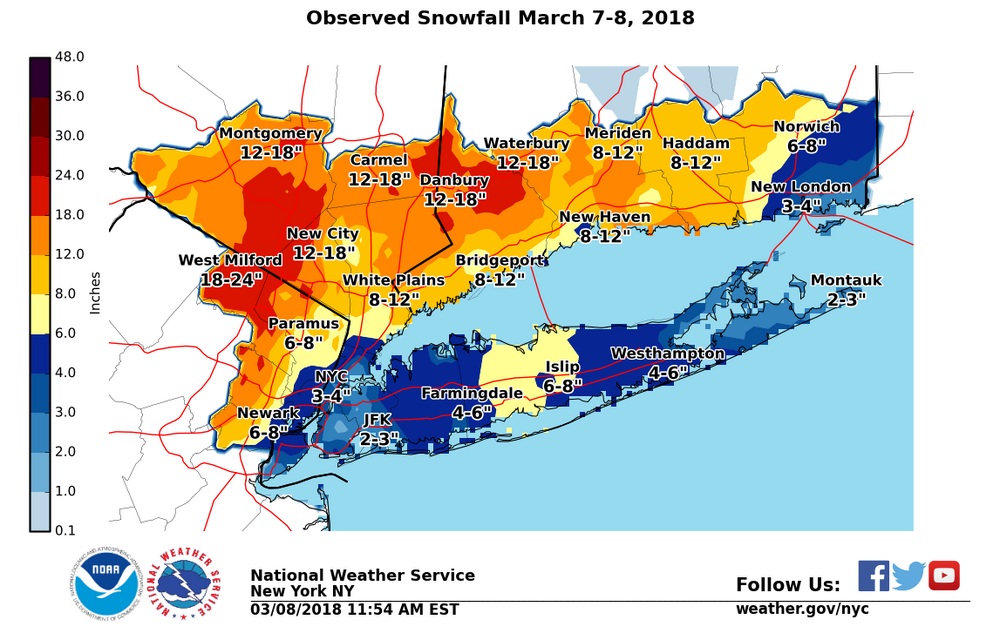
An extreme event IMBY was early March 2018. All day it snowed and due to the temperature being at 34/35, I was stuck at approx 3 inches. Then late night it became extremely heavy, I walked outside not expecting much and was shocked to see a wall of snow, measured a bit over 10 inches! The snow became only moderate and in 2 hours I was down to 7.5 inches!! Temps jumped back to 35.
A few hours later in the morning it was a sloppy 5.
-
1
-
-
Just now, Great Snow 1717 said:
Well here in NE Mass I am sitting at less than 50 percent of normal snowfall to go along with well above normal temps...grade F- winter....
Definitely worse north. I think DC is still above or close to average for this date!
I only grade on snowfall.
-
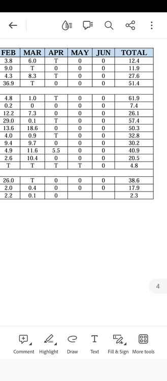
13 minutes ago, donsutherland1 said:
It's actually happened a number of times.
Thanks Don.
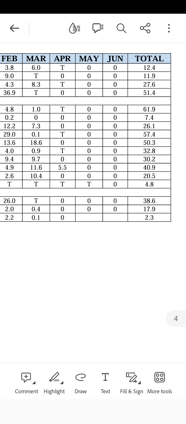
Here is a snip of this decade so far for CPK. Our average is going to take a big hit.
-
1
-
-
1 hour ago, forkyfork said:
i was in piscataway last night and yards that got sun were down to about 3"
Yeah fluff bombs do not have much staying power. We need another March 2017 with heavy snow followed by thundersleet.
-
Just now, Great Snow 1717 said:

Even if it ended today, for myself personally, I have reached 50% of average annual snowfall at 15.5.
I went in honestly thinking 97/98 was possible, so from an expectations perspective I am ok.
-
1
-
1
-
-
2 minutes ago, Allsnow said:
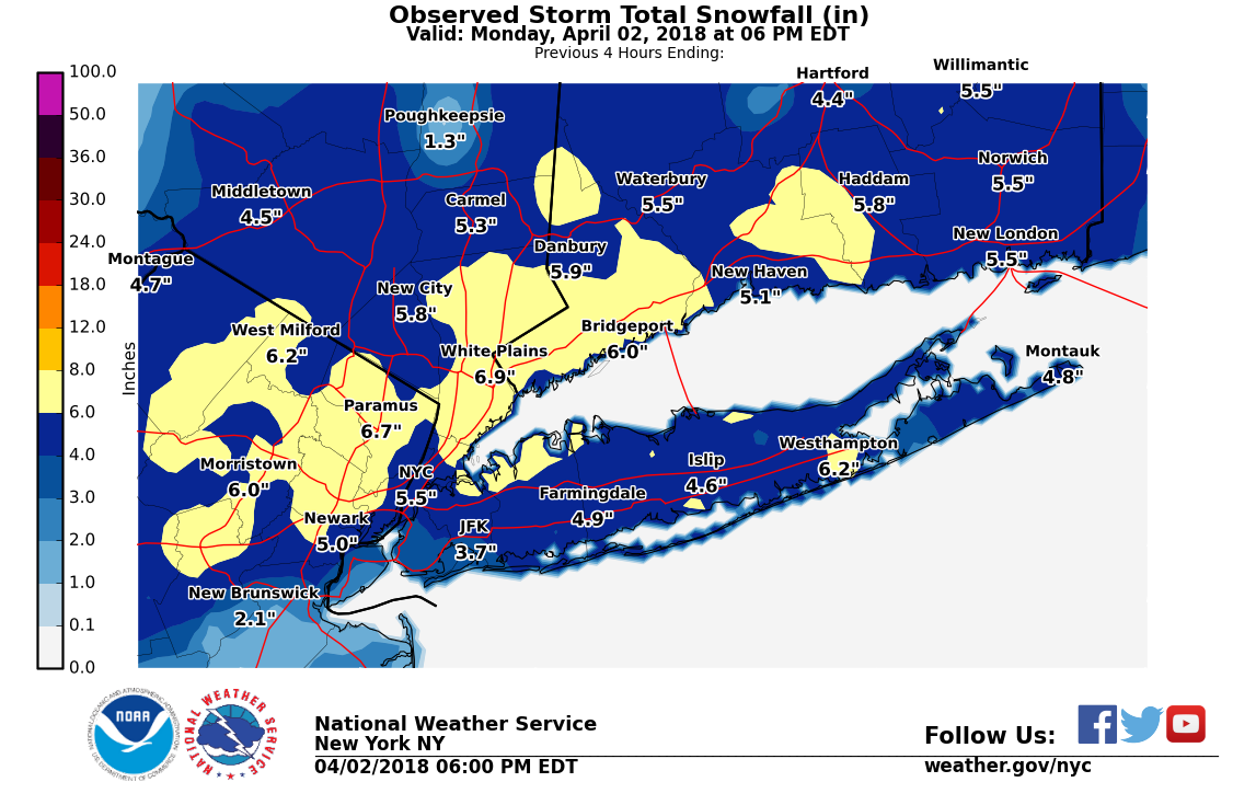
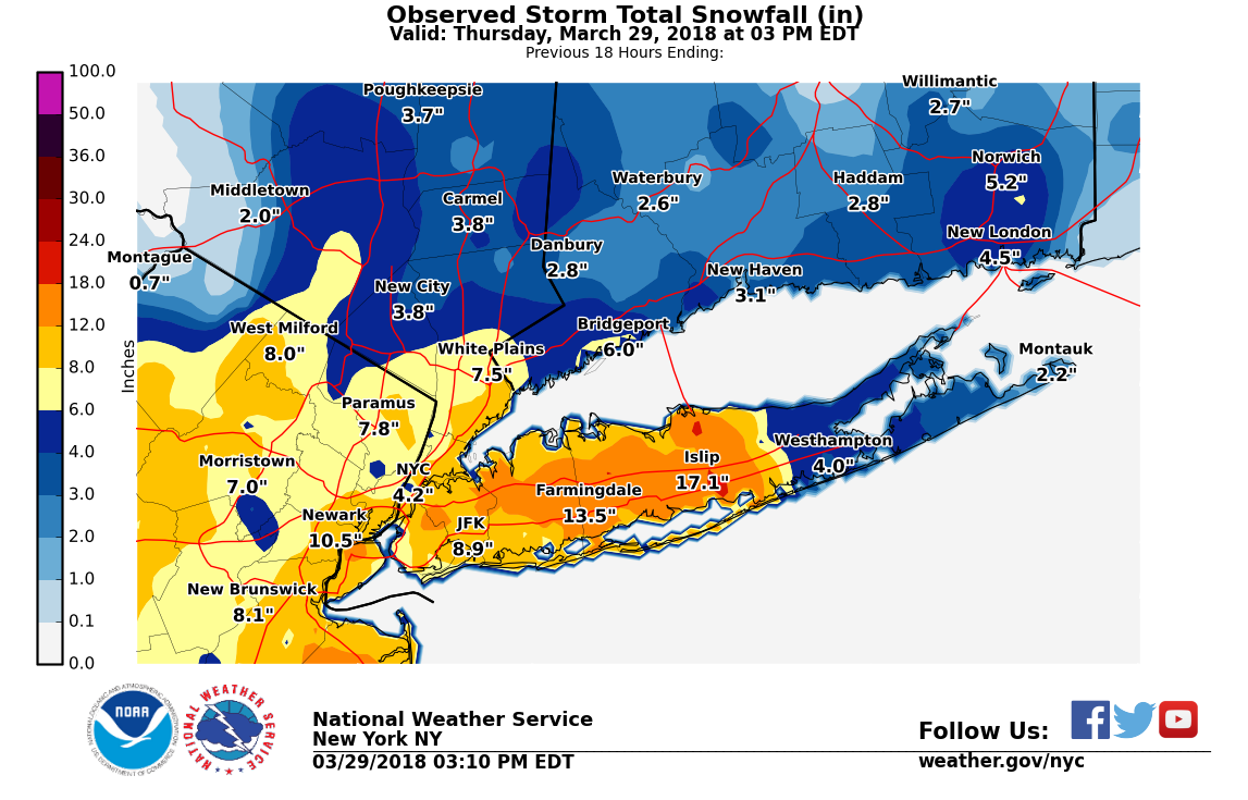
All fluff…reminds me of the last storm in the epic March 2018 run


-
Will be late in the game, however still a possibility.
-
2
-
-
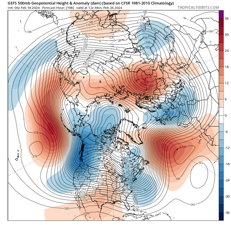
Looking like the change to a warmer pattern is still on track for the 26th.
-
 1
1
-


February 2024
in New York City Metro
Posted
This will likely be Central Park's 3rd below average snowfall winter in a row.
The longest streak I could find was 10 consecutive years from 84/85 to 92/93. Most recent 96/97 through 99/00 (4 years).