

goldman75
-
Posts
263 -
Joined
-
Last visited
Content Type
Profiles
Blogs
Forums
American Weather
Media Demo
Store
Gallery
Posts posted by goldman75
-
-
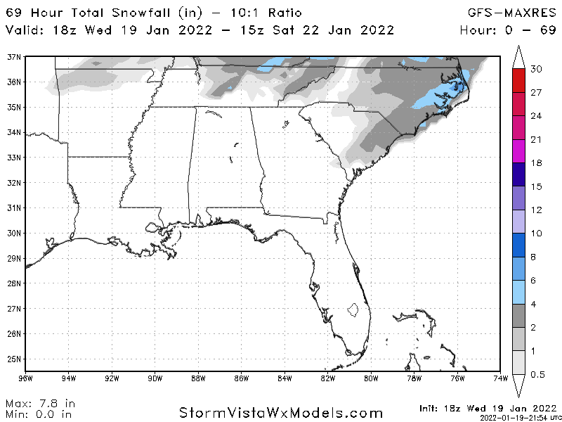
Here in Myrtle beach it looks like we still have a shot at a dusting. That’s all I’m asking for. No snow for years now. My boys would love to just make a snowball lol
-
 2
2
-
-
I work in an emergency room so I had to drive to work tonight. I live in Myrtle beach. Car has icicles on it already. Suppose to be driving home at 7am. Not sure how that’s gonna go
-
2
-
 1
1
-
-
I love the gfs right where it is for us coastal folks. It already has my boys out of school on Friday here in Myrtle beach lol. Can you believe they want them to do virtual school on a snow day? I’ll just say we lost power. Good chance we do anyways
-
Just now, burgertime said:
Congrats outerbanks!
Here in Myrtle beach I’ll take that all day long over all freezing rain!
-
1
-
-
If it’s snowing in tampa then here in Myrtle beach might do ok
-
1
-
 7
7
-
-
What is this possible pivot you guys are talking about? Is it something similar to a hurricane wobble? This pivot is suppose to help snow out east? Thanks for any clarification
")
-
It’s been 779 days since the last flake fell in myrtle beach. HRRR looks like I’m gonna be up with the kids hoping to see some flakes falling around 5am. Would be their first time seeing snow that they are old enough to remember, even if it doesn’t stick
-
1
-
-
It also has the snow hole on Myrtle beach but snows in Georgetown. Mark it on the calendars, it’s legit.
-
1
-
-
17 minutes ago, shaggy said:
Not sure temps would be good enough even if we do get the precip to work in on the Monday storm for the coastal plains.
Yeah, I’m as amateur as they come when it comes to knowing what I’m talking about but we would be heavily relying on wetbulb I think. Need some heavy rates of precip to cool off the surface
-
00z Canadian not on shore yet with the Monday system but it made a leap west
-
i see it creeping to the coast, but temps don’t seem low enough. Down my way in Myrtle beach they appear to be 40ish but even toward the outer banks is mid-upper 30s. Any reason to believe if this trends closer, the temps will play along?
-
3 minutes ago, NCSNOW said:
0z Fv3 is better for you orangburgwx. Solid 2 to 3 inches columbia up to GSO and all points east. So all globals look encouraging for day 4 to day 5 event. Under 5 days finally for a little event. Should have good ratios but its a quick hitter. 3 to 5 hr event then serious cold to follow
My fv3 maps aren’t out that far yet. Does the snow make it to the coast?
-
But not bad for everyone. I’d take that here in Myrtle beach
-
1
-
-
32 minutes ago, bess said:
Post a clown map!!!

-
 1
1
-
-
Start the thread boys

-
1
-
2
-
-
Just now, FallsLake said:
Lol..then after the first storm passes and pulls cold air down, a secondary low forms off the coast and provides a nice snow storm for central and eastern NC.
Even gets some snow and ice to the Myrtle beach area. Not expecting anything, but still encouraging to see.
-
78/64 here for Halloween :(
-
Hi 90 low 70 tomorrow here in Myrtle beach. That’s disgusting for October lol. May as well hit up a restaurant on the beach for dinner and attempt to enjoy it I suppose
-
In Myrtle beach atm

-
1
-
1
-
-
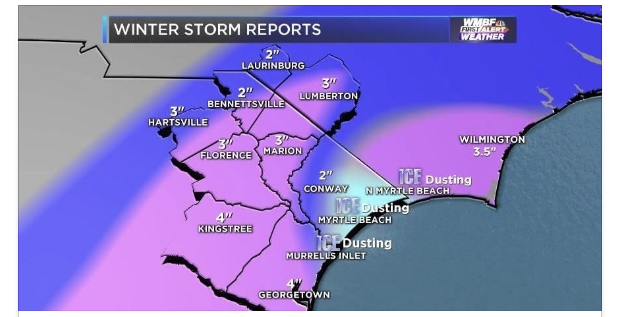
7 hours ago, Snow dog said:
Lol,and you give that a 'D'?? Listen, Myrtle Beach hit their average with a trace this year! I'm afraid you'll need to move north quite a bit, or you'll be disappointed each and every winter down there..
Mostly a D because of the horribly blown forecast. Every met here was even now casting as the storm was in progress saying 4-6 inches. The trace was mostly just sleet. So yeah, the only reason I didn’t say F because of the potential was we did have a good stretch of really cold weather which was nice.
-
And on that note, Myrtle beach will take its D for the winter ( trace snow and good cold ) and call it a season. On to the severe weather!
-
Back to the drawing board after that bust. A dusting to a half inch they said. Get the sleds out they said. Looks like I’m just eating normal ice cream today
-
1
-
1
-
-
I had a forecast of 3-5 inches like the folks around me got. Guess where I live


-
My local met here in Myrtle beach, ed piatrowski, is very conservative. At 2pm today he released his map and said 3-5 inches of snow. All we got is a handful of sleet pellets. What a bust so far. Maybe we can squeak out an inch if it changes over eventually

Mid to Long Range Discussion ~ 2024
in Southeastern States
Posted
lol just wanna see the 0z go one tick further
.