Blizzard of 93
-
Posts
9,963 -
Joined
-
Last visited
Content Type
Profiles
Blogs
Forums
American Weather
Media Demo
Store
Gallery
Everything posted by Blizzard of 93
-
Best Euro run for the LSV for this event since the fantasy range runs several days ago… Good to see at game time.
-
18z Euro is in line with other 18z guidance.
-
I think the WGAL-8 call of 2 to 5 is a very reasonable forecast.
-
It’s really nice to see the models juicing up as we approach game time.
-
ABC -27 is really going low with 1 to 3 & said most should end up with 1 or 2….but he’s been “watching it closely”!
-
Same here! Thanks for posting the model run maps today!
-
It’s on the way….the radar is juiced to our southwest.
-
Yes indeed, hopefully you are able to enjoy some of your game later on after your meeting & then jackpot with snow tomorrow, while also tracking the Friday potential!
-
I’ll take the 12z Canadian for 1000 for Friday! This has the chance to be another good duration & high ratio event if the players cooperate as they do on this run. This run has the same look that a couple of GFS & Euro runs have had off & on over the last few days. Snow map is only for the Friday potential.
-
A little better for the LSV than 0z & in line with most guidance.
-
WGAL-8 has 2 to 5 of snow for southern PA for tomorrow.
-
Every model that I have looked at this morning supports the CTP Advisory for the 2 to 4 of snow.
-
Good to wake up to see the Advisory. Hopefully some of us jackpot with this event!
-
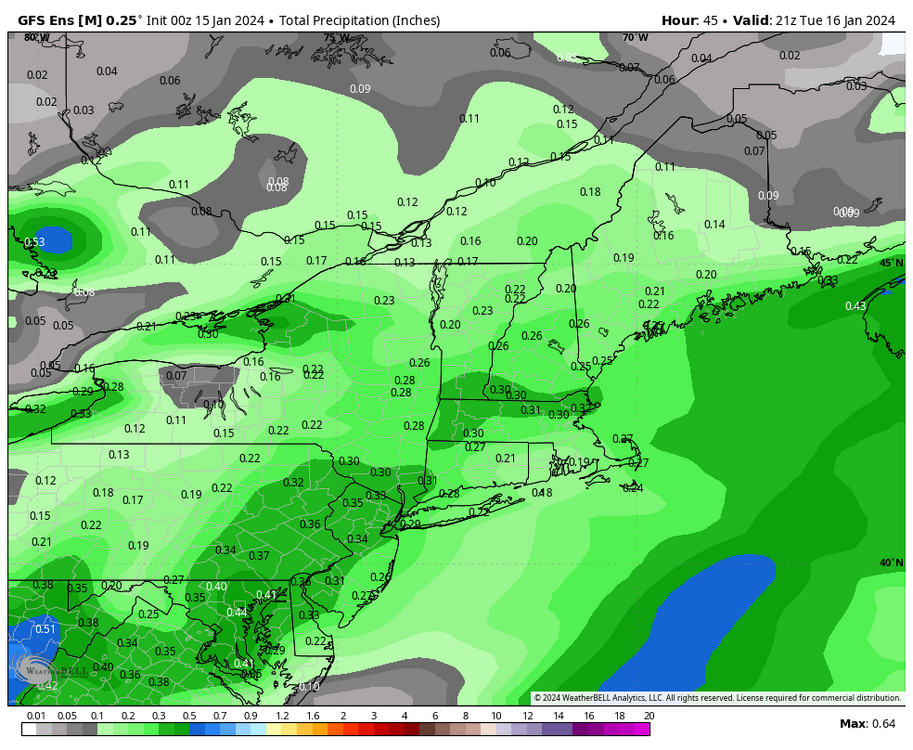
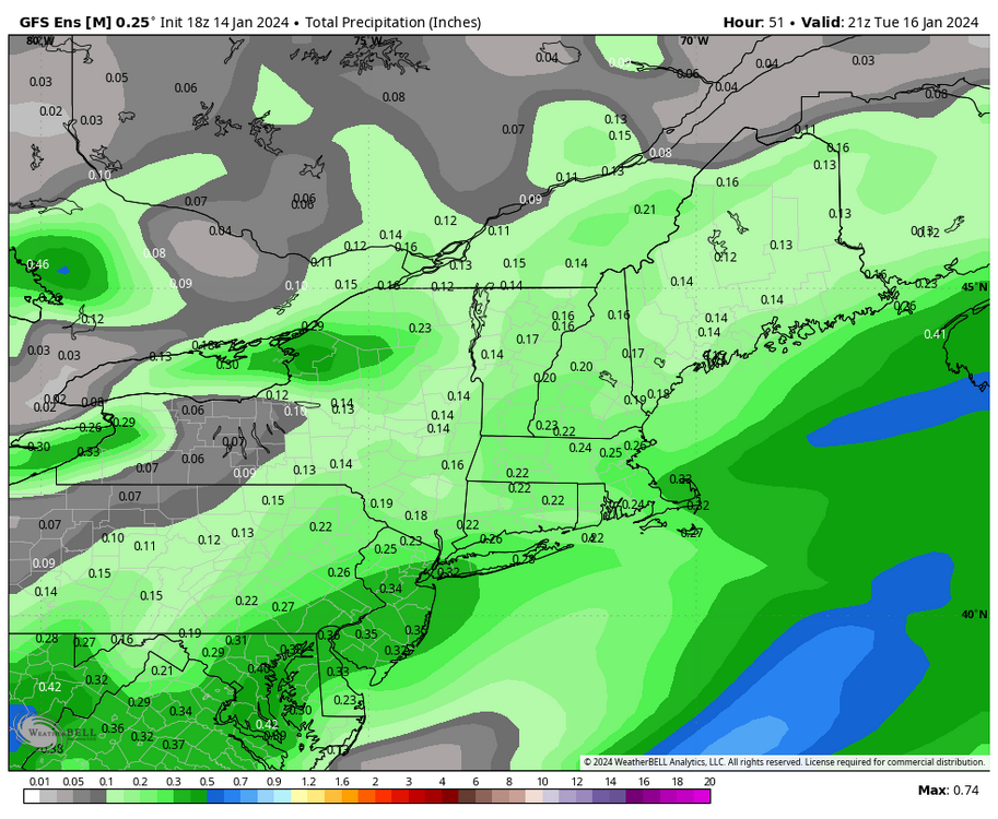
It’s a little late for ensembles, but the 0z GEFS juiced up over 18z a good amount for the LSV. 0z top vs. 18z bottom
-
0z Canadian decent as well
-
0z GFS looks decent for an Advisory level event for most.
-
0z RGEM looks good for a CTP wide 3 to 5 this run.
-
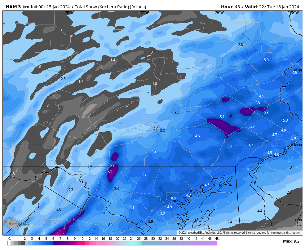
The NAMs are a good hit for the LSV.
-
21z SREF is good for the LSV
-
DT has this gem of a map out for start times tomorrow…. So many lines & colors…
-
Got it, I’m not familiar with them.
-
I like seeing a building area of precip in Kentucky & Tennessee as currently shown on radar that is moving slowly northeast. I agree that most Winters are built on 2 to 4 or 3 to 6 type of events. The double digit events are rare & only happen every few years or so on average. Hopefully, we score twice this week, which could get us back on track for an attempt at reaching our seasonal average snow.
-
Whose forecast is this?
-
This is the type of system that could overachieve with cold air in place & moisture approaching from the south.
-
Good CTP discussion & those ratios are sweet! “Increasing fgen forcing and favorable upper jet dynamics downstream of mid level trough digging through the Ohio Valley and developing low pressure off the East Coast is expected to produce a broad area of light snow across CPA Monday night into Tuesday. Ensemble data shows the highest probs (>50% chance) for 2+ inches over the southeast zones. We have general 1-3"forecast over most of the area, with the lowest amounts over the northern tier where surface ridging and dry air may limit the snowfall. A winter wx advisory may be needed for the lower Susquehanna Valley with 2" of snow. The character of the snow will be dry and fluffy with SLRs mainly in the 15-20:1 range. Light snow is forecast to pull to the northeast Tuesday afternoon and end by Tuesday evening. Another shot of arctic air will invade Tuesday night with min wind chills getting very close to -15F criteria over the Alleghenies. Most places will experience wind chills between 0 and -15F Wednesday morning.”