

Neblizzard
-
Posts
1,091 -
Joined
-
Last visited
Content Type
Profiles
Blogs
Forums
American Weather
Media Demo
Store
Gallery
Posts posted by Neblizzard
-
-
53 minutes ago, Stormlover74 said:
Nam cut way back

Good to see
-
 1
1
-
-
36 minutes ago, Allsnow said:
Nam is only correct when it shows no snow for us…
sigh
Yup and people fall for it time and time again
-
1 hour ago, snowman19 said:
If I had to guess right now, I’d say a general 1-2 inches total for the area Tues-Wed
Coming from you , that’s a blessing . Enjoy your wedding
-
19 minutes ago, North and West said:
Let’s just get through the next ten days before you start getting excited for warmth again. (Not saying you’re wrong, just one thing at a time)
.Agree. Let him and his fiancé enjoy their wedding instead of obsessing about warmth for once.
-
 2
2
-
 1
1
-
-
11 minutes ago, ForestHillWx said:
Nothing like a good old fashioned storm cancel, 5 days out.
That’s why you can’t even trust models 24 hours in. I’ve learned my lesson
-
 1
1
-
-
1 hour ago, SnowGoose69 said:
I would not even describe those as Nina...those long range ensembles would be torches everywhere...they are both 01-02/11-12 like minus the brief periods in those winters where we saw SERs...there's a ridge in W Canada and trof in the east as far as mean heights but there would be no cold aie.
The pattern is nothing like a La Niña . The subtropical jet is strong and the northern branch is way up in Canada . This is a classic strong El Niño close to 97-98
-
13 minutes ago, Allsnow said:
0.29
Radar looks spotty with best rains well west
Calling bust already ?
-
2
-
1
-
-
4 minutes ago, suzook said:
As of yesterday, you would have thought winter was over. Today, we get a cold run from the cmc, and slightly colder run from gfs, and winter is back. Its hilarious. Give me 3 days of solid runs showing cold, and I will buy it. I seriously don't think we see real cold/snow until Jan. I'm ok with that, as Jan and Feb, hell even March is when we get snow on LI.
Watch what you say on here this year. Lot of sensitive warminstas.
6 minutes ago, suzook said:As of yesterday, you would have thought winter was over. Today, we get a cold run from the cmc, and slightly colder run from gfs, and winter is back. Its hilarious. Give me 3 days of solid runs showing cold, and I will buy it. I seriously don't think we see real cold/snow until Jan. I'm ok with that, as Jan and Feb, hell even March is when we get snow on LI.
Watch what you post on here . They’ll say it’s over before it’s even begun.
-
2
-
 1
1
-
1
-
-
48 minutes ago, Allsnow said:
Not a good sign for the typical back loaded Nino winter response
It’s not I must admit. Come back next winter.
-
1
-
2
-
-
January 4th
-
1
-
-
10 minutes ago, bluewave said:
There really isn’t much in the way of cold air near the coast even If a more amped pattern verifies since it’s all Pacific air getting stuck under the block.


We may have to wait until late December for better El Niño forcing and favorable MJO progression
-
1
-
-
4 minutes ago, Rtd208 said:
IMO this is basically done for areas west of the Hudson with msybe the exception of extreme NE NJ. We'll see.
It’s been done for hours ..
-
2
-
2
-
-
6 minutes ago, EWRNJ said:

Looks like some echos showing up again over Jersey
.Areas west of I-95 are the question mark
-
Here in Union County NJ, we dodged the bullet. I’ve been flooded out from Irene and IDA came darn close. This would have been catastrophic for my area had this been 25 miles west.
-
1
-
-
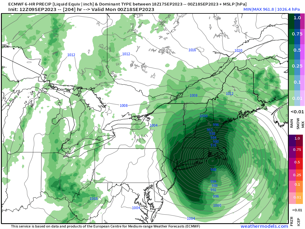
The 12z NAM focuses the heaviest rain from NYC up thru Northern NJ and the Hudson Valley.
-
20 minutes ago, BxEngine said:
Best call of the thread…
Amounts ranging from 1-5 inches across the metro. Indeed his call was the best …
-
5 minutes ago, NJwx85 said:
12z RGEM

If this trend continues the NYC metro will have to worry about severe weather
-
1
-
-
10 minutes ago, Brian5671 said:
If so, it's really slow-other models have the low well north or east by Monday AM
It’s more west than yesterday
-
5 minutes ago, MJO812 said:
Eps vs the world
That was a big shift west
You have the maps?
-
24 minutes ago, CheeselandSkies said:
Every weather forum on the Internet would like to thank the 12Z Euro for the weenie run that was desperately needed to revive interest in Lee.
If verified that’s a Bob redux
-
1 hour ago, Allsnow said:
That hurricane next week is for the fish. All the hype is click bait
Most Mets and others have agreed this would be a fish storm. I don’t see any hype about an east coast strike
-
2
-
-
2 hours ago, snowman19 said:
Great post. Yea the RMM plots are chaos right now but we are seeing a phase 4-6 progression through early December. Looks like we go RNA/-PNA by early December which isn’t a surprise given the Niña/PDO/PMM background states
The models can’t even get a pattern right within 3-5 days , do you buy everything they say when they show a breakdown ?
-
4
-
1
-
-
18 minutes ago, SnoSki14 said:
Did he even look at the MJO forecasts. Majority show the MJO going to 7-1
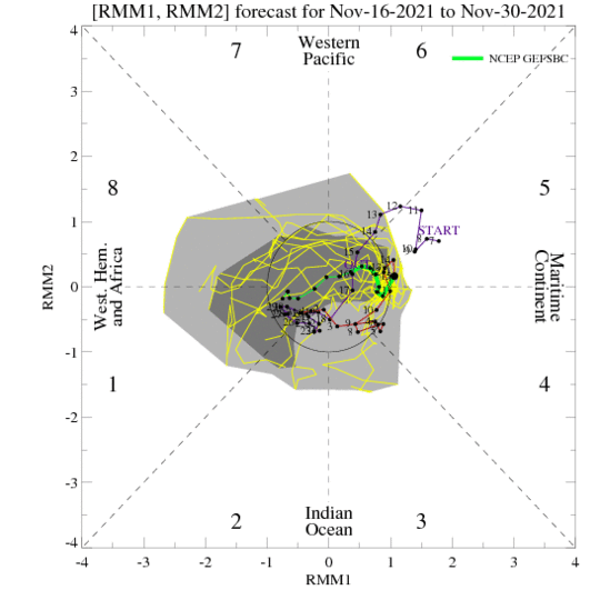
He never does. The La Niña has basically peaked and is becoming more east based. That could lead to a stronger MJO down the road . Just what you want to see…
-
2
-
1
-
-
2 hours ago, WarrenCtyWx said:
Imagine a cold winter with below average snowfall. That would be the most shocking outcome.
85-86 is an example


March 2024
in New York City Metro
Posted
Good give you credit where it’s due, you did good this winter. Congrats.