

CT Valley Snowman
-
Posts
4,680 -
Joined
-
Last visited
Content Type
Profiles
Blogs
Forums
American Weather
Media Demo
Store
Gallery
Posts posted by CT Valley Snowman
-
-
Pretty cool experience. Noticeably cooler and dimmer even outside of totality, which must have been amazing to witness.
-
Getting some minor sleet accumulations on colder surfaces here. A mix of sleet and rain continues.
-
Mostly sunny and 65 here. Gorgeous day.
-
 1
1
-
-
33 minutes ago, The 4 Seasons said:
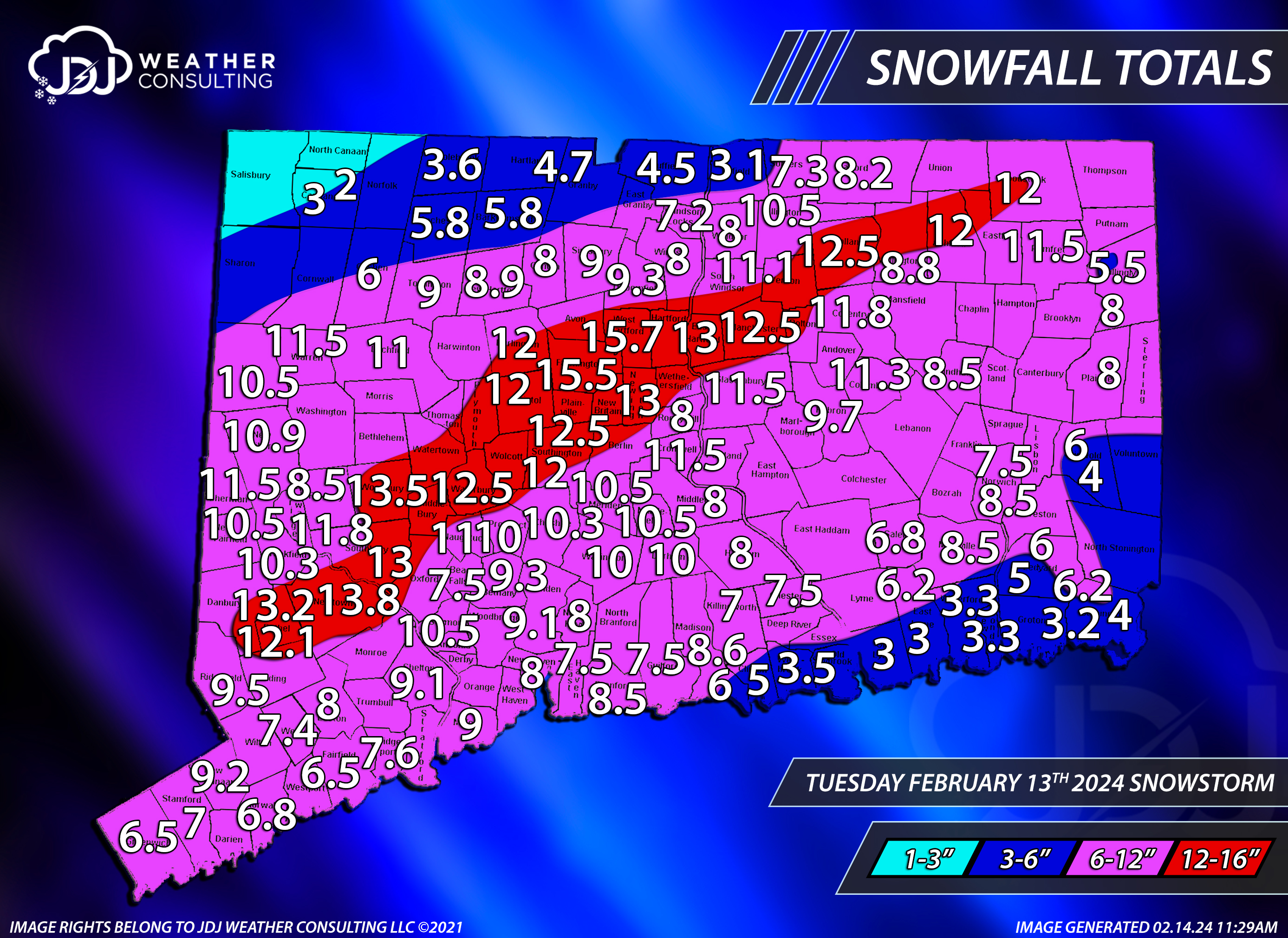
Here's the update i promised yesterday. A TON of reports for this one, wow. I even but a little hole over Dayville, Alexander lake i believe it is? Thats the only big lake around there for @Cold Miser
Ill be working on a SNE map today as well and then an updated season to date map for CT and SNE. Dont forget to update the New England Snow page
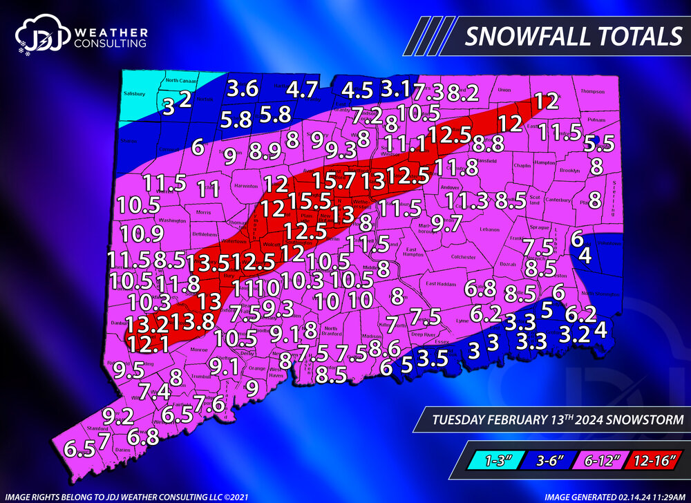
Great map as always but that 3.1" is definitely a bit low over my hood in Enfield. I had 5.75"
-
Measured between 5.5" and 6" here. Lines up nicely with your map as I am north of the center of Enfield where the 6-inch line is. I'll go with 5.75".
-
I missed the meat of the big boy band here but still a nice snowy late night and morning. After the late shifts south i was a bit concerned about this area north of BDL really struggling but that razor sharp cutoff was just north of here.
-
1
-
-
About 3.75". Steady light to moderate accumulating snow here just north of the heavy band.
-
2 minutes ago, DavisStraight said:
I think we get 2-4.
Some of the mesos are pretty paltry, especially further west back this way. Hopefully you're right. Earlier today we were headed to the buffet and now we're just hoping for scraps.
-
Not really feeling good about things up here 2 miles from the mass border in CT. Hopefully those further south cash in with at least a decent period of snow.
-
1
-
-
Still a relatively torchy 39 here in the valley.
-
Box dropped the wind gusts to 38 mph here and 40 for Tolland in their point and clicks for tonight.
-
 1
1
-
-
8" here. 9.8"at BDL. Very solid storm.
-
2
-
-
23 minutes ago, Damage In Tolland said:
Well we’ve lost the paster we were hoping for. Temps running quite a bit colder than modeled . Probably bodes well for those on the line to the south and also tips the cap towards colder solutions.

33.7 here in the valley, we'll get the paste, you'll get better ratios. Hoping we don't get marginal rates with borderline temps and shadow on the east flow and end up with like 4-6". If I honestly had to give a number for here, I'd probably go with 5".
-
Meanwhile 56 here, 57 at BDL and HFD we torch.
-
1
-
-
Berks are roasting on that map. 77 at Pittsfield and 79 at North Adams for 6 hour max temps. Mainly low 70s here in the valley with a 75 at BDL.
-
Low of 32.7 at a nearby PWS. Close bur no cigar.
-
.91 at a nearby PWS. Another wet day.
-
2
-
-
Several nearby PWS are in the 15-16" range for July after yesterday's 3". A drier pattern would be welcomed.
-
1
-
-
Stormy soaker of an afternoon here. Several nearby PWS are between 2.75 and 3.25.
-
2
-
-
13 minutes ago, ineedsnow said:
Any confirmed tornadoes today?
BOX CWA has one confirmed in North Brookfield MA
-
3
-
-
Stormy afternoon here. Several close CTG strikes, heavy rain and some flooded roads.
-
2
-
-
Seeing some flashes of lightning to the NW here.
-
-
3.8 here. Pretty much all of it fell last night. Today has been either dry slot or non accumulating snow. There was a gradient across town based on latitude/ longitude. The further N/W you were the more snow you got. A couple of people reported 5 on the town forum, meanwhile my wife was down on the SE corner of town near Ellington on her way to Manchester this afternoon and said the ground was bare.
Sunday, April 14, 2024 Thunder Thread
in New England
Posted
Congrats PA