

EHoffman
-
Posts
664 -
Joined
-
Last visited
Content Type
Profiles
Blogs
Forums
American Weather
Media Demo
Store
Gallery
Posts posted by EHoffman
-
-
1 hour ago, North Balti Zen said:
Adley HR. And…we’re back.
Burnes looked good too
-
13 hours ago, Harv_poor said:
As I walked around my neighborhood earlier today, I was shocked to see that some of the north facing roofs still had snow on them.
I saw some vestiges of icy snow melting on a lawn in upper NW yesterday, which I thought was crazy.
-
2 hours ago, CAPE said:
Found it. PSU2 storm? It's happening ! this time.

Strong signal for day 31
-
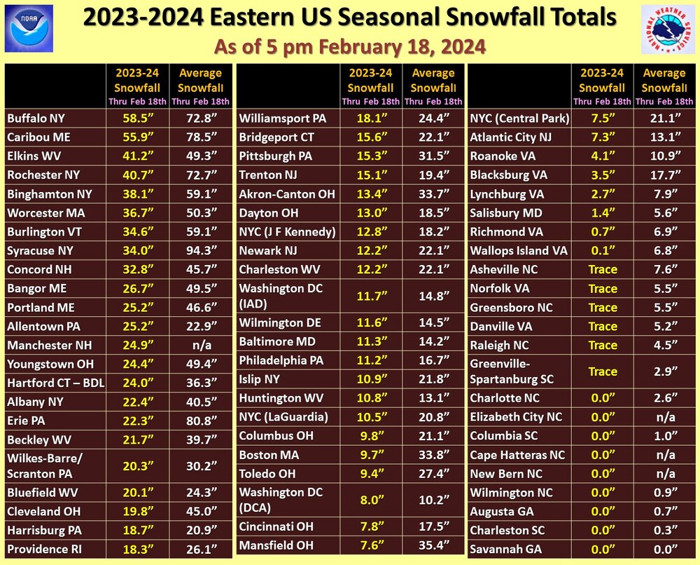
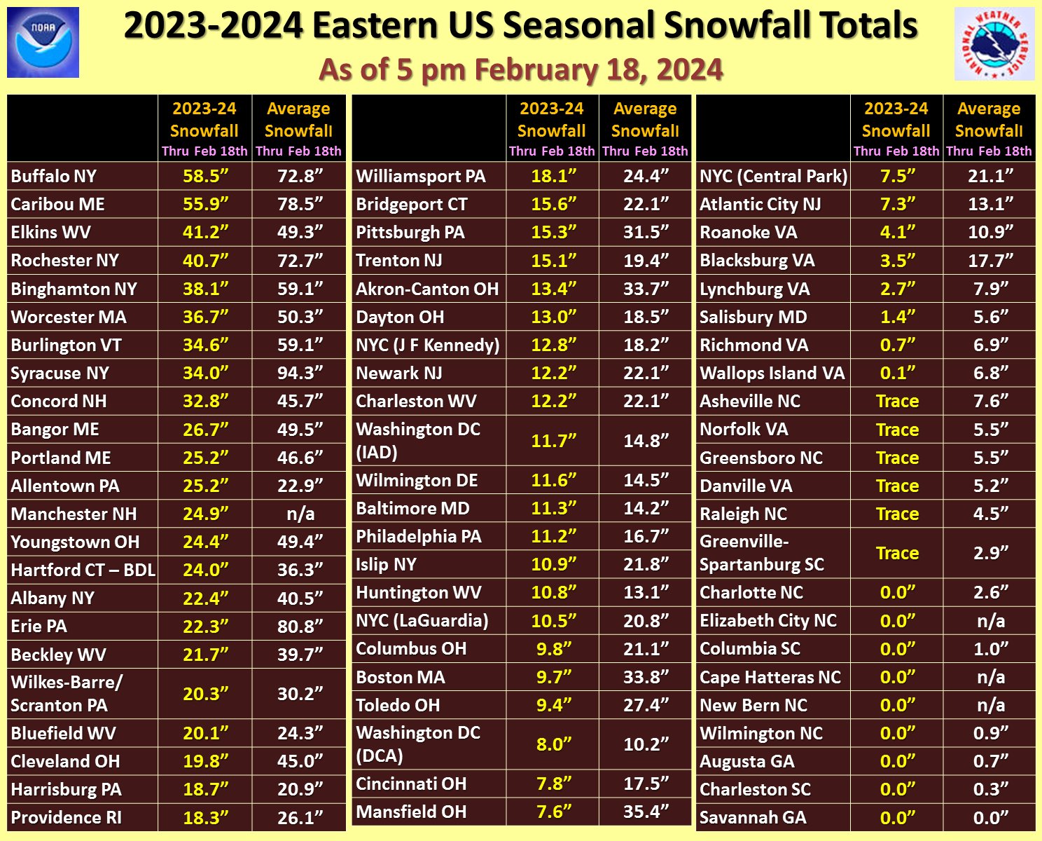
Updated snow totals from NWS Eastern Office tonight. Everywhere but Allentown is below average to date, Syracuse over 60" below average.
-
 1
1
-
 1
1
-
-
I would take a photo of my outside right now but I don't want everyone to get jealous.
-
8 minutes ago, NorthArlington101 said:
Boo. I’m staying up for my hour of snow. Radar looks ok to the west.
Been up watching The Wire for the past few hours, so not a total waste.The game is the game
-
1
-
1
-
-
I don't see any flakes.
-
1 minute ago, jayyy said:
We go down with the GFS!Yeah that's usually how it goes
-
 4
4
-
-
Just now, MN Transplant said:

Sorry that image isn't showing up can you try never posting it again
-
1
-
11
-
-
I feel like we should start another thread for obs since there's only been 1 and we need to satisfy the snow gods' 2 threads per storm requirement
-
2
-
1
-
-
Just now, WEATHER53 said:
Real serious radar returns. Unless it’s moving over 60mph I don’t see a mere 4 hours. Well may be 4 hours of 0.5”+ with 2 hours if 1-2”ph but not started and done in 4
I can already see the backedge though.
-
1
-
 1
1
-
-
6 minutes ago, Miss Pixee said:
For all the DC yappin' gone off the rails...just thought I'd post up this ditty. Bears reminding based on where you are.
"The highest natural elevation in the District is 409 feet (125 m) above sea level at Fort Reno Park in upper northwest Washington. The lowest point is sea level at the Potomac River. The geographic center of Washington is near the intersection of 4th and L Streets NW."
Topographic map below. DC is a combo of appalachian ridge and plains. Like a bowl, edges are high, middle part low. Mt parents and grandparents said the mall was swampy at one time. I saw an old pic of cows grazing on the WH lawn! Crazy stuff. NW is large areas of high elevation. SE is a staircase that keeps going up and most of the streets are hills in all directions. My neighbors can sit on their front porch and see the Cathedral in NW clear as a bell. On Howard road SE you have a clear site line to the monument like its a mile away. Wild.
We now return to your regularly scheduled snow channel...
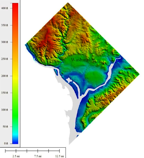
"High elevation" being a relative term...but yeah people forget upper NW is quite hilly. If you go to Fort Reno Park they have a little placeholder for the highest elevation point in dc. It's...underwhelming.
-
Just now, Yeoman said:
In DC I wouldn't either... it will likely be history if you wake up after 9am.
I'm fine with that, I'll be up tonight.
-
I don't even care about accums now, if I don't see thundersnow this storm is a bust
-
1
-
1
-
-
1 minute ago, stormtracker said:
GFS time is near...Will it be drier? Will it be norther? Will it be cold enough?
It's gonna bisect DC with the heavier snow amounts 100%
-
I napped for 3 hours during 2016 and missed our only thundersnow so yeah, I'm staying up.
-
1
-
 1
1
-
-
2 minutes ago, Ji said:
only in this area can we have 850 temps at -6 to -8 and worry about temps
Live by the swamp die by the swamp
-
1
-
-
1 minute ago, stormtracker said:
120 is like 20% ABV
Was never really into those mega Dogfish IPAs
-
13 minutes ago, CAPE said:
@stormtrackerI tried on my way home to grab a 120, but had to 'settle' for a World Wide Stout. Much different beer but same effect with 17% abv.
17% ABV is absolutely insane for a beer
-
1
-
-
Zero hour freakout…this is a dc snowstorm alright
-
1
-
5
-
-
2 minutes ago, pazzo83 said:
yeah there actually is a secondary max just north of Cathedral Commons (right around the new Taco Bamba) that is close to 400'
This is the area where I jebwalk, always seems to outdo AdMo
-
1
-
-
2-4 was always the goal
-
1
-
-
1 minute ago, Ji said:
that TX gulf coast junk was suppose to be PD3
 instead we get a PD 2.214848
Just think, we could all be under warnings right now
-
2
-
-
1 minute ago, midatlanticweather said:
That looks nice for MBY

I'll take one of these please
March Banter 2024
in Mid Atlantic
Posted
Crazy how many semis there are driving through this blizzard. I guess they don't have a choice? Seems wild to me to even attempt it.