

Random Chaos
-
Posts
751 -
Joined
-
Last visited
Content Type
Profiles
Blogs
Forums
American Weather
Media Demo
Store
Gallery
Posts posted by Random Chaos
-
-
Dusting here. Mist of the ground is bare but some locations have snow.
-
2 hours ago, Miss Pixee said:
For all the DC yappin' gone off the rails...just thought I'd post up this ditty. Bears reminding based on where you are.
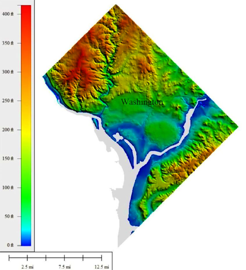
"The highest natural elevation in the District is 409 feet (125 m) above sea level at Fort Reno Park in upper northwest Washington. The lowest point is sea level at the Potomac River. The geographic center of Washington is near the intersection of 4th and L Streets NW."
Topographic map below. DC is a combo of appalachian ridge and plains. Like a bowl, edges are high, middle part low. Mt parents and grandparents said the mall was swampy at one time. I saw an old pic of cows grazing on the WH lawn! Crazy stuff. NW is large areas of high elevation. SE is a staircase that keeps going up and most of the streets are hills in all directions. My neighbors can sit on their front porch and see the Cathedral in NW clear as a bell. On Howard road SE you have a clear site line to the monument like its a mile away. Wild.
We now return to your regularly scheduled snow channel...
If you’re not familiar with Maryland’s lidar map, it includes DC and is awesome: https://geodata.md.gov/topoviewer/
-
 2
2
-
-
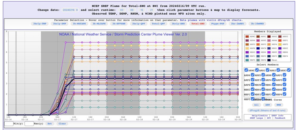
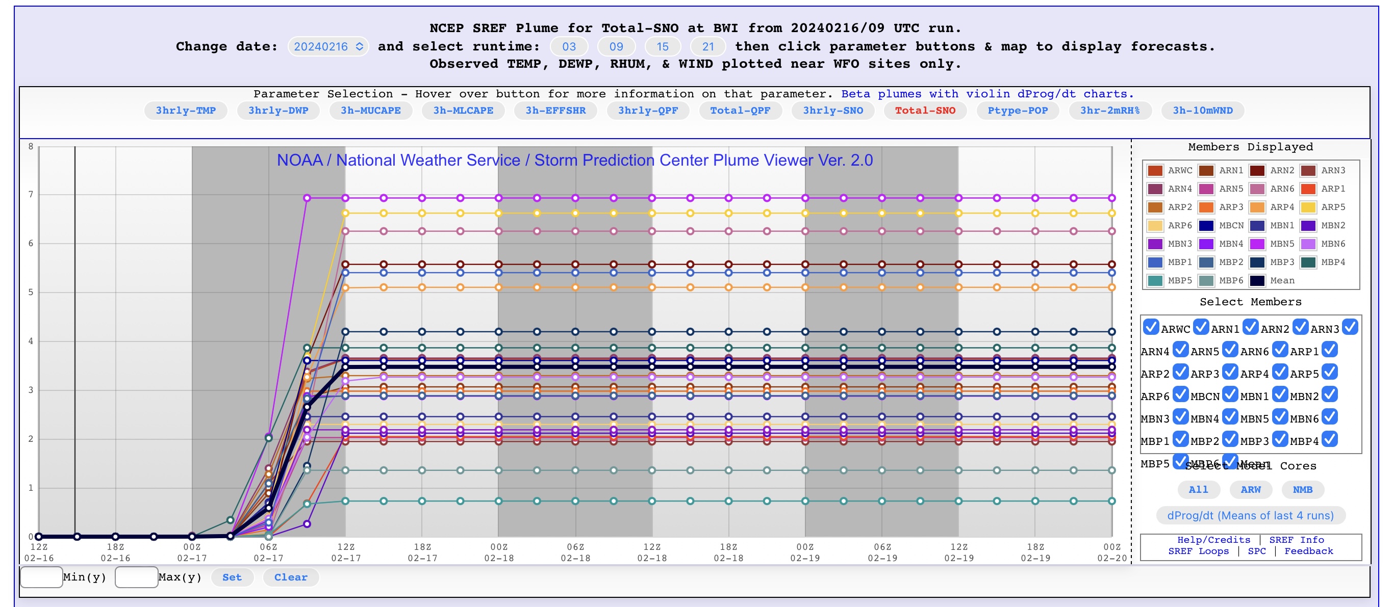
I’m confused on the LWX snow graphics. They list worst case as most snow. Isn’t that best case? Worst case is no snow

-
Don’t think anyone posted this yet…
-
47 minutes ago, stormtracker said:
So, we're not keeping one eye half open about the Sunday thing? It's the longest of long shots, but I mean..there's a high right there. All we need is to thread the needle, and an eclipse or something
*jots down note* Snow on April 8th, 2024 during solar eclipse. Gotcha! Don't have to worry about sun angle during an eclipse.
-
 1
1
-
-
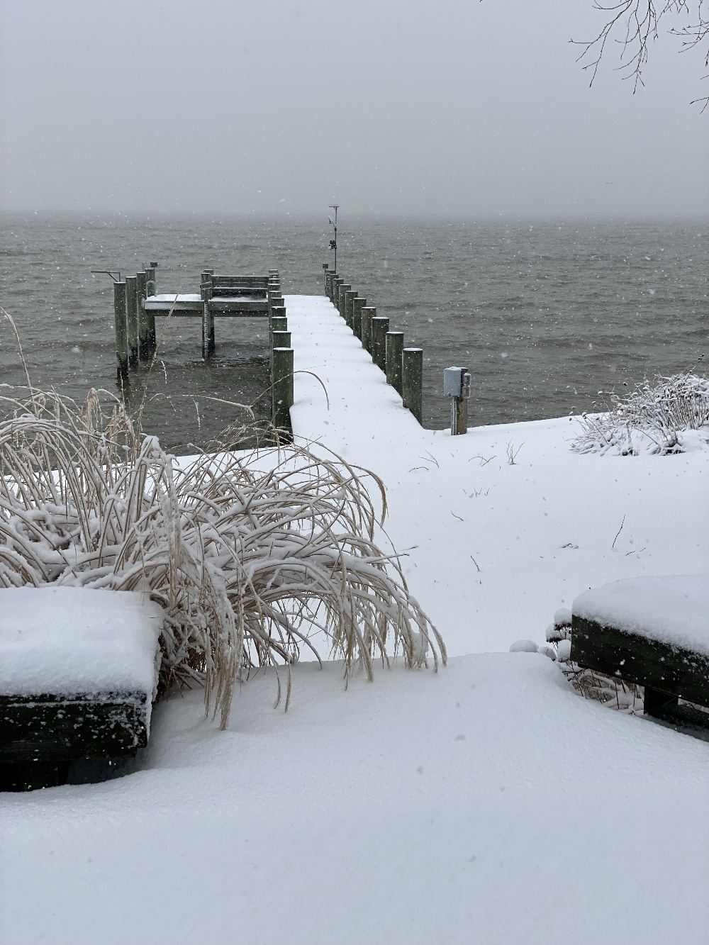
Just measured:
1.5" near the house (~50-75 feet from Chesapeake Bay)
3.5" further inland (~125 feet from Chesapeake Bay)
Might be more up at the road (~400 feet from bay), but didn’t walk that far.
Typical for snow storms for me. One reason I never do skywarn reporting on snow accumulation - between wind and temperature differences due to the bay, I often have drifting and/or a depth gradient with more snow further from the water.
-
Haven’t had a lot of accumulation here, but it sure is pretty! I was above freezing until after dawn, sitting at 30.7F now.
Photo of my weather station in SN:

-
10
-
-
Clearly it's about who creates the thread as to whether we get an event.

-
1
-
-
1 minute ago, WxUSAF said:
After being very stubborn with only 1-3" for Monday-Tuesday, WBAL of course flips to too bullish for Friday with widespread 2-4".
Are they still using the RPM model?
-
1
-
-
40 minutes ago, stormtracker said:
Go ahead. And do pbp for the GFS...gym day. 0z really will be telling
Starting the PBP, the -72 hr 500mb vorticity on the 18z matches the -66 hr 500mb vorticity on the 12z. We're off to a good start!
-
 1
1
-
-
1 minute ago, LeesburgWx said:
Wasn't HRRR in Quebec with the last storm until 6 hours into the event?
Maybe? I know the HRRR had us getting almost nothing last storm. I really didn't pay much more attention than that.
-
1 minute ago, NorthArlington101 said:

I'm only getting 8.3" on that. Can you find a ratio that gives me more? I want to be in those 10"+ zones up over Baltimore.
In all seriousness though, while I like what the GFS is showing, this setup for a storm historically hasn't produced well for us. There's a chance, and us weenies
 will be hanging on for dear life to that chance, but I'm not being overly hopeful until we reach Sunday and it still shows this solution.
-
1
-
 3
3
-
-
Where's the CRAS. I want something that gives us more snow than the Euro!

-
1
-
-
1 hour ago, H2O said:
At least most of the stuff you work with HAD coordinates. Old plats and deeds I worked on only gave descriptions like:
From the stump by old man Miller's barn go northerly 100 rods to the rock. then go northeasterly 50 chains to the cedar post next to Ichabod Crane's headstone, thence southerly 85 cubits to the middle of the crick in Johnston's potato field, then westerly 400 paces to the point of beginning.
If I even had NAD27 I cried tears of happiness.
Hey, Ichabod Crane's headstone is a nice stone monument point to base everything else off of! You should be glad they actually included something that wasn't going to decay!
-
1
-
1
-
-
15 minutes ago, WEATHER53 said:
Her synopsis does not match the conditions the bay produces with strong southerly wind direction for 6+ hours.
I think this is a top 5 all time tide heightvat Annapolis. That is In Fact, exceptionalLast night was #3 on record at 5.11ft MLLW in Annapolis.
#2 was 1933 at 6.18ft MLLW.
#1 was 2003 at 7.20ft MLLW.
That's at least for the timer period we have records for.
-
1
-
-
21 minutes ago, H2O said:
How dare you hate on NAVD29!!!!! I set so many benchmarks off monumentation that was NAD29!!!
My pier was height surveyed using NAVD88 for power (required in AA county) so that's what I used as a basis since I had that precisely at 6ft 2in to the deck of the pier

-
1 hour ago, Eskimo Joe said:
Good thing the Bay Bridge was closed.
Nothing really exceptional about that video. Waves of that size are pretty common on the open bay - I get them many times every year with nor'easters. The fetch in that video appears to be from the east and the location appears to be somewhere near the Northrup Grumman facility based on the bridge angle, so only about 5 miles of fetch creating those waves, not the long southerly fetch that was expected to bring us 5-6 foot waves. They look around 3-4 foot there. It might seem rare for people that don't see the bay violent on a regular basis, but it isn't all that rare. What's rare is the 70+ MPH gusts that we were having on the bridge for about 4 hours straight. That's why the bridge was closed. But remember that the bridge deck is a few hundred feet up, winds at the surface may not have ever reached 70. My exposure is wrong to get the strongest winds, so I can't really comment on what the bay south of the bridge was seeing.
-
3
-
-
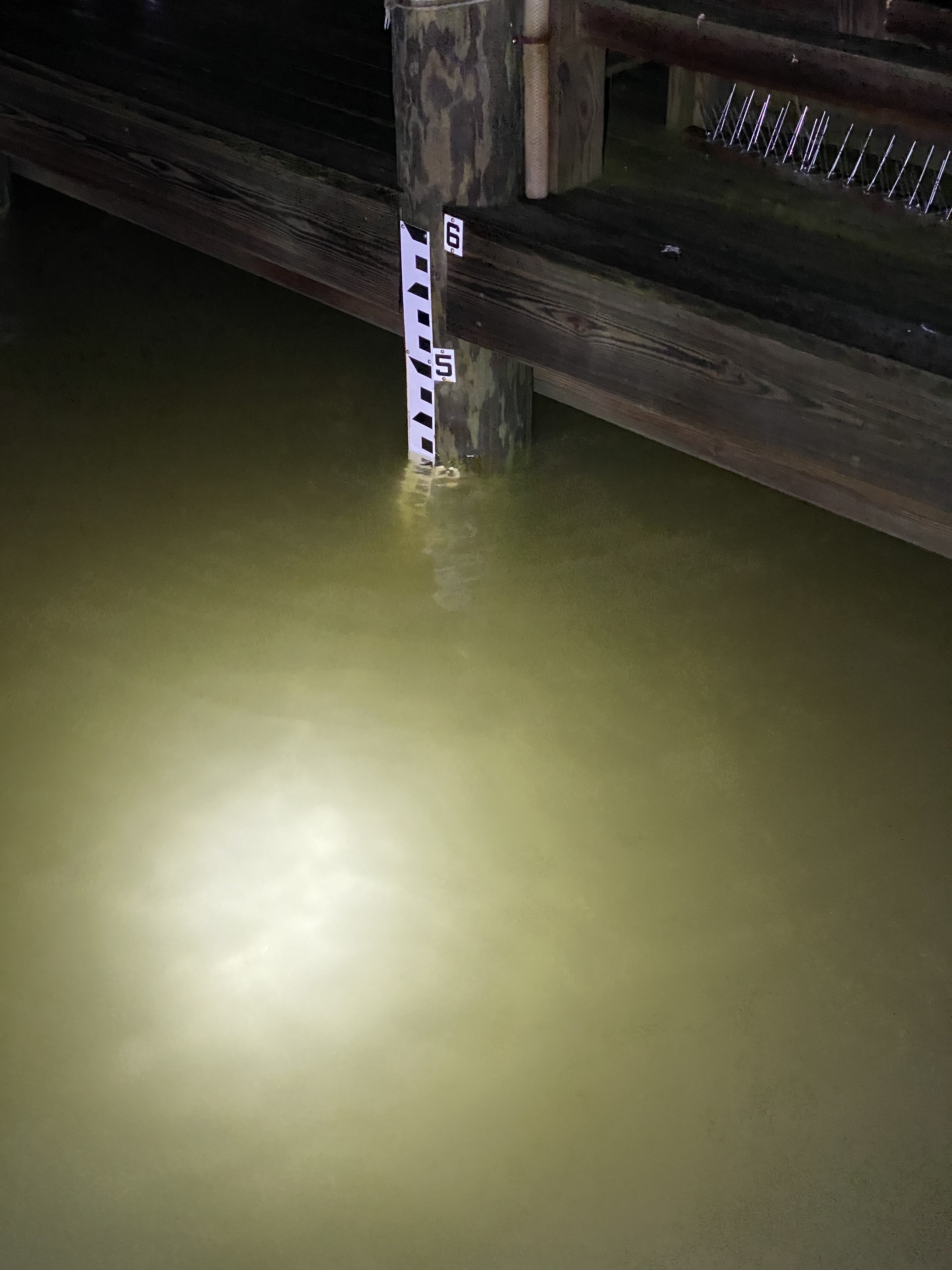
Annapolis is currently 4.67 feet MLLW (3.86 feet NAVD88). Forecast is for this to reach 5.5 feet MLLW for Annapolis in just over an hour (about another foot), then to stop rising.
I am calibrated to NAVD88 and this is what my gauge reads just north of the Bay Bridge:

-
4
-
-
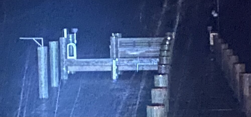
Staff guage indicates about 3.5 foot NAV88 Datum. This picture you can somewhat see the 4 and 5 markers on the side of my gauge. Also winds just switched from SE to W with a lull between the angles with almost no wind.
-
Mesoscale Precipitation Discussion 0007 NWS Weather Prediction Center College Park MD 236 PM EST Tue Jan 09 2024 Areas affected...Central MD...Central VA...North-central NC...DC Concerning...Heavy rainfall...Flash flooding likely Valid 091935Z - 100135Z SUMMARY...Prolonged moderate rain with some quick moving convective line further south, crossing saturated grounds likely to induce flooding conditions through the evening/ early overnight period. DISCUSSION...19z surface analysis and VWP network sfc to 925mb flow show warm front is starting to surge northeast under strong low level southeasterly flow transporting enhanced moisture from the western Atlantic feeder off the Sargasso Sea. CIRA LPW depict a sharp gradient in the lowest level in the vicinity of the the NC/SC line and generally where higher higher theta-E air and weak mid-level instability to help maintain quick moving convective line across currently from Rockingham to York/Union county NC. Combined with quick veering at the effective cold front, allows for total moisture flux into the column enough to support 1.5" totals in sub-hourly time frames (generaly 1"/15-20 minutes). This line of enhanced convection is starting to move into areas with reduced upper level soil capacity and lower FFG values across north-central NC into southern VA. As such, greater than normal runoff is likely to induce flooding, perhaps flashy initially before leading to a broader areal flooding that will impact more surrounding smaller/combining watersheds across the region, especially in urban locales. Further north, CIRA LPW values are reduced, but slug of 700-500mb mid-level moisture and favorable mid to upper-level divergence/diffluence should support moderate rainfall. Here, duration is going will be more likely to result in inducing broad areal flooding conditions across central to northern VA, central MD into south-central PA. Here, hourly FFG values are below 1" and are about .5"/hr in urban centers (which is likely to be exceeded as the main mid to upper-level height falls cross the area from WSW to ENE from 23-01z. Spotty totals of 1-2" are less likely to exceed 3hr FFG values, but still should be broad enough in exceedance to have solid confidence for likely flooding conditions this evening. Gallina ...Please see www.wpc.ncep.noaa.gov for graphic product... ATTN...WFO...AKQ...CTP...LWX...RAH...RNK... ATTN...RFC...MARFC...SERFC...NWC...-
1
-
-
Pressure down to 998.5mb; 22 hours ago I was 1030mb. Wind seems to have dropped back a little and shifted, had been east but now morw SE, supposed to go SSE. 0.89" rain so far.
-
11 minutes ago, RevWarReenactor said:
Aberdeen Proving Ground sent everyone home at 1300 and maximized telework tomorrow for sunny skies.
Pretty insane. This storm better deliver, or the CG won't budge when we get snow.
They are also expecting 6-7 foot tides with 5-6 foot waves from the south at Aberdeen. Likely they will have roads covered and/or washed out with this storm.
-
1
-
-
Just now, Mrs.J said:
Parents in Frederick Co. remember this image from Fall 2021. We are more than fine with a 3 hr. early dismissal up here.

Was that the October 30/31st storm?
-
Tide monitoring page from NOAA for the storm:
https://tidesandcurrents.noaa.gov/inundationdb/storm/East_Coast_Storm.html


April 8th Eclipse- Last Easy One To See In My Lifetime
in Mid Atlantic
Posted
If you had a hydrogen alpha scope, there was a spectacular arch shaped promenance erupting from the bottom of the sun that whe the eclipse started was sticking well past the moon while the sun it came from was hidden!