

gopper
-
Posts
283 -
Joined
-
Last visited
Content Type
Profiles
Blogs
Forums
American Weather
Media Demo
Store
Gallery
Posts posted by gopper
-
-
22 minutes ago, nw baltimore wx said:
Got a break tonight and the storm jumped east and is passing through here. Not a ton of rain, but needed, nonetheless. I’ll take what we can get this week.
And awesome thunder.
Wow! Loudest thunder I have heard in a long time. Scared the cat right out of her nap! The wife and I heard a click when the lightning flashed, as if it sent a charge to our wires....Then BOOM! Startling!
-
 1
1
-
-
DCA: 12/1
IAD: 11/8
BWI: 11/10
RIC: 11/11
Tie Breaker: 0.58"
-
6 minutes ago, Mrs.J said:
Oh my the family said I hit it out of the park with this dinner. Cilantro Lime Chicken with Roasted Sweet Potato Salad. The chicken thigh fell off the bone and the hint of lime and cilantro put it over the top!

https://www.themediterraneandish.com/cilantro-lime-chicken-thighs-recipe/
I'm hoping to see some cicada recipes from you in the other thread!!
")
-
 3
3
-
-
wet snow globs mixing in with rain in Towson
-
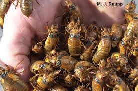
They thrive in older neighborhoods with lots of trees. I remember in 2004 going out at dusk, running my hand along the ivy under a maple tree and having an entire hand full with no effort at all. Love when they emerge out of the ground before molting!
-
1
-
 1
1
-
-
1 hour ago, WinterWxLuvr said:
It’ll be number 30. Book it
We deserve it! We paid our dues! Make it happen!!
-
Now this is a thread I can sink my teeth into!! I actually think the brood of cicadas is one of the most amazing natural wonders in our area. I remember graduating from high school in 1987 with an outdoor graduation. The weather was beautiful, but people in the audience actually put umbrella's up thinking it would keep the cicadas away from their hair...umm...it did not work. The sound they were making was so loud you could barely hear the speakers. I graduated from a private school where we all wore white tuxedo's, not gown and cap, so the buggers were easy to spy on all of our white tuxes. I thought it was awesome! Will never forget my high school graduation, that's for sure!
Then the next time they appeared, I had 2 young children. My wife and I decided we would enter the realm of trying to eat the bugs! Stir fried cicadas, cicada bread, and cicada cookies are a few of the things we tried. I remember convincing my 4 year old that they would be great to eat. She ate them and seemed to really enjoy them. My 2 year old would have nothing of it! She gave an angry face and spit them out. In all honesty, I found them to be bitter and not worth the effort of eating them. A little too earthy tasting for me, but now that I am 17 years older, and my taste buds are almost all dead, I may just have to try them again.
Can't wait to see a deeper covering of bugs than many of our snow events this year

-
1
-
1
-
1
-
-
39.380070
-76.604470
-
I know it's the RGEM and all, but it has had a Baltimore Bulls-Eye for at least 4 runs in a row now. Did Baltimorewx bribe the Canadians?
-
2
-
2
-
-
20 minutes ago, stormtracker said:
Yeah, I decided to leave it because it's going to fail anyway, thread or not.
Watch this lame threat become our biggest snow fall of the year....LOL
-
2
-
5
-
 2
2
-
-
RGEM = Baltimore Bulls Eye!!
-
1
-
1
-
-
Rule of Ji: "The model that gives the least snow always wins!" Looks like Euro want to win this time.
-
3 minutes ago, Maestrobjwa said:
Alright can somebody clear up for me the whole Z system? What time (on the clock) is 0z? Or does it vary by model?
https://www.nco.ncep.noaa.gov/pmb/prod_overview/local_gmt_conversion.shtml
I still need to look at this chart. My memory is not good, so it helps to look at the chart when I forget.
-
1
-
-
10 minutes ago, leesburg 04 said:
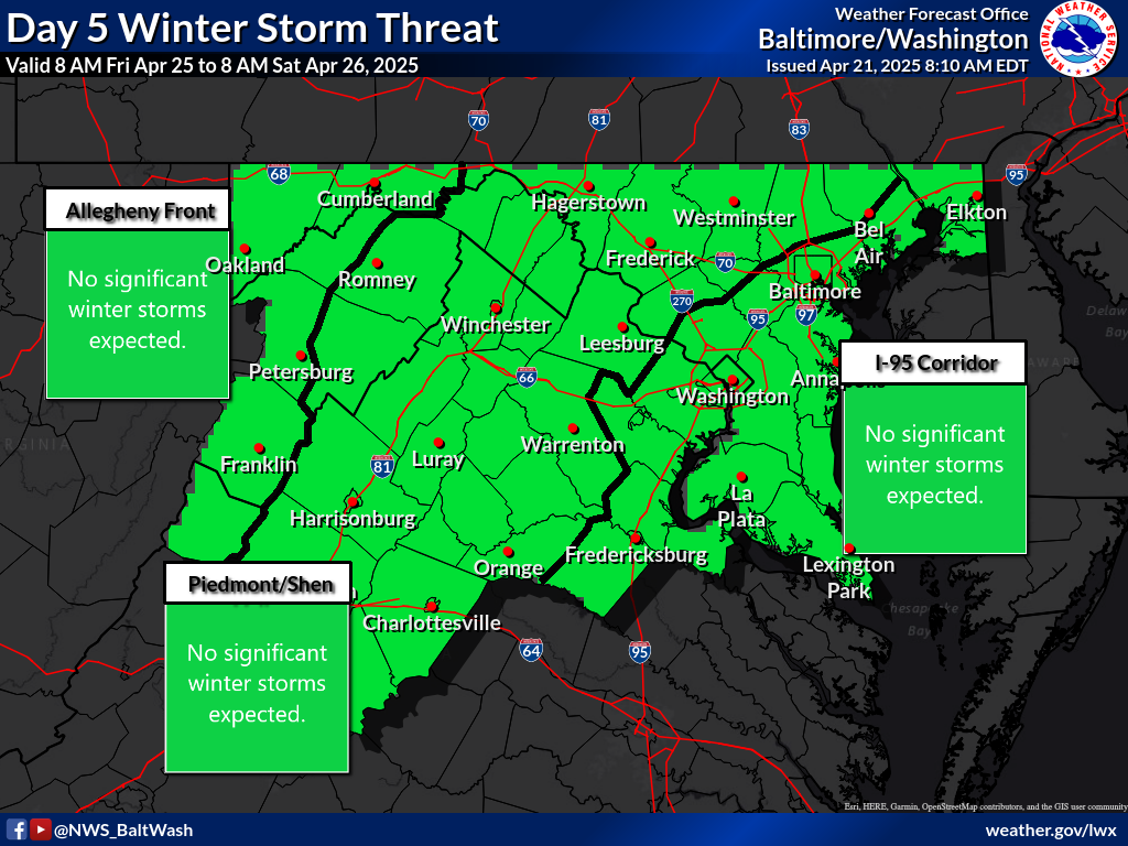
I was just assuming that yesterday day 3 was red which is now day 2 so they aren't showing that in the 3-7 day threats
They need one of those graphics for days 1-2 to clear up confusion.
-
1
-
-
4 pm Temp on Monday, 2/15
DCA: 36
DFW: 15
DEN: 21
Low temperature for Tuesday, 2/16
DCA: 30
DFW: 15
DEN: 17
-
moderate to heavy snow with medium size dendrites falling
Roads caving!
-
3
-
-
Son just reported that there are now "some big fluffy flakes"! I trust he was talking about the snow!!
Towson
-
3
-
-
Legit flakes now in Towson. Pixie dust getting replaced by dendrites!!
-
4
-
-
Back from a run. Very light snow in Towson. Can barely feel it on your face....just a light tickle. Cars starting to look white, but no accumulation yet. Need the rates! Might be hard to sleep tonight!
-
3
-
-
snow flurries in Towson
-
2
-
-
snow flurries in Towson (little styrofoam balls). Woohoo! Round 1 has begun
")
-
I refuse to believe any of this snow is going to happen until usetobe chimes in!
-
2
-
-
-

I wont get suckered in! I won't get suckered in! Oh Hell!! I'm in!!
-
2
-

Winter 2021-22
in Mid Atlantic
Posted
IF there is any validity to this, wouldn't the pattern actually be a couple/few weeks later as models tend to change patterns too soon? That would bode well for December, IMO.