

tnweathernut
-
Posts
4,649 -
Joined
-
Last visited
Content Type
Profiles
Blogs
Forums
American Weather
Media Demo
Store
Gallery
Posts posted by tnweathernut
-
-
40 minutes ago, jaxjagman said:
Could be the kiss of death for early severe which was what i was thinking could happen

For the sake of your (and everyone else’s) property insurance rates, we better hope we get a few tranquil years in a row…. Already seeing 20-35% increases this year, with more likely on the way in the years to come because of the last 3+ years.
-
 4
4
-
-
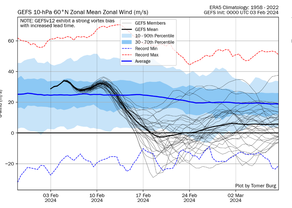
Not trying to be a wet blanket, but does anyone remember the year where there was almost complete agreement we were headed toward a great pattern. Almost all ensembles were pointing toward it, and I think we were fringe OP range. Then, a SSW occurred and modeling did a 180. I don't remember the year, but I remember having a very different view of SSW's the year that happened.
-
1
-
-
17 hours ago, Carvers Gap said:
We gettin' ready to fix that problem for ya. LOL. The battle is under way. Donde vs the NCAA.
I hope all other SEC schools will join the lawsuit with TN and VA. It's time to disband the NCAA.
I'd equate it to conservatives being targeted in politics while certain liberals get a total pass. Anyone remember the NC academic scandal, LSU's Will Wade being caught on tape paying players before NIL, AL covering up drug/gun incidents, paying players, etc...., The NCAA acting on transfers before the portal in less than a week while sitting on others for months. The list goes on and on. It's time they either go or be cut down to size.
-
7
-
-
1 hour ago, PowellVolz said:
I wouldn’t say SC played dirty but I understand what you are talking about. They took advantage of what the refs allowed them to do. The post guy would make room with his elbow by beating it against our chest and when we stood our ground, we got called for the foul. I can’t blame SC for doing that when the refs let them.
.I was very frustrated watching the game, and not just because I am a Tennessee fan. The amount of aggression they allowed SC in the second half while calling numerous touch fouls on us early changed the complexion of the game, IMO. I will say even with that against them if TN simply hits layups and FT's, they win by 10. Their D was good enough to win that game 99 out of 100 times. TN has shooters. It's inconceivable to me they shoot that poorly from 3 in their home gym.
-
1
-
-
13 minutes ago, Holston_River_Rambler said:
Big ol Miller A/B hybrid incoming on the 12z GFS in fantasy range.
But the big high is dropping down again. Four out of the last five runs now.
That run ended with a raging snowstorm in northern Mexico............. lol
One word summarizes the direction we are heading - "potential"
-
7
-
-
4 minutes ago, CheoahBald1 said:
DT (the snowstorm page twitter) seems to believe Tenn valley is still in the game for the feb 4-6 event?? Thoughts?
.JMO, but I think he's reaching even calling locations for a snow storm this far in advance. He's good, but I generally don't listen to him for our area (and especially the microclimate known as northeast TN). The biggest problem we will have this side of the apps is cold air. Would be incredibly rare to have cold "enough" air come down through the lakes and spill west of the apps. Cold air damming is a distinct possibility for our friends on the other side of the mountains. I think if this snow storm belongs to anyone, it's probably those guys (NC/VA).
-
4
-
 1
1
-
-
This will work……..

-
8
-
-
I put this in the wrong thread and just wanted to move it to the correct thread....
Congrats to everyone who saw a fantastic snow!! This one wasn’t what some of us wanted, but it’s always fascinating to track and see what goes right vs what goes wrong and which models handle things the best. Those models showing warming banked up against the west side of apps were correct, even into much of Washington County. The HRRR and RAP did well. The ARW never found the warm layer and was the most wrong, IMO. Of course the globals in close were in the ARW boat from within 48 hours, showing the NE TN getting hammered. This is to be expected for global models. They just don’t have the resolution needed to score a victory. The RGEM also struggled, and while showing some of the warming, didn’t have it correct as far away from the mountains as what verefied.
In JC we switched back and forth almost all day after a good start to the system. We had a heavy dusting and roads were covered by lunch. Then we flipped to heavy rain and back and forth between rain and snow until around 4:30-5:00. We managed about 3” of slop with heavier bands into the evening, but didn’t make it to below freezing until early this morning. When I went to work we had freezing drizzle and most of what fell on the roads had largely melted. I live north and west of Johnson City proper, and thought I was far enough away from the mountains I could stay all snow.
Although I didn’t get shut out, I relearned a lesson I already knew. Never count out thermal profile problems in northeast TN.
-
1
-
-
52 minutes ago, Stovepipe said:
It just keeps pounding.


Amazing!
-
3
-
-
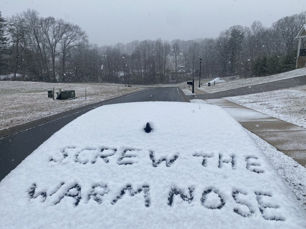
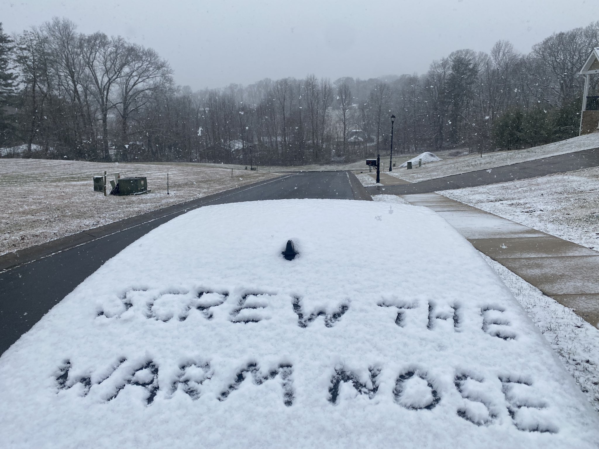
Not my picture but summarizes my feelings well regarding the entire day today where rain has been occurring or mixing in.
-
5
-
 1
1
-
 2
2
-
-
1 minute ago, Carvers Gap said:
TRI has been above freezing all day. I think warming yesterday (clouds moved in later and at perfectly the wrong time) seeded the problems for today. We got too warm yesterday afternoon due to sun. Then clouds moved in and capped that warmth so it couldn't radiate out. Time of day IMO was the single, biggest determining factor of who got what.
Not sure that was all it was. That didn’t help. Timing for us has been terrible. We did make it to the upper 20s around our region by daybreak. Just couldn’t stay there with the warming of the day and a slight downslope off the mountains. I didn’t think it would happen, but remember leaving a post saying I never totally discount it around here.
-
1
-
-
3 minutes ago, AMZ8990 said:
You guys should be really good in the east side of the state. It snowed for nearly 24 hours on the west side of the state so you guys are in for a long and steady snowfall. Sitting at 5 1/2 inches in bolivar
Except up here in JC where it’s raining. lol
-
 3
3
-
-
Changed over to rain currently in/around Gray and Boones Creek. Still snowing at the office in Erwin, but there's definitely a battle going on upstairs.
-
1
-
-
4 minutes ago, fountainguy97 said:
Beautiful snow. Roads turning slushy and white. Hate we are abt to cross 32 here.
Agree. It's a battle. Maybe the ARW can score a victory over all the other short range modeling.
-
1
-
-
Flipped to big flakes, light to moderate snow in Erwin (city). There's a battle going on.
-
4
-
-
There's a battle going on in Unicoi County. Here in town we are alternating between larger and smaller dendrites. I hope this isn't the beginning of a mix or change over, but it's possible.
-
I'm wanting to get through what is to be the heaviest part of the storm before I do my post-mortem and diagnose winners and losers in the modeling department. Next 6-12 hours will tell the story, but that's just me.
-
3
-
-
Just now, ShawnEastTN said:
Closing in on 3" Northern Meigs on the Roane line. View into the woods behind my house.

That's awesome, Shawn. Love snowy scenes. ENJOY!
-
2
-
-
Just now, fountainguy97 said:
Yeah I'm at 30.2 and actually dropped from 30.4 under this snow. How long can I hold out before the transition?
hrrr was already above 32 hrs ago for me.
It's going to be fascinating to watch it play out. If we can get in the heavy stuff, sometimes it's harder to change it.
-
1
-
-
3 minutes ago, Stovepipe said:
It's really coming down here. These chickens don't know what to make of it.


PRETTY!!! Thanks, Stove....... Those chickens are like. "yeah, NO this sucks"
-
1
-
-
Not going to lie. HRRR is pretty "cringe" for anyone just west of the apps..... Snowing here in Erwin, guessing a 1-2 mile visibility.
-
You guys getting a good snow need to get better at taking pictures and sharing with us.... Just a casual observation. lol
-
2
-
-
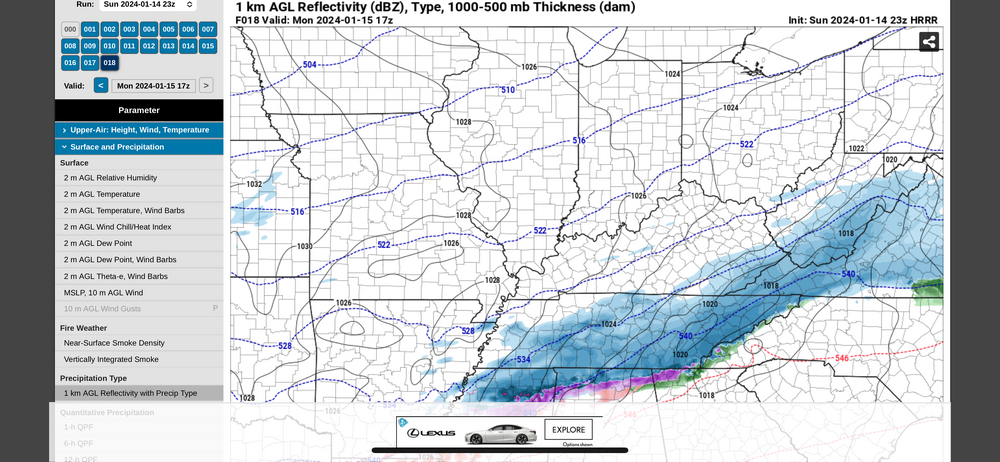
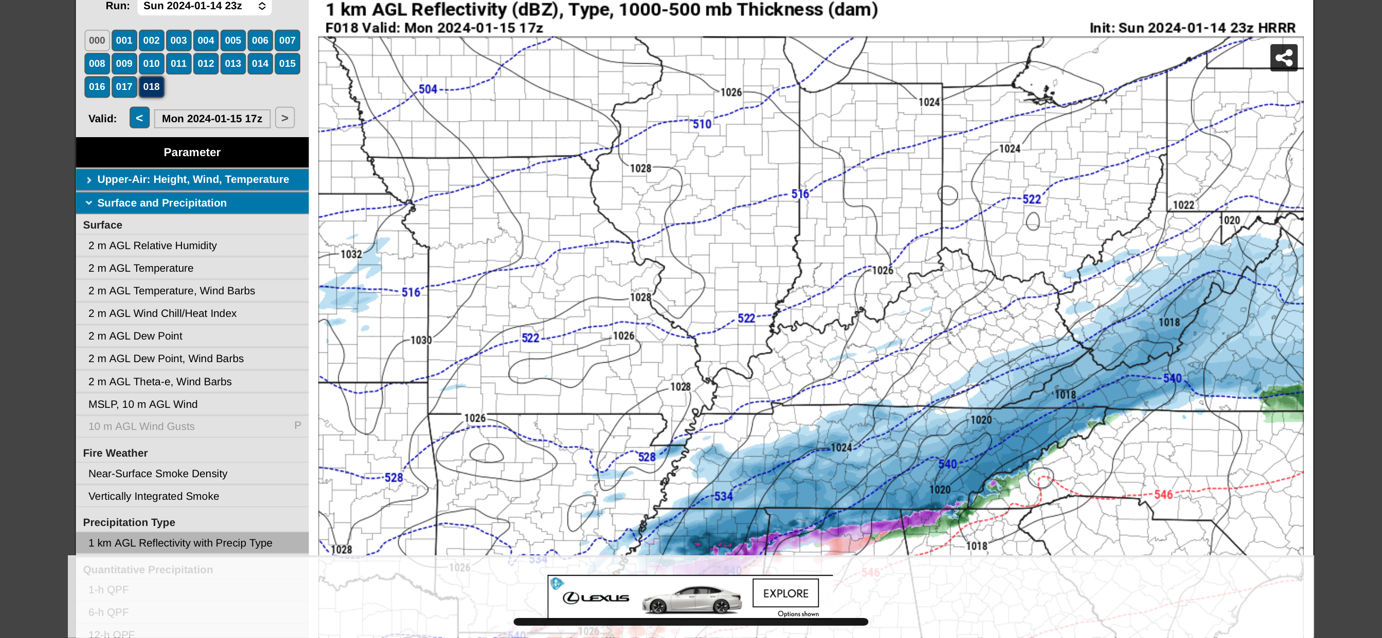
And this is the last hour of that model…. 17z. (12 noon). Most of what falls in east TN comes tomorrow after this time and into the evening. Still looks good to me.
-
5
-
1
-
-
3 minutes ago, Carvers Gap said:
The RGEM really beefed up amounts. The 18z RGEM brings the entry point in the forum area slightly north of 12z. It still flattens the system as it heads eastward. That slight changes increases amounts over middle TN. Last minute northwest trends are not uncommon. We actually "stole" a system many years ago from North Carolina on a 48 hour trend at the last minute. If the cold in middle TN is stronger than expected, there will be a likely limit as to how far it can trend northward. More than anything we are seeing an expansion of the northern precip shield vs a major movement of the snow demarcation line to the south. About a one county jog northwestward for the southern extent of snow. Also to account, there is a certain amount of ebb and flow noise in modeling.
It makes sense and I’ve mentioned it before, but when any storm involves overrunning, precip normally breaks out faster, is quicker, and the precip shield is often further north than modeled. I know you know this, just trying to piggy back off your comment to add to the discussion.
-
2
-

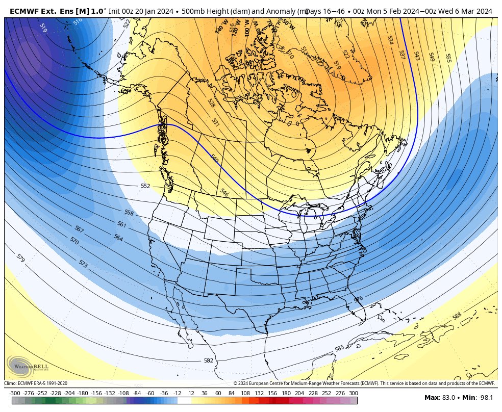
February 2024 mid/ long range
in Tennessee Valley
Posted
Systems all year have been trending south and east. Let's see what happens when we need it most. lol