
alex
-
Posts
4,160 -
Joined
-
Last visited
Content Type
Profiles
Blogs
Forums
American Weather
Media Demo
Store
Gallery
Posts posted by alex
-
-
Warmup was short lived, changing back to snow here. All in all, a great storm and a nice net gainer of heavy base snow
-
 4
4
-
-
About a foot here, but getting compacted down with the rain and warm temps. Wild evening last night though
-
27 minutes ago, dmcginvt said:
I dont care if it changes to rain, these snowfall rates I am seeing right now are worth it. It's just silly and presumably early still. 2/14/2007 is the only time that comes close. It's snowing so hard.
I agree. Even if we wake up to grass, this storm is a winner in my book. Just awesome to watch. Not to drive in though @#NoPoles
-
 1
1
-
-
2 minutes ago, powderfreak said:
It’s the inversion level IMO. It dictates how the moisture moves over the terrain.
I’ll need an explanation of that
") It is bizarre, temperature steady and heavy snow but there’s a bunch of 4-5000 footers in the direction the wind is coming from
It is bizarre, temperature steady and heavy snow but there’s a bunch of 4-5000 footers in the direction the wind is coming from
-
Definitely no sign of downsloping yet in spite of the wind. I don’t understand why sometimes we do sometimes we don’t with the same wind direction
-
5
-
-
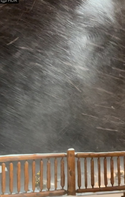
It’s like full on blizzard out there. Wasn’t expecting that
-
2
-
-
46 minutes ago, TauntonBlizzard2013 said:
Have you not heard about my ski trip at the end of January? These are important runs
lol. And some of us DO live there
-
2
-
-
Pounding like I haven’t seen in a while here too
-
2
-
-
5 minutes ago, DavisStraight said:
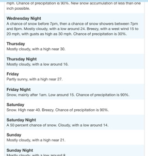
What's the pack like right now in your area? I'm going up Feb 2nd for the weekend. Looking at models should be a nice pack by then.
Only 5” or so on the ground, and who knows if that will be there by morning… hopefully that will change soon though!
-
1
-
 1
1
-
-
Only light snow here but it’s absolutely miserable with 24F, gusty wind, and snow blowing everywhere
-
1
-
 1
1
-
-
22 minutes ago, ORH_wxman said:
Flickering hope in SNE. It needs to trend better in the next day or so or it’s junk. It does look decent for NNE. They may actually build a decent pack over the next week since some of the spots are going to get a solid net gainer on 1/10 too even though it eventually flips.
Both of those systems would have been nice if they were weak vort maxes but these are both on ‘roids so they are able to overcome some initial confluence.Cutters are hard for us, other than the fact that we still usually end up with decent cover from the follow up upslope. We’ve had some really “good” cutter for pack building but they seem to be a thing of the past. That said, GYX sounds optimistic.
-
32 minutes ago, Torch Tiger said:
Relatively maybe, but often I noticed there's little snow to preserve there despite the CAD. Of course there are weenie spots in that area, too, but I was just talking Conway/North Conway in general. We used to stay in N. Conway at around 1200' fairly close to Cranmore, the snow pack (when there was some) was noticeably better than in-town below 1000' and surely 500', sometimes double or triple
True - and admittedly I think of Bartlett, where I used to be, as North Conway. North Conway proper suffers from low elevation
-
3
-
-
1 hour ago, Torch Tiger said:
should have booked Jay or the loaf, mediocre to bad winters with cutters are rough in Conway <3
I'd say if there's one place that does well in cutter it's Conway. They CAD like nobody's business. I don't know much about Jay other than the few times I've been there and witnessed what they called 8" of snow that were really a dusting that my wipers could remove in about 2 strokes
-
1
-
1
-
-
Awesome day today. I have low expectations for Wednesday at my location with SE wind, but we’ll see. We’ve had “good cutters” before that helped build a strong base, just not recently
-
2
-
-
2 minutes ago, dryslot said:
Pretty impressive for many
000
NOUS41 KGYX 080332
PNSGYX
MEZ007>009-012>014-018>028-033-NHZ001>015-081532-

Public Information Statement
National Weather Service Gray ME
1032 PM EST Sun Jan 7 2024

...SNOWFALL REPORTS...

Location                     Amount    Time/Date       Provider

...Maine...

...Androscoggin County...
4 S Turner                   11.0 in   0631 PM 01/07   Trained Spotter
2 NW Auburn                  8.2 in    0602 PM 01/07   Trained Spotter
2 W Lisbon Falls             7.8 in    0552 PM 01/07   CO-OP Observer
1 W Mechanic Falls           7.7 in    0946 PM 01/07   NWS Employee
2 N Lisbon                   7.5 in    0741 PM 01/07   Trained Spotter
Mechanic Falls               7.5 in    0918 PM 01/07   Public
2 E Lewiston                 7.0 in    0625 PM 01/07   Trained Spotter
4 S Livermore Falls          5.3 in    0517 PM 01/07   NWS Employee

...Cumberland County...
3 SSE Standish               18.0 in   0919 PM 01/07   Trained Spotter
1 N Gorham                   17.0 in   0833 PM 01/07   Trained Spotter
2 WSW Falmouth               16.0 in   0719 PM 01/07   NWS Employee
2 SSW Cumberland             15.5 in   0510 PM 01/07   Trained Spotter
1 N Cumberland               13.9 in   0605 PM 01/07   Trained Spotter
2 S Cumberland               13.8 in   0731 PM 01/07   Trained Spotter
4 SSE Gorham                 13.5 in   0536 PM 01/07   Trained Spotter
Standish                     13.2 in   0430 PM 01/07   Trained Spotter
3 SSE Gray                   13.0 in   0729 PM 01/07   Trained Spotter
1 NW Freeport                13.0 in   0750 PM 01/07   NWS Employee
Gorham                       12.8 in   0700 PM 01/07   Trained Spotter
1 NE Portland Jetport        12.7 in   0831 PM 01/07   Trained Spotter
Portland Jetport             12.6 in   0700 PM 01/07   ASOS
1 SSW Brunswick              12.5 in   0944 PM 01/07   Trained Spotter
Freeport                     12.0 in   0503 PM 01/07   Public
2 N Old Orchard Beach        11.6 in   0831 PM 01/07   Amateur Radio
3 E South Windham            10.5 in   0151 PM 01/07   NWS Employee
2 SW Falmouth                10.3 in   0152 PM 01/07   Public
5 S Bridgton                 9.5 in    0612 PM 01/07   Trained Spotter
1 NNW Cape Elizabeth         9.5 in    0832 PM 01/07   Trained Spotter
South Portland               9.5 in    0832 PM 01/07   Trained Spotter
4 WSW New Gloucester         9.0 in    0429 PM 01/07   NWS Employee
NWS Gray                     8.8 in    0700 PM 01/07   Official NWS Obs
1 S Portland Jetport         8.0 in    0148 PM 01/07   Trained Spotter
5 S Bridgton                 7.0 in    0249 PM 01/07   Trained Spotter

...Kennebec County...
2 W Litchfield               10.3 in   0951 PM 01/07   Trained Spotter
1 SW Gardiner                7.5 in    0649 PM 01/07   Public
Randolph                     7.3 in    0943 PM 01/07   Trained Spotter
2 WNW Hallowell              7.0 in    0400 PM 01/07   Public
2 WSW Gardiner               6.8 in    0746 PM 01/07   Trained Spotter
2 WNW Whitefield             6.5 in    0834 PM 01/07   Trained Spotter
1 ESE Augusta                6.3 in    0620 PM 01/07   Trained Spotter
1 NW Farmingdale             6.0 in    0316 PM 01/07   Public
3 ENE Vassalboro             5.5 in    0645 PM 01/07   Trained Spotter

...Knox County...
1 WNW Tenants Harbor         10.8 in   0830 PM 01/07   Trained Spotter
2 SW Friendship              10.3 in   0444 PM 01/07   Trained Spotter
Thomaston                    9.5 in    0845 PM 01/07   Trained Spotter
2 SSW Tenants Harbor         8.5 in    0837 PM 01/07   Trained Spotter
Hope                         7.5 in    0800 PM 01/07   Trained Spotter
Camden                       6.7 in    0942 PM 01/07   Trained Spotter
2 SE Washington              5.0 in    0852 PM 01/07   Trained Spotter

...Lincoln County...
1 SSW Nobleboro              9.8 in    1006 PM 01/07   Public
2 SE Alna                    9.0 in    0742 PM 01/07   Trained Spotter
1 W South Bristol            8.6 in    0630 PM 01/07   Trained Spotter

...Oxford County...
3 WNW Brownfield             9.5 in    0236 PM 01/07   Trained Spotter
Fryeburg                     8.5 in    0629 PM 01/07   NWS Employee
1 S Waterford                8.5 in    0425 PM 01/07
1 NNE Lovell                 7.5 in    0430 PM 01/07
3 SW Peru                    7.0 in    0340 PM 01/07   Public
2 NE Oxford                  7.0 in    0140 PM 01/07   Trained Spotter
Bryant Pond                  6.8 in    0334 PM 01/07   Trained Spotter
4 W Stoneham                 5.5 in    0417 PM 01/07   Trained Spotter

...Sagadahoc County...
2 ENE Topsham                10.3 in   0430 PM 01/07   Trained Spotter
Bath                         10.0 in   0445 PM 01/07   Public
1 NW Woolwich                10.0 in   0717 PM 01/07   Trained Spotter

...York County...
5 NNW Acton                  18.0 in   0527 PM 01/07
5 NW Hollis                  17.2 in   0446 PM 01/07   CO-OP Observer
4 NE Shapleigh               16.0 in   0833 PM 01/07   Trained Spotter
1 WSW Kittery                16.0 in   1000 PM 01/07   Trained Spotter
5 NNW Acton                  15.0 in   0129 PM 01/07   Trained Spotter
5 NNW Acton                  14.5 in   0559 PM 01/07   Trained Spotter
5 NNW Acton                  14.2 in   0837 PM 01/07   Trained Spotter
2 SSW East Baldwin           13.2 in   0557 PM 01/07   Trained Spotter
3 NE Limington               13.0 in   0948 PM 01/07   Public
2 WNW Kittery                11.2 in   0729 PM 01/07   Trained Spotter
6 W Lebanon                  10.5 in   0430 PM 01/07   Trained Spotter
Ferry Beach State Park       10.5 in   0651 PM 01/07   NWS Employee
1 SW Old Orchard Beach       10.4 in   0645 PM 01/07   NWS Employee
1 SW Kennebunkport           9.0 in    0912 PM 01/07   Trained Spotter
1 N Kennebunk                9.0 in    0347 PM 01/07   Trained Spotter
2 S Sanford                  8.0 in    0330 PM 01/07   Public
1 SW Kennebunkport           8.0 in    0507 PM 01/07
2 NNE Saco                   7.0 in    0315 PM 01/07   Trained Spotter

...New Hampshire...

...Belknap County...
2 WSW Meredith               13.5 in   0626 PM 01/07   Trained Spotter
1 NNE Tilton-Northfield      11.0 in   0656 PM 01/07   Trained Spotter

...Carroll County...
1 SE Wolfeboro               14.8 in   0658 PM 01/07   Trained Spotter
1 NNW Brookfield             12.5 in   0647 PM 01/07   Trained Spotter
3 SE Albany                  11.0 in   0433 PM 01/07   Trained Spotter
1 ESE Freedom                9.0 in    0430 PM 01/07   Trained Spotter
1 WNW Center Sandwich        8.5 in    0420 PM 01/07

...Cheshire County...
2 SSE Rindge                 10.8 in   0742 PM 01/07   Trained Spotter
1 NE Jaffrey                 8.0 in    0754 PM 01/07   Public
1 ENE Spofford               5.0 in    0300 PM 01/07   Trained Spotter

...Coos County...
Berlin                       5.0 in    0404 PM 01/07   Public

...Grafton County...
5 S Piermont                 14.5 in   0630 PM 01/07   Trained Spotter
5 WSW Littleton              10.8 in   0455 PM 01/07
2 ENE Plymouth               9.7 in    0415 PM 01/07   Trained Spotter
Waterville Valley            9.2 in    0625 PM 01/07   Public
4 ENE Thornton               8.5 in    0629 PM 01/07   Public

...Hillsborough County...
4 SSE Hudson                 15.3 in   0829 PM 01/07   Trained Spotter
1 SW Brookline               15.1 in   0520 PM 01/07
2 SE Brookline               15.0 in   0246 PM 01/07   Trained Spotter
1 ESE Nashua                 14.7 in   0700 PM 01/07   NWS Employee
2 S Nashua                   14.5 in   0600 PM 01/07   Trained Spotter
2 ESE Brookline              14.2 in   0632 PM 01/07   Public
3 SSE Mason                  14.0 in   0645 PM 01/07   Trained Spotter
2 SW Brookline               13.8 in   0220 PM 01/07   Trained Spotter
2 SSW Hollis                 13.4 in   0253 PM 01/07   Trained Spotter
2 S New Ipswich              13.0 in   0959 PM 01/07   Trained Spotter
2 S New Ipswich              12.5 in   0553 PM 01/07   Trained Spotter
1 WSW Nashua                 12.3 in   0528 PM 01/07   Trained Spotter
2 SSW Nashua                 12.0 in   0553 PM 01/07   Trained Spotter
Milford                      12.0 in   0200 PM 01/07   Public
1 ENE Litchfield             11.5 in   0530 PM 01/07   Trained Spotter
3 N Hillsborough             10.1 in   0911 PM 01/07   Trained Spotter
1 SSE Manchester             10.0 in   0822 PM 01/07   Public
1 ESE Milford                10.0 in   0933 PM 01/07   Trained Spotter
1 W Amherst                  9.0 in    0517 PM 01/07
Amherst                      9.0 in    0615 PM 01/07   Trained Spotter
Bedford                      9.0 in    0403 PM 01/07   Public
2 NNE Greenfield             8.8 in    0550 PM 01/07   Trained Spotter
Manchester Airport           8.5 in    0700 PM 01/07   ASOS
2 SE Milford                 8.2 in    0400 PM 01/07   Trained Spotter
1 W Bennington               7.3 in    0625 PM 01/07   Trained Spotter
2 NW Merrimack               7.3 in    0833 PM 01/07   Trained Spotter

...Merrimack County...
4 NNE Warner                 11.5 in   0634 PM 01/07   Public
2 NNE Bradford               11.0 in   0955 PM 01/07   Trained Spotter
Concord Municipal Airp       8.4 in    0700 PM 01/07   ASOS
1 SSE Henniker               8.3 in    0730 PM 01/07   Trained Spotter
2 W Epsom                    7.0 in    0516 PM 01/07
3 E Canterbury               7.0 in    0556 PM 01/07   Trained Spotter

...Rockingham County...
1 E Salem                    18.5 in   0823 PM 01/07   Trained Spotter
2 SSE Salem                  17.0 in   0300 PM 01/07   Trained Spotter
Plaistow                     16.5 in   0750 PM 01/07   Public
Atkinson                     16.0 in   0921 PM 01/07   Public
Newton                       14.0 in   0200 PM 01/07   Public
Chester                      13.8 in   0930 PM 01/07   Trained Spotter
2 NNE Newton                 13.5 in   0622 PM 01/07   Trained Spotter
3 NE Derry                   13.0 in   0750 PM 01/07   Public
Seabrook                     13.0 in   1017 PM 01/07   Public
Londonderry                  12.3 in   0504 PM 01/07   Trained Spotter
2 NNW Chester                11.4 in   0643 PM 01/07   Public
Fremont                      11.0 in   0500 PM 01/07   Public
2 N Raymond                  9.6 in    0530 PM 01/07   Trained Spotter
3 E Seabrook                 9.5 in    0347 PM 01/07
2 NW Lee                     9.0 in    0804 PM 01/07   Trained Spotter
Portsmouth Airport           8.0 in    0700 PM 01/07   AWOS
4 E Epsom                    7.2 in    0427 PM 01/07

...Strafford County...
1 N Milton                   11.8 in   0737 PM 01/07   Trained Spotter
1 ENE Madbury                9.5 in    0545 PM 01/07   Trained Spotter
Durham                       9.2 in    0500 PM 01/07   Trained Spotter
3 SE Dover                   8.5 in    0428 PM 01/07
1 S Dover                    7.6 in    0930 PM 01/07   Trained Spotter
3 NNE Northwood              7.0 in    0821 PM 01/07   Trained Spotter

...Sullivan County...
2 NE Newport                 10.5 in   0432 PM 01/07   Trained Spotter
1 WNW Washington             8.4 in    0735 PM 01/07   Trained Spotter
4 SSW Lebanon                7.0 in    0412 PM 01/07
&&
Mmm Littleton did NOT get 10”
-
About 3” of upslope overnight, moderate fluff still falling
-
Snowing and quite windy. 18F
-
1 minute ago, TauntonBlizzard2013 said:
Bummer
It could go either way. Some cutters have been great to get glades and steep terrain open - the heavy wet snow makes for a great base, and up here it’s usually followed by upslope to create a nice layered “heavy bottom fluffy top”. Of course if the rain is heavy or very warm and all the snow gets washed off, it’s no bueno
-
1
-
-
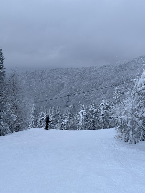
Actually great conditions on the groomers today
-
6
-
-
13 minutes ago, NW_of_GYX said:
GFS coming in colder for the 13th, looks more like euro. Whites crushed on the front end
I remember the first several years I lived here we’d often do really well in cutters, with a good dose of snow to start followed by some drizzle and 38-40 degrees followed by a few inches of upslope to top it off. It made for a great base for getting glades open. Lately it seems like cutters just suck lol. Would be great to change that
-
52 minutes ago, STILL N OF PIKE said:
Big snows for whites on euro wow
My heart is growing frail, don’t do this to me.
JK I’m starting to care less every year that I’m up here. But snow is nice, and especially nice for my business lol. And flooding is bad, very bad.
-
2 minutes ago, NW_of_GYX said:
We’ve been on a remarkable string of these epic cutters going back to the Dec 20’ grinch event. It looks like dog shit as modeled but we’re still 5 days away. The mountains to my NW look to net gain and avoid getting washed away like they did 3 weeks ago at least.
Do they? I thought we were looking at 40s and 2” of rain
-
8 minutes ago, powderfreak said:
Got a nice 3-4” in squalls at the hill early AM through now.

Looks to be making its way here, decently moderate snow atm
-
Tiny flakes but snowing decently

-
1
-
1/9-1/10 Now Morphing to Less-Than-Exciting Power Cutter
in New England
Posted
LOL! Hey, we should get some credit for it being already all shoveled. This stuff is heart attack material - but if you don't do it now, it's not gonna be fun later