
TampaTwo
-
Posts
7 -
Joined
-
Last visited
Content Type
Profiles
Blogs
Forums
American Weather
Media Demo
Store
Gallery
Posts posted by TampaTwo
-
-
If I had to make a call from 48 hours out, I would park myself in Hattiesburg MS and let it ride.....seems to be the best bullseye spot, although certainly not ideal for storm chasing visibility.
-
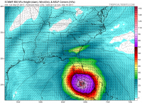
Move along, nothing to see here in Northern Mississippi later this afternoon...
-
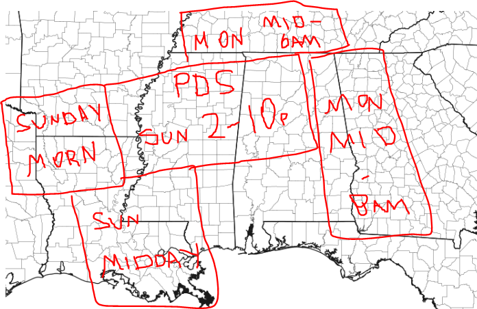
if you will forgive my 5th-grade looking art work, this is my first call of how I think the SPC watch boxes will pop out tomorrow, based on the early CAMs and storm pacing.
-
 1
1
-
-
57 minutes ago, sakau2007 said:
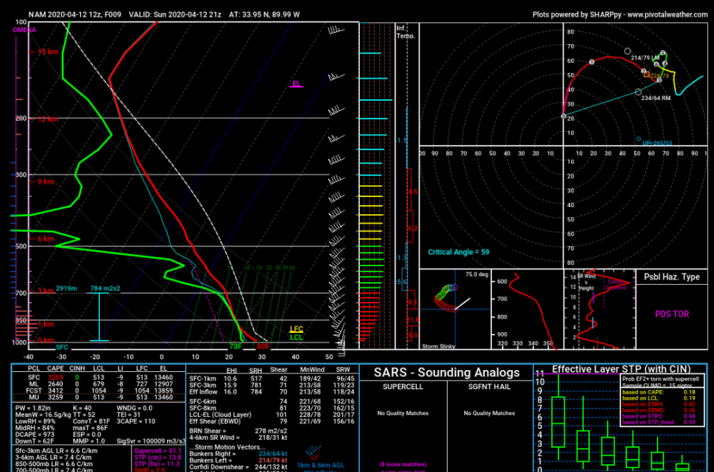
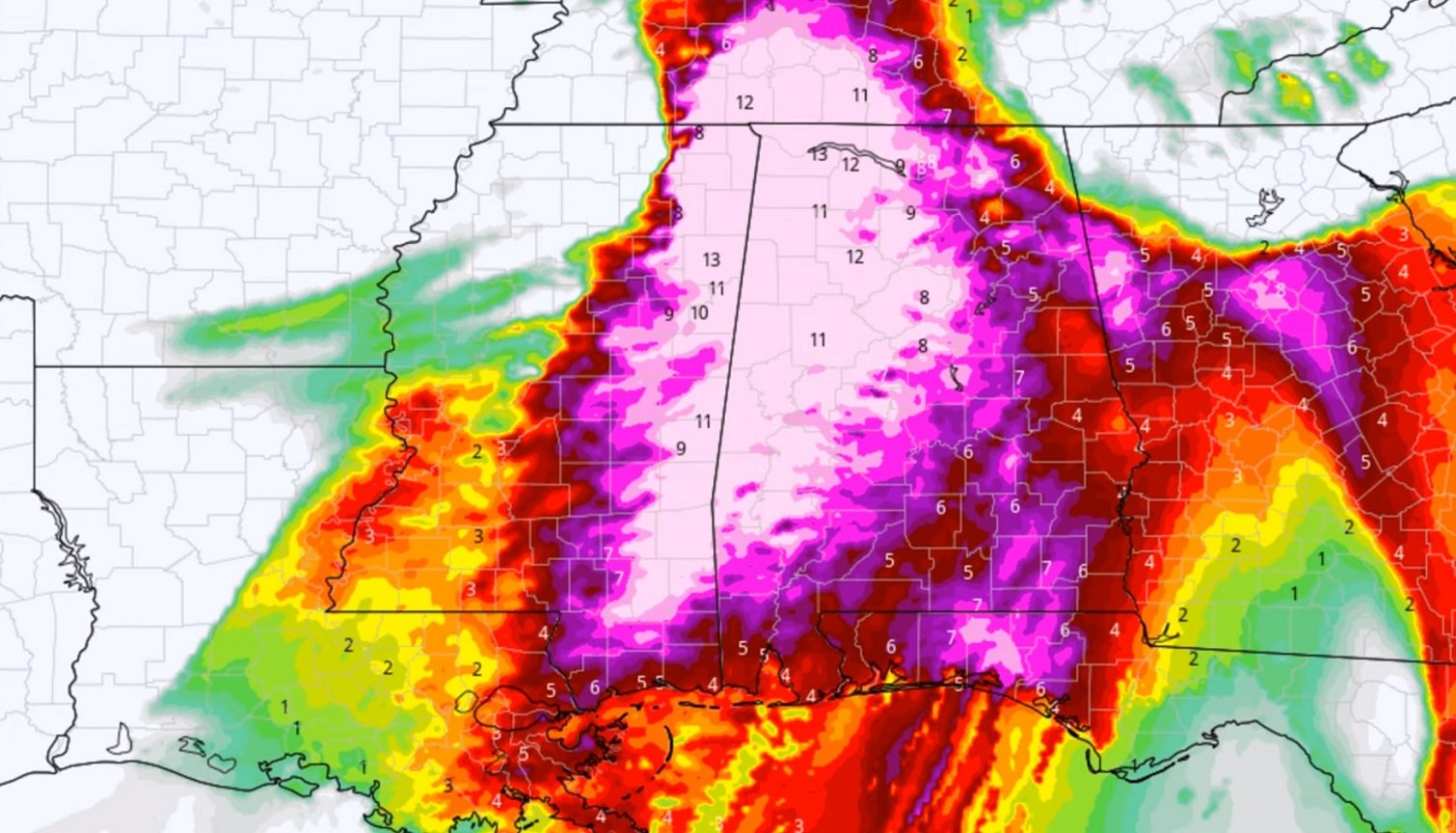
My overall concern for this event continues to grow. I know the parameters aren't exactly the same, but this is as close to April 27, 2011 as I've seen since April 27, 2011 for MS/AL.
Just look at these STP values and tell me that doesn't bring back memories. Makes me shudder:

I get not wanting to be hyperbolic, but at this point emphatically saying this won't be like April 27, 2011 seems to be borderline irresponsible, no? And let's not forget this event looks like there will be prior convection. Some of the radar loops look eerily similar to me showing earlier rounds of convection that we aren't overly concerned about followed by outrageously high STP's later in the day. That is.... exactly what we were staring at on April 27 and the result was absolutely disastrous. The early morning event across Alabama was absolutely underwarned for until the event was occurring. I don't think the atmospheric paramaters were expected to be off the charts that morning (just as they aren't this time around) yet there were still dozens of tornadoes and a vicious line of storms. What is the risk something like that, even on a smaller scale, occurs? I haven't really heard that mentioned at all.
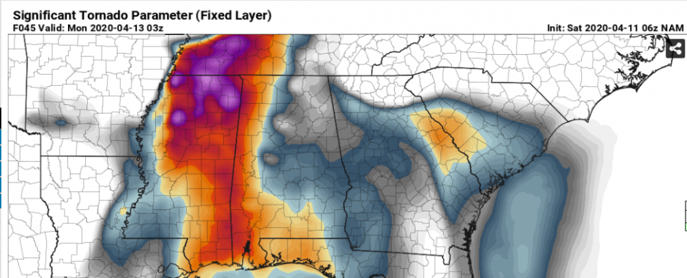
The 6Z NAM SigTor values are no better than half of what was indicated on the 4/27/11 image, so I think that fits with what I am expecting with this system, which is about half of the impact of 4/27....and maybe more impactful for Mississippi than Alabama.


Should 4/12/20 have been a SPC High Risk day??
in Southeastern States
Posted
It has been nearly three weeks now since the Easter tornado outbreak, and I cannot seem to shake the sense that 4/12/20 should have gotten a high risk designation from SPC.
Arguments AGAINST a high risk as it was unfolding: sloppy, wavy warm front with debatable warm sector and jet dynamics not exactly aligned.
Arguments FOR: you could tell that based on the meso discussions, there was a ton of potential for problems and forecasters were using some strong wording about the high potential, but SPC ultimately never pulled the trigger on declaring the high risk. (which should have at least been southern MS and far west AL)
My theory on the lack of trigger pull? Because 5/20/19 in the Midwest was overhyped and ultimately a high risk bust, and it was still fresh on their mind.
So...why does this all matter now? Part of it is forecasting consistency and sensibility (e.g. how do you justify no high risk, yet there were 40 deaths and over 100 tornadoes on 4/12??) and the other part is that we are now 9 years removed from 4/27, and complacency will set in with residentsif they think a tornado threat is just another day in the Southeast.
Love to hear your thoughts!