

dryslot
-
Posts
58,502 -
Joined
-
Last visited
Content Type
Profiles
Blogs
Forums
American Weather
Media Demo
Store
Gallery
Everything posted by dryslot
-
Pretty much been a daily occurrence up there has it not?
-
Tis the currier & ives season so bring on the mood flakes.
-
Heck if we can't live at 500mb, That would be my 2nd choice.
-
Would probably end up with minimal loss to what they already had.
-
They have quite a pack up there, They should be ok.
-
It is what it is, There going to take a hit up north as well.
-
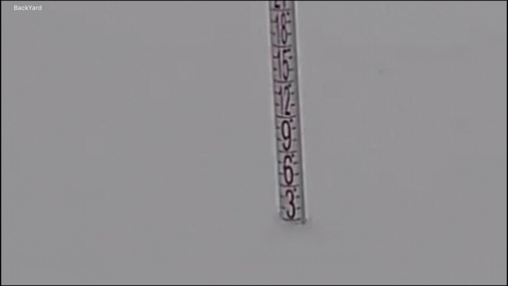
Looks like we picked up another 1" in this last batch that's moved thru the last 2 hrs or so, 3", -SN
-
Its where the grinch is buried and is in full resurrection.
-
Radar building again and filling here, Rates have increased some, -SN, 30°F
-
SoPo
-
Talk about a dud storm, 2.0", Radar looks like shi t.
-
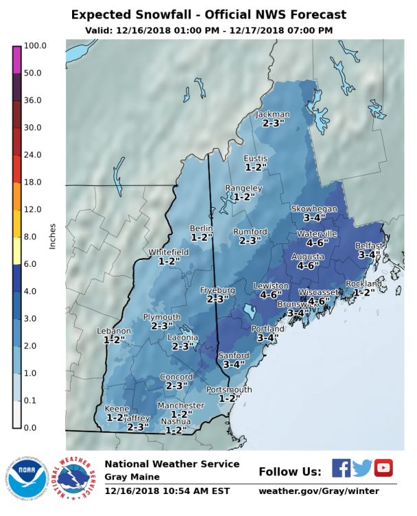
Here you go .NEAR TERM /THROUGH MONDAY/... 730 PM Update... Band of intense precipitation is not moving onshore in southern NH and will eventually lift into coastal Maine tonight. Water vapor imagery shows a large area of cooling cloud tops moving into southern New Hampshire. The band of frontogenetically forced precipitation is moving quickly and have opted to move the advisory time up for southeastern NH and southern Maine to 10 PM as opposed to midnight. By then accumulations will have already started. Dew points in the mid to upper 20s leave room for wet bulb cooling, and although many spots may start out as rain they will change to a wintry mix or snow. Merrimack and Belknap were also added to the advisory. After retooling the PoPs and snowfall amounts to match a blend of the latest HRRR/RAP13/ NamNest...more than half of these counties may receive 3" of snow with a trace of ice.
-
Overcast, 31/26ºF
-
Yup, You could see the radar transitioning from that showery look from earlier as low pressure intensifies.
-
Radar has that thumping appeal.
-
Yup, Probably right around 5" here
-
Overcast 35/27°F
-
When they track NE from 41/70 its a..............
-
We snow
-
Here is what 12z Nam had for qpf, Whether its right or not
-
Tough to believe the Nam although the 06z Euro bumped qpf a little up here too.
-
Post christmas is the first big one for the northeast, Right before the new year.
-
It is better then nothing, Nice refresher.
-
Seeing it only affects 3 or 4 people speaks volumes.
-
A general 1-3” looks in the cards for up here more as you head Doneast.


