

cheese007
-
Posts
1,580 -
Joined
-
Last visited
Content Type
Profiles
Blogs
Forums
American Weather
Media Demo
Store
Gallery
Posts posted by cheese007
-
-
First tor watch out for the day with 40/20 probs
SEL0 URGENT - IMMEDIATE BROADCAST REQUESTED Tornado Watch Number 110 NWS Storm Prediction Center Norman OK 230 PM CDT Mon Apr 15 2024 The NWS Storm Prediction Center has issued a * Tornado Watch for portions of Southwest Oklahoma Northwest Texas * Effective this Monday afternoon and evening from 230 PM until 900 PM CDT. * Primary threats include... A couple tornadoes possible Scattered large hail and isolated very large hail events to 3 inches in diameter likely Scattered damaging winds and isolated significant gusts to 75 mph possible SUMMARY...Severe thunderstorms are expected to develop in the next 1 to 2 hours across northwest Texas and shift east through early evening. Large hail and damaging gusts are possible initially, with an increasing tornado risk expected during the evening. The tornado watch area is approximately along and 70 statute miles east and west of a line from 40 miles west southwest of San Angelo TX to 50 miles northwest of Wichita Falls TX. For a complete depiction of the watch see the associated watch outline update (WOUS64 KWNS WOU0). PRECAUTIONARY/PREPAREDNESS ACTIONS... REMEMBER...A Tornado Watch means conditions are favorable for tornadoes and severe thunderstorms in and close to the watch area. Persons in these areas should be on the lookout for threatening weather conditions and listen for later statements and possible warnings. && OTHER WATCH INFORMATION...CONTINUE...WW 109... AVIATION...Tornadoes and a few severe thunderstorms with hail surface and aloft to 3 inches. Extreme turbulence and surface wind gusts to 65 knots. A few cumulonimbi with maximum tops to 500. Mean storm motion vector 24035. ...Leitman -
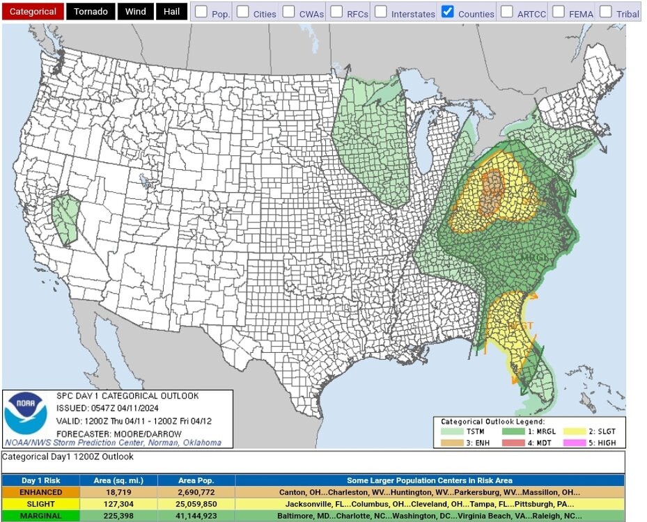
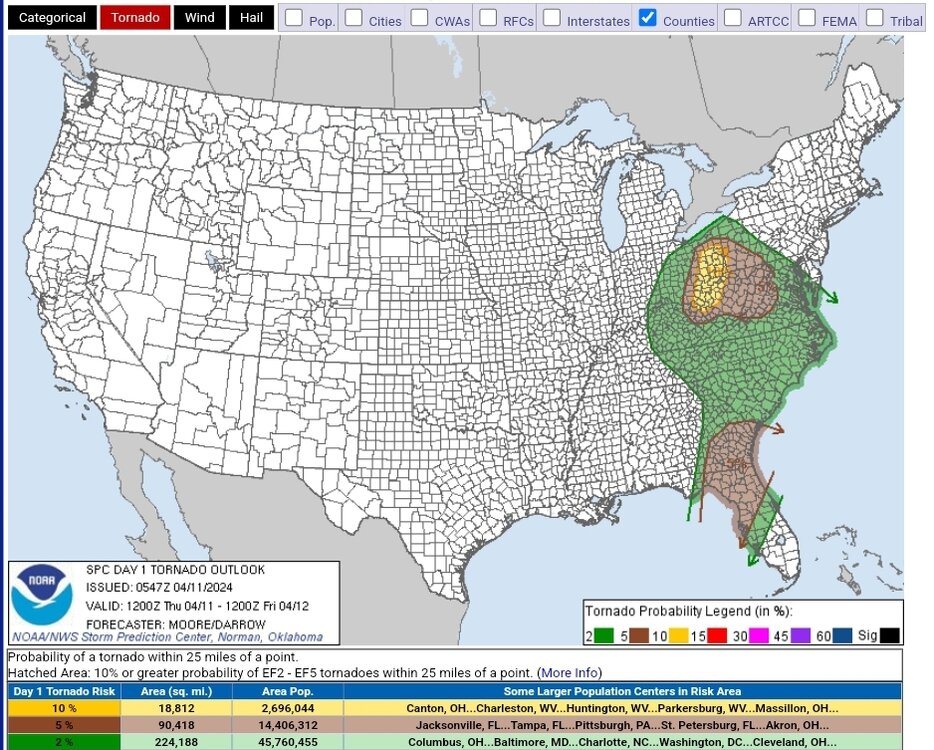
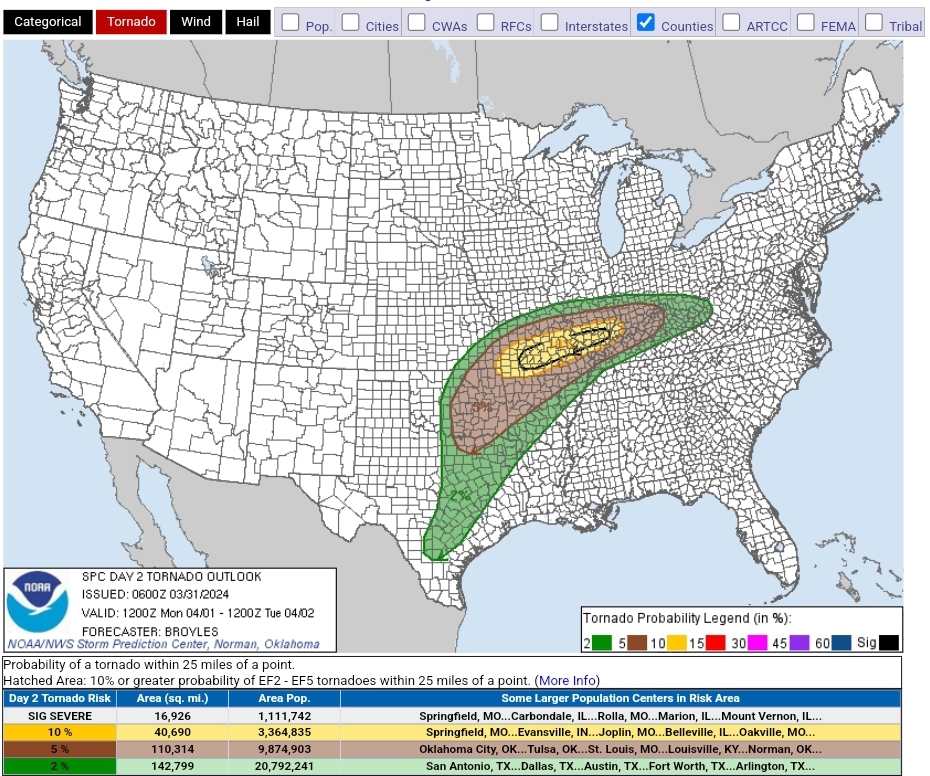
Final day of this multi-day event brings an ENH risk with 10% Tor probs covering southeast OH and the edges of surrounding states
-
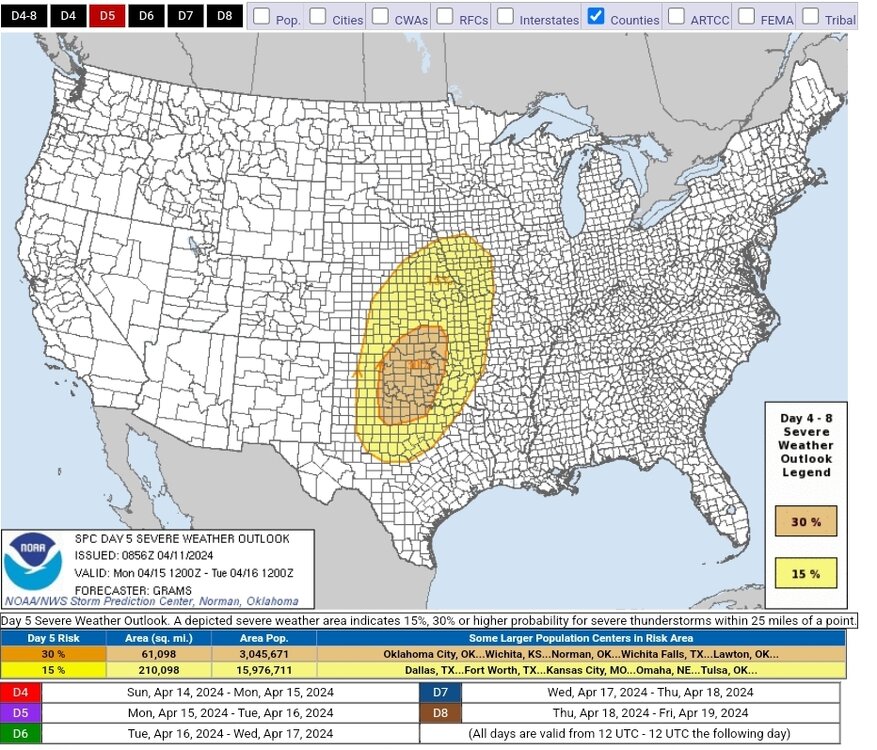
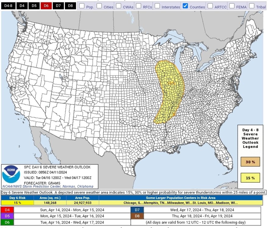
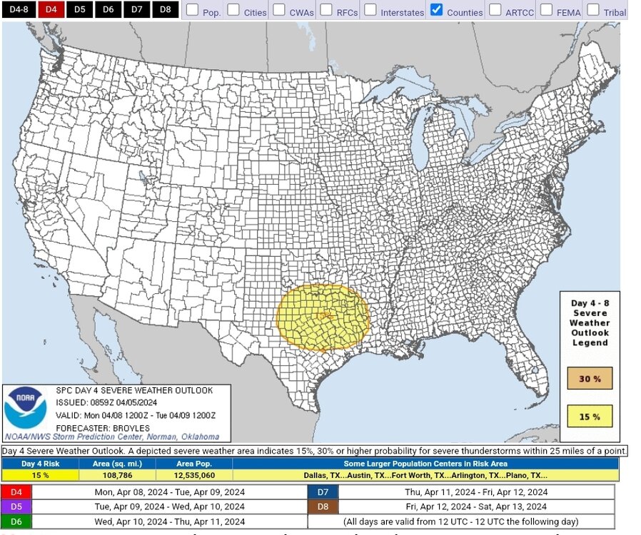
30% contour expanded for D5 with an addition of a 15% contour on D6. Pretty strong wording in the latest discussion text:
ZCZC SPCSWOD48 ALL ACUS48 KWNS 110856 SPC AC 110856 Day 4-8 Convective Outlook NWS Storm Prediction Center Norman OK 0356 AM CDT Thu Apr 11 2024 Valid 141200Z - 191200Z ...DISCUSSION... ...Significant severe weather episode possible late afternoon and evening on Monday... A mid/upper low over the central CA vicinity at 12Z Sunday should evolve into an open wave as it ejects across the Southwest and into the central Great Plains by around Tuesday morning. As it crosses the Rockies onto the High Plains, the tropospheric flow field will amplify with substantial lee cyclogenesis in the central High Plains on Monday afternoon. While a moderate amount of spread persists across respective ensemble systems, 00Z deterministic runs have converged towards greater agreement with the aforementioned scenario through D5, with progressively lower predictability in D6-8. With about 3 days of persistent low-level moisture modification from the western Gulf beneath an extensive elevated mixed layer, the northern extent of mid 60s surface dew points should reach into most of OK east of the dryline by Monday afternoon. Late afternoon thunderstorm initiation along the dryline appears probable in the eastern TX Panhandle/western north TX to western OK vicinity, within a kinematic and thermodynamic profile favorable for strong supercells. Convective development will blossom both south and especially north extent during the evening across the central and southern Great Plains. For this outlook, have expanded the 30 percent area to highlight the greater spatial confidence in a substantial severe weather episode. Despite increasing predictability concerns and the impact of prior day convection, very strong flow fields should persist into at least the first half of D6/Tuesday as a deep surface cyclone pivots northeast towards the Upper MS Valley vicinity. While instability will be weaker compared to Monday, organized severe potential is evident within an arc from a portion of the Upper MS Valley to the Mid-South. In the wake of this lead system, the shortwave trough digging into the Pacific Northwest may carve out a broad, positive-tilt trough in the West by mid-week. Consensus of guidance suggests that rich low-level moisture over the southern Great Plains will not be scoured by the lead wave. This may yield daily bouts of severe thunderstorms across parts of the central and southern Great Plains late in the period and beyond. Predictability for individual day highlights is too low to warrant 15 percent probabilities yet. ..Grams.. 04/11/2024
-
 3
3
-
 1
1
-
-
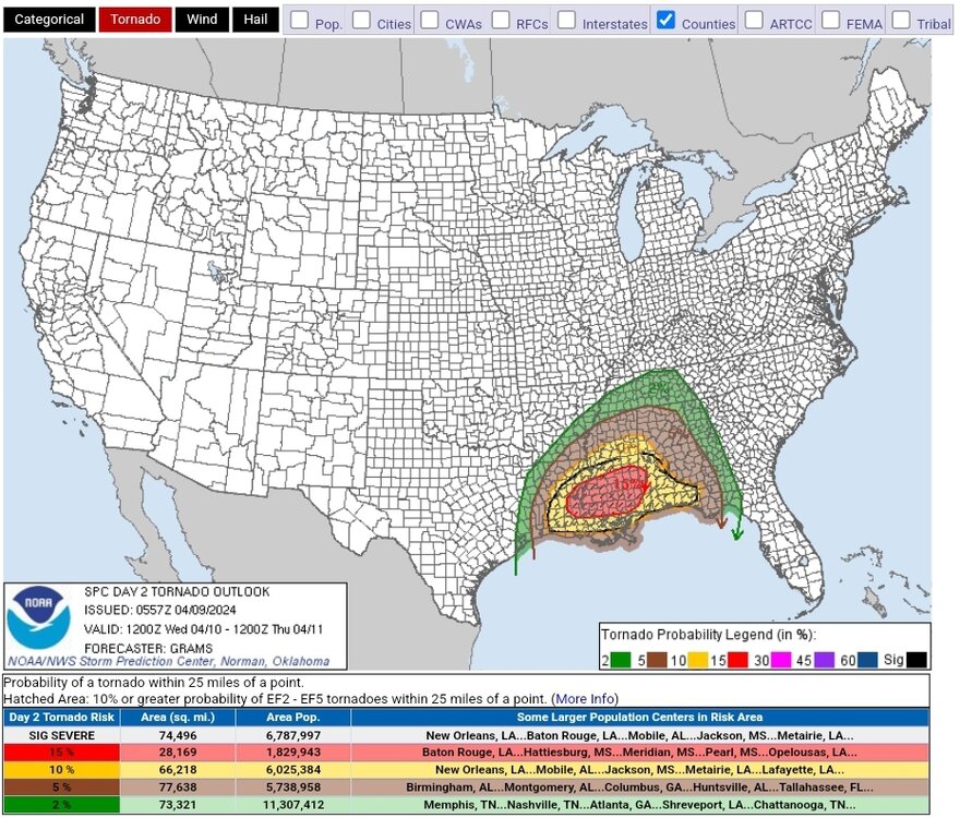
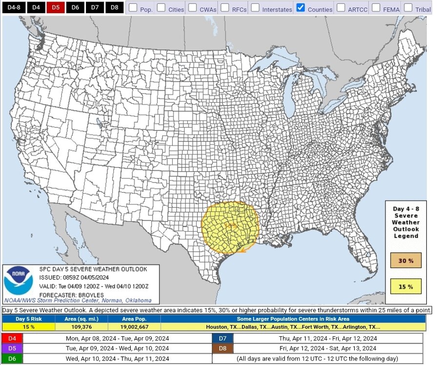
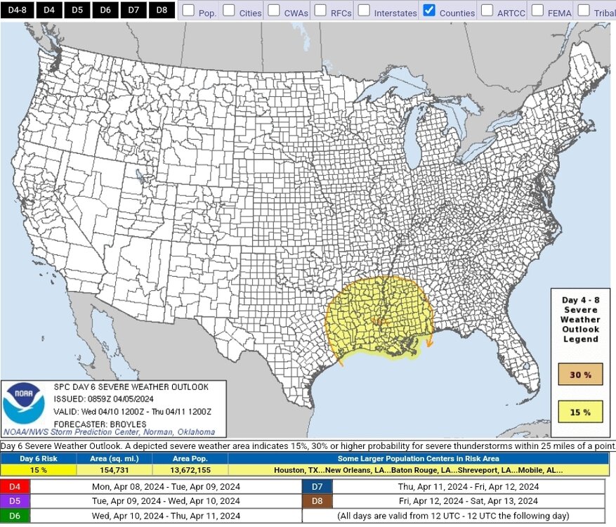
D6 30% out extending from the Wichita Fallas area far south-centeal Kansas. SPC has also outlined a huge 15% area covering varying parts of AR/IA/KS/MO/NE/TX
-
1
-
-
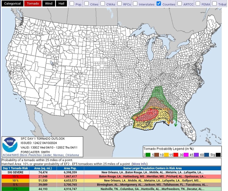
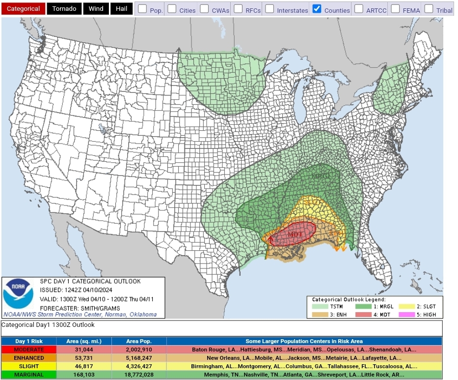
D1 hatched mod risk with an ongoing tor watch at 70/50 probs covering Baton Rouge and New Orleans
SEL1 URGENT - IMMEDIATE BROADCAST REQUESTED Tornado Watch Number 101 NWS Storm Prediction Center Norman OK 600 AM CDT Wed Apr 10 2024 The NWS Storm Prediction Center has issued a * Tornado Watch for portions of Southeast Louisiana Central and Southern Mississippi Coastal Waters * Effective this Wednesday morning and afternoon from 600 AM until 100 PM CDT. * Primary threats include... A few tornadoes likely with a couple intense tornadoes possible Widespread damaging winds and isolated significant gusts to 80 mph likely Scattered large hail events to 1.5 inches in diameter possible SUMMARY...A destabilizing airmass across the central Gulf Coast will support an increasing severe thunderstorm and tornado risk this morning into the midday. The tornado risk will likely maximize with any supercells that develop within the warm sector as the marine warm front advances northward. A squall line will move west to east across the area with a risk for damaging gusts and the tornado risk will likely focus with any sustained mesovortex or embedded supercell. The tornado watch area is approximately along and 85 statute miles east and west of a line from 95 miles northwest of Meridian MS to 45 miles west southwest of Boothville LA. For a complete depiction of the watch see the associated watch outline update (WOUS64 KWNS WOU1). PRECAUTIONARY/PREPAREDNESS ACTIONS... REMEMBER...A Tornado Watch means conditions are favorable for tornadoes and severe thunderstorms in and close to the watch area. Persons in these areas should be on the lookout for threatening weather conditions and listen for later statements and possible warnings. && OTHER WATCH INFORMATION...CONTINUE...WW 99...WW 100... AVIATION...Tornadoes and a few severe thunderstorms with hail surface and aloft to 1.5 inches. Extreme turbulence and surface wind gusts to 70 knots. A few cumulonimbi with maximum tops to 500. Mean storm motion vector 25040. ...Smith
-
D1 ENH with a 10% sigtor and D2 MOD with a 15% sigtor hatch. D3 has two discrete SLGT areas, one strecthing from KY into far western PA and the other from the FL panhandle into NC


-
Apparently looking at a three day event over much the same area with all hazards possible
-
1
-
-
Looking more and more like Monday in TX will be more noteable for severe potential than eclipse visibility


-
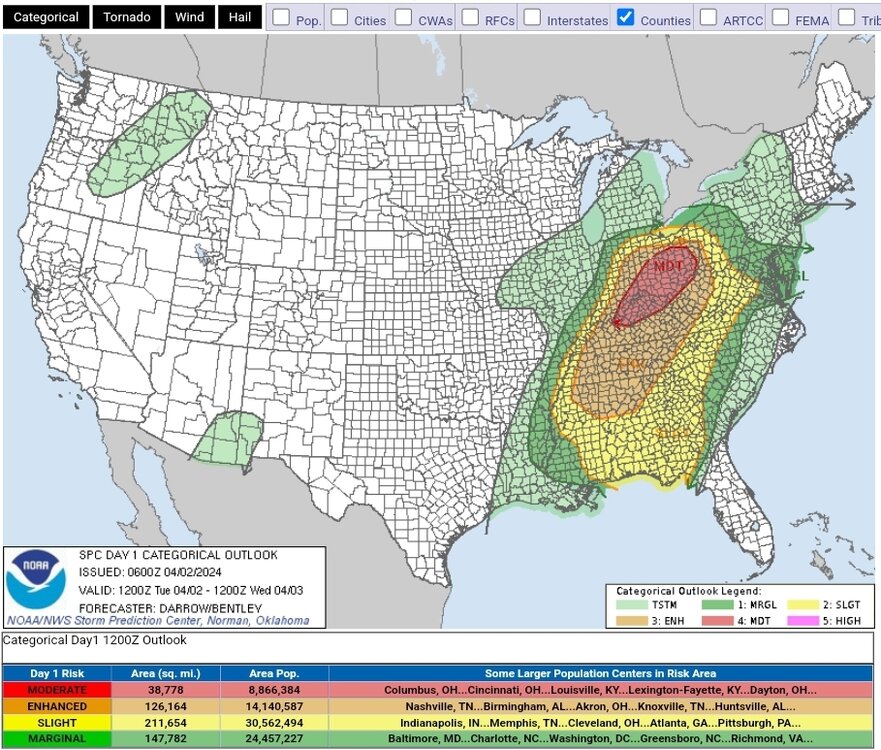
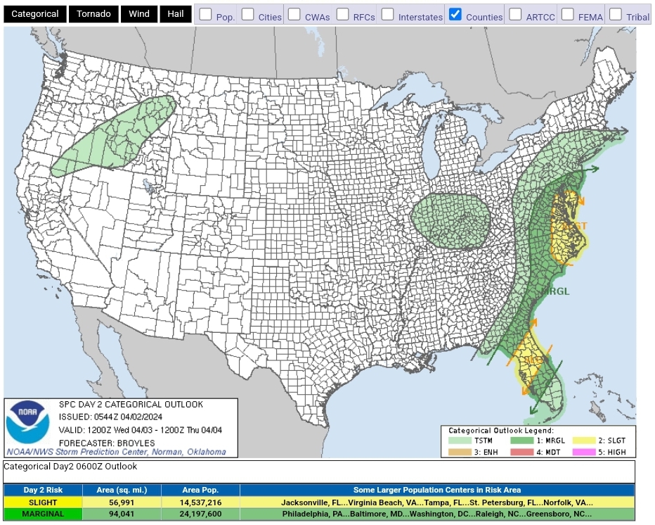
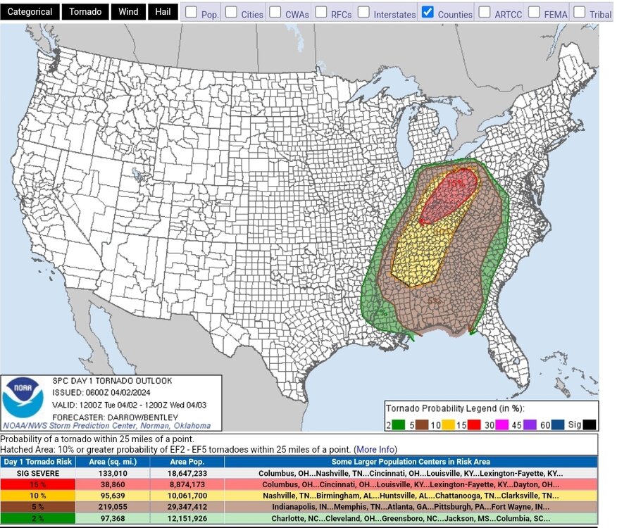
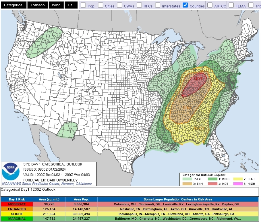
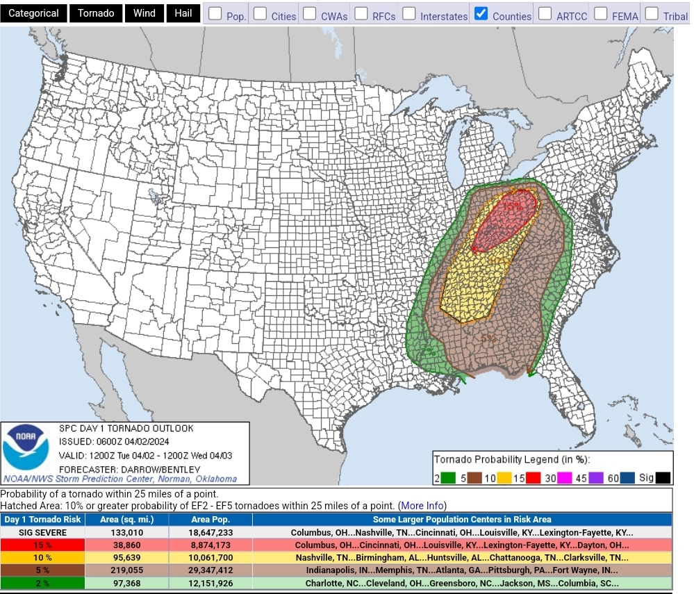
Ohio Valley under the gun today with a big 15% sigtor hatched risk. D2 also has a slight risk for parts of FL and the mid-Atlantic
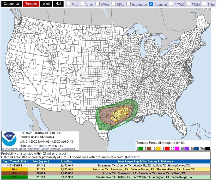
SPC AC 020600 Day 1 Convective Outlook NWS Storm Prediction Center Norman OK 0100 AM CDT Tue Apr 02 2024 Valid 021200Z - 031200Z ...THERE IS A MODERATE RISK OF SEVERE THUNDERSTORMS ACROSS THE OHIO VALLEY... ...SUMMARY... A potentially substantial severe weather outbreak -- possibly including a few significant/long-track tornadoes -- is anticipated this afternoon and evening, with the highest probability centered over the Ohio Valley. Severe risk exists as far south as the Gulf Coast, and as far east as western portions of Virginia and the Carolinas. ...Discussion... Strong northern-stream upper low, currently located over southern MB, is forecast to drop south across MN into northern IL late in the period. This evolution is driven in part by a 500mb speed max that will translate across the central Plains, increasing to near 100kt over eastern KS/OK by 03/12z. Intense 12hr midlevel height falls are forecast across much of the Great Lakes, OH/TN Valley, and the northern Gulf States, where values in excess of 200m are expected during the latter half of the period. Synoptic front that is currently draped across the OH Valley will be encouraged to gradually advance north due to the digging trough; however, an extensive corridor of convection currently extends across the MS Valley into the OH valley, which is maintaining cool boundary-layer conditions north of I-70. Latest water-vapor imagery suggests a southern-stream short-wave trough is progressing across eastern KS/eastern OK. This feature will progress downstream and likely aid early-day thunderstorm development near the confluence of the MS/OH Rivers. Seasonally high PW airmass currently extends across northern AR/southern MO into southern IL. NAM forecast sounding for JBR at 15z exhibits 60kt surface-6km bulk shear with SBCAPE on the order of 1500 J/kg. Discrete supercells may evolve ahead of this feature then spread/develop northeast across southern IN/KY into OH. Some uncertainty exists across northern OH/IN regarding destabilization. It's not entirely clear if ongoing convection will allow the warm front to lift appreciably north of its current position. However, large-scale pattern is quite dynamic and favors surface low deepening over southern Lake MI during the latter half of the pattern. NAM struggles to reflect this scenario, thus weaker instability is forecast at higher latitudes. Tornadoes, damaging winds, and large hail are expected with supercells that evolve across the warm sector. Some tornadoes may be long-lived and strong. Farther south, a bimodal severe threat may ultimately evolve with a secondary corridor of more concentrated severe across portions of the northern Gulf States. 500mb speed max is forecast to eject across northern Mexico into TX by 03/00z. This feature will intensify as it translates across LA into eastern TN by the end of the period. There is some concern that severe probabilities may need to be increased across this region to account for this low-latitude speed max during the evening/overnight hours. Strong shear will support supercells along with a threat for tornadoes, damaging winds, and hail. ..Darrow/Bentley.. 04/02/2024
-
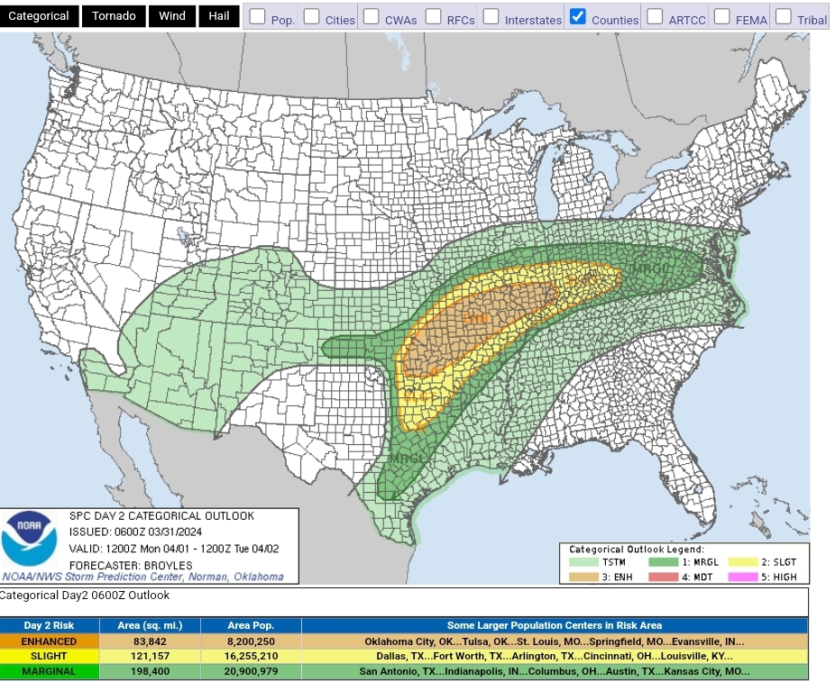
Slight added for D1 with D2 and D3 sitting at ENH as of this morning. D2 adds a sigtor countour for much of southern MO into IL

-
1
-
-
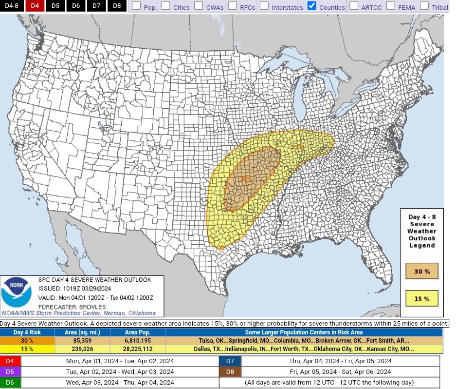
Monday got part of the risk area bumped to 30% in the D4, primary threat being hail but tornadoes and strong winds also likely

-
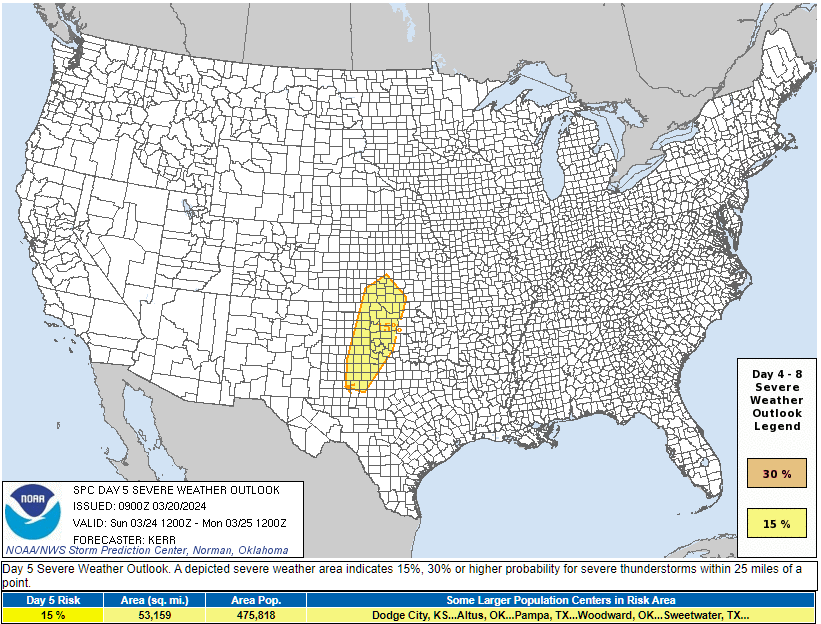
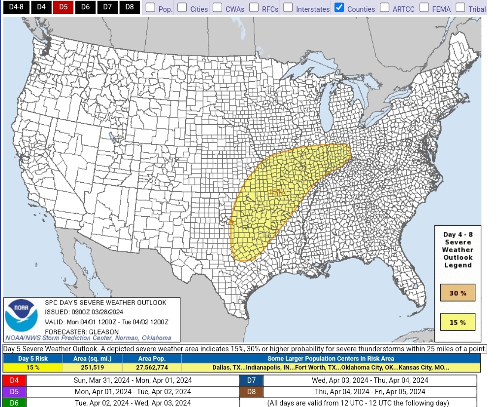
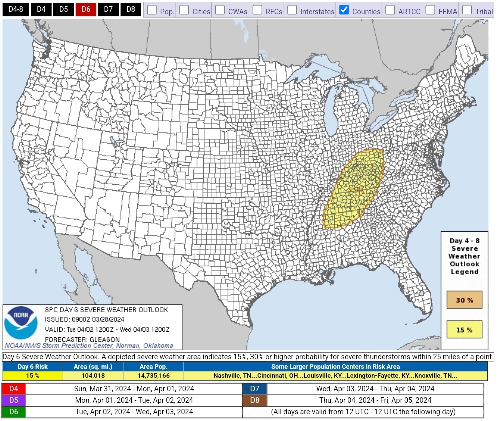
Another early week system with a big D5 15% and a D6 15% for outside this subforum.
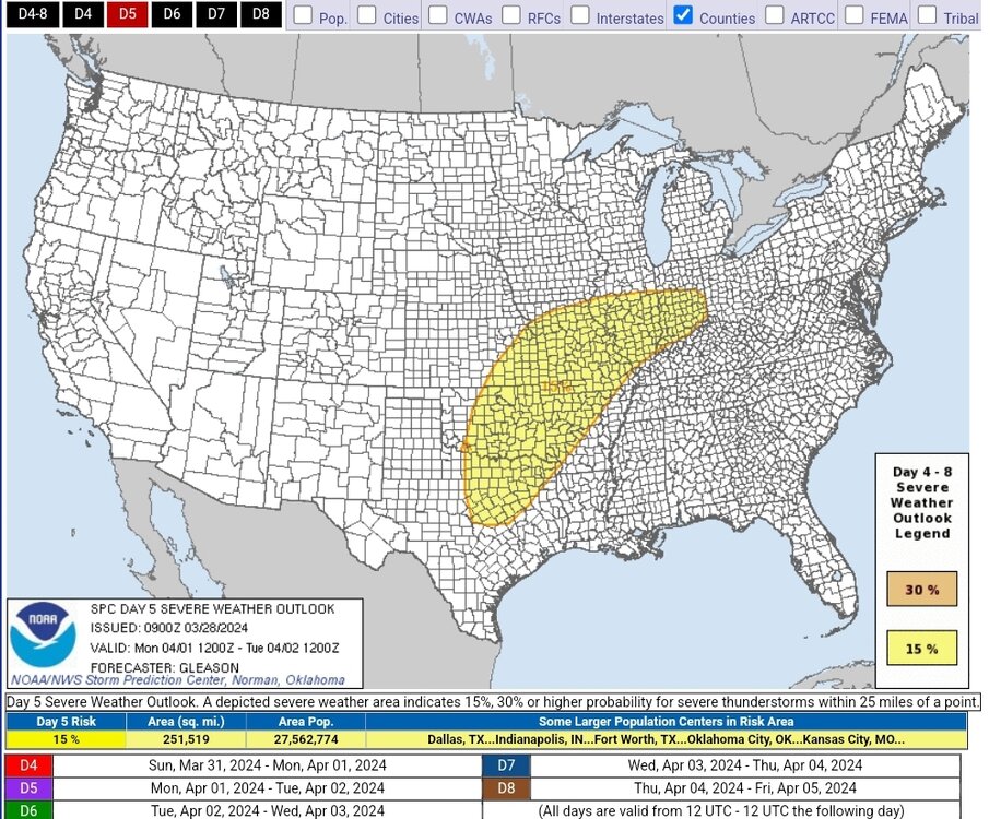

ZCZC SPCSWOD48 ALL ACUS48 KWNS 280900 SPC AC 280900 Day 4-8 Convective Outlook NWS Storm Prediction Center Norman OK 0400 AM CDT Thu Mar 28 2024 Valid 311200Z - 051200Z ...DISCUSSION... ...Day 4/Sunday: Mid Mississippi Valley into the Central/Southern Plains... The upper trough/low over the western states should slowly advance eastward towards the Southwest and southern/central High Plains on Sunday. Upper ridging is forecast to remain over the central/ southern Plains through Sunday night, which in tandem with a low-level temperature inversion should tend to suppress most convection. One possible exception may be along a sharpening warm front across MO/IL, where some guidance suggests elevated convection may form either Sunday morning, and/or Sunday night with strong low-level warm advection/lift occurring. Steepening mid-level lapse rates are forecast to overspread the mid MS Valley from the southwest through the period. These lapse rates, along with increasing moisture/instability in the presence of strong deep-layer shear, may support a risk for isolated supercells with associated threat for large hail. Regardless, confidence remains too low in this mainly elevated convection occurring, given upper ridging persisting, to add a 15% severe area for Sunday along/near the warm front in MO/IL at this time. ...Day 5/Monday: Southern/Central Plains into the Mid Mississippi and Ohio Valleys... Even though some differences remain in medium-range guidance regarding the ejection of an upper trough over the central CONUS on Monday, confidence has increased in the general location of relevant surface features, including the primary low, position of a southward-extending dryline, and northward extent of the warm front into the OH Valley. Even though the overall upper trough orientation may remain somewhat positively tilted, most deterministic guidance shows that a mid-level speed max and associated shortwave trough will eject northeastward over the southern/central Plains through Monday evening. Low-level mass response should encourage the eastward development of a surface low to the OK/KS vicinity in a similar time frame. Favorable low-level trajectories emanating from the Gulf will act to increase low-level moisture in tandem with steepening mid-level lapse rates and daytime heating across a broad warm sector extending from the southern/central Plains into the lower/mid MS Valley and OH Valley. A favorable thermodynamic and kinematic environment for organized severe convection will exist across much of these regions, with supercells capable of producing large hail and tornadoes possible initially. With time Monday evening/night, some upscale growth seems probable across the mid MS and OH Valleys, as mid-level flow should become increasingly parallel to a surface cold front. Therefore, a 15% severe area has been introduced for Monday where confidence is greatest that robust convection will develop in a parameter space characterized by weak/moderate instability and strong deep-layer shear. A nocturnal minimum in severe convective potential may be realized Monday night into early Tuesday morning across parts of the lower MS Valley into Mid-South, given the positively tilted nature of the upper trough. ...Day 6/Tuesday: Ohio/Tennessee Valleys into the Appalachians... Some severe threat should continue Tuesday over parts of the OH/TN Valleys into the Appalachians as the upper trough continues eastward. Even though there is still some uncertainty with the exact placement of the primary surface low and evolution of the upper trough, enough confidence exists in a fairly narrow corridor across these regions to add a 15% severe area for Tuesday. Rich low-level moisture should be in place ahead of an eastward-moving cold front. Redevelopment and/or re-intensification of convection seems probable by Tuesday afternoon. Strong deep-layer shear and weak instability should be sufficient for organized severe convection posing some threat for damaging winds, and perhaps tornadoes given the forecast strength of a low-level jet focused over parts of the OH/TN Valleys. The northward extent of the severe risk across OH and vicinity remains uncertain, as the placement of the warm front varies in model guidance. Similarly, convection should eventually encounter a less unstable airmass across the Appalachians. But, an isolated severe risk may continue Tuesday evening into early Wednesday morning across the southern/central Appalachians into portions of the Southeast. ...Day 7/Wednesday and Day 8/Thursday... Predictability remains too low to include a 15% severe delineation for Wednesday across the Mid-Atlantic/Southeast along/ahead of a cold front. By this extended time frame, there are significant differences in model guidance regarding the evolution of the upper trough, including its possible interaction/merging with a northern-stream trough, and placement of relevant surface features. Still, at least an isolated severe risk may persist Wednesday along/ahead of the eastward-sweeping cold front. Once this front clears the East Coast, severe potential appears minimal across the CONUS next Thursday. ..Gleason.. 03/28/2024 CLICK TO GET WUUS48 PTSD48 PRODUCT
-
1
-
1
-
-
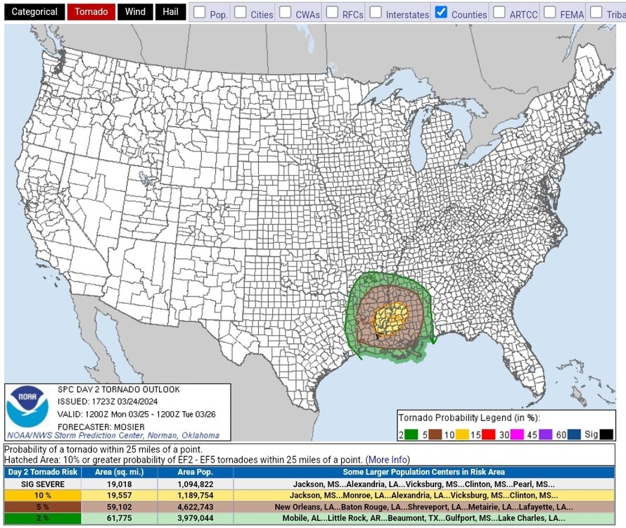
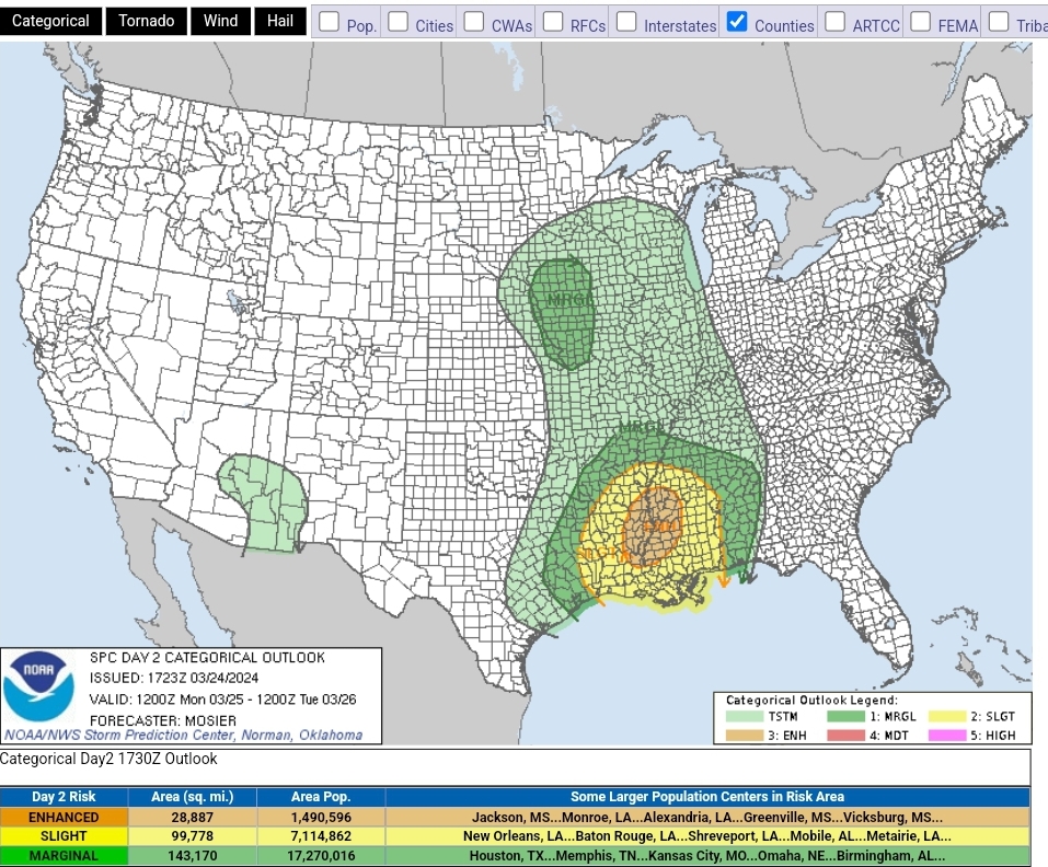
D2 ENH with Sigtor hatch
SPC AC 241723 Day 2 Convective Outlook NWS Storm Prediction Center Norman OK 1223 PM CDT Sun Mar 24 2024 Valid 251200Z - 261200Z ...THERE IS AN ENHANCED RISK OF SEVERE THUNDERSTORMS ACROSS PORTIONS OF THE LOWER MISSISSIPPI VALLEY... ...SUMMARY... Severe thunderstorms with a threat for a few tornadoes and damaging winds are possible Monday through Monday night from parts of east Texas through the Lower Mississippi Valley. ...Synopsis... Deep upper troughing is forecast to be in place across the central CONUS early Monday morning. Several shortwave troughs will be embedded within this large parent upper troughing, including one over the Mid MO Valley and another over the southern High Plains. The northern shortwave is forecast to continue northward through the Upper MS Valley while the southern shortwave moves quickly northeastward across eastern OK/northeast TX and into the Mid MS Valley. Evolution of these shortwaves, in particularly the southern High Plains shortwave, will induce a more negative tilt to the parent upper trough as the entire system gradually shifts eastward. The surface pattern early Monday morning will be complicated by an ongoing convective line across TX, but the general expectation is for a low to be over central KS with the primary cold front extending southwest from this low across the TX Panhandle into northeast NM. A secondary cold front/dry line will also extend southward from this low across central OK and north TX into the TX Hill Country. Showers and thunderstorms will likely be ongoing along an outflow boundary preceding this secondary cold front/dry line from southwest MO through western AR and northeast TX. The cold fronts and convective line are all forecast to progress eastward throughout the day, with some intensification of the convective line possible as it interacts with the greater low-level moisture over the Lower MS Valley. Thunderstorm development is also expected farther north across western IA as the primary surface low moves through during the afternoon. ...Mid-South into the Lower MS Valley... Favorable low-level moisture will exist ahead on the convective line expected to be ongoing early Monday from southwest MO through northeast TX, contributing to modest buoyancy despite widespread cloud cover and relatively cool surface temperatures. Generally modest convection will likely be ongoing within this line early Monday, but the expectation is for the line to reintensify during the early afternoon as large-scale forcing increases, the cold front catches up to the line, and buoyancy reaches its diurnal max. This reintensification will likely begin near the TX/LA border, with storms reaching their maximum intensity across far southeast AR, eastern LA, and western MS. Very impressive wind fields are anticipated across the region, with southeasterly surface winds ahead of the line contributing to large, looping low-level hodographs. Additionally, very strong southwesterly mid-level flow will support a southwesterly deep-layer shear vector with a notable line-perpendicular orientation. Consequently, there is likely a risk for a robust, forward propagating line capable of both strong gusts and embedded QLCS tornadoes. Also, given that the line is expected to be fairly weak at the beginning of the period, there is some chance for more discrete updrafts as the reintensification of the line begins, particularly with southern extent. The airmass will become less unstable with eastward extent into AL, and the expectation is for the overall intensity of the line to weaken as it moves into AL overnight. ...Western Iowa/Far Northwest MO and Vicinity... Within the larger-scale upper trough over the central states, an embedded, cold-core mid-level shortwave trough will move quickly northeastward across the Upper Midwest Monday. Most guidance still shows low 50s surface dewpoints present near a deep surface low across western IA and vicinity Monday afternoon. Given the cold mid-level temperatures, only modest daytime heating is needed for airmass destabilization. Deep-layer shear appears strong enough for a few organized thunderstorms and isolated/marginally severe hail and strong/gusty winds may occur with any sustained low-topped convection. ..Mosier.. 03/24/2024
-
D5 15% contour added covering much of AR/LA/MS as well as the MO bootheel, far western TN, and a smidge of east TX
-
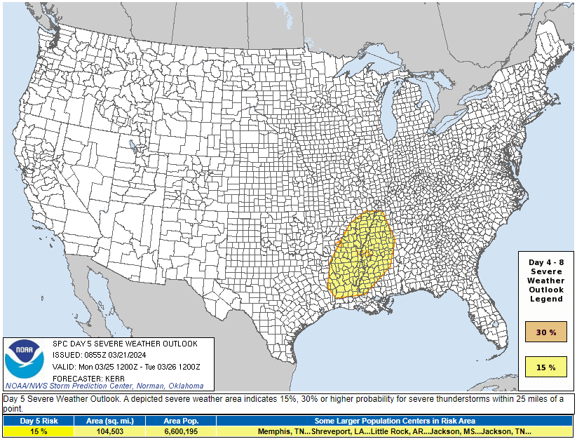
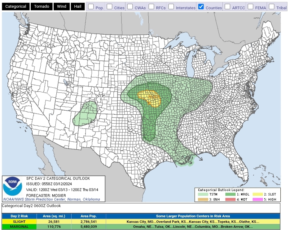
SPC has put out a D5 15% contour with hints at more unsettled weather in the following days
ZCZC SPCSWOD48 ALL ACUS48 KWNS 200900 SPC AC 200900 Day 4-8 Convective Outlook NWS Storm Prediction Center Norman OK 0400 AM CDT Wed Mar 20 2024 Valid 231200Z - 281200Z ...DISCUSSION... Medium-range models suggest that blocking centered over the northeastern Pacific will break down this weekend, as a more progressive regime shifts across the central into eastern mid-latitude Pacific, and gradually inland through much of the U.S. by the middle to latter portion of next week. Initially, flow downstream of the weakening blocking may undergo amplification, including mid-level troughing offshore of the southern Atlantic Seaboard, and larger-scale mid-level troughing progressing inland of the U.S. Pacific coast through the Great Plains and Mississippi Valley through early next week. Within the inland advancing troughing, there appears reasonable agreement between the ECENS/ECMWF, GEFS and GFS model output that a significant lead short wave perturbation will accelerate northeastward out of the Southwest across the southern Rockies late Sunday into Sunday night. As this occurs, a rather deep cyclone is forecast to continue to form to the lee of the Front Range during the day, before migrating southeastward then eastward into the adjacent high plains. Although it still appears that low-level moisture return in the wake of prior low-level drying and cooling across the northern Gulf Basin may still be on the margins for vigorous thunderstorms, the development of steep lower/mid-tropospheric lapse rates may compensate. Coupled with potentially intense wind fields and strong forcing for ascent, organized severe thunderstorm development seems probable late Sunday afternoon into Sunday night. This may include supercells initially, then an evolving narrow squall line. Into the early through middle portion of next week, uncertainties concerning a subsequent short wave emerging from the Southwest increase. However, it appears probable that there will be at least narrow corridors of strong to severe thunderstorm development on following days across the southeastern Great Plains into lower Mississippi Valley and perhaps parts of the Southeast. ..Kerr.. 03/20/2024 CLICK TO GET WUUS48 PTSD48 PRODUCT
-
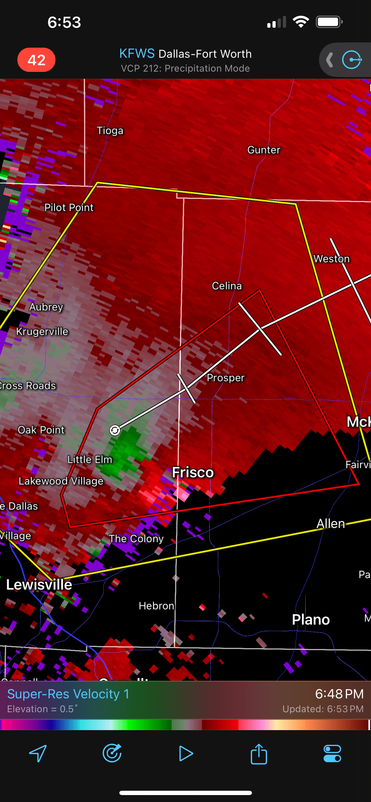
23 hours ago, Sydney Claridge said:
We have a tornado warning in the Frisco, TX area now. Somewhat broad rotation but it bears close watching; the hail is a huge threat regardless of any tornadic activity, though.
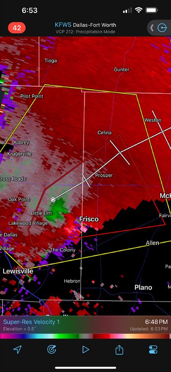
This storm ended up dropping a brief EF-0 over the UNT Frisco parking lot
-
1
-
-
Frisco tor confirmed

-
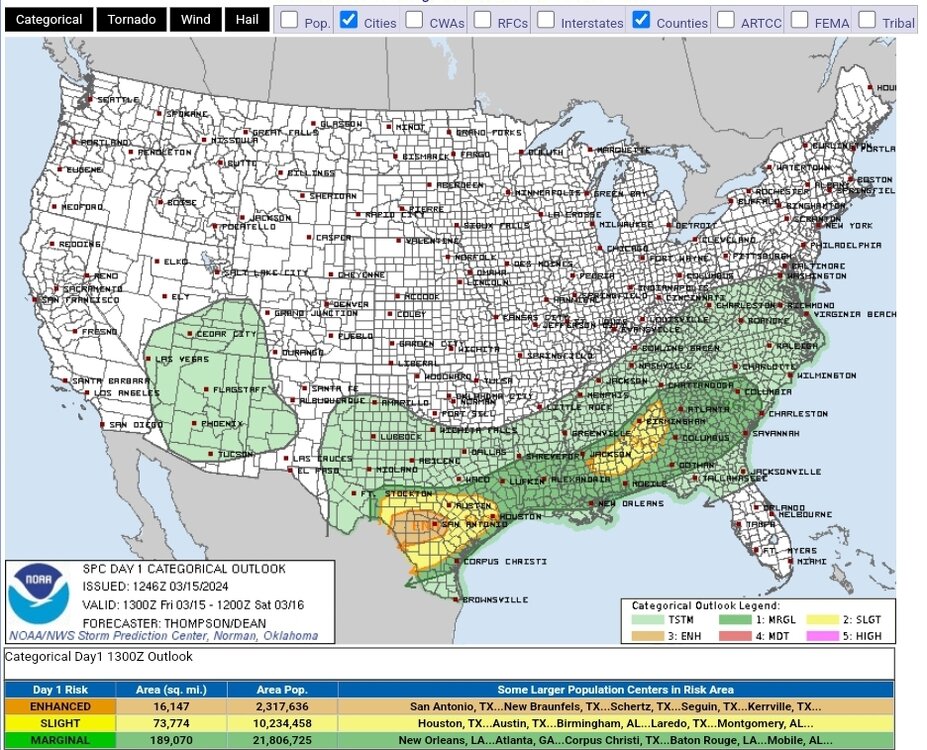
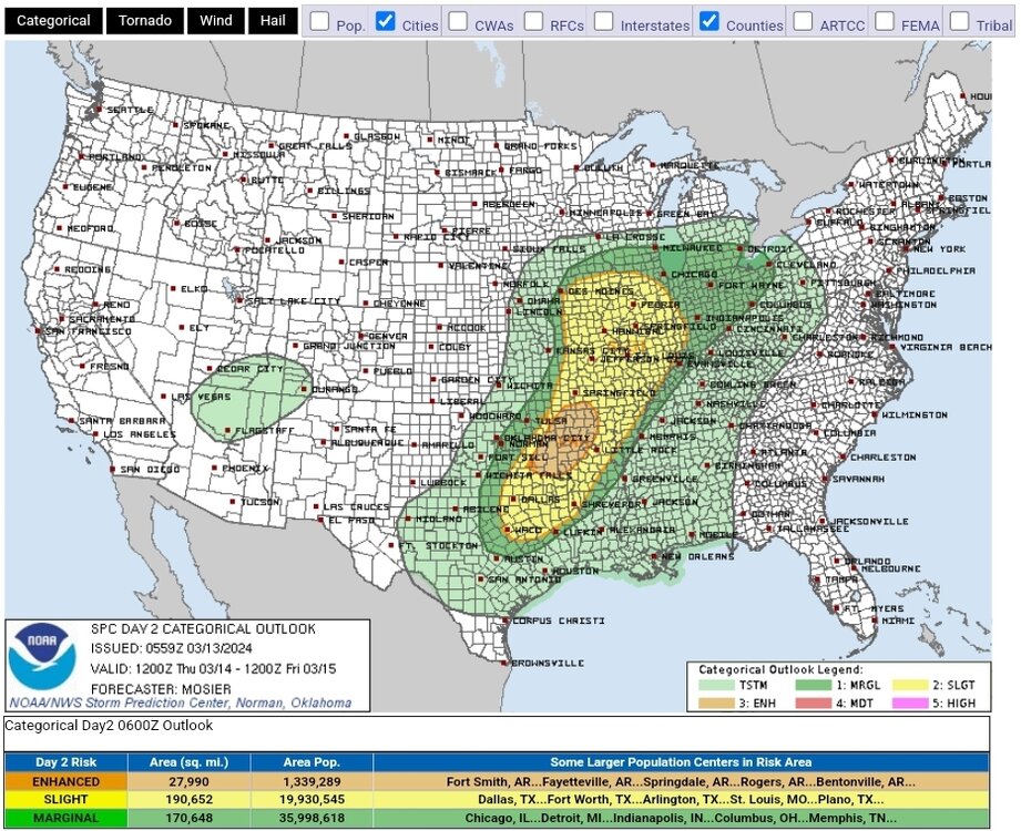
Hail-driven ENH added to the D1
-
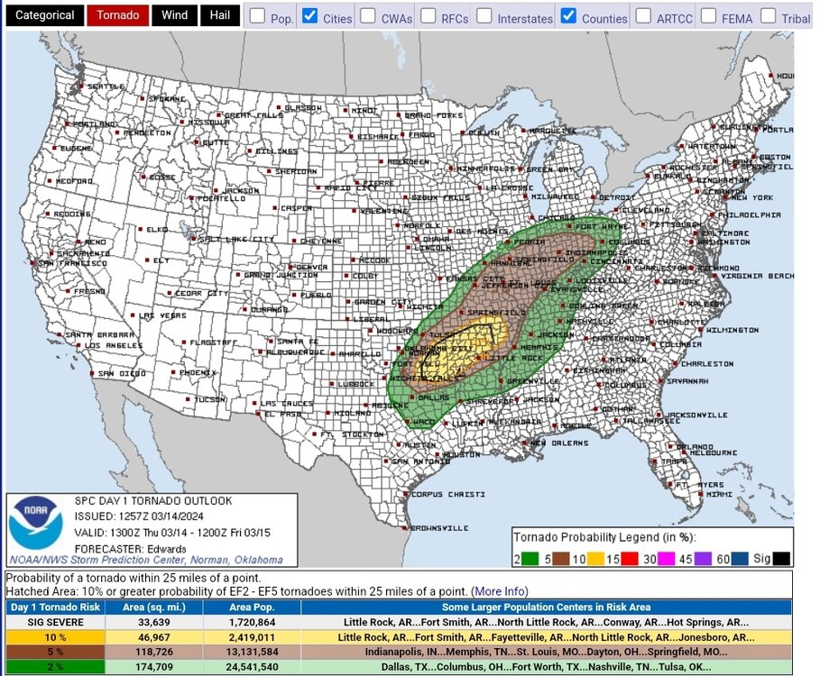
50/30 tor probs URGENT - IMMEDIATE BROADCAST REQUESTED Tornado Watch Number 42 NWS Storm Prediction Center Norman OK 1110 AM CDT Thu Mar 14 2024 The NWS Storm Prediction Center has issued a * Tornado Watch for portions of Central/eastern Oklahoma North-central Texas * Effective this Thursday morning and evening from 1110 AM until 600 PM CDT. * Primary threats include... A few tornadoes and a couple intense tornadoes possible Widespread large hail and scattered very large hail events to 3 inches in diameter likely Scattered damaging wind gusts to 70 mph possible SUMMARY...Supercell thunderstorms will continue to increase in coverage and intensity through the afternoon, while posing a threat for very large hail, severe/damaging winds, and a few tornadoes. The tornado watch area is approximately along and 65 statute miles east and west of a line from 45 miles east northeast of Tulsa OK to 65 miles southwest of Sherman TX. For a complete depiction of the watch see the associated watch outline update (WOUS64 KWNS WOU2). PRECAUTIONARY/PREPAREDNESS ACTIONS... REMEMBER...A Tornado Watch means conditions are favorable for tornadoes and severe thunderstorms in and close to the watch area. Persons in these areas should be on the lookout for threatening weather conditions and listen for later statements and possible warnings. && OTHER WATCH INFORMATION...CONTINUE...WW 40...WW 41... AVIATION...Tornadoes and a few severe thunderstorms with hail surface and aloft to 3 inches. Extreme turbulence and surface wind gusts to 60 knots. A few cumulonimbi with maximum tops to 450. Mean storm motion vector 24035. ...Gleason/Goss-
1
-
-
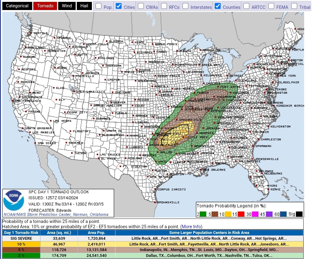
D1 sigtor added
-
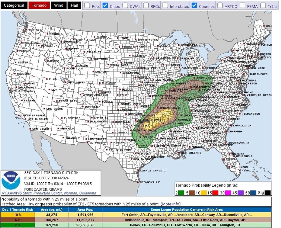
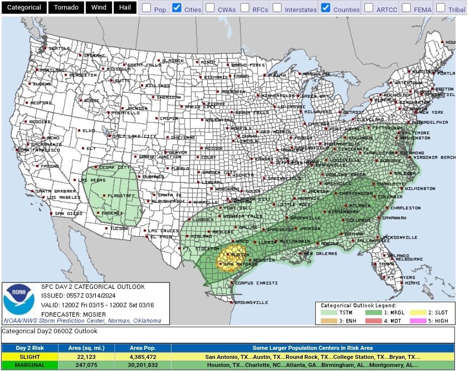
10% tor added for D1 and a slight risk added for Austin/San Antonio area for D2
-
Vince Waelti on YouTube seems to have a good angle
-
ENH added for D1 around KC but no sig-tor hatching as of 8AM
-
1
-
-
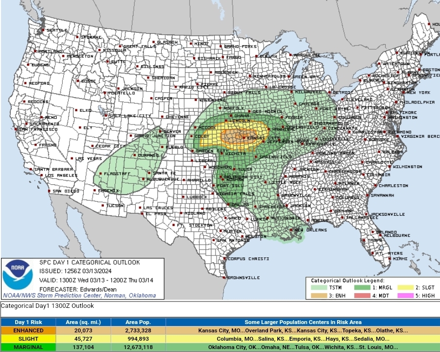
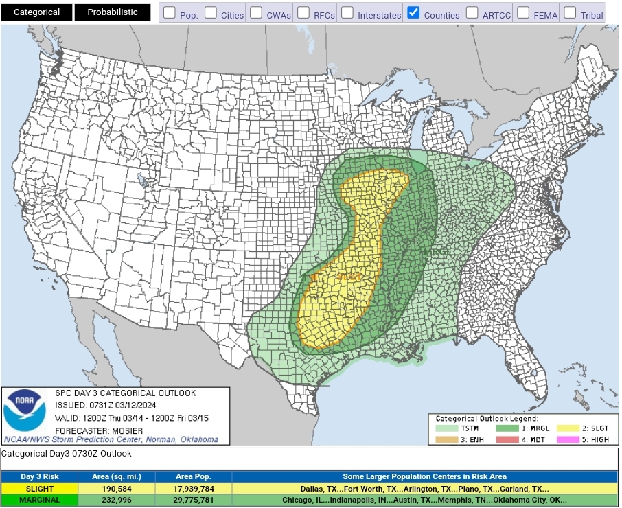
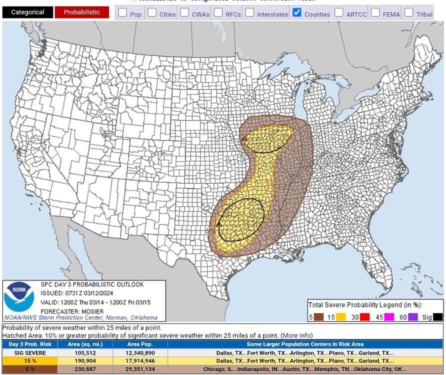
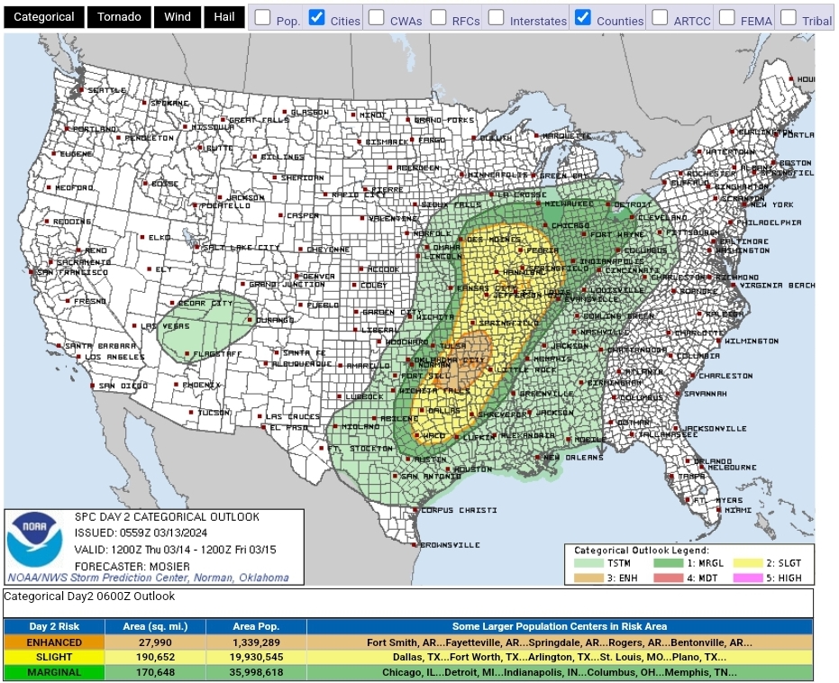
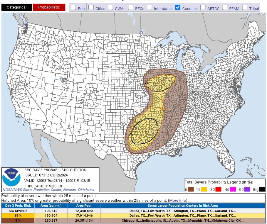
Slight risk added for the 13th as of today, with a large expansion of the risk area + hatching added for the 14th. Below is the discussion for the latter
SPC AC 120731 Day 3 Convective Outlook NWS Storm Prediction Center Norman OK 0231 AM CDT Tue Mar 12 2024 Valid 141200Z - 151200Z ...THERE IS A SLIGHT RISK OF SEVERE THUNDERSTORMS FROM THE MIDDLE MISSISSIPPI VALLEY INTO EASTERN OKLAHOMA...EAST TEXAS...AND THE LOWER MISSISSIPPI VALLEY... ...SUMMARY... Strong to severe thunderstorms are possible across a large area from the Middle Mississippi Valley into eastern Oklahoma, East Texas, and the Lower Mississippi Valley on Thursday. ...Synopsis... A surface low is forecast to be over the NE/IA/MO border vicinity early Thursday morning, with a cold front extending southwestward from this low across eastern KS and central OK into the TX Hill Country. An expansive warm sector is expected to be in place east of this cold front, from the Mid MS Valley into the southern Plains and Lower MS Valley early Thursday morning, supported by the previous days' return flow. Showers and thunderstorms may be ongoing in the vicinity of a warm front extending north-northeastward from the surface low, but much of the warm sector is currently expected to be free from any early period storms. This broad warm sector is expected to destabilize throughout the day with two primary corridors of severe thunderstorms potential, one near the surface low from southern IA/northern MO into west-central IL and another farther south from eastern OK and east TX into LA and AR. ...Southern IA/Northern MO/West-Central IL... Upper 50s dewpoints are expected south of the warm front throughout the period. Despite this somewhat modest low-level moisture, moderate to strong buoyancy is still anticipated early in the afternoon as surface temperatures climb into the low 70s, supported by cold mid-level temperatures and resulting steep mid-level lapse rates. Low-level convergence near the surface low and warm front will likely result in convective initiation amid vertical wind profiles that support supercells. There may be a tendency for storms to move north of the warm front over time, but enough residence in the warm sector is anticipated for some storms to reach maturity. Any mature supercells would be capable of all severe hazards, including tornadoes, strong gusts, and very large hail. ...Eastern OK and East TX into LA and AR... Weak surface troughing will likely interact with an increasingly unstable airmass across the region during the afternoon, with convective initiation anticipated around 18Z across southeast OK and northeast TX. Given robust buoyancy and moderate vertical shear, initial development will likely be supercellular and capable of all severe hazards, including very large hail. How the convection evolves after the initial more discrete storms remains uncertain, with some potential for development into more linear structures given the front-parallel deep-layer vertical shear. If upscale growth is realized, the resulting convective line would then push eastward into AR and LA, with some potential for damaging gusts. ..Mosier.. 03/12/2024


Texas 2024 Discussion/Observations
in Central/Western States
Posted
Tor warned supercell heading towards the Lampasas area
Tornado Warning
TXC281-190000-
/O.NEW.KFWD.TO.W.0005.240418T2319Z-240419T0000Z/

BULLETIN - EAS ACTIVATION REQUESTED
Tornado Warning
National Weather Service Fort Worth TX
619 PM CDT Thu Apr 18 2024

The National Weather Service in Fort Worth has issued a

* Tornado Warning for...
  Southwestern Lampasas County in central Texas...

* Until 700 PM CDT.

* At 618 PM CDT, a severe thunderstorm capable of producing a
  tornado was located 20 miles northwest of Lampasas, moving
  southeast at 10 mph.

  HAZARD...Tornado and golf ball size hail.

  SOURCE...Radar indicated rotation.

  IMPACT...Flying debris will be dangerous to those caught without
           shelter. Mobile homes will be damaged or destroyed.
           Damage to roofs, windows, and vehicles will occur.  Tree
           damage is likely.

* This tornadic thunderstorm will remain over mainly rural areas of
  southwestern Lampasas County, including the following locations...
  Lometa and Nix.

PRECAUTIONARY/PREPAREDNESS ACTIONS...

TAKE COVER NOW! Move to an interior room on the lowest floor of a
sturdy building. Avoid windows. If you are outdoors, in a mobile
home, or in a vehicle, move to the closest substantial shelter and
protect yourself from flying debris.

&&

LAT...LON 3125 9853 3134 9838 3117 9824 3109 9842
TIME...MOT...LOC 2318Z 330DEG 10KT 3127 9842

TORNADO...RADAR INDICATED
MAX HAIL SIZE...1.75 IN

$$

Dunn