AMDEW80
-
Posts
93 -
Joined
-
Last visited
Content Type
Profiles
Blogs
Forums
American Weather
Media Demo
Store
Gallery
Everything posted by AMDEW80
-
December 16 2020 CTP Snowstorm Disco and Obs
AMDEW80 replied to pasnownut's topic in Upstate New York/Pennsylvania
i just got in from playing outside...i'm pretty speechless. maybe the best rates of the day for me...if this band stays over me for awhile my total could be pretty crazy. I have a mountain of snow just from continually shoveling a small path to my wood pile on the patio throughout the day. -
Dec 16-17 Storm OBS Thread
AMDEW80 replied to BuffaloWeather's topic in Upstate New York/Pennsylvania
I'm sitting at the tail end of the band back in pa....crazy! showing no signs of letting up! -
December 16 2020 CTP Snowstorm Disco and Obs
AMDEW80 replied to pasnownut's topic in Upstate New York/Pennsylvania
I have been saying a few times today while looking at the radar "renovo is getting hammered!" my guess is they may take the cake for the highest total. -
December 16 2020 CTP Snowstorm Disco and Obs
AMDEW80 replied to pasnownut's topic in Upstate New York/Pennsylvania
going to be a fun day of playing/cleaning up tomorrow. good times! looking like the band around me is sneaking just a touch north to give me a fantastic finish! -
Dec 16-17 Storm OBS Thread
AMDEW80 replied to BuffaloWeather's topic in Upstate New York/Pennsylvania
enjoy! still coming down hard with 13.5 on the ground here is wellsboro, pa -
December 16 2020 CTP Snowstorm Disco and Obs
AMDEW80 replied to pasnownut's topic in Upstate New York/Pennsylvania
up to 13.5 here.... love this nws grid forecast. Detailed Forecast Tonight Snow. The snow could be heavy at times. Low around 18. Northeast wind around 6 mph. Chance of precipitation is 100%. Total nighttime snow accumulation of 14 to 20 inches possible. Thursday A chance of snow before 1pm. Cloudy, with a high near 26. North wind 3 to 6 mph. Chance of precipitation is 50%. New snow accumulation of less than one inch possible. -
December 16 2020 CTP Snowstorm Disco and Obs
AMDEW80 replied to pasnownut's topic in Upstate New York/Pennsylvania
wowzer, haven't seen snow like this in my 4 years of living here.... up to 9 inches sn+ 19 degrees -
December 16 2020 CTP Snowstorm Disco and Obs
AMDEW80 replied to pasnownut's topic in Upstate New York/Pennsylvania
so this is what those heavier bands look like 6 inches sn+ -
December 16 2020 CTP Snowstorm Disco and Obs
AMDEW80 replied to pasnownut's topic in Upstate New York/Pennsylvania
just passed 3 inches here, intensity is getting better. 18 degrees -
December 16 2020 CTP Snowstorm Disco and Obs
AMDEW80 replied to pasnownut's topic in Upstate New York/Pennsylvania
first flakes earlier than expected Wellsboro, pa -
nice, close by... I'm between wellsboro and ansonia.
-
I have lived here (tioga) for a little over 4 years and I know I have never seen that much modeled imby!
-
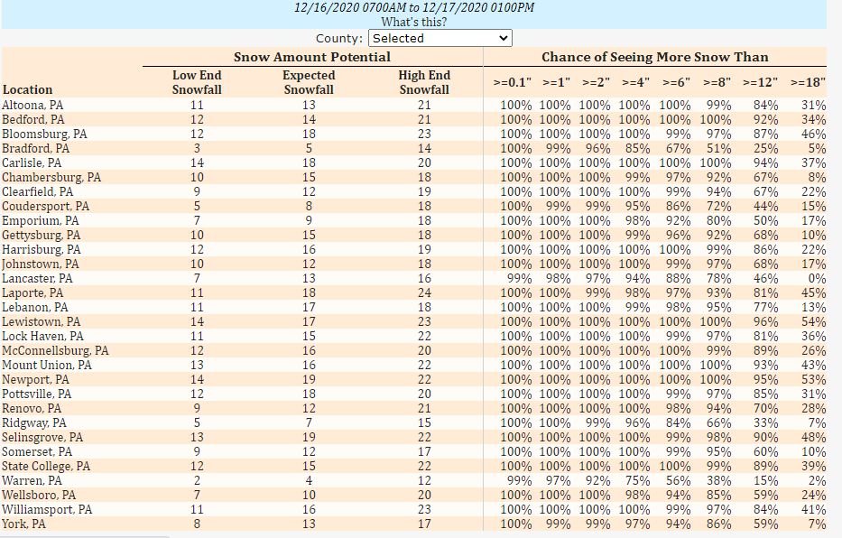
NWS low/probable/high with percentages for central pa
-
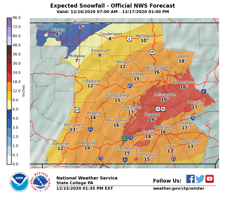
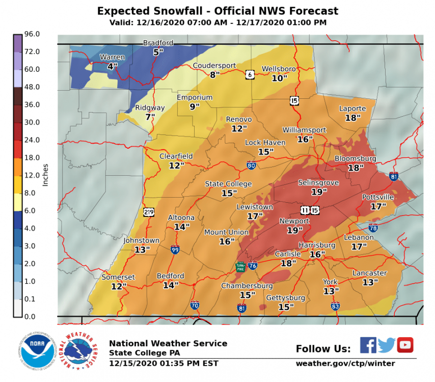
NWS expected snowfall map afternoon update
-
Just got bumped to a Winter Storm Warning in Tioga County Tioga- Including the cities of Mansfield and Wellsboro 1200 PM EST Tue Dec 15 2020 ...WINTER STORM WARNING IN EFFECT FROM NOON WEDNESDAY TO 10 AM EST THURSDAY... * WHAT...Heavy snow expected. Total snow accumulations of 8 to 13 inches. * WHERE...Tioga County. * WHEN...From noon Wednesday to 10 AM EST Thursday. * IMPACTS...Heavy snow may make for very difficult to impossible travel conditions, particularly for the Wednesday evening commute through Wednesday night. * ADDITIONAL DETAILS...Snowfall rates of up to 2 inches per hour are expected late Wednesday and Wednesday night.
-
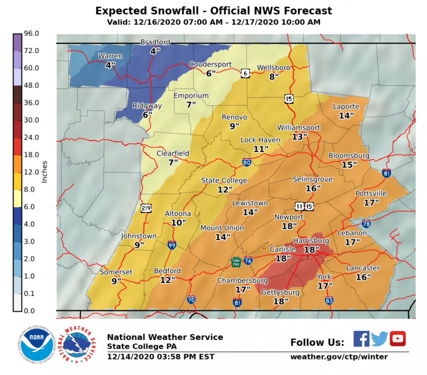
nws first call expected totals....
-
Snowing nicely in tioga near wellsboro. About 3 inches so far
-
checking in near wellsboro,pa. right around 10 inches and still coming down nicely. radar still looking pretty good for a couple more hours of snow.