

AshVegas
-
Posts
28 -
Joined
-
Last visited
Content Type
Profiles
Blogs
Forums
American Weather
Media Demo
Store
Gallery
Posts posted by AshVegas
-
-
19 minutes ago, Met1985 said:
What's everyone's temp currently? Im sitting at 48 degrees.
55 in North Asheville
-
 1
1
-
-
1 minute ago, BornAgain13 said:
Hi Res Nam not near as good but still not bad!
Still snowing
-
Steady light snow in North Asheville this evening. Congrats to all those that cashed in!! See if we can do it again next weekend!
-
1
-
-
7 minutes ago, Hvward said:
Still 24hrs+ of snowfall possible around WNC with this current event, this flow will mean business.We sure need it in North Asheville after the rain put a damper on the snow mid afternoon. Typically we set up well in flow snow as you mentioned in the video.
-
4 minutes ago, LiQuiDBuD said:
My point forecast says high of 27 today, I've hit 32.4 about an hour ago and now dropping to 31.5. Busting big time on the high side temp wise.
Sent from my Pixel 6 Pro using Tapatalk
Sky rocketed to 37 in North Asheville after a projected high of 31.
-
Up to 33 degrees and raining in Woodfin after getting 5" of snow this morning.
-
 1
1
-
-
Snow starting to mix with sleet in N. Asheville.
-
Couple flakes flying in North Asheville. Beaverlake/Reynolds Mountain area.
-
2
-
-
2 minutes ago, WeatherHawk said:
Same issue for Wataga county, I was told that some members of the DOT were out sick
Same with McDowell County. Only going to focus on 221, i40 and road to the hospital. Really messes with the manufacturing plants as they usually have priority after the main roads.
-
3 minutes ago, buckeyefan1 said:
hrrr at 18

FBRV snow going to the crapper real fast.
-
Just now, BretWx said:
LOL

Oh....ok. LOL.
-
6 minutes ago, snowmaker13 said:
0z national blend of models now has under 6 inches of Snow for asheville. Should have managed my expectations better. Expecting 3-6 inches with 1.5 of sleet/freezing rain.
Data, please?
-
Always love the FBV snowhole. We've all seen this progressively get worse as winter storms get closer. However, can't complain too much about 6"+.
-
2
-
-
22 minutes ago, BretWx said:
Don't start jumping now. It's the NAM at 60hrs. And it's still snowing.

From my experience, the snow hole is true but typically only a couple inches less than the surrounding areas. Nothing this extreme.
-
1
-
-
1 minute ago, snowmaker13 said:
You know it's true because its got the Asheville snow hole. Never fails. Anything is better than nothing though!
You know it's real when that shows up!!
-
3 minutes ago, NavarreDon said:
What’s the timeline, when does a decision have to be finalized? If you have time follow the model trends. Depends on what part of Hickory & what part of Black Mountain. I’d wait as long as possible to gather the most info then make the call. The great thing is either way will be a win!
.I think it ultimately depends on where the location is in Black Mountain. Often we get caught in the French Broad valley death trap in some of these storms. You can see it depicted on some of the snow maps - closer to the McDowell/Buncombe line the better.
-
 1
1
-
-
HAPPY HOUR BOOM!
-
1
-
-
5 hours ago, jburns said:
That’s my storm. I posted a few pictures yesterday. My house is right under the 20.
I lived in south Monroe at the time and we had 18" and no power for almost 2 weeks. There was a smaller storm that Saturday, rain Sunday and then BOOM!
-
8 minutes ago, wncsnow said:
Same here. don't think we will get 2 to 3 at this rate
Lots of models didn't show accumulations until 00z...
-
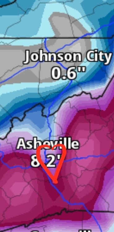
HRRR finally caught up to the other models...time will tell with the radar returns. Notorious French Broad snow hole is always a potential.
Light snow @36/27
-
6.5" of solid cement in Woodfin.
-
Heavy sleet just north of downtown Asheville. Killing our snow totals.
-
Transformers blowing in Asheville...
-
Heavy snow in Asheville with a few inches down. Power already out 2x...hoping for the best!

2023-2024 Fall/Winter Mountain Thread
in Southeastern States
Posted
Sent from my SM-S906U using Tapatalk