
dailylurker
-
Posts
3,833 -
Joined
-
Last visited
Content Type
Profiles
Blogs
Forums
American Weather
Media Demo
Store
Gallery
Posts posted by dailylurker
-
-
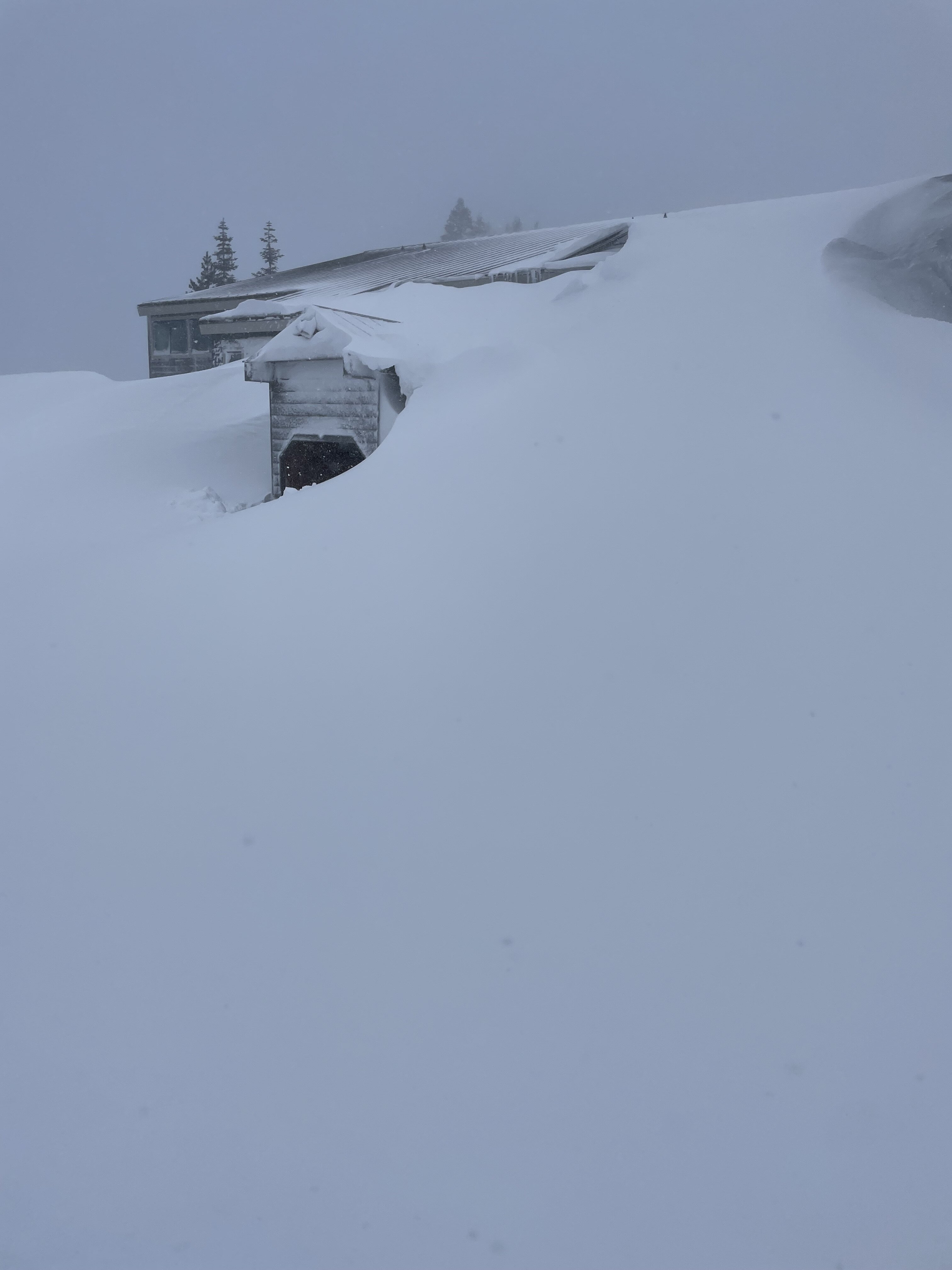
3 hours ago, katabatic said:
This sure has been one hell of an adventure. I don’t have power, I don’t have Internet although my phone still works thankfully. The snowblower that the condo uses to dig us out is broken and they don’t think we’re gonna get any back up until at least Monday. I estimate we’ve had about 7 feet with another 4 to 6 to come. If I don’t get out on Monday which is when my flight is, Tuesday and Wednesday we’re going to get another 2 feet.
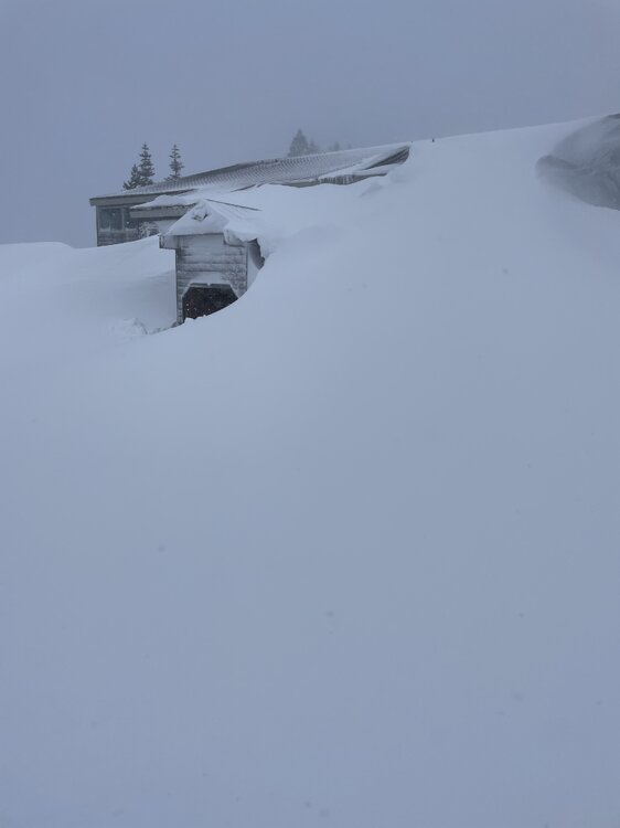
This is amazing. I've been watching Webcams up there. It looks pretty crazy today. Do you have a shovel? I'd be digging that entrance out for fun.
-
 1
1
-
-
It's another tropical flooding rainstorm. One thing we do great in our new climo is tropical rain. It's killing off our oak trees at an alarming rate. Our forest are going to be full of invasive plants and trash trees. Forget the lack of snow. This shit is killing our forest.
Heavy tropical rain and probably 50 degrees.
-
2
-
 2
2
-
 1
1
-
-
13 hours ago, George BM said:
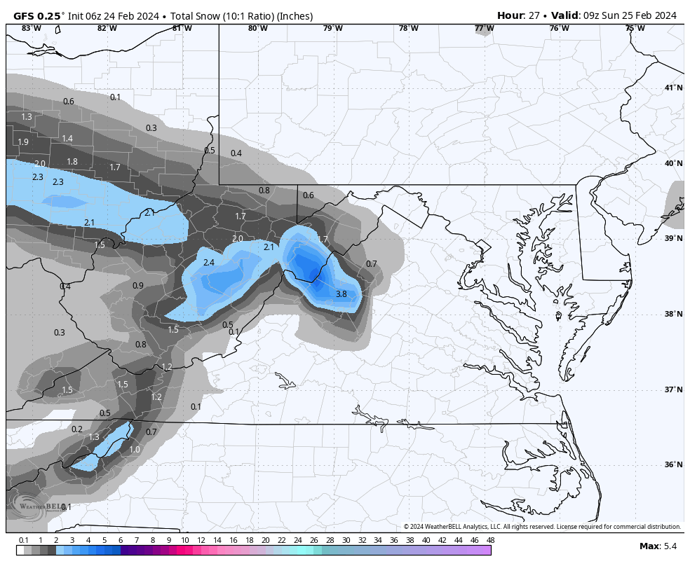
Forecast Discussion
Saturday, March 16, 2024 3:28PM EDT
Blizzard Warning in effect from 8AM EDT Sunday, March 17, 2024 until 3PM EDT Monday, March 18, 2024
High Wind Warning in effect from 9AM EDT Sunday, March 17, 2024 until 6PM EDT Monday, March 18, 2024
Hurricane-Force Wind Warning in effect from 2PM EDT Sunday, March 17, 2024 until 6AM EDT Monday, March 18, 2024 (for tidal-Potomac and Chesapeake Bay)
Life-Threatening Late-Winter Storm to cripple the region.
Temps are currently holding in the mid-50sF across the DC metro area but are already starting to fall in far northern Maryland as the cold front associated with the strong northern stream system drops south through the region. Temps will plummet out of the 50s and through the 40s and 30s through the evening and reach the lower 20s in many areas by morning as the unusually cold airmass pushes in. As this occurs through the late afternoon and evening hours skies will become overcast both from lift associated with the southward moving cold front and from the strong southern stream system to our south/southwest. There may be enough lift and moisture associated with the front for some light sprinkles and/or a few flurries/light snow showers to develop through the evening before precip slips to the southeast. Northerly winds will become quite gusty during this time with gusts of 25 to 40 mph.
As the strong southern storm system moves toward the coastal Carolinas tonight it will begin to phase with a second powerful northern stream vort diving south from the eastern Great Lakes/ Toronto region leading to strong diffluence over the surface low leading to rapid deepening. The two will pinwheel around each other as they phase bringing the southern storm and associated surface low northwards as rapid deepening takes place allowing snow to overspread the region by morning from southeast to northwest. The snow will quickly become heavy as NE winds increase with gusts to over 50 mph across the region likely by midday. Temperatures during this time will be in the lower 20sF leading to windchills in the single digits. By the late afternoon/evening the surface low will slow down and eventually stall over the Virginia peninsula/ southern Chesapeake Bay area. The surface pressure could be as low as the mid-950s in millibars breaking monthly low-pressure records in that area. Meanwhile, the areas northwest of the surface low (the greater Washington DC and Baltimore metros) will be getting the worst of this storm with blinding snowfall and widespread 60-75+ mph wind gusts w/ 80-90+ mph gusts along the coast of the Bay. In fact, snowfall rates in the heaviest bands will likely be in the 4-6”+/hr range leading to visibilities as low as 50 feet (effectively zero visibility for the sake of argument) from the late afternoon hours through the night and into Monday morning. Temperatures will remain in the 20s throughout the duration of this event with upper teens possible in the higher elevations north and west and temperatures closer to 32F in far southern MD and along the bay where warmer air will be located near the surface low. Windchills during the duration of the event will stay in the single-digits for most w/ negative single-digits in the mountains and lower teens in southern MD and along the bay.
Near-whiteout and conditions and severe wind gusts will still be ongoing by dawn Monday as the low-pressure system slowly pulls northeastwards. Heavy snow will continue through the late morning to midday hours before tapering off from west to east. When all is set and done with total liquid-equivalent precipitation of 4-7”+ across the region, snowfall totals of 4 to 6 FEET will likely be commonplace with snow drifts of as high as 30 feet possible. Areas in southern MD and near the Bay may end up with slightly less (roughly 2 to 4 feet) as the warmer air associated with the low-pressure center cuts down on totals in that area.
This will be the worst blizzard, by far, to impact the region since weather records started in the later 1800s. It will essentially be a high-impact hurricane with snow instead of rain as the main precip-type. People who venture outside during this time may get disoriented and lost in the whiteout conditions and/or get seriously injured by flying debris. Emergency services may not be able to reach you for days should something happen to you outside. This is the DC and Baltimore urban corridor not Lake Tahoe or the Japanese Alps. We’re not equipped with the snow removal equipment that they have. So, if you absolutely must venture outside during the storm no caution that you use would be too extreme given the circumstances.
Temperatures will only rebound to the lower 30s as skies start clearing by mid to late afternoon on Monday.
Forecaster Wannabe: George BM
Can we take the part out about lower totals near the bay? How about CAPE gets screwed and gets 6" of rain while AA county is in the extreme snowfall rates due to R/S line of Kent Island. Lollies to 6' along the PG/AA county line. Can I also get some thunder in there?
-
2
-
-
23 minutes ago, nj2va said:
Yay for first day of spring! Bring on the 60s and sun.
Yay! 8 month of fall continues lol.
Low 28
-
50 minutes ago, psuhoffman said:
I think its made worse by perception bias...because winter is so much warmer than "normal" lately...I think there is just this expectation it will get warmer as we head into early spring...but it doesn't necessarily work that way since the water which is a big part of why its so warm in winter is cooling by then due to the lag effect in water temps. So often when we get a very warm Feb-mid March...late March and early April might not really end up much warmer and that "feels wrong".
So basically we have fall for 7 months now. I'm glad I got one week of winter lol
-
35 minutes ago, WxUSAF said:
She told me she’s out as of an incident in late January
That's a shame. She was a regular the entire time I've been here. Let's try to be nicer to each other. There's lots of weird and interesting people here. Let's just let people be weird. I saw a dude dressed like a fox in Walmart last week. I just barked like a dog at him. I suddenly identified as a dog. Shit was fun. I'm not gonna lie lol
-
 3
3
-
-
Anyone seen Mappy lately? I feel like she hasn't been on the board all winter.
-
It's almost potato planting time! Saint Patrick's Day weekend is prime time SE of the fall-line. When I lived NW of the fall-line I planted 2 weeks after SPD weekend. Potatoes do great here in MD. Fresh potatoes are delicious!
-
My greenhouse doors are wide open and my flowering cannabis plants love it. These plants will be done in 4 weeks, then it will be time to start tons of veggies for the upcoming season.
69 wtf
-
2
-
-
5 minutes ago, stormy said:
Weak low pressure over southern Ohio will move southeast across west/central Va. this afternoon and evening. NAM/GFS/ECM and GEM all give accumulating snow across portions of Augusta late afternoon and evening. Surface temps. below 2000 ft. will be marginal though column temps. look fine. Accumulation expectations range from 2 - 6 inches. This will be an elevation event for accumulations. 2000- 4000' 2 - 6 inches, 1000 - 2000 ft. a dusting - 1 inch.

If I were to drive out there this afternoon. Where would you go to see this happen? I was kinda thinking about hiking today. I'm near Annopoils but can drive out there.
-
10 hours ago, Ji said:
If you had a good winter than I had a good winter because 90% of my winter enjoyment is tracking and digital. The actual event is so short and stressful that it’s not that enjoyable unless we are performing or over performing. And post storm is super depressing. I’m wired a bit different I guessYou're definitely weird but that's ok. My first thought is to give you some wisdom filled response about living in the moment and being grateful for the positive things in your life. Then I thought about how you probably have heard that kinda stuff your entire life. We all find joy in our own little weird way. Just because you don't think like I do, doesn't mean I need to help you think differently. A lot of people think im weird for wondering around smoking joints in the woods all day while its snowing. I hope you get lots of digital blue and exciting PBP's in your future. Stay weird, my friend.
-
1
-
-
34 minutes ago, MountainGeek said:
I suppose it is better than drugs and giant tomato worms.....
Cannabis isn't a drug lol
-
1
-
-
3 hours ago, stormtracker said:
This winter has made me bitter. Time to bring back tear Beethoven avatar.
I forgot about that lol.
-
March and the first 2 weeks of April are hands down the shittiest 6 weeks in this area. Super boring weather.
-
16 minutes ago, mattie g said:
Sounds interesting. That said, my process is really solid, and I can't imagine harvesting more than I already get! My plants get up to 15' long (maybe even more lol) and I generally harvest from early-July until late October. Might be an interesting thing to do as an experiment, though.
Feed more micronutrients and less nitrogen. Tomatoes love magnesium and calcium. They grow less tall and produce better Tomatoes. My plants usually don't get taller then 6' but produce about 75 pounds of Tomatoes. I grow heirloom verities. Try starting seeds the last week of March and plant them once it's 60 or above at night. You'll have bigger, better quality Tomatoes. The plants will catch up to the early ones and then pass them. I've been growing Tomatoes for 35 years. I've tried just about everything.
-
2
-
 1
1
-
-
18 minutes ago, mattie g said:
It's not too early. I know because I follow the same process every year and I have everything I need to keep plants healthy and strong before planting.
I'll up-pot two times before hardening off and getting the plants in the ground sometime between mid-April and early-May. I plan my planting schedule based on the long-range forecast, and if I feel that I can get them in the ground without fear of getting zapped by cold then I'll do it. A few years ago, we had that early-May cold spell, but I covered up the plants and they withstood it without any issues.
Try planting when it's hot in mid May. Try one or 2 plants this year. They'll outgrow the plants you put in a month earlier and will double the harvest. Guaranteed. I grow 400-500 pounds of heirloom tomatoes each season.
-
1
-
-
40 minutes ago, mattie g said:
Got my first seeds planted and under lights yesterday. I've been getting my seeds from Territorial Seed Company for quite a few years now, so I'm a little nervous about picking up the seeds from the nearby nursery this year. Hopefully the germinate and all is well!
-
Tomatoes
- San Marzano
- Amish Paste
- Coeur de Bue
- Jersey Devil
- Roma
- Sugar Cherry
- Jalapenos
- Broccoli
- Lettuce
- Basil
- Parsley
I'll probably be starting some others in a few weeks and will be direct sowing mache, spinach, and more lettuce by the middle of March. Dill will go in later.
It's on!
Too early. They'll be root bound by the time you plant. I start my tomato seeds 6 weeks before planting in mid May. The herbs will need bigger pots in a few weeks. Lots of light. You need real deal, full spectrum LED lights to sustain summer plants during this time of year. I have a greenhouse and grow cannabis during the winter.
-
Tomatoes
-
Hopefully next year will be a disaster, worst pattern ever, la Nina, blah blah blah.. than we'll most likely have a great winter. It's always the opposite of what humans expect. Soon as I hear we're in for a great winter I begin to worry lol
-
Since winter is dead, we might as well move on. I was day dreaming the other day about spring evenings with rumbling thunder, fireflies and outdoor cannabis plants. I'm a fan of general thunderstorms. I love a good late night summer thunderstorm, especially when down at the beach.
-
4 hours ago, southmdwatcher said:
January 25, 2000, is the greatest surprise snow event in the last 40 years. My memory is that we and the whole Northeast had a busted major storm/blizzard. After the busted blizzard, the weather was fine, but there was an outbreak of thunderstorms across the Southeast on the 24th. The weather forecast was still not indicating snow for the Mid Atlantic. However, THE sign was friends of mine from Charlotte NC, calling me early that afternoon on January 25, 2000, saying they were supposed to be 50 degrees with a few showers, and it was snowing heavily, with major accumulation. Radar continued to show the snow moving more northward than northeast. Our forecast was for a few flurries in DC and maybe minor accumulations up to an inch east of DC. Well, early evening the TV's all belted out the Winter Storm Warning's with accumulations of 8 to 12 inches and we still beat that. Still as amazing and surprising as that event was, PD1 on February 19, 1979, absolutely slammed that overnight.
Remember it like yesterday. I was expecting anything. I was out drinking under age at a buddies house. Drive home (I know, not good). When I got out of my car at midnight and looked up. The moon was gone and the wind had picked up in a weird way. I went inside and looked at the local on the 8's. The radar came on and I almost fell over. Their was a monster wall of snow right on my doorstep and racing nw. It went from a few flakes to an inch per hour within 15 minutes of starting. It was wild. I was only 3 months old for the blizzard of 79. My mom said I stared out the window for two days straight. I was born loving nature and all things weather related.
-
4
-
-
Is this the one where it was almost 70 degrees the next day? Typical lol. Jan 25, 2000 was my 1979 storm. It happened during the day.
-
1
-
-
3 minutes ago, snowfan said:
All it takes is 1 storm. January 96 and January 00 were both in Nina’s. Outliers, yes, but it can happen.
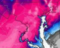
Jan 25, 2000 was epic here east of DC. Extreme snowfall rates 4-5" per hour at my house. Probably even 6" rates during the peak. I got 21" that day. Forecast was for 3-5. It was Forecast to miss us, the day prior. Sorry for banter lol
-
3
-
-
I'm recording this as 1 inch for my total. That brings me up to 12" for the season. Most of that 12" was high quality, long lasting, cold smoke from Jan, so I can't complain. Most likely this is my season total. Better then the past 10 years lol
-
3
-
-
1 minute ago, psuhoffman said:
It’s really hard to get snow in Savannah no I mean Washington DC.
I'm just east of DC. I still can't believe we had a week of winter here. That's super rare these days.
March Discobs 2024
in Mid Atlantic
Posted
Swampy down here in the lowlands. Another tropical rainstorm here. I haven't looked, but probably an inch overnight. I have the opposite problem here than you have.