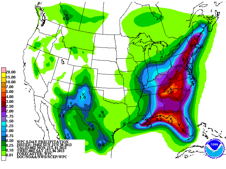
A very interesting pattern for the next 72 hours or longer for the Southeast US...
Our first wave of rain has departed the region and is hitting the Mid-Atlantic and up into New York. Item #2 is the mass of precip that's forming in the Eastern Gulf of Mexico...the global models didn't see this one coming. One has to believe it has Eastern Georgia and the Carolina Piedmont as its destination tonight. Along with that enhancement, most of the Southeast (East of the Apps) shall destabilize enough to allow scattered convection to develop.

That now brings me to item #3...there is IMO a growing concern for flash flooding and flooding for the Southern Appalachian Region down to the Gulf Coast starting Wednesday. As tonight's feature exits, the big 500mb trough should begin to slowly retrograde allowing the Bermuda High to also shift westward.
That will result in more of a Southeast wind orientation for areas of North Georgia and the Western Carolinas which will help to enhance precipitation. Infact the 12z NAM shows an interesting LLJ potential for 0z Wednesday (Tuesday Evening/Night) with 35 kt flow at 850 and 925 mb...that to me is an alarm for nocturnal convection along the eastern slopes of the Apps in Western North Carolina...

Also in play is a bundle of energy at 500mb that is currently situated over the Northwest Caribbean. By 48 hours, those vorts will be surging north from the Gulf of Mexico with its eyes set from the Florida Panhandle northward to the Southern Appalachians. Folks, not often do you see weather of a Caribbean origin affect our part of the country

@54...

@ 60...

Central and Eastern Carolinas have racked up so far but the worst in general is yet to come...am very concerned about Wednesday right now.


Recommended Comments
Create an account or sign in to comment
You need to be a member in order to leave a comment
Create an account
Sign up for a new account in our community. It's easy!
Register a new accountSign in
Already have an account? Sign in here.
Sign In Now