All Activity
- Past hour
-
Bit more dreary yesterday than I was expecting, showers kept it cool for a lot of the day. Managed to get to 69 before the rain but temps dropped all the way to 59 before rebounding to 68 late in the day again. Just 0.06” but every drop here is needed
-
Down to 28 last cold of the season?
- Today
-
The soil moisture data at the Waldorf mesonet site perfectly illustrates this point.
-

Severe Weather 4-25 through 4-28-24
Powerball replied to cheese007's topic in Central/Western States
Fleeting was probably a better word. In addition to the increased cloud cover limiting insolation needed for sufficient surface-based instability, there's also some correlation during an El Nino with the weaker surface wind fields limiting the extent to which warm/moist air from the Gulf advects northward (unlike during a La Nina). I wouldn't expect models, especially those that aren't convection-allowing, to pick up on these details several days out. The ENSO state is only one of many factors, but possibly one that shouldn't be ignored/dismissed as a significant factor for the underwhelming season thus far. https://www.climate.gov/news-features/featured-images/el-niño-and-la-niña-affect-spring-tornadoes-and-hailstorms -
Parakeets in southern Connecticut thriving in January and barely hanging on in late April
-
Ready for some Iowa/Missouri sloppy seconds Fri-Sun. Nice rains on the way.
-

E PA/NJ/DE Spring 2024 OBS/Discussion
Birds~69 replied to Hurricane Agnes's topic in Philadelphia Region
NBC10 and Fox29 had Philly 62-63F range for Sat. So yeah, we may stay in the 50s; 50F @ a little past midnight...
-
Down to 34° here. Maybe hit upper 20s by sunrise? I’m not too worried about the local orchards etc. This is pretty normal April cold.
-
You would need a Day After Tomorrow scenario to kill off ticks.
-

April 2024 Disco- SNE’s favorite month
DavisStraight replied to HoarfrostHubb's topic in New England
How about 10 below and kill some ticks. -
1. It was warmer today here but still very pleasant with dewpoints as low as the upper 40s early this evening. The walking was so enjoyable. 2. 114 years tomorrow Atlanta amazingly enough had 1.5” of snow!! This is to me easily its most freak winter storm on record. It is 3 weeks later than the second latest accumulating snow there on record, three weeks later than Greensboro’s, one week later than Raleigh’s/GSP’s, and 5 days later than Charlotte’s latest measurables! More details are here:
-
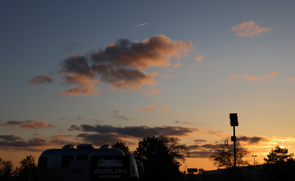
After a day of being around a frontal boundary and all the clouds that entails, Around sunset, the clouds took a hike rapidly. Taken with the 24-70mm at 61mm...

-
Watching playoff hockey on a CAA evening feels fitting. It doesn't mean anything in the larger context of things, but it was more of a cold season vibe than warm season. With playoff hockey.
-
Wood smoke in the air and a Marchand beat down of the Leafs. Doesn't get much better...
-
GWDLT
-

April 2024 Disco- SNE’s favorite month
RUNNAWAYICEBERG replied to HoarfrostHubb's topic in New England
Those window units are humming man…down to 59.6 ey. -
University of Pennsylvania predicts 33 named storms this year. That's quite bold Sent from my SM-G970U using Tapatalk
-

Severe Weather 4-25 through 4-28-24
CheeselandSkies replied to cheese007's topic in Central/Western States
I think a little of both. However, to my point below; each potential threat recently has had some obvious limiting factors apparent in the model data within a few days out (moisture depth, wave timing, etc). I was under the impression that we were actually currently moving out of El Nino toward neutral and then La Nina (hence also the universally very high-end forecasts for the Atlantic hurricane season)? *** The models showing a big, amplified trough with moisture is one thing; however, details matter. Most of the prior setups this year have had significant caveats become apparent within the 3-5 day range. However the amateur social media hypelords either didn't know or didn't care to point them out. @andyhb is right, this one is not downtrending to any degree that I'm seeing. If anything; each subsequent model run is only reinforcing the idea that the ceiling is quite high and something significant could happen each day starting tomorrow through Sunday. Now, will it? Not necessarily, but confidence it's higher than it's been in quite some time IMO. -
Definitely a deep cold looking at the mountain temps. What's interesting is the exposed upper mountain temperatures continue to cool off faster (relatively, the delta is larger up high) than the lower elevations on the east side. Two sites, over a mile apart at 3,600ft are showing 16F. While two sites, at mid-slope are 7F warmer at 1K lower elevation. That's a steep lapse rate that is common with continued CAA from the NW up there. Low levels are harder to drop, but up high in the free air is cooling much faster. Cold air aloft. Looking at the mountain profile... 3,600ft... 16F 2,600ft... 23F 1,500ft... 27F 750ft... 30F
-
went outside to play with the dog for a bit after the 1st. It was definitely a winter feel with the wind.
-
30F at MVL and 29.7F at nearest PWS. It is cold outside. There's still some NW wind too. Not fake.
-

Central Pa. Spring 2024
Blizzard of 93 replied to mahantango#1's topic in Upstate New York/Pennsylvania
It’s still snowing near Yellowstone. -
Central Pa. Spring 2024
Blizzard of 93 replied to mahantango#1's topic in Upstate New York/Pennsylvania
Winter Storm Watch URGENT - WINTER WEATHER MESSAGE National Weather Service Great Falls MT 145 PM MDT Wed Apr 24 2024 MTZ327-329-330-251045- /O.NEW.KTFX.WS.A.0011.240426T1200Z-240428T1200Z/ Northwest Beaverhead County-Ruby Mountains and Southern Beaverhead Mountains-Gallatin and Madison County Mountains and Centennial Mountains- Including the following locations: Wise River, Raynolds Pass, Big Hole Pass, West Yellowstone, Wisdom, Dewey, Big Sky, Targhee Pass, Monida Pass, and Chief Joseph Pass 145 PM MDT Wed Apr 24 2024 ...WINTER STORM WATCH IN EFFECT FROM FRIDAY MORNING THROUGH LATE SATURDAY NIGHT ABOVE 7000 FEET... * WHAT...Heavy snow possible above 7000 feet. Total snow accumulations up to 3 inches below 7000 feet, with over 12 inches possible above 7000 feet. * WHERE...The Mountains of Southwestern Montana south of Interstate 90. * WHEN...From Friday morning through late Saturday night. * IMPACTS...Travel could be very difficult to impossible and tire chains may be required for some vehicles. Those in the backcountry should ensure they have appropriate knowledge and gear and may want to consider alternate plans. -
I hope we hit teens
-
birds are crying for their mommas down here. I hear desperate cries out loud. What type of sociopath would want such a thing?


.thumb.png.a39dd6246063eee0ff2057401bdf7402.png)