All Activity
- Past hour
-

2025-2026 ENSO
Stormchaserchuck1 replied to 40/70 Benchmark's topic in Weather Forecasting and Discussion
I'm liking the cold tendency (-AO tendency) this cold season. Something like 97-98 and 01-02 are the farthest thing from right now. Notice how the modeled 500mb maps have more cold than warm anomalies in the N. Hemisphere.. we haven't seen that in like 10 years. When I researched snowfall in Winter the N. Hemisphere negative 500mb (general) was the strongest thing preceding. I'm trepidacious about an above average snowfall Winter down here, but we do have a better pattern coming compared to the last 10 years imo. Anyway, good job on your analog outlook. -
Or wait another month. The average high at BWI on Dec 2nd is 47 degrees
-
21.4" on the month at WXW2. Absolutely nuts to pass my entire season snowfall in CT last year in less than a month up there--in November. It just piles up, pennies and nickels.
-

2025-2026 ENSO
40/70 Benchmark replied to 40/70 Benchmark's topic in Weather Forecasting and Discussion
I think so...which is why I wanted you to bet. I was very confident in a fast start to the month based on my analogs. -
Nov 28-30th Post Turkey Day Winter Storm
ChiTownSnow replied to Chicago Storm's topic in Lakes/Ohio Valley
Confirmed. Midsize flakes but starting to stack -

First Winter Storm to kickoff 2025-26 Winter season
ineedsnow replied to Baroclinic Zone's topic in New England
UKIE kind of meh but high end advisory snows -

2025-2026 ENSO
Stormchaserchuck1 replied to 40/70 Benchmark's topic in Weather Forecasting and Discussion
The +EPO and cold probably isn't going to happen like that.. it's going to be one or another. If the negative 500mb over Alaska holds in the next few days, models will probably trend warmer in the CONUS. CPC yesterday put out a cold 3-4 week forecast though, with above average precip -
Looking at cloud mass movement it look like 9 hours until rapidly increasing clouds commence so 8-9 pm
-
GFS is days and days starting next weekend
-

2025-2026 ENSO
Stormchaserchuck1 replied to 40/70 Benchmark's topic in Weather Forecasting and Discussion
You going to get 3"? Glad I didn't bet you. The strong -PNA/+NAO being modeled didn't really happen. -

First Winter Storm to kickoff 2025-26 Winter season
Damage In Tolland replied to Baroclinic Zone's topic in New England
I can’t believe it ! -

Nov 28-30th Post Turkey Day Winter Storm
michaelmantis replied to Chicago Storm's topic in Lakes/Ohio Valley
2 inches on the ground as of 10 AM. Flake quality in last hour improved a ton. No huge flakes yet, but this new stuff is stacking nicely. -

First Winter Storm to kickoff 2025-26 Winter season
ineedsnow replied to Baroclinic Zone's topic in New England
I'm starting to like my spot for this... then a nice follow up storm on the GFS.. CMC also trying -

E PA/NJ/DE Autumn 2025 Obs/Discussion
Birds~69 replied to PhiEaglesfan712's topic in Philadelphia Region
Blizzard cancel? -

First Winter Storm to kickoff 2025-26 Winter season
40/70 Benchmark replied to Baroclinic Zone's topic in New England
Sell early phase. -
That's what I just saw as well. Research prior to the birth of many younger mets. I still think it worthwhile for forecasters who have time, to run a quick check.
-
cutlew started following Nov 28-30th Post Turkey Day Winter Storm
-

Nov 28-30th Post Turkey Day Winter Storm
sbnwx85 replied to Chicago Storm's topic in Lakes/Ohio Valley
HRRR picking up on a heavy lake effect band/mesolow swinging through Berrien County mid-late Sunday afternoon. Would be a mess with 10-12” already on the ground. -

Nov 28-30th Post Turkey Day Winter Storm
tuanis replied to Chicago Storm's topic in Lakes/Ohio Valley
Still pretty light rates here, closing in on an inch. Hope this afternoon cranks, probably another 10 hours or so of accumulating snow to go. -
I guess it’s just a spot without any pavement and a lot of farmland. Just happens to have a weather station there. Mine is actually on top of a hill so I’m sure there are colder spots on the farm too. Last year with snow cover it was exceptionally cold compared to RDU
-
Nov 28-30th Post Turkey Day Winter Storm
mimillman replied to Chicago Storm's topic in Lakes/Ohio Valley
Pretty big bust incoming for you -
Time now for snowier solutions cycle to reappear
-
First Winter Storm to kickoff 2025-26 Winter season
dryslot replied to Baroclinic Zone's topic in New England
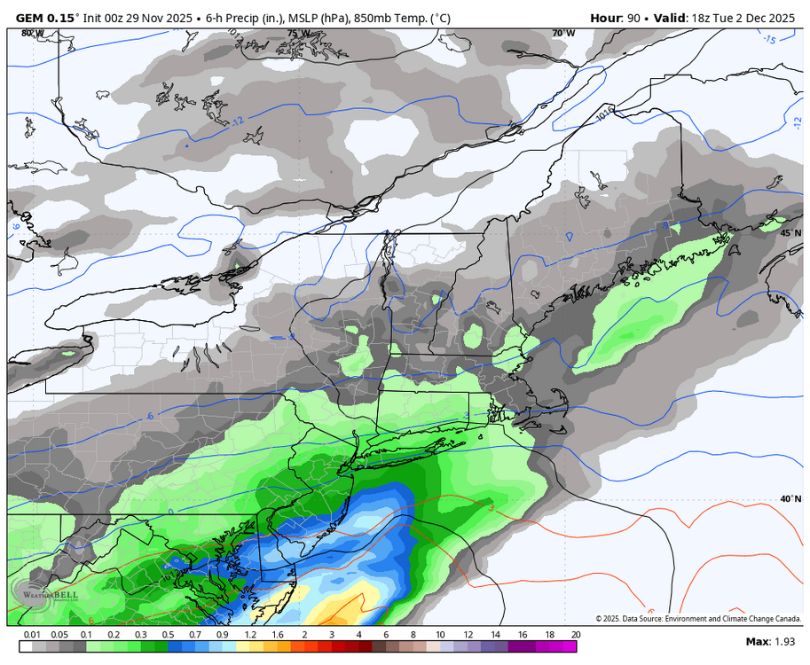
Huge actually lol, It has a bit of a hybrid look to it, Almost a bit SWFE ish on some of these runs, The 12z Euro should be of interest to see what it does. -

First Winter Storm to kickoff 2025-26 Winter season
powderfreak replied to Baroclinic Zone's topic in New England
-
Nov 28-30th Post Turkey Day Winter Storm
A-L-E-K replied to Chicago Storm's topic in Lakes/Ohio Valley
Quality at the moment -

2025-2026 ENSO
40/70 Benchmark replied to 40/70 Benchmark's topic in Weather Forecasting and Discussion
I probably rushed the PV recovery, which I can live with...the bigger deal is getting the Pacific trough transition correct.


.thumb.png.6b6421c8887eedf4d3f2d366e6ff89de.png)
