All Activity
- Past hour
-

First Winter Storm to kickoff 2025-26 Winter season
moneypitmike replied to Baroclinic Zone's topic in New England
12z HRRR and RAP. These are essentially the last maps that will capture the entire storm (subsequent ones will miss any earlier accums). -
I believe in the 0z Euro

-

December 2025 regional war/obs/disco thread
SouthCoastMA replied to Torch Tiger's topic in New England
The ensembles have a pretty strong signal on Day 9/10. Whether that pans out positively for SNE is the WinterWolf question of the day. We just don't know. -
trees are glazed a bit here in western loudoun 31.8
-

December 2025 regional war/obs/disco thread
WinterWolf replied to Torch Tiger's topic in New England
The reset (if real) is two weeks away. Lots will change between now and then. -
Flipping between snow/ice depending on the intensity. Our school district closed; but Murphy calling a state of emergency for northwest Jersey may be more ridiculous.
-
Some sleet mixing back in with the rain now. Still 32°. Edit- just like that, it’s back to snow.
-
December 2025 regional war/obs/disco thread
WinterWolf replied to Torch Tiger's topic in New England
He’d be giddy inside. -
 fwiw... heading for nw NJ... a widespread area of mdt-heavy snow over ne pa and heading ne. vsby aob 1/2 mi there.
 -
December 2025 regional war/obs/disco thread
WinterWolf replied to Torch Tiger's topic in New England
Thank you. -
 Expecting a fairly quick transition here as well. Areas to my south in SE PA have already gone to sleet/rain.
 -
December 2025 regional war/obs/disco thread
WinterWolf replied to Torch Tiger's topic in New England
This is Shocking Brett. -
Maybe @wxmeddler can pull a profiler site up? He's famous for finding those nuggets of information.
-

December 2025 regional war/obs/disco thread
Kitz Craver replied to Torch Tiger's topic in New England
Whoa, whoa, whoa, so you are saying we just don’t know? -
Yep, nice to just get the moisture in here!
-
(002).thumb.png.6e3d9d46bca5fe41aab7a74871dd8af8.png)
Central PA Fall Discussions and Obs
ChescoWx replied to ChescoWx's topic in Upstate New York/Pennsylvania
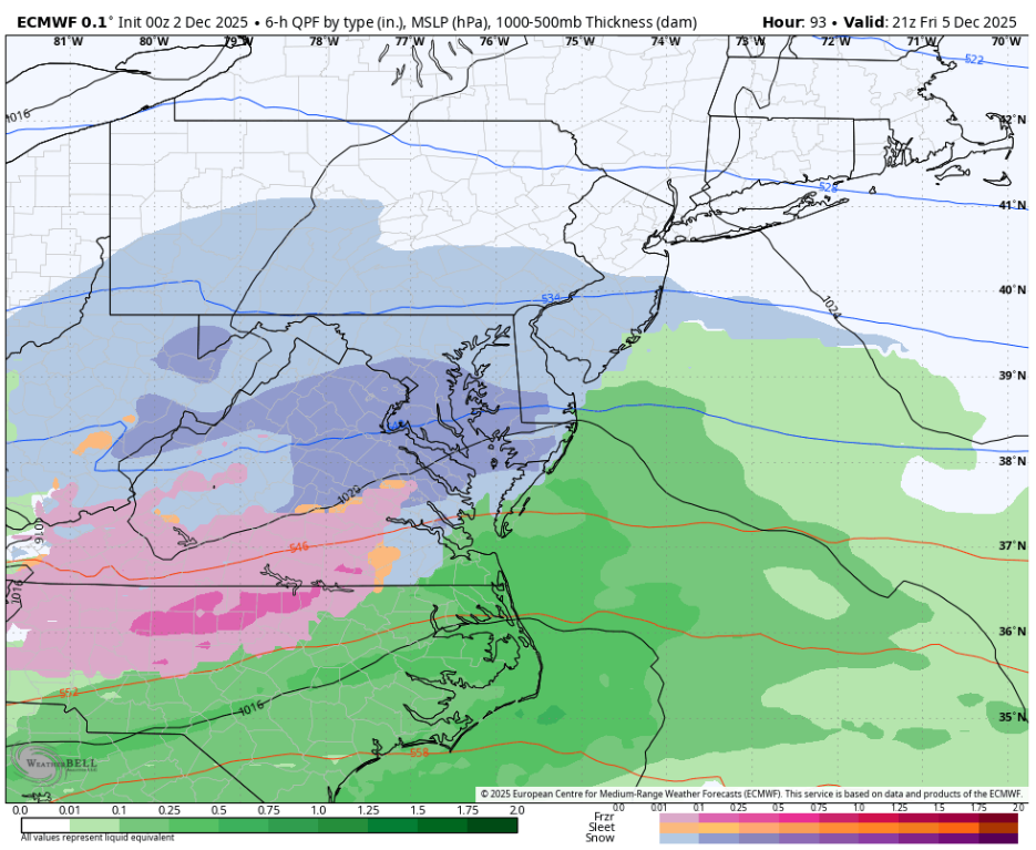
This morning's wintry mix our 2nd winter event of the season should slowly change to plain rain as we rise above freezing in most spots by later this morning. Some higher ridge spots may take into the early PM to get above freezing. Be careful if out driving this morning. Either way the rain will end later today, and we will stay much colder than normal for the rest of the week. Our warmest day looks to be tomorrow with temperatures near 10 degrees below normal for early December. We turn even colder by Friday with highs remaining below freezing for much of the area. There is a slight chance of some light snow on Friday night.

-
Pounding in this band. 21.1°
-
E PA/NJ/DE Winter 2025-26 Obs/Discussion
ChescoWx replied to LVblizzard's topic in Philadelphia Region
This morning's wintry mix our 2nd winter event of the season should slowly change to plain rain as we rise above freezing in most spots by later this morning. Some higher ridge spots may take into the early PM to get above freezing. Be careful if out driving this morning. Either way the rain will end later today, and we will stay much colder than normal for the rest of the week. Our warmest day looks to be tomorrow with temperatures near 10 degrees below normal for early December. We turn even colder by Friday with highs remaining below freezing for much of the area. There is a slight chance of some light snow on Friday night.
-
-
Today is early in the season has nothing to do with previous Winters. I definitely see some opportunities whether they work out or not I don’t know obviously.
-
Curious what the actual temp profile was when the precip moved in to see how where the warm layer was and how much we actually missed by.
-
3"+ so far. Looks like deep winter out there. Excellent start to Winter.
-
In the last few frames, the CC line appears to be dropping east towards I-81. Maybe our far NW crew flips back to IP/SN?
-

First Winter Storm to kickoff 2025-26 Winter season
CoastalWx replied to Baroclinic Zone's topic in New England
I think any mix is really limited. Seems more like a rain or snow deal. -

December 2025 regional war/obs/disco thread
TauntonBlizzard2013 replied to Torch Tiger's topic in New England
Nope. Ensembles are rather tepid for anything to. I’ll believe it when I see it with regards to snow. Maybe that’s childish, but whatever. We’ve found every way to fail over the last couple years and today’s event is an extension of that. Hope I’m wrong, but I’d bet most are waiting until around or after the holidays for snow.