All Activity
- Past hour
-

First Winter Storm to kickoff 2025-26 Winter season
weatherwiz replied to Baroclinic Zone's topic in New England
Forecast models haven't gotten worse, what has gotten worse over the last decade is forecasting skill and a large part of that is due to all of these ridiculous products which have supplemented the actual forecast process. So many convective events in the Plains hyped up because of supercell composite and significant tornado crap, snow maps, etc. It's all run to snow maps, QPF output, etc. which more often than not will not produce an accurate assessment and then when they don't verify, its cry and blame models rather than taking personal responsibility. -

First Winter Storm to kickoff 2025-26 Winter season
40/70 Benchmark replied to Baroclinic Zone's topic in New England
I would definitely lose it if I get skunked, and interior se MA has a nice event. -

Nov 28-30th Post Turkey Day Winter Storm
RemoteSenses replied to Chicago Storm's topic in Lakes/Ohio Valley
Barely a dusting here. Not even enough to cover the leftover leaves I didn’t pick up…. 6-8” here seems extremely unlikely unless we get some crazy 1”/hr rates late tonight. We are hours from the heavy bands from what I can see on the radar. I hope I’m wrong! -

First Winter Storm to kickoff 2025-26 Winter season
Ginx snewx replied to Baroclinic Zone's topic in New England
-

First Winter Storm to kickoff 2025-26 Winter season
40/70 Benchmark replied to Baroclinic Zone's topic in New England
I am. -

First Winter Storm to kickoff 2025-26 Winter season
Ginx snewx replied to Baroclinic Zone's topic in New England
Hmm wish we lived at 5H. Ye @das throw up qpf mslp temp surface level comparisons -

E PA/NJ/DE Autumn 2025 Obs/Discussion
Birds~69 replied to PhiEaglesfan712's topic in Philadelphia Region
NBC10 guy (forget his name but he is a closet snow weenie) going with basically nothing for Philly, up to 1" local burbs and 1-3" further north for Tuesday... 30F -
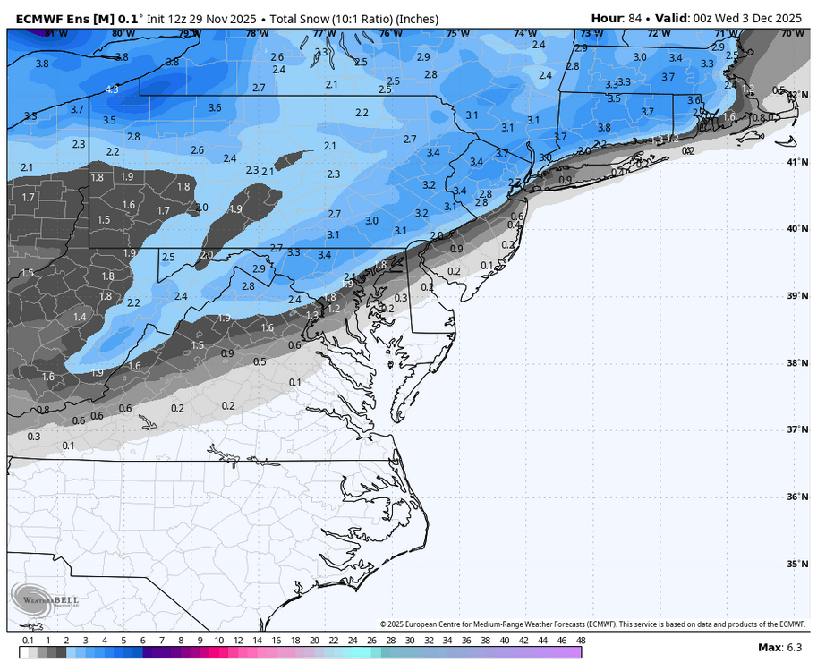
There has never been a larger snowfall on Dec 2nd than 3.9" which happened in 1929 (NYC data). Another similar event was 3.8" 2nd-3rd 1903. The daily records for 1st to 3rd are 1.5" (1880), 3.9" (1929) and 3.0" (1903). A somewhat larger 8" snowfall happened on 4th of 1957 but early December does not have much going for it in the heavy snow department, Nov 30 1882 did better than all of those efforts (8" plus another inch on Dec 1). Maybe before records began in 1869 there was something bigger. I found several instances of severe cold in this part of the early winter that did not bring much snowfall, for example 1875 and 1926. (this is not meant to offer any sort of prediction, I am just looking at the guidance for this event for the first time now)
-

First Winter Storm to kickoff 2025-26 Winter season
TauntonBlizzard2013 replied to Baroclinic Zone's topic in New England
I mean, I’m waiting for it to pull the rug out, and it keeps doubling down -

First Winter Storm to kickoff 2025-26 Winter season
ORH_wxman replied to Baroclinic Zone's topic in New England
A 2 to 1 blend in favor of Euro would actually be one of the few ways we get widespread 4-8” amounts across a lot of SNE into CNE. Maybe we’ll actually catch a knife’s edge in our favor this time. Would be nice juju to start the season after the last several years. -

First Winter Storm to kickoff 2025-26 Winter season
Torch Tiger replied to Baroclinic Zone's topic in New England
if you live in the hilly countryside maybe, but i'm not anticipating more than 1-2" of slop at 150' -

2025-2026 ENSO
Stormchaserchuck1 replied to 40/70 Benchmark's topic in Weather Forecasting and Discussion
This isn't a real strong Stratosphere warming so far -

First Winter Storm to kickoff 2025-26 Winter season
ineedsnow replied to Baroclinic Zone's topic in New England
Same here.. curious to see if the 18z EPS moves north at all -

First Winter Storm to kickoff 2025-26 Winter season
40/70 Benchmark replied to Baroclinic Zone's topic in New England
It wasn't a serious post. -

First Winter Storm to kickoff 2025-26 Winter season
Ginx snewx replied to Baroclinic Zone's topic in New England
You posted it without any caveats, not a mind reader although we can read Scooters prepost -

First Winter Storm to kickoff 2025-26 Winter season
40/70 Benchmark replied to Baroclinic Zone's topic in New England
As long as I get like 4", I'll be fine...but less than that, I'll probably have an early melt. -

Nov 28-30th Post Turkey Day Winter Storm
donsutherland1 replied to Chicago Storm's topic in Lakes/Ohio Valley
-

First Winter Storm to kickoff 2025-26 Winter season
ORH_wxman replied to Baroclinic Zone's topic in New England
Euro would be nice for interior SE MA. Wonder if Brett can whine his way to a warning event. -
First Winter Storm to kickoff 2025-26 Winter season
dryslot replied to Baroclinic Zone's topic in New England
The euro is trash, Toss. -

2025-2026 ENSO
Stormchaserchuck1 replied to 40/70 Benchmark's topic in Weather Forecasting and Discussion
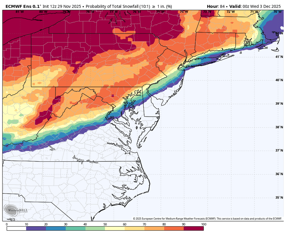
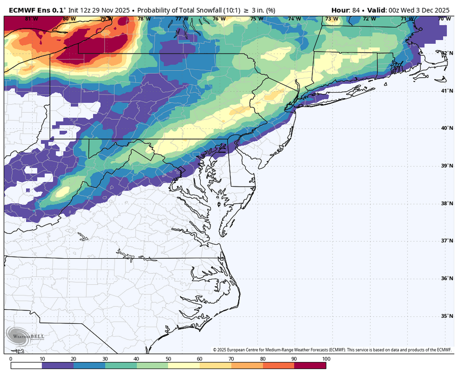
That model is too cold.. it has me >30% of having 3"+.. it's going to be rain here. There is a storm around 12-6 though, and maybe another later on. -

First Winter Storm to kickoff 2025-26 Winter season
40/70 Benchmark replied to Baroclinic Zone's topic in New England
The reason you have this impression is because it's run more often now, which provides more opportunity for error, but it is actually more accurate in the mean. -

First Winter Storm to kickoff 2025-26 Winter season
Damage In Tolland replied to Baroclinic Zone's topic in New England
-
-

First Winter Storm to kickoff 2025-26 Winter season
WinterWolf replied to Baroclinic Zone's topic in New England
Sorry, das Bullshit! Compared to what it was 8 yrs ago, the Frieken thing blows now! Period! -

First Winter Storm to kickoff 2025-26 Winter season
40/70 Benchmark replied to Baroclinic Zone's topic in New England
Don't worry, it will consolidate into a blizzard in time for that fat, bald dude to do his obnoxious siren video, and collect another 5,236 followers.


.png.fbfcfc04a394236bc067d05293c8c1a0.png)


