All Activity
- Past hour
-

E PA/NJ/DE Winter 2025-26 Obs/Discussion
Ralph Wiggum replied to LVblizzard's topic in Philadelphia Region
NS is screaming! Maybe we can cash in on a good old fashioned Saskatchewan Screamer -
Next weekend feels like it's gonna hurt feelings more...it looks like the makings of a potential Miller Too Late storm that could give some in the northeast their first warning snowfall in awhile. But I could be wrong, though
-

Winter 2025-26 Short Range Discussion
Chicago Storm replied to SchaumburgStormer's topic in Lakes/Ohio Valley
-
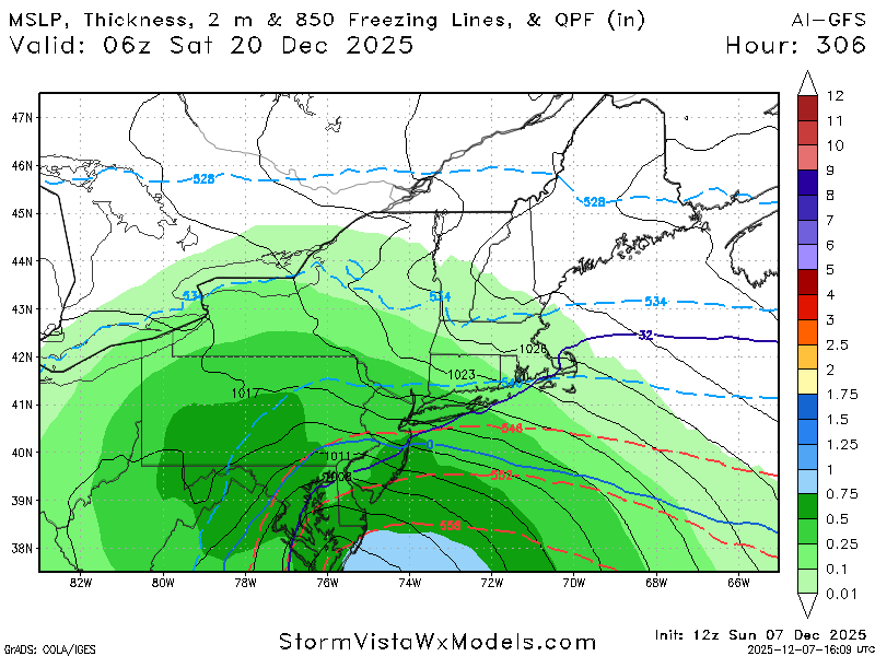
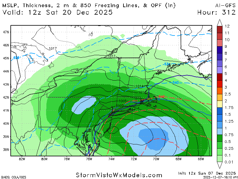
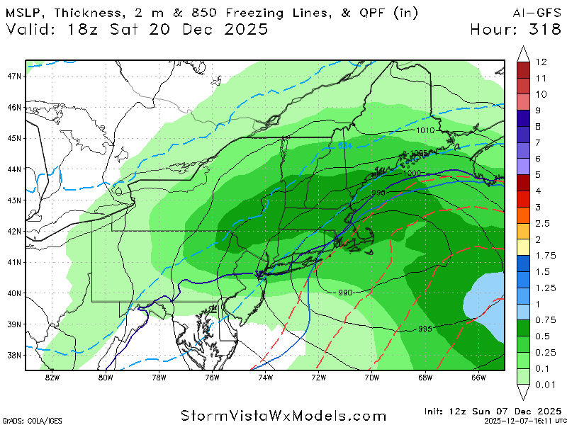
AI GFS
-
Current longer range guidance differs significantly as to what the pattern does just beyond mid-month. ECAI wants nothing to do with any kind of a notable moderation in temperatures. It keeps the cold locked and loaded through Christmas. Other guidance relaxes the cold but nothing suggests any kind of a Christmas torch this year. We'll see. Modeled forecasts of warm ups have been either wrong or muted for the most part since back in October. Snowfall prospects much more uncertain but I'd favor persistence and lean toward possible light clipper / frontal passage events. Don't see any solid evidence at this point in the longer range of anything major 4-8"+. In general I'd favor overall below normal precipitation for the next 7-10 days. Colder and generally dry pattern looks to dominate.
-
Winter 2025-26 Short Range Discussion
Chicago Storm replied to SchaumburgStormer's topic in Lakes/Ohio Valley
-
This is how we roll around these parts. Frustrating, for sure, but it is just the way it tends to be. I suspect that in the middle of the frustration, another, little, surprise event will start to materialize. If not, we go back to chasing pink unicorns in the future. C'est la vie.
-

December 2025 Short/Medium Range Forecast Thread
Daniel Boone replied to John1122's topic in Tennessee Valley
Yep. Snow on snow up that way. -
29.5 with lots of ice around on trees! .
-
Miss one south , then north. Next Fridays clipper has evaporated. Fun times
-

December 2025 regional war/obs/disco thread
DavisStraight replied to Torch Tiger's topic in New England
Usually rain. Looks like a snow game in Buffalo. -
FWIW the 12z GFS a jump north compared to 6z GFS

-
If we have high pressure in place to lock in the cold, everything is suppressed. When the high pressure recedes we get 34 degrees and rain. Dc metro is just brutal for snow lovers. .
-

2025-2026 Fall/Winter Mountain Thread
Maggie Valley Steve replied to Buckethead's topic in Southeastern States
The 12Z GFS solution is coming in with a nice hit..thumb.png.f5a7ed74dd26bbc7821c5a72f1d6d0fd.png)
-

December 2025 regional war/obs/disco thread
WxWatcher007 replied to Torch Tiger's topic in New England
Someone years ago, maybe @donsutherland1, ran an analysis and there’s actually higher precipitation around Dec 25 than other parts of the month. -
Cold morning with -sd's along the shore and -10's inland with some -20's. Heavy sea smoke. Looking forward to some snow action starting tomorrow.
-

Dec 6-7th (It's not a clipper) Clipper
michsnowfreak replied to Chicago Storm's topic in Lakes/Ohio Valley
Deepest snow in chicago in nearly 5 years. Congrats, im jealous! -
just like last winter
-
Which are y’all going with for Saturday’s (12/13) low? The GFS sticks out as much colder than the others at ATL with upper teens there, which tells me it’s likely too cold there. It has had a cold bias over snowcover in recent years (which is well above average in the Midwest). That’s probably a factor as I don’t know that that has been fixed. 6Z GFS: pipe busting cold with upper teens ATL/RDU: likely too cold 0Z Euro: slower with the cold and thus is much warmer on Sat AM with upper 30s: likely too warm though it has 20s the subsequent few days 0Z ICON: mid 20s RDU to upper 20s ATL: looks like a reasonable middle-ground 0Z CMC: coldest at RDU with mid teens (CMC has a well-known cold bias) though only down to mid 20s ATL 0Z UKMET: only down to low 30s though it has a warm bias/very likely too warm though it is headed for 20s on Sunday
-

December 2025 regional war/obs/disco thread
SouthCoastMA replied to Torch Tiger's topic in New England
The ICON evolution verbatim is what I fear with the mid month storm, if we are talking possibilities. West coast ridge collapses, and the trough in east doesn't dig much. And the storm develops late well east of Maine. Let's see what the big boy models show Edit: I guess I was looking at the 14th.. The storm on the 12th looked a bit more promising though still well east and late developing Hopefully we hit on one of em! -
I’m not using Dec 2022 as a heavily weighted analog because of snowcover. On this date in 2022, there was only 1% snowcover in the Midwest: Compare that to today’s 46%, the 3rd highest only to 2013’s and 2007’s 53% and just ahead of 2005’s 45%. The 2003-24 average is only ~15% meaning today’s is ~3 times the average: https://www.nohrsc.noaa.gov/nsa/index.html?region=Midwest&year=2025&month=12&day=7&units=e
-
Anyone have southern Va/northern NC on their to get more snow than us in December poll? Lol
-
Good radiational cooling last night, hit 23 here. Meanwhile UHI had temps mostly above freezing in the city as suburbs were in the teens and twenties.
-
I hope you're right but I hope everyone cashes in and maxes out. I'm thinking I'm not going to be able to make it from Beech to Johnson City for an appointment tomorrow lol.
-
Most of the places where nyc's reservoirs are don't have storm water drains. It's all culvert on natural ground so it just gets soaked into the dirt.


.png.d2823165dddbb7e42894683ae76f38a9.png)


