All Activity
- Past hour
-
This secondary push of cold air is legit. Mesonet soil temperatures west of the suburbs are about to dip into the upper 30s.
-
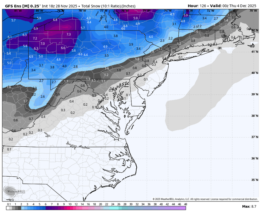
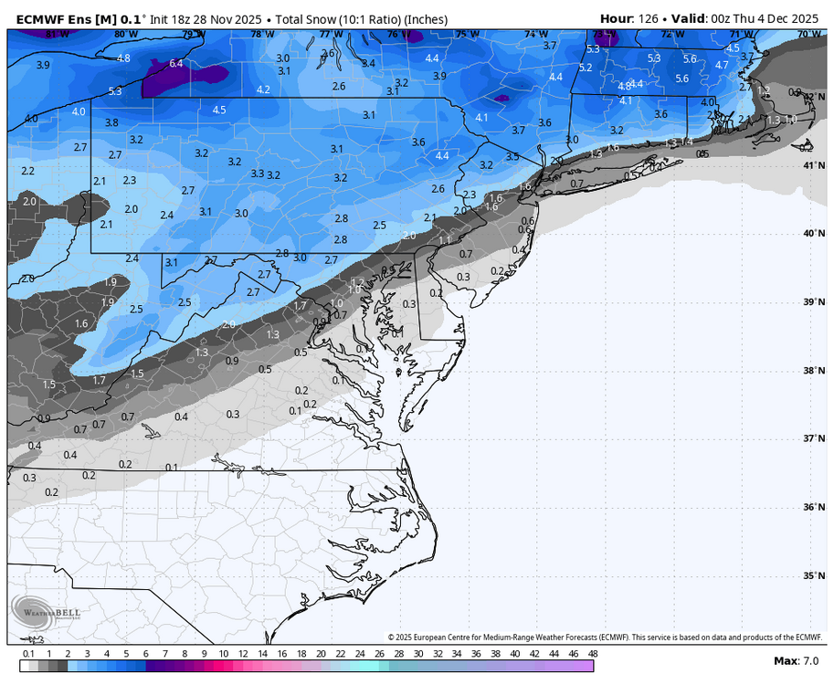
Gonna put this here too.. The uber northwest all rain solution just seems unlikely to me
-
E PA/NJ/DE Autumn 2025 Obs/Discussion
simbasad2 replied to PhiEaglesfan712's topic in Philadelphia Region
Maybe I sound weenie but I'll say it: When the Euro and GFS disagree on a storm like this, 9 times out of 10 the Euro will end up being correct -

Nov 28-30th Post Turkey Day Winter Storm
cyclone77 replied to Chicago Storm's topic in Lakes/Ohio Valley
DVN going all in with amounts generally 13 inches or more in the point forecast at locations near the QC. I would probably play it a bit more conservative with 8-12 with isolated higher amounts. Kind of splitting hairs though really as once you get over 8 inches it's a lot of snow regardless. -
-

Central PA Fall Discussions and Obs
Itstrainingtime replied to ChescoWx's topic in Upstate New York/Pennsylvania
I think someone else should post MU'S thoughts for each winter event this season. That way I'm not always the bad guy. Suffice to say, he's not onboard for Tuesday for the LSV. He's expecting a significant move north with the storm track leading into the event, citing climo, the axis of the ridge out west plus an unfavorable NAO. -
This idea of the cold not being locked in and the high moving east was the theme of the winter last few years so nothing has really changed for this year yet outside of below normal temperatures right now.
-

Central PA Fall Discussions and Obs
Superstorm replied to ChescoWx's topic in Upstate New York/Pennsylvania
Euro . -

Nov 28-30th Post Turkey Day Winter Storm
Harry Perry replied to Chicago Storm's topic in Lakes/Ohio Valley
For real. I’d like to think the overnight shift would come in and hoist a warning for their entire area with the exception of maybe Huron, Tuscola and Sanilac counties. EDIT: Actually after checking over that way, nah.. warning area wide would be wise. 6-8” all the way up to Port Austin. - Yesterday
-

First Winter Storm to kickoff 2025-26 Winter season
dendrite replied to Baroclinic Zone's topic in New England
How about NYC? Asking for a friend. -

First Winter Storm to kickoff 2025-26 Winter season
MJO812 replied to Baroclinic Zone's topic in New England
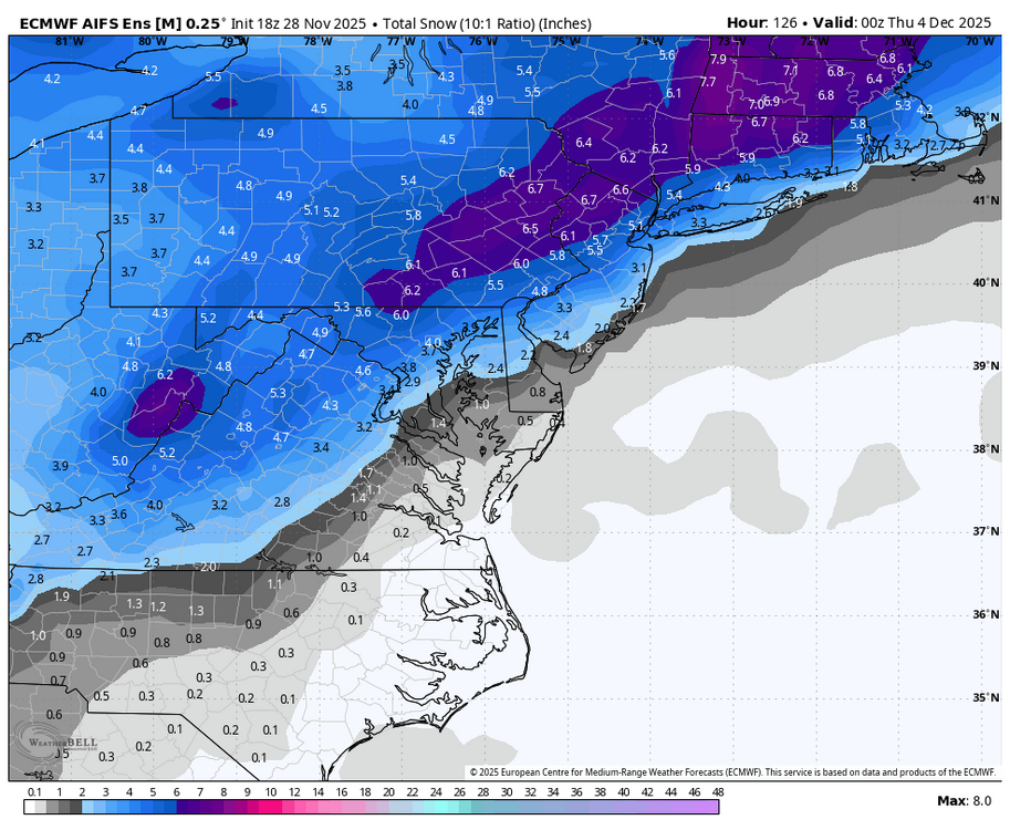
18z euro AI eps gives the coast and inland a few inches. -
First Winter Storm to kickoff 2025-26 Winter season
dryslot replied to Baroclinic Zone's topic in New England
Missed it by 6-7 miles? -

First Winter Storm to kickoff 2025-26 Winter season
dendrite replied to Baroclinic Zone's topic in New England
TAN jacked and Foxboro grazed? -
First Winter Storm to kickoff 2025-26 Winter season
Snowcrazed71 replied to Baroclinic Zone's topic in New England
At this point, I won't be disappointed if we don't get snow Tuesday, although it would be nice. I'm more intrigued on which camp is going to be correct, GFS or Euro and its crew. -
First Winter Storm to kickoff 2025-26 Winter season
dryslot replied to Baroclinic Zone's topic in New England
Translation: Euro would get most of EMATT on the board. -

First Winter Storm to kickoff 2025-26 Winter season
CoastalWx replied to Baroclinic Zone's topic in New England
Insane differences -

First Winter Storm to kickoff 2025-26 Winter season
dendrite replied to Baroclinic Zone's topic in New England
Looks like tomorrow morning. RAOBs are closer to 11z though so I would feel more confident with the 00z runs tomorrow. -

First Winter Storm to kickoff 2025-26 Winter season
TauntonBlizzard2013 replied to Baroclinic Zone's topic in New England
Euro would get most in SNE on the board -
First Winter Storm to kickoff 2025-26 Winter season
Snowcrazed71 replied to Baroclinic Zone's topic in New England
What's the snow map look like with this latest run? -
MJO Phases 7 & 8 & both really good as you move into DEC. Phase 6 is good in DEC until 2nd half of DEC. Phase 7 & 8 gets better each week as you progress into DEC. Phase 7 starts getting worse as you get into JAN. https://www.atmos.albany.edu/facstaff/roundy/waves/rmmcyc/index200reg.html
-
First Winter Storm to kickoff 2025-26 Winter season
UnitedWx replied to Baroclinic Zone's topic in New England
I hate to be that guy, but when is this wave onshore for better sampling, tomorrow afternoon? -
Natester started following Nov 28-30th Post Turkey Day Winter Storm
-

First Winter Storm to kickoff 2025-26 Winter season
dendrite replied to Baroclinic Zone's topic in New England
-
Central PA Fall Discussions and Obs
pawatch replied to ChescoWx's topic in Upstate New York/Pennsylvania
Just as long as we can keep the cold, it looks promising. 45 mph gusts today…definitely not normal wind.


