All Activity
- Past hour
-
.thumb.png.4150b06c63a21f61052e47a612bf1818.png)
July 2025 Obs/Disco ... possible historic month for heat
HIPPYVALLEY replied to Typhoon Tip's topic in New England
i’m sure the few cells popping south of Albany will get shredded coming through the Berkshires. -

July 2025 Obs/Disco ... possible historic month for heat
rclab replied to Typhoon Tip's topic in New England
Perhaps a name change to NYC Sanctuary forum might be needed. As always …… -
Sligo creek about 450 feet from me came out of its 6-7’ banks and flooded up to 300 feet away on the level ground side, I’m at elevation, to a depth of 2-3’ right at the bank and up to 300 feet away was 6-12” deep. Last time anything like this leither 2006 or 07 just can’t remember which
-

July 2025 Obs/Disco ... possible historic month for heat
Lava Rock replied to Typhoon Tip's topic in New England
Waiting to light it up at the marina Sent from my SM-S921U using Tapatalk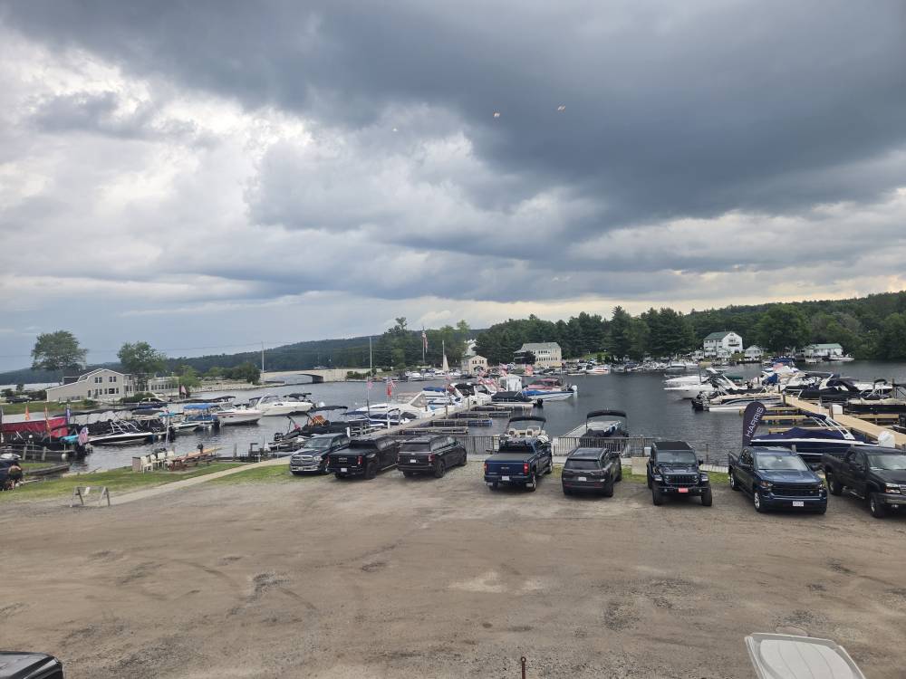
-
FML... Don't know whether to , , or
-
The heavy rain went around me this morning, so I only got 0.25". This weekend's two MCSs only produced 1.18" here, which is a bit disappointing.
-

July 2025 Obs/Disco ... possible historic month for heat
weatherwiz replied to Typhoon Tip's topic in New England
NESN is pricing itself out. I think Xfinity dropped them in Connecticut. I have to use stupid streaming sites when I watch the Bruins or want to watch the Red Sox (though I mostly just follow game day for the Sox). NESN360 is $30/month what an absolute ripoff. -

Occasional Thoughts on Climate Change
Typhoon Tip replied to donsutherland1's topic in Climate Change
Very good 'plain English' written article containing veracious principles of Meteorology and climate, from (surprisingly) CNN source: https://www.cnn.com/2025/07/20/climate/summer-of-flooding -
July 2025 Obs/Disco ... possible historic month for heat
weatherwiz replied to Typhoon Tip's topic in New England
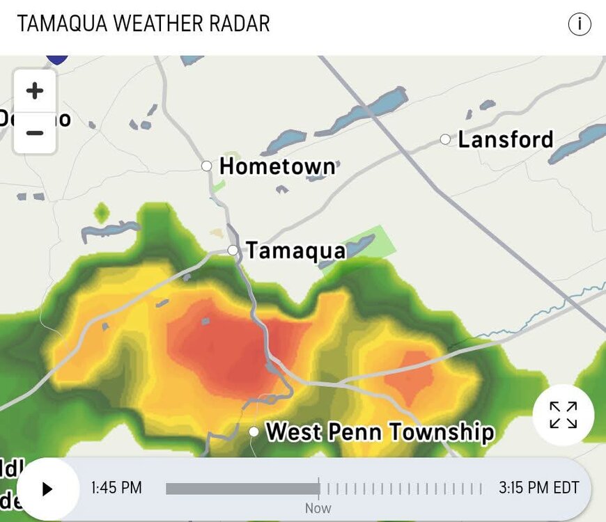
Should be getting an MCD soon I would think -

July 2025 Obs/Disco ... possible historic month for heat
dendrite replied to Typhoon Tip's topic in New England
This is the exact reason CT should be moved to the NYC forum. -

July 2025 Obs/Disco ... possible historic month for heat
powderfreak replied to Typhoon Tip's topic in New England
Burlington gets NESN for sports and Plattsburgh gets YES. That’s how you know . -

July 2025 Discussion-OBS - seasonable summer variability
steve392 replied to wdrag's topic in New York City Metro
Wife said a downpour just happened at home. -

July 2025 Obs/Disco ... possible historic month for heat
kdxken replied to Typhoon Tip's topic in New England
Neither is Burlington. It's a suburb of Plattsburgh. Hop, skip, and a ferry. -

July 2025 Obs/Disco ... possible historic month for heat
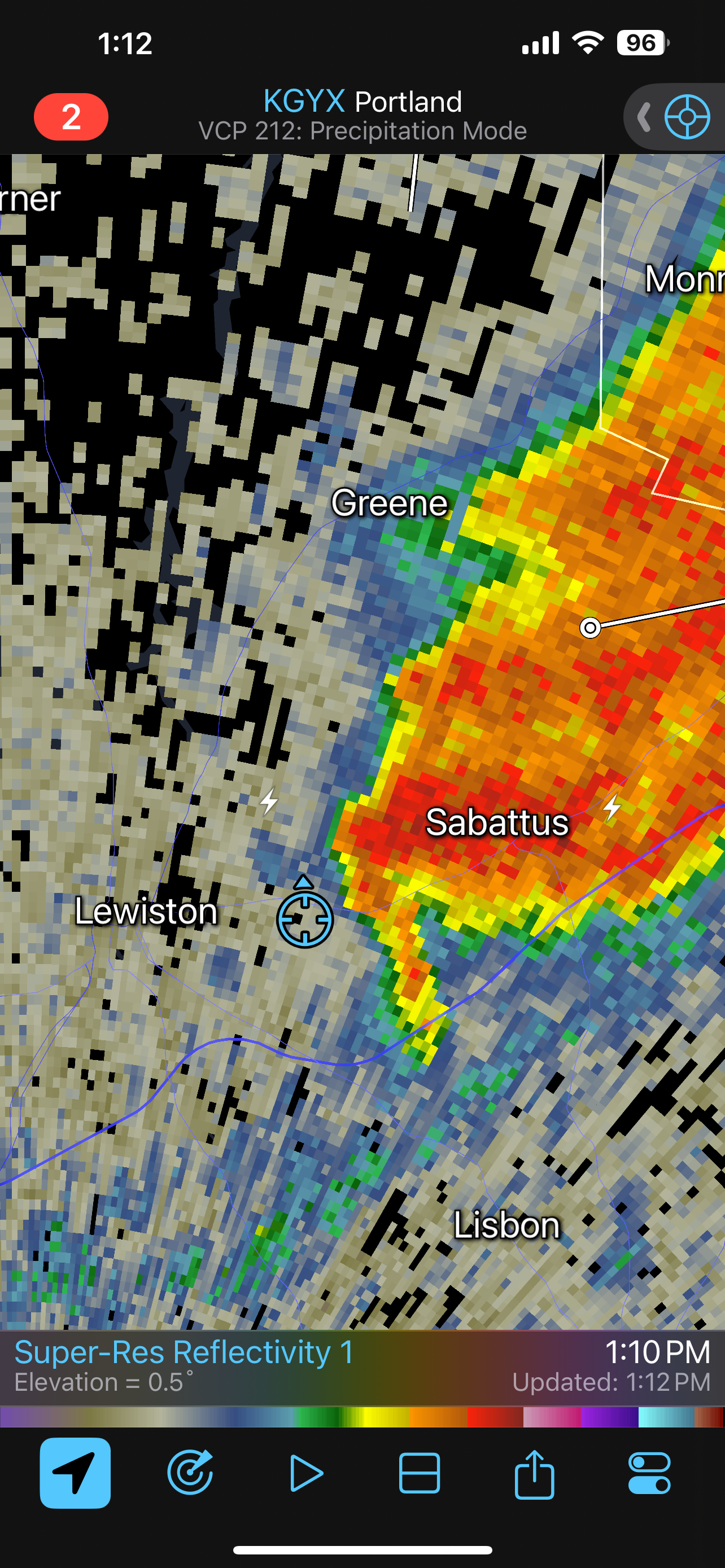
dryslot replied to Typhoon Tip's topic in New England
Cell blew up once it passed here.
-
Thanks for the kind words. I'm glad Maryland and its counties are investing in this infrastructure.
-

July 2025 Obs/Disco ... possible historic month for heat
Chrisrotary12 replied to Typhoon Tip's topic in New England
Towers trying back in the Hudson River Valley but nothing too successful yet. -

July 2025 Obs/Disco ... possible historic month for heat
Cyclone-68 replied to Typhoon Tip's topic in New England
Northeast... Weak to moderate instability is forecast to develop across the Northeast through mid afternoon as the airmass continues to destabilize. Midday surface analysis indicates temperatures are warming into the 80s with dewpoints in the upper 60s to lower 70s. As the cold front advances east into this uncapped airmass, scattered thunderstorms should develop. Shear of 30 to 35 knots and relatively long/straight hodographs will support the potential for supercells. Weak mid-level lapse rates will be the primary limiting factor for large hail, but the overall favorable shear with strong venting aloft and potential supercells may support some isolated large hail. Damaging wind gusts will be the primary threat, both from initial cells and also from any clusters which develop. Any stronger clusters with bowing segments could support a better organized damaging wind swath. The greatest wind damage threat will likely exist from western Massachusetts to far southern Maine. -
July 2025 Obs/Disco ... possible historic month for heat
Chrisrotary12 replied to Typhoon Tip's topic in New England
No wonder why I hate summer now. - Today
-

July 2025 Discussion-OBS - seasonable summer variability
SACRUS replied to wdrag's topic in New York City Metro
See if anything concentrates in PA as cold front pushes eats -
July 2025 Discussion-OBS - seasonable summer variability
SACRUS replied to wdrag's topic in New York City Metro
Yes, cleared out around noon here and up to 89 now -
July 2025 Discussion-OBS - seasonable summer variability
SACRUS replied to wdrag's topic in New York City Metro
1PM Round up EWR: 88 ACY: 88 New Brnswck: 88 PHL: 87 NYC: 86 BLM: N/A sensor down TEB: 86 JFK: 85 ISP: 85 LGA: 85 TTN: 84 -

July 2025 Obs/Disco ... possible historic month for heat
bristolri_wx replied to Typhoon Tip's topic in New England
Answering my own question: https://rapidrefresh.noaa.gov/hrrr/MPAS/ -
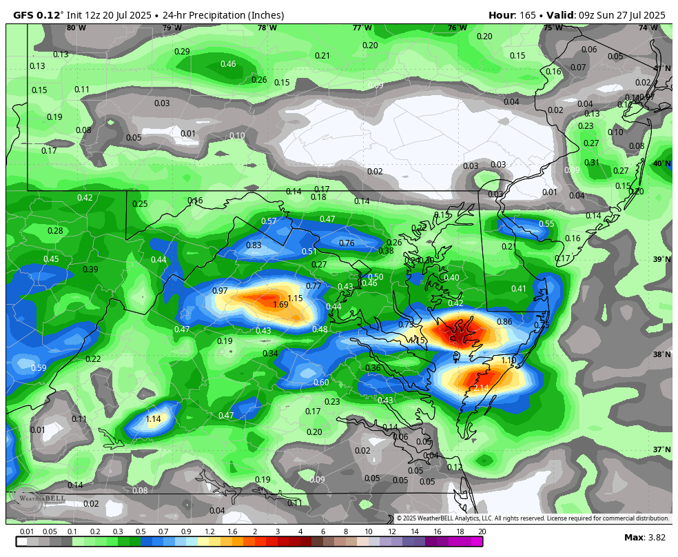
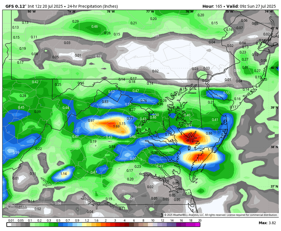
WB 12Z GFS, dry work/ beach week ahead....next chance of rain on Saturday.
-
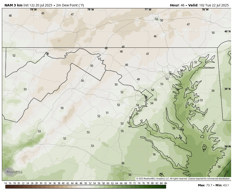
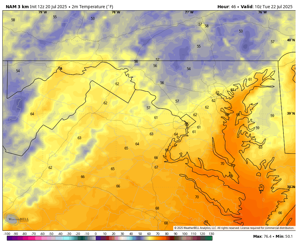
As advertised, September like mornings coming! Below, WB 3K NAM for Tuesday. Enjoy!!!


-
The lightning in these storms around TRI has been insane. We have definitely been catching a break with more rain than we have been getting. TRI seems to dry out during July-October...so we take what we can get. What Helene did was super similar to what happened in the Smokies many years ago when the road between the Y and Gatlinburg was wiped out. I am beginning to think these events are slightly more common than once thought. Buffalo Mountain had a catastrophic flood just out of the blue several years ago.