All Activity
- Past hour
-

November 2025 general discussions and probable topic derailings ...
powderfreak replied to Typhoon Tip's topic in New England
Daily snows. Dark November afternoons.
-
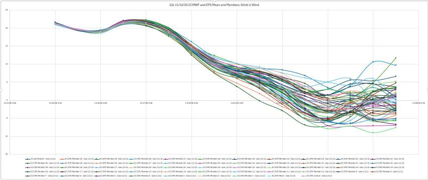
Great stuff from Allan Huffman. Today's 12z op ECMWF and EPS mean both show the 10mb U wind turning negative, meaning a change to an easterly wind direction over the polar regions and an #SSWE with 41 of 50 EPS members (82%) showing this reversal with 11/25 the day with the most negative members. Sudden Stratospheric Warming Events, can weaken the tropospheric polar vortex, allowing for increased high latitude blocking (-AO) and the enhanced risk for arctic air discharge into the mid-latitudes (North America, Europe, East Asia). A late November SSWE is relatively rare, and COULD help favor a cold start to meteorological winter(December). The last November SSWE was in 1968. Sent from my SM-G998U using Tapatalk
-

November 2025 general discussions and probable topic derailings ...
WinterWolf replied to Typhoon Tip's topic in New England
Lol…Guy is Jacked! -
^-5° for Jan would be legit cold
-
 We don't know exactly what drives an advisory--- and OKX and PHI may say it wasn't warranted for areal coverage etc. Who knows... My goal for the post was that the flurry situation was well documented as first for the season, AND, that the Blend of Models and most, if not all other modeling gust tools were inferior to the ECMWF gust tool. This is twice in succession that I've noticed the ECMWF has excelled one 40kt or greater gusts, even overcoming NAM and GFS limited R# (eddy) transfer for the 11/11 event. If all other models show 40KT plus gusts inclusive of the SPC HREF, better issue the advisory. If most don't...hesitate. Power outages increased for a time in NJ but not equivalent to the 31st when the trees were more fully leaved the gust criteria was exceeded even in the interior.
 -
Incredible how reliable that December snowfall statistic is in the park.
-
Haven’t even begun to think about it yet. But I do appreciate the vapid airhead commentary as always
-
When I look at last year's snowfall it seems pretty normal outside of the anomalous Gulf Coast snow. Sure we got more snow in Calvert county than Baltimore but that was really just luck from one storm and it due to climate shift. At least that's my take.
-
It's unfortunate happenstance that some spots further south are on a bit of a "run" (though I doubt if you asked the SE thread folks, they'd think they've been on a heater) but in the greater timescale of recorded meteorological history the streak you refer to is a blip. It'll average back out in the averages eventually.
-
CME is about to hit within 20-30 minutes as of this post.
-
CME is about to hit within 20-30 minutes as of this post.
-
(002).thumb.png.6e3d9d46bca5fe41aab7a74871dd8af8.png)
Central PA Fall Discussions and Obs
ChescoWx replied to ChescoWx's topic in Upstate New York/Pennsylvania
I have continued to update the Chester County Weather website and have now completed and added a listing of the largest Chester County snowstorms across the 7 months of the year - October through April that we have recorded snow events. https://chescowx.com/top-snowfalls-by-month/ this includes the 2nd largest snowstorm in County history that occurred in March 1958 when between 19" to as much as 50" of snow fell across Chester and SE Berks Counties. See below. -
E PA/NJ/DE Autumn 2025 Obs/Discussion
ChescoWx replied to PhiEaglesfan712's topic in Philadelphia Region
I have continued to update the Chester County Weather website and have now completed and added a listing of the largest Chester County snowstorms across the 7 months of the year - October through April that we have recorded snow events. https://chescowx.com/top-snowfalls-by-month/ this includes the 2nd largest snowstorm in County history that occurred in March 1958 when between 19" to as much as 50" of snow fell across Chester and SE Berks Counties. See below. -

November 2025 general discussions and probable topic derailings ...
weatherwiz replied to Typhoon Tip's topic in New England
I really hope something changes moving through December. But I hope this really isn't another year of major wave breaking along the West Coast that pumps up a massive ridge across the eastern third of the country and we just see cutting/weakening storms as the approaching trough lifts out then we get several days of cold/dry on the backside of the systems and just rinse and repeat as the next wave break occurs and the next ridge builds. I think a month or two ago I made some comments that I didn't think ENSO will be a big player in the overall regime but kind of looking ahead...I actually wonder if (regardless of what ENSO indices show) the hemispheric pattern this winter may be reflective of what you would see in a stronger Nina event. -
Link doesn't work.
-
So are we gonna have an epic winter with big snows or is it gonna be cold, dry and windy? That's the question.
-
We've gotta get old fashioned sustained blocking back. If so, those averages will increase.
-
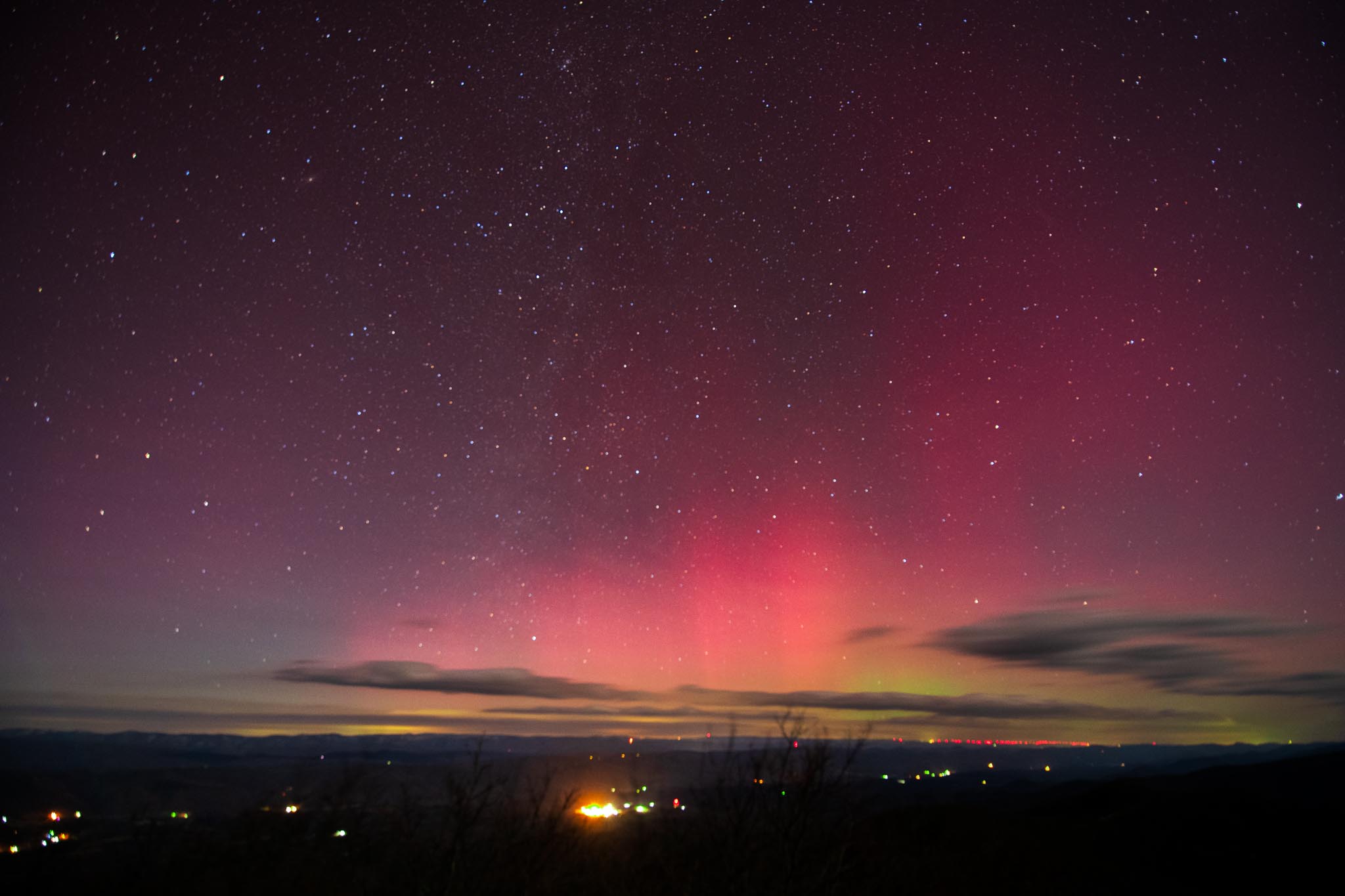
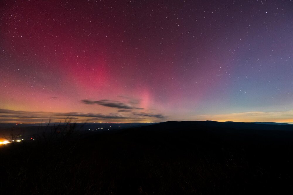
Do all of that and that’s how to get a shot like these! (From WV/VA border and 4000+ ft at 12:30am)

-
Maybe, Kammerer is right
-
November 2025 general discussions and probable topic derailings ...
WinterWolf replied to Typhoon Tip's topic in New England
Lol. The Sanfrancisco treat. -
Maybe, Doug Kammerer is right
-
82%. Nice.
-
As a photographer enthusiast all you really need is 1. Tripod 2. 10 second shutter 3. Lowest f stop possible lens (2.8 is good) 4. 1600-3200 iso 5. preemptively use manual focus on a distant light to ensure your focus is good! Happy photographing!
-
 Would that be because of the government shutdown? I'm frankly impressed that so many services are still functioning, the Weather Service in particular.