All Activity
- Past hour
-
Today's 8-14 analog package from CPC... 19611207 20001106 20001111 19521122 19831124 19671210 20041119 19981106 19711115 19691110 The one that really stands out is the 83-84 winter due to the cold which came early during that winter. It was just brutal. I remember riding to town in our Toyota, and the windows froze up on the inside! @John1122will have to fill in the blanks for the 1960s. Generally, if I see winters from the 1960s showing up...those are gonna have some decent analogs(not all). We may have some others with knowledge of those winters as well. Keep in mind, these analogs are centered on a warm time frame. So, let's see where these go as we get deeper into winter, and see if we see a particular analog which survives from week to week.
-
(002).thumb.png.6e3d9d46bca5fe41aab7a74871dd8af8.png)
Central PA Fall Discussions and Obs
ChescoWx replied to ChescoWx's topic in Upstate New York/Pennsylvania
Climate factoid of the day. Someone posted last week that it seems like it never snows before Christmas here in Chester County. So, I went back and looked to see how often we have not recorded any measurable snow by Christmas Day. The data shows we actually have seen measurable snow 92% of the time before Christmas. There have only been 11 years across 132 years of record that no station in the county recorded measurable (more than a trace) of snow. Those years were 1899 / 1918/ 1956 / 1965 / 1974 / 1991 / 1999 / 2001 / 2006 / 2015 and 2021. -
E PA/NJ/DE Autumn 2025 Obs/Discussion
ChescoWx replied to PhiEaglesfan712's topic in Philadelphia Region
Climate factoid of the day. Someone posted last week that it seems like it never snows before Christmas here in Chester County. So, I went back and looked to see how often we have not recorded any measurable snow by Christmas Day. The data shows we actually have seen measurable snow 92% of the time before Christmas. There have only been 11 years across 132 years of record that no station in the county recorded measurable (more than a trace) of snow. Those years were 1899 / 1918/ 1956 / 1965 / 1974 / 1991 / 1999 / 2001 / 2006 / 2015 and 2021. -
If you can get the NH version of North Woods Law (much more numerous than the Maine ones), every 2-3 episodes you would probably see a warden/rehab contact. Almost all have a happy ending, though one cannot know which contacts get onto the show. The NH Warden Service could likely point you to rehabber locations. A Trace is just snow falling and either melting on contact or less than anything measurable. So yes, you had that, but nothing measurable yet. I've had up to 0.3" of wispy snow that melted out to less than 0.005", thus a trace. Not common and it looks odd, but I've not found a better way to report. Edit: Moved the snowblower out of the shed and set out the snow stake. Hope that doesn't scare off Sunday's event.
-

November 2025 general discussions and probable topic derailings ...
dryslot replied to Typhoon Tip's topic in New England
Sauteed and simmered, The flavor can't be beat. -
We're going full pleistocene baby! Apologies to northern Michigan though.
-
I just saw it. Right you are and by a good margin!! Mean minimum down to ~0:
-
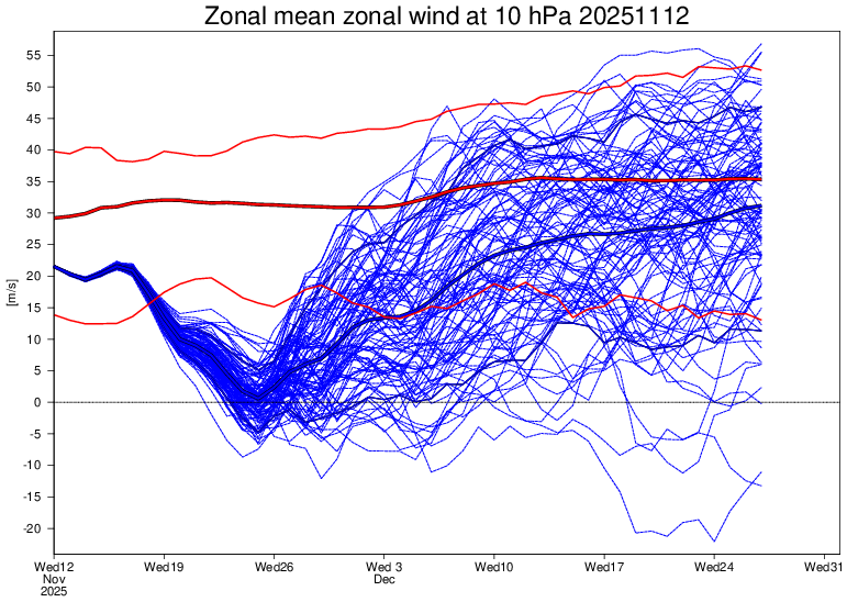
Wow indeed 82 percent now!!! Today's 12z op ECMWF and EPS mean both show the 10mb U wind turning negative, meaning a change to an easterly wind direction over the polar regions and an #SSWE with 41 of 50 EPS members (82%) showing this reversal with 11/25 the day with the most negative members. Sudden Stratospheric Warming Events, can weaken the tropospheric polar vortex, allowing for increased high latitude blocking (-AO) and the enhanced risk for arctic air discharge into the mid-latitudes (North America, Europe, East Asia). A late November SSWE is relatively rare, and COULD help favor a cold start to meteorological winter(December). The last November SSWE was in 1968.
-
That map is Celsius!
-
Yeah the motto is if the Bz doesn't flip you won't see shit.
-

November 2025 general discussions and probable topic derailings ...
WinterWolf replied to Typhoon Tip's topic in New England
Lol…he’s in the reverse psychology phase now. As soon as the first big snow threat comes, he will morph into positive and gung-Ho Kevin. -
Thanks. But to his credit, he backs it up well! Some on the other side don’t back it up as well. As far as myself, I clearly prefer cold and root for it. However, I do my best to post as objectively as possible and not let my preferences affect my posts. So, whereas I enjoy posting about cold, if I see a model that looks warm I won’t be afraid to post it to protect my objectivity. I post whatever I see, cold, warm, neither, etc.
-
I didn't say I expected it to get back to '60's Era. I said the recent averages would increase. Obviously overal warming has taken place, whether Cyclical , environmental or otherwise. I definitely don't believe it's all Greenhouse gasses. I'm not a practicing Met now but, still do some research and still look back on my working days and yes there's been a gradual warming but, we're still getting Snow way South. So, a banner Year in the MA is still very possible.
-
Yeah with that Bz you won't see anything unless it flips negative.
-
Weeklies are still cold and active in the central and east. The latest PV is most likely at its weakest stage yet.
-
yes but thankfully The Old farmers almanac will still be going strong, the forecasts are for entertainment but the gardening tips and astronomical information is top-notch and they have some of the best calendars I’ve seen.
-
Yeah I mean I'm a snow miser like a lot of folks here. I want snow and plenty of it! Why he won't simply admit to being a heat miser when it's so blatantly obvious is beyond me--all our biases are loud and clear
-
95-96 was second best snow winter for ETn in my lifetime behind 93 .
-

November 2025 general discussions and probable topic derailings ...
Lava Rock replied to Typhoon Tip's topic in New England
Kevin disagrees -
@Maestrobjwa I think you’re not getting what I’m saying. One anomalous result in one season at one location is not indicative of a climate shift. It’s just a fluke. Look at 2010. Baltimore got 32” more snow than Albany NY that year. Was that some indication the climate had shifted and Baltimore was snowier than Albany or was it just a one year fluke anomaly?
-
I don’t know how to get that map but I could run the numbers. Give me some cities and I will tell you what their average is v Baltimore over that period. 2018-2025
-
But you picked 3 different locations where in one season they got more snow than Baltimore. One year. Over a longer period (10 years or more) none of those locations had more snow than Baltimore. That isn’t how climate works. One storm in one season is a fluke. If New Orleans got more snow over a 10 year or 30 year period then we can have this conversation.
-
How do I get that map from 2018 through now? That's the time period I really wanna see.
-
I must be misrembering then. I just know southern half has done better than the northern half of our sub since Dec 2018.. It's not one season but multiple ones since then. Precip boundary has been consistently south of here, hasn't it? NoVa has done better as well...but I could be wrong.
-
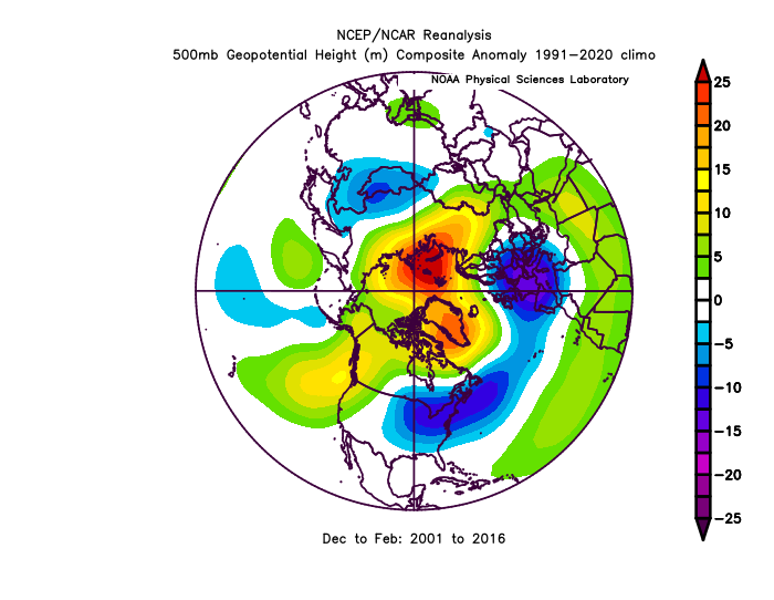
We are due for another negative cycle of the AO/NAO. However, don’t assume that fixes 100% of this. We had a very favorable long term cycle of the NHem long wave pattern from 2001-2016 and the sad fact was the mid Atlantic only has “average” snowfall during that period. NYC and Boston were setting all kinds of snowfall records though! This period was very similar to the pattern of 1958-1971 but the positive snowfall anomalies shifted further north and we were south of most of the snow. Similarly we were due for another god awful period with an unfavorable PDO/AO coinciding, but just like the last favorable cycle didn’t produce as much snow as previous ones, this bad cycle is producing even less snow than previous ones. So yes we will get a better period sometime with a run of a more favorable PDO and AO and it will snow more than it has the last 10 years. But don’t expect it to suddenly go back to what the results were in the 1960s or even what they were in the 2000-2016 period. The downward degradation of our snowfall will continue with shorter term highs and lows within the longer scale trend. Below was our mean Dec-Feb h5 from 2001-2016 and yet all we got from this was near mean snowfall. We should have been way above avg snow (like NYC and Boston were) with this pattern.