All Activity
- Past hour
-
Richmond is still on the lower side, but there’s so many options still in guidance. We’ll see what solution they converge to. It’s insane how far southern Virginia has been the place to be recently.
-
We escaped last year, but I'm not feeling good about this year Sent from my SM-S921U using Tapatalk
-
Models have been pretty inconsistent outside of 3-4 days; let’s see how things progress this week. My concern is at some point (at least Pike South) we are going to lose the consistent normal to below normal temps we have had the last 3-4 weeks
-

Richmond Metro/Hampton Roads Area Discussion
migratingwx replied to RIC Airport's topic in Mid Atlantic
Short range models are looking really good for you guys. Could be a nice 2-4" event for many tomorrow. -
He has 1K threes more then anyone else in NBA history.
-
As a Tech Alum, couldn’t have happened to a better group of folks.
-
Looks like a decent inversion. Thurmont mesonrt site never dipped below 33°, but the low lands all got into the 20s. I just bumped into the low 30s once the sun came up.
-

December 2025 regional war/obs/disco thread
WinterWolf replied to Torch Tiger's topic in New England
I didn’t say that…I said it’s better that the signal is there and growing, than have some bomb that will come and go at this lead. Just like 18z GFS yesterday…it was gone next run. It’s a timeframe of interest is the point, where tele’s and the long wave pattern seem to be converging. I feel it better this at 6-7 days away, the threat will emerge/re-emerge. But nice try…you are one spooning mofo. Sad. -

2025-2026 Fall/Winter Mountain Thread
Maggie Valley Steve replied to Buckethead's topic in Southeastern States
The 12Z 3km NAM suggests 2 to 3 inches here in the Valley. Even Asheville gets snow! That models continues to suggest a good 24+ hours of light snow in Haywood County. Is it enough for GSP to expand the WWA this afternoon?.thumb.png.d0bc842baddcec925f3b2b79aa125dfc.png)
-
Don’t worry, we have snow to track at least!
-
Dec 6-7th (It's not a clipper) Clipper
migratingwx replied to Chicago Storm's topic in Lakes/Ohio Valley
Another great event to add on to what we had. The timing of the event was unfortunate, with it happening so late into the night and wrapping up around sunrise, I barely got to see some good rates.
-
The brine not only destroys undercarriages of cars it’s terrible for ground water etc.
-

2025-2026 ENSO
donsutherland1 replied to 40/70 Benchmark's topic in Weather Forecasting and Discussion
If the WPO relaxes from its forecast values of -2.000 or below, other teleconnections can gain influence over the pattern. The EPS currently forecasts an EPO+/AO+/PNA-/NAO+ regime toward the end of its run. If the WPO rises, that could allow ridging to expand across the CONUS with warmth following after a few days lag. December 30-31, 1999: The December 30-31, 1999 composite 500 mb map is one example of how unfavorable teleconnections overwhelmed a weaker WPO-. Then, the WPO was still impressive (below -1.000) but it was not at the extreme values necessary to overwhelm the pattern. Milder conditions rapidly spread into the East. Despite much above normal temperatures to start January 2000, the month wound up colder than normal. Late January (January 24-27 timeframe) saw a major snowstorm in the Southeast and lower Mid-Atlantic region. For now, it looks to remain generally colder than normal through around December 20th. Nothing is cast in stone for the remainder of the month, though some temporary relaxation is plausible. IMO, the odds remain against a complete breakdown of the pattern and the onset of a sustained warm pattern during the closing 10-11 days of December. Still, it's worth watching the evolution of the guidance. I suspect that there could be an increased risk of a pattern breakdown after mid-January, which often happens during La Niña winters, but that's in the speculative range right now. The PNA could play a larger role in how January evolves.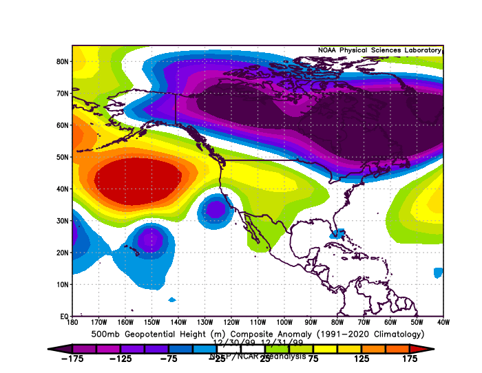
-
That white protruding from PA in western Jersey isn't snow cover, is it?
-

December 2025 regional war/obs/disco thread
Torch Tiger replied to Torch Tiger's topic in New England
Wolfie said its better therr are no bombs to track. Lol already tailgating? -

December 2025 regional war/obs/disco thread
DavisStraight replied to Torch Tiger's topic in New England
The worst was 2007 when we had a great pack and we got a warm pouring rain the 24th into Christmas and wiped out what would have been a great start to winter. -
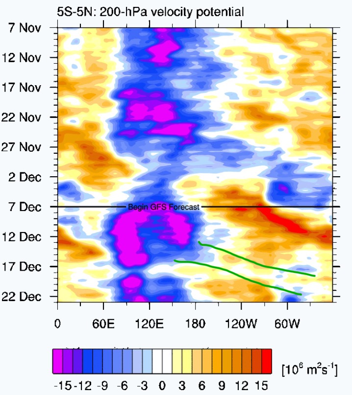
After several 11-15 day warm ups have failed to materialize in the past few months, I remain skeptical of such warm ups in the near future. Of course that will change, and my guess as to when the next extended warm up will be is february. We may get mild for a week or so mid-Dec, but I think its only temporary. I drew in green below the next mjo wave to get out of the MC. There is a hint of this even within the 5N-5S band (its stronger with 15N-15S and thus more influential). So I wouldn’t be surprised to see that hint strengthen into a signal that’ll eventually play out and bring us back to colder weather in late Dec into Jan.

-
Thanks, I think...
-

Central PA Fall Discussions and Obs
Mount Joy Snowman replied to ChescoWx's topic in Upstate New York/Pennsylvania
Low of 29. Taking the kids to see Santa today up in Elizabeth Farms above Brickerville, never been before. Should be a solid winter day. Then a big game between the Packers and Bears. Go Pack! -
To reiterate, there was zero snow on any paved surfaces Saturday morning. They were wet from the MELTED snow. Temps were above freezing when they salted, and would have naturally dried with sun all day and temps over 40 degrees. The only thing the salt did was get in dog's paws, go down the storm drains to give a shock load to the aquatic flora and fauna, increase salt content in drinking water sources, and get underneath your vehichle to initiate corrosion.
-
this month is toast beyond a lucky one off for NYC. Sad for a BN Dec. Enjoy the rain Thursday.
-

Dec 6-7th (It's not a clipper) Clipper
TheNiño replied to Chicago Storm's topic in Lakes/Ohio Valley

-

December 2025 Short/Medium Range Forecast Thread
Holston_River_Rambler replied to John1122's topic in Tennessee Valley
Pretty decent NAMing for parts of SW VA at 12z. Especially areas NE of Abington towards Wytheville. -
Seeing the classic pattern in the high-res models of mountain snow, followed by a piedmont lull, and a NE NC jackpot.
-
Looks like winter this morning, all the trees, grass, and bushes are covered in rime ice, frost, frozen fog


.png.57d5d0d4bd09f77675e6350377c02840.png)