All Activity
- Past hour
-
Yessir! We’re 2 miles N of that line.
-
-

First Winter Storm to kickoff 2025-26 Winter season
78Blizzard replied to Baroclinic Zone's topic in New England
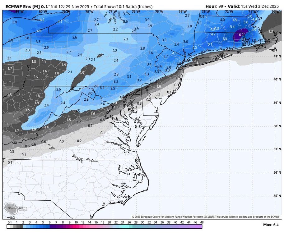
It still looks like the Euro vs the rest of the models. The Euro has never shown a hugger or an inland depiction as opposed to the GFS and Canadian. We'll see. The Euro may be about to become as useless as the NAM at these time periods. -
Yep, pigs get slaughtered.
-

First Winter Storm to kickoff 2025-26 Winter season
CoastalWx replied to Baroclinic Zone's topic in New England
Fairly good amount of spread there too. -

First Winter Storm to kickoff 2025-26 Winter season
Damage In Tolland replied to Baroclinic Zone's topic in New England
We’d all certainly prefer that over the GFS/ GGEM/ NAM camp. Just whiten the landscape before the cold -
Central PA Fall Discussions and Obs
AccuChris replied to ChescoWx's topic in Upstate New York/Pennsylvania
12z Euro AI shows a nice widespread event Tuesday . -
Cold day for UVA v. Tech. Gonna have to represent at Scott anyway. Goooo Hoos!
-
Of course its gone this run. Needing another needle in a haystack to win
-
Stowe didn’t open till 12/3 last year, so absolutely. Pretty busy this weekend! And yeah, I undersold this one too lol. Models weren’t really exciting south of Jay but I was surprised it got as far south as Mansfield. Crazy sharp drop off south of here though.
-

First Winter Storm to kickoff 2025-26 Winter season
ineedsnow replied to Baroclinic Zone's topic in New England
AIFS ENS went wild though -
Nov 28-30th Post Turkey Day Winter Storm
ChiTownSnow replied to Chicago Storm's topic in Lakes/Ohio Valley
Everything on track.. looks to be a little lull in the action and then cranks back up. -
Had a tease for the 6th. Does seem like that the 6th is another “real” window at least. All I can ask for at the start of the season is a few chances to keep me busy.
-
You have been wrong also. Just stop posting please. Why are people still all gloom and doom when the guidance shows a cold and active December ? I dont get this place.
-

First Winter Storm to kickoff 2025-26 Winter season
ORH_wxman replied to Baroclinic Zone's topic in New England
Yes. But prob just advisory snows. -

First Winter Storm to kickoff 2025-26 Winter season
WxWatcher007 replied to Baroclinic Zone's topic in New England
We love 'em but he's lost. John Travolta levels of confusion. This is a light to mod event in his hood. -
It did not lol
-
Nov 28-30th Post Turkey Day Winter Storm
TheNiño replied to Chicago Storm's topic in Lakes/Ohio Valley
St Louis gets no love on this board so thank you for sharing -

Nov 28-30th Post Turkey Day Winter Storm
CheeselandSkies replied to Chicago Storm's topic in Lakes/Ohio Valley
Been steadily snowing all morning in Madison but rates and flake sizes have been fairly run-of-the-mill. Hoping one of those heaver bands can make its way up here. -

Nov 28-30th Post Turkey Day Winter Storm
cyclone77 replied to Chicago Storm's topic in Lakes/Ohio Valley
Nice rippage over the past hour or so. Probably up near 6" now. Still 10+ hours to go. -
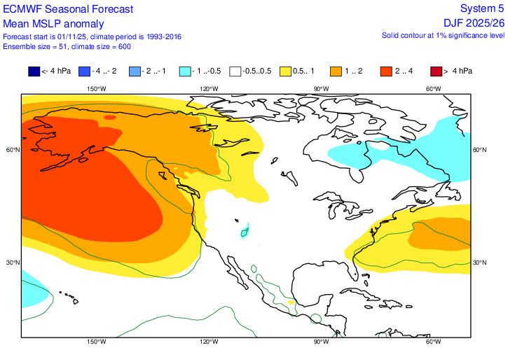
I knew I had seen the surface maps showing surface Highs moving off the coast to our east and NE. I found it. Looks like we may hve to get used to it for the winter if the Euro seasonal is correct. The link below is for the period of Dec-Feb. If you scroll forward to J-M, it's even stronger. As long as we get better cold into the area, we should still have our shots at snow. Next week's problem is only being 3-4 degrees too warm, which is more a function of the early season. https://charts.ecmwf.int/products/seasonal_system5_standard_mslp?area=NAME&base_time=202511010000&stats=ensm&valid_time=202512020000
-
First Winter Storm to kickoff 2025-26 Winter season
Snowcrazed71 replied to Baroclinic Zone's topic in New England
Come on man. Yesterday you were saying it was Rains to Maines. I still don't think it'll be that far out to see ( or that this is the final solution ). I think it'll be a light to moderate event for most of Southern New England and to Central New England. -

First Winter Storm to kickoff 2025-26 Winter season
ineedsnow replied to Baroclinic Zone's topic in New England
slightly west but still meh -

2025-2026 ENSO
40/70 Benchmark replied to 40/70 Benchmark's topic in Weather Forecasting and Discussion
Maybe I will be wrong on some aspects, which is fine...I'll learn from it....but all I ask from those who comment on my work is to accurately reference what the forecast was. -

2025-2026 ENSO
40/70 Benchmark replied to 40/70 Benchmark's topic in Weather Forecasting and Discussion
Keep thinking what? It's not subjective...I told you what my forecast was...that is objective fact.


