All Activity
- Past hour
-

First Winter Storm to kickoff 2025-26 Winter season
ORH_wxman replied to Baroclinic Zone's topic in New England
Meanwhile the ARW is so flat there’s basically no storm. -

First Winter Storm to kickoff 2025-26 Winter season
Damage In Tolland replied to Baroclinic Zone's topic in New England
The SE ridge is a problem -
Digital Snow/Ice Thread 2025-2026
tarheelwx replied to WinstonSalemArlington's topic in Southeastern States
That would be a good one. TW -

First Winter Storm to kickoff 2025-26 Winter season
ineedsnow replied to Baroclinic Zone's topic in New England
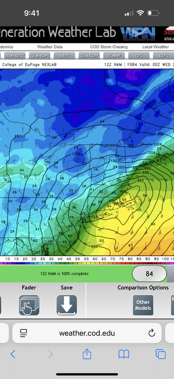
Thats crappy even here.. but its the 84hr NAM -
@Interstatementioned 12/8/13. That was the second-earliest December snow in my years here, at 8”. That winter turned out ok too.
-
First Winter Storm to kickoff 2025-26 Winter season
bristolri_wx replied to Baroclinic Zone's topic in New England
God NAMMIT! -

First Winter Storm to kickoff 2025-26 Winter season
CoastalWx replied to Baroclinic Zone's topic in New England
-

E PA/NJ/DE Autumn 2025 Obs/Discussion
Hurricane Agnes replied to PhiEaglesfan712's topic in Philadelphia Region
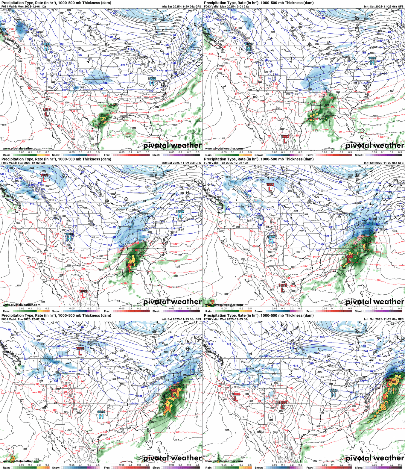
I heard some roaring and it wasn't the wind... it was this forum kicking into gear as something trackable emerges! Of course a concern would be the SSTs along the coast. The 6z GFS verbatim wants to do a Miller A type thing, out of the Gulf and up the coast. As an OBS, my low this morning was 30 and it's currently 34 with dp 23, so cold dry air out there (something that would have to moisten up if any rain has a chance here Sunday). -
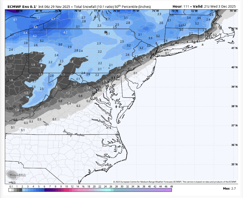
That might be more than some of us get altogether
-
Looks like some ice tonight. Ashe-Alleghany NC-Watauga-Tazewell-Smyth-Bland-Giles-Wythe- Pulaski-Montgomery-Grayson-Carroll-Floyd-Craig-Alleghany VA-Bath- Roanoke-Botetourt-Rockbridge-Patrick-Franklin-Bedford-Amherst- Mercer-Summers-Monroe-Eastern Greenbrier-Western Greenbrier- Including the cities of Roanoke, Boone, Tazewell, Pulaski, Buena Vista, Amherst, White Sulphur Springs, Floyd, Quinwood, Rainelle, Troutdale, Pearisburg, Wytheville, Galax, Bedford, Salem, Hinton, Fincastle, Lexington, Clifton Forge, Stuart, Hix, Marion, Volney, Alderson, Bluefield, Independence, Flat Top, Rocky Mount, Union, Duo, West Jefferson, Hot Springs, Sparta, Whitetop, Covington, Lewisburg, Bland, New Castle, Blacksburg, and Radford 300 AM EST Sat Nov 29 2025 ...WINTER WEATHER ADVISORY IN EFFECT FROM 2 AM TO NOON EST SUNDAY... * WHAT...Freezing rain expected. Total ice accumulations of less than a tenth of an inch. * WHERE...Portions of northwest North Carolina, central, south central, southwest, and west central Virginia, and southeast West Virginia. * WHEN...From 2 AM to noon EST Sunday.
-
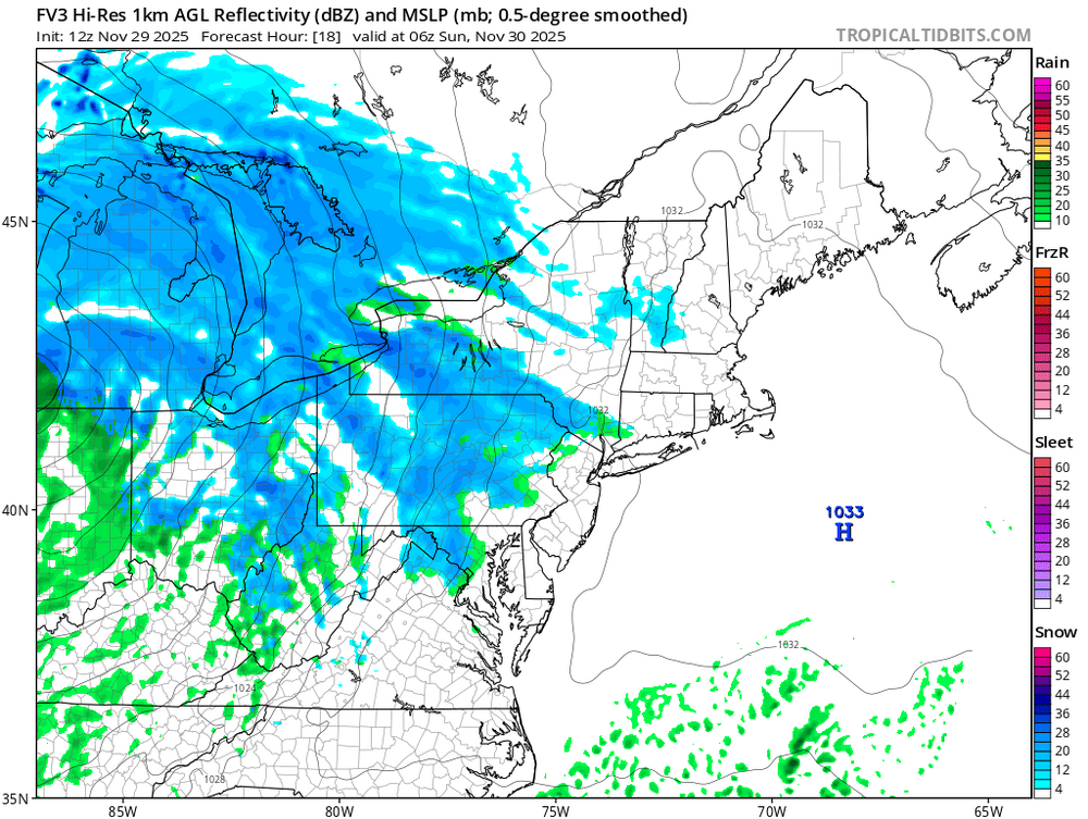
Just going to include tonights little thump in this thread. FV3 and 3k both have it. RGEM not so much.
-
My first indicators of how future modeling will go, the NAM and RGEM. RGEM tends to be a warmer model. NAM tends to be quite amped at times. Still, I need to know whether NYC is still in the game for first measurable of the season. If the NAM 60-84 have NYC in some sort of snow, especially early Tues...thats good news, not necessarily correct. If the RGEM is likewise earlier and colder ptypes=qood news. You'll be more to date than I but that's how I read Global tendencies (OFF the mesoscale models - NAM supposed to go away in 2026). I do think the GFS is and has been too amped but this will be a significant short wave cutting east across NJ 00z/Wed so I foresee intensification as it rips negatively out into the north Atlantic. Tremendous RRQ lift from the St Law Valley 250MB 180 speed max.
-

November 2025 general discussions and probable topic derailings ...
dendrite replied to Typhoon Tip's topic in New England
-
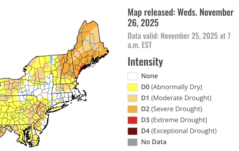
Temp dropped to 29 early yesterday evening, then rose to 37 by midnight before dropping to our low of 28. Nice hard freeze as temp stayed below freezing for a good solid 6 hours. I really hate living so close to the water this time of the year.
-
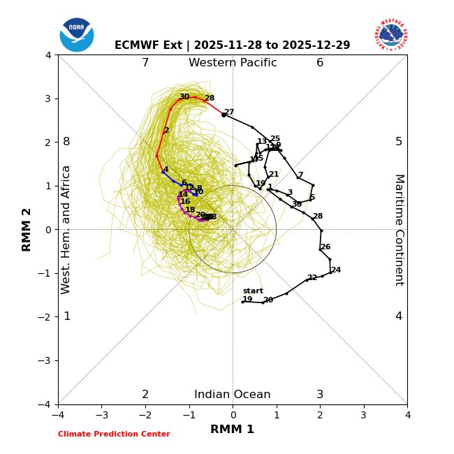
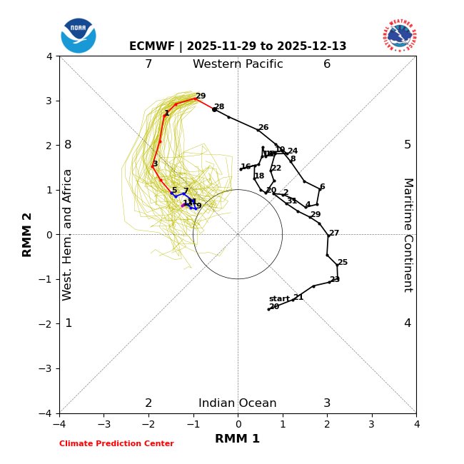
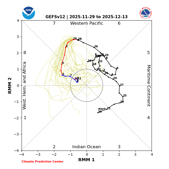
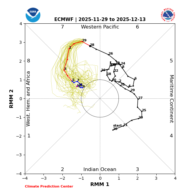
MJO from today’s 2 week runs: both now have 11+ day long phase 8s, longest since Feb 2010 and longest Dec since 1975. Lots of potential in 1st half of Dec and beyond! GEFS is all in 8 12/3-13 vs yesterday’s 7 for same period: EPS is same as yesterday:
-
@donsutherland1 Out of curiosity, do you have any temp/precip composites for +EPO, +PNA, -AO, -NAO Decembers?
-
Paul Roundy @PaulRoundy1 The west Pacific warm pool is changing shape. Eventually it will allow for more convection near the Dateline, which can favor western N. America ridges. Paul Roundy @PaulRoundy1 38m If the western ridge is far enough west, it can favor a central N. American trough and eastern ridge. 1997 Feb-Mar had eastern US ridging in spite of central Pacific convection.
-
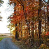
A mid winter look in late November. Rare.
-
Lets hope that is a harbinger of the winter that is coming...
-
thread the needle as always. just very hard for the city to good snows now in general, regardless of if its dec, jan or feb.
-
-
Nov 28-30th Post Turkey Day Winter Storm
King James replied to Chicago Storm's topic in Lakes/Ohio Valley
Nice little storm. Good flakes on a Saturday morning after a holiday. Can’t ask for more -
-

Central PA Fall Discussions and Obs
mahantango#1 replied to ChescoWx's topic in Upstate New York/Pennsylvania
-
Yeah that's not happening, esp from the Fall line east. If I am up early enough maybe I will see a few mangled flakes before it turns to rain.







.png.ca6d6a1708312fcc53c4c4fe4100cb2f.png)

