All Activity
- Past hour
-
Per Roundy the warm pool near the MC continues to move east. One would think, especially if this continues, the default forcing may shift east as well.
-

Winter 2025-26 Medium/Long Range Discussion
cyclone77 replied to michsnowfreak's topic in Lakes/Ohio Valley
Lock it in. -
Yep, and just 3 runs ago was an epic winter storm.
-
It really wouldn’t take much to amp this up a little more…just need that SPV to drop in behind the speeding shortwave a little earlier/deeper.
-
And the cold is even Westivus for Festivus
-
Expecting some wind driven sprinkles here, followed by a few passing snow showers late tonight. Biggest story here will be 40+mph winds later tonight/tomorrow.
-

Winter 2025-26 Medium/Long Range Discussion
migratingwx replied to michsnowfreak's topic in Lakes/Ohio Valley
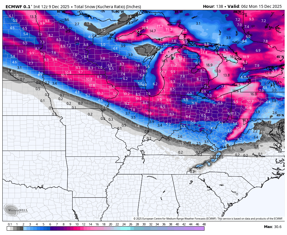
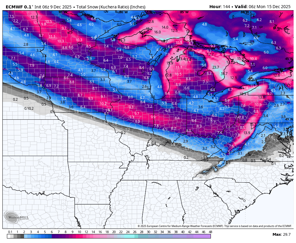
Euro has shifted north from earlier runs for the Friday and Saturday systems. 12z vs 6z bottom 2 maps below


-
thank you!
-

The Monday wintry event potential (12/8/25)
strongwxnc replied to GaWx's topic in Southeastern States
The one with the house is so good. -

December 2025 regional war/obs/disco thread
Kitz Craver replied to Torch Tiger's topic in New England
Lol, I thought that was a deep terminator reference I wasn’t aware of -
We're 2" on Pivotal fwiw. Charlottesville still gets more than that. And you know they will actual get it while ours is iffy. Lol
-
Both years still showing up and idea I shared earlier in this thread if a 30-45 day pronounced cold run is still in play and underway. By the end of Dec (29-31) we will be at 30 days and will see if it extends further Don’t worry about model confusions, Christmas 20-27 will not be a torch
-
Yeah I posted that earlier. Was waiting to see if someone got my Robocop reference lol. Euro op was good for the cranberry bogs. At least it didn’t vanish.
-
-
This will be verification
-
op skynet looks good.
-

December 2025 regional war/obs/disco thread
40/70 Benchmark replied to Torch Tiger's topic in New England
How many ways can we find to avoid plowable snow in Boston? -

December 2025 regional war/obs/disco thread
weatherwiz replied to Torch Tiger's topic in New England
Looks fine to me...even around MA Pike -
December 2025 regional war/obs/disco thread
40/70 Benchmark replied to Torch Tiger's topic in New England
It wasn't a full reversal. -
I’d be fine with 3” of snow this weekend between the two systems. Just give us something.

-

Central PA Winter 25/26 Discussion and Obs
MAG5035 replied to MAG5035's topic in Upstate New York/Pennsylvania
The EPO plays pretty big factor in this as well, surprised he doesn’t mention it. After it takes a major dip the rest of this week behind tomorrow’s system all ensembles have it reversing to a pretty positive regime by later next week getting into Christmas week, setting up the period where we may moderate. Ensembles do show the very persistent -WPO regime in a pretty classic representation of such with major ridging centered on the Bering Sea throughout. This helps establish cold continental source region of the airmass into Canada. In combo with a -EPO that’s a good recipe for dumping cold over most of the eastern 2/3s of the lower 48.. which is what we see coming up the next 6-10 days. EPO in its negative phase promotes more ridging into the west coast of the US up into Canada and Alaska, and a stronger jet/lower heights into the western US in its positive phase. It has high correlation to anomolous temps cold (negative) and warm (positive) in our neck of the woods. A split in the teleconnections with a -WPO/+EPO makes for a bit less certainty. If teleconnection forecasts are right with the switch to a solid +EPO we’ll have a good bit of Pac modified air injected into the pattern but also still plenty of cold in Canada. Another factor to pair with +EPO here is AO/NAO also being forecast to be positive, which implies lower heights nearer to the pole and a contraction of cold air press into the CONUS. So there is a pretty solid case for moderation here because while there is plenty of cold available in Canada this combo probably sets up a high zonal flow across the US. I don’t necessarily see us torching but I see it more as a detriment in terms of storm track (low track running north of PA) since we have had a northern branch dominated regime and next to no southern stream influence so far in the early going. It might still roughly reflect a P8 MJO regime in the temp department, but that alone doesn’t put the white gold on the ground. So we’ll see how that evolves, in the meantime we will continue to be cold for the next week or so with the opportunity for at least another light snow event or two, with the Saturday night/Sun wave showing the best promise. There won’t be much moisture associated but that particular wave will have pretty cold air set in place, and a couple of tenths of QPF could easily turn into a 2-5” type event. -

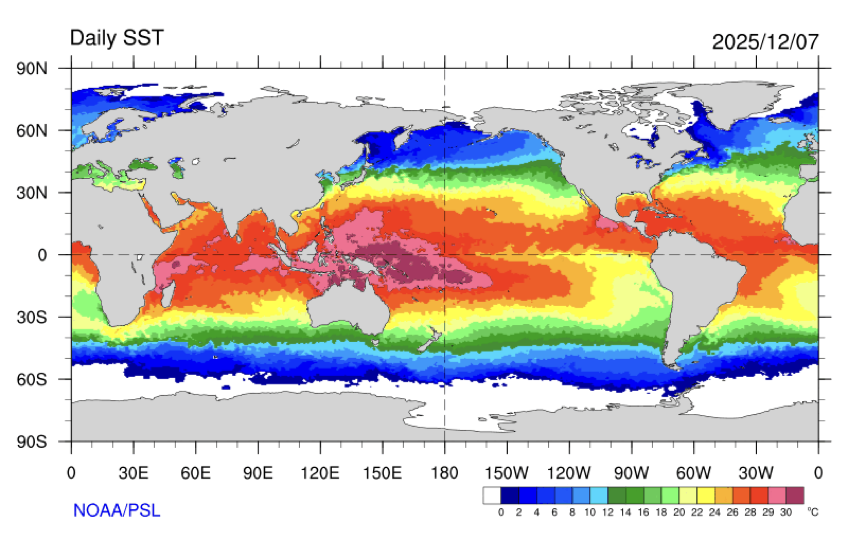
2025-2026 ENSO
TheClimateChanger replied to 40/70 Benchmark's topic in Weather Forecasting and Discussion
-
His field vision is horrible this year. He can't check off the primary receiver and hit someone who is usually wide open and camping out right in front of him in the middle of the field...usually Goedert.
-
Actually a nice look for SE MA.
-
12/5 3.5” 12/8 5.5” Total: 9” Powhatan