All Activity
- Past hour
-

First Winter Storm to kickoff 2025-26 Winter season
Baroclinic Zone replied to Baroclinic Zone's topic in New England
-
The EPS and and GEPS caved to the GEFS on the +EPO/Alaskan vortex by the 2nd week of December, but they go +PNA/-NAO so it keeps the east under a trough
-

First Winter Storm to kickoff 2025-26 Winter season
WinterWolf replied to Baroclinic Zone's topic in New England
I tried to tell him…but he’s got a paste obsession. -

Nov 28-30th Post Turkey Day Winter Storm
cyclone77 replied to Chicago Storm's topic in Lakes/Ohio Valley
No doubt. MLI was up to 4.9" already as of 6am, so they will blow by the seasonal total by early to mid afternoon. -

First Winter Storm to kickoff 2025-26 Winter season
ORH_wxman replied to Baroclinic Zone's topic in New England
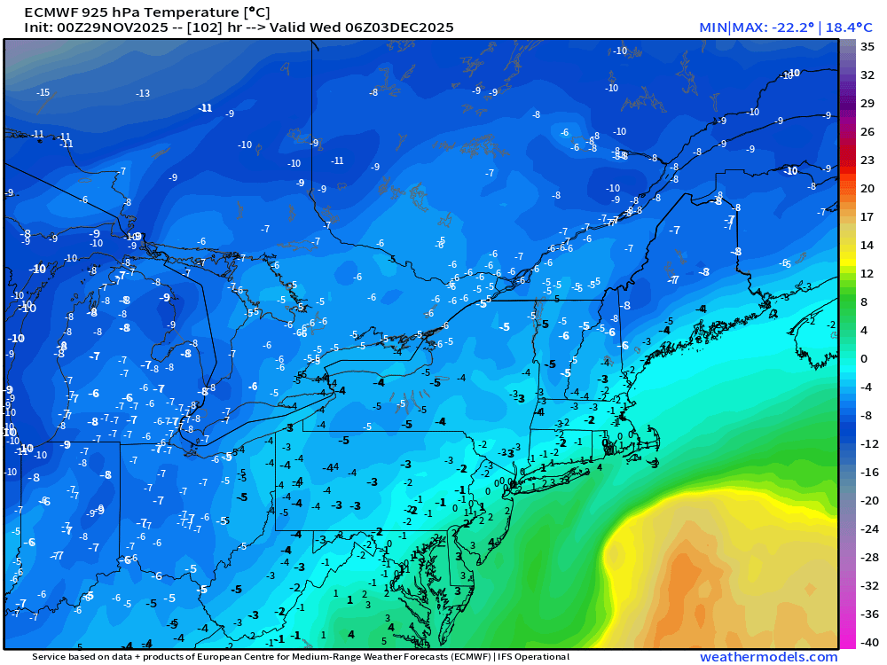
Here’s the meat of the storm with the real rates on the 00z euro….paste zone is prob more like SE MA to interior SE CT on that look…interior MA to interior N CT is prob a degree or two cold enough to not be too pasty -
Low of 27°
-

First Winter Storm to kickoff 2025-26 Winter season
ORH_wxman replied to Baroclinic Zone's topic in New England
The thing is, if you amped the euro solution from 00z just a bit more, then you and me would prob see a lot more paste, Kevin since we’d be closer to 0C from like 900mb to surface. But if it’s more like -2C then it’s gonna be more powdery. -
-

First Winter Storm to kickoff 2025-26 Winter season
ORH_wxman replied to Baroclinic Zone's topic in New England
No it wound be like 28-30F for you. Not really pasty. Maybe for a brief time early on. -
Thanks for this. The only good snowfall winter on the list for CPK is 64/65.
-
When does the Soul season start? Asking for a friend.
-
Finally on the board for the season with a whopping 0.1"
-
Winter 2025-26 Medium/Long Range Discussion
A-L-E-K replied to michsnowfreak's topic in Lakes/Ohio Valley
More early than mid week but trends are favorable here -
Central PA Fall Discussions and Obs
mitchnick replied to ChescoWx's topic in Upstate New York/Pennsylvania
I'm having some serious doubts for mby. I need a cooling trend to start if not today, definitely by tomorrow. -
Winter of ‘24-25 soon to be a distant memory
-

First Winter Storm to kickoff 2025-26 Winter season
TauntonBlizzard2013 replied to Baroclinic Zone's topic in New England
Hey, my expectations couldn’t be lower lol. -

Nov 28-30th Post Turkey Day Winter Storm
OrdIowPitMsp replied to Chicago Storm's topic in Lakes/Ohio Valley
Getting some light snow this morning, the roads are snow covered. Wasn’t really expecting anything until noon, still think 2-4” here -
Records: Highs: EWR: 70 (1990) NYC: 69 (1990) LGA: 69 (1990) JFK: 64 (2017) Low: EWR: 15 (1955) NYC: 14 (1875) LGA: 17 (1955) JFK: 25 (1989) Historical: 1835: -11 °F below zero at Ft. Snelling, MN. (Ref. AccWeather Weather History) 1896 - The mercury plunged to 51 degrees below zero at Havre, MT. It marked the culmination of a two week long cold wave caused by a stagnate high pressure area similar to those over Siberia during the winter. During the month of November temperatures across Montana and the Dakotas averaged 15 to 25 degrees below normal. (David Ludlum) 1898: Boston, Massachusetts on the 27th and 29th had 12 inches of snow the greatest 24 hour total for the month of November. (Ref. NOAA Boston Weather Events) (Ref. Wilson Wx. Additional Info.) 1921: The Worcester, MA area was especially hit by a major three day ice storm that affected central New England. Trees and wires were downed over a wide area. Millions of dollars in damage resulted. (Ref. AccWeather Weather History) 1930: Cold wave 14° at 2416 M St. N.W. in Washington, DC with 15° recorded on the 28th - (Washington Weather Records - KDCA) The low temperature of 10 °F is the lowest ever recorded in Richmond, VA in November and also occurred on November 16th 1933.(Ref. Richmond Weather Records KRIC ) 1963: Coastal storm with a 29.04 barometer and 1.55 inches of rain at KDCA and NW winds to 33 mph. (Ref. Washington Weather Records - KDCA) 1966: High winds struck the Chicago, IL area producing extensive damage. Winds gusted to 55 mph along the Lake Front and 48 mph at Midway Airport. The Lake Front was the hardest hit with waves up to 13 feet high. Low lying areas were inundated and property damage was extensive. A newly constructed home along the Lake Front was demolished at Long Beach, IN. (Ref. Wilson Wx. History) 1969 - Dense fog along the Jersey Turnpike resulted in a chain reaction of vehicle collisions during the morning rush hour. A propane truck jacknifed and was struck by a trailor truck, and other vehicles piled into the fiery mass. (David Ludlum) 1975 - Red River was buried under 34 inches of snow in 24 hours, establishing a record for the state of New Mexico. (The Weather Channel) This was also a day for record temperatures. Some record lows were set from the Rockies to the West Coast. Fresno, CA dipped to 26° establishing their coldest temperature on record for November. Other daily record lows included: Butte, MT: -22°, Cut Bank, MT: -21°, Lewistown, MT: -11°, Casper, WY: -10°, Billings, MT: -5°, Reno, NV: 5°, Grand Junction, CO: 5°, Olympia, WA: 14°, Idyllwild, CA: 16°, Palomar Mountain, CA: 17°, Stockton, CA: 26°, Los Angeles (LAX), CA: 41° and Downtown Los Angeles, CA: 41°-Tied. (Ref. Wilson Wx. History) 1985 - The temperature at Bismarck, ND, plunged to 30 degrees below zero to establish their record low for the month of November. The high that day was 4 degrees below zero. (The Weather Channel) In contrast, an upper level ridge brought record highs to parts of the southeast including: Tampa, FL: 85°-Tied, Wilmington, NC: 83°, Charleston, SC: 82° and Savannah, GA: 82°-Tied. (Ref. Wilson Wx. History) 1987 - Snow blanketed the Upper Mississippi Valley, with heavy snow reported near Lake Superior. Up to ten inches of snow was reported in Douglas County and Bayfield County of Wisconsin. Brule WI received nine inches of snow. Heavy rain soaked the Middle Atlantic Coast States, while gale force winds lashed the coastline. Flooding was reported in Maryland and Virginia. (Storm Data) (The National Weather Summary) 1988 - Nine inches of snow at Alta UT brought their total for the month to 164 inches, surpassing their previous November record of 144 inches. Snowbird UT, also in the Little Cottonwood Valley, surpassed their November record of 118 inches of snow. (The National Weather Summary) (Storm Data) 1989 - Strong Santa Ana winds diminished over southern California, but record cold was reported in some of the California valleys, with readings of 27 degrees at Redding and 31 degrees at Bakersfield. Gale force winds, gusting to 44 mph at Milwuakee WI, produced snow squalls in the Great Lakes Region. Sault Ste Marie MI finished the month of November with a record 46.8 inches of snow. (The National Weather Summary) (Storm Data) 1991:A tornado struck southeast Springfield, Missouri, causing F4 damage. Shortly after touchdown, the tornado reached F3 intensity, approximately 3 miles north of the town of Nixa. While crossing Highway 65, the tornado picked up a truck and dropped it onto a frontage road, killing one passenger and injuring ten others. The tornado intensified to F4 strength as it moved through the Woodbridge and Natural Bridge Estates subdivisions where 15 homes were destroyed. Altogether, two people were killed and 64 others were injured. 1998: A strong upper level ridge and surface high pressure brought record warm temperatures ahead of a cold front from the Midwest & southern Plains to the Mid-Atlantic States. The morning low in Rochester, MN of 54° was actually higher than the previous record high for the date. The temperature reached a record high of 62°. (Ref. AccWeather Weather History) 2006: An upper level trough across the Rockies brought record low temperatures for the date including: West Yellowstone, MT: -26, White Sulfur Springs, MT: -22, Bozeman, MT: -18, Boulder, MT: -18, Ennis, MT: -18, Dillon, MT: -16, Townsend, MT: -14, Stanford, MT: -13, Livingston, MT: -12 and Virginia City, MT: -11. (Ref. Wilson Wx. History) 2009: Western Texas Panhandle: Snow falls in the western Texas Panhandle with Nazareth covered by 4.0 inches and 3.0 inches just southwest of Amarillo, Texas. (Ref. WxDoctor)
-

First Winter Storm to kickoff 2025-26 Winter season
Damage In Tolland replied to Baroclinic Zone's topic in New England
Just going what Scooter and Scoots Jr. said yesterday -

First Winter Storm to kickoff 2025-26 Winter season
WinterWolf replied to Baroclinic Zone's topic in New England
Not paste if that Euro deal played out..but it was just another solution anyway, so it’s a moot point. -
Nov 28-30th Post Turkey Day Winter Storm
Radtechwxman replied to Chicago Storm's topic in Lakes/Ohio Valley
Yeah that dry pocket worries me a bit. My snow im in is on eastern fringes of that. Hoping it doesn't creep east and hoping it fills in more. Flake size has been pretty small so far. -
19 here also
-
anotherman started following 12/2 Cold Rain and High Elevation Snow
-

First Winter Storm to kickoff 2025-26 Winter season
moneypitmike replied to Baroclinic Zone's topic in New England
Then we would need to lead productive lives. -

First Winter Storm to kickoff 2025-26 Winter season
WinterWolf replied to Baroclinic Zone's topic in New England
Yes…this is what I meant. It would already be predominantly locked in now. Ahh that’s when it was something special:, -

First Winter Storm to kickoff 2025-26 Winter season
Damage In Tolland replied to Baroclinic Zone's topic in New England
I think it would be


