All Activity
- Past hour
-
0.49” 7am-7pm 5/23. 3.53” for event since 5/20.
-
Just a guess but I'd say you make up for it.
-
Stuck in the wedge here in Lake Norman. Misting rain off and on, fog, and 60 degrees on Memorial Day weekend. Was hoping for some good thunderstorms, but the atmosphere is too stable.
-
There’s barely any restriction though, it’s all voluntary.
-
Record cold high temperature today in the Triad
-
I think that was the cell i was watching on my radar yesterday
- Yesterday
-
0.50" 50°
-

Central PA Spring 2026 Discussion/Obs Thread
Itstrainingtime replied to Voyager's topic in Upstate New York/Pennsylvania
Temp down to 49. 0.91" of rain today -
This has a jog to the memory of the "big" snow we had here in NC this past Feb and the raleigh area was the snow hole. Hopefully that blob of rain and storms over I 95 around KFLO and points N & W will make it here. Otherwise today will be a dry day with only .07" today so far
-
Not complaining, wondering if the rain totals will be lower side or do we make up for it tonight into tomorrow?
-
Amazing how long it took to get into NE CT. Force field indeed. The radar has been fascinating to watch today. Can't imagine the melts there would be in here if this was snow.
-
Don’t speak that into existence
-
Almost an hour since it started and driveway is barely wet; glad this isn’t snow!
-
0.51” so far in Syosset.
-

Central PA Spring 2026 Discussion/Obs Thread
canderson replied to Voyager's topic in Upstate New York/Pennsylvania
Flying back home tonight from Vancouver. Looks like a rainy week was had! -

2026-2027 Strong/Super El Nino
Stormchaserchuck1 replied to Stormchaserchuck1's topic in Weather Forecasting and Discussion
This is what 1997 was like.. June is finally getting close with a Canadian ridge now showing up on medium-range models Edit: You could say May is pretty close -
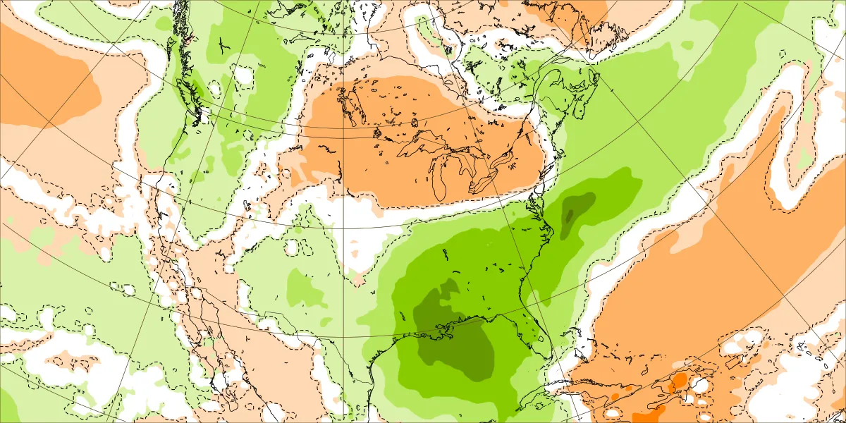
Euro Weeklies are still quite wet in the SE next week (5/25-31) as this represents 2-3” for many:

-
52 for the max today, not bad for March
-

2026-2027 Strong/Super El Nino
snowman19 replied to Stormchaserchuck1's topic in Weather Forecasting and Discussion
Yea, we normally see a raging STJ during a La Niña. Looks very Niña like!! Lol -

Winter 25-26 (All Snowfall Maps & Season Total)
ORH_wxman replied to The 4 Seasons's topic in New England
Upper outer cape will frequently do a little better than a place like MVY on a seasonal level. That extra latitude makes up for being out there. They usually get a few extra inches per season from OES too. The outer cape can get clipped on a NNW OES setup while everyone else misses. -
I HATE Houston. They got all our rain today. That radically altered the forecast for Austin, now progged for sunny and hot right into Wednesday. The southeastward repositioning of todays storm radically changed Austin's weather. Now its going to be a picture perfect wall to wall sunshine, Texas-style Memorial Day Weekend! Mid 80s to mid 90s temps, dews in the low 70s with an occasional passing cloud. Sure we need to dry out BUT we got millions and millions of people moving here as Austin fast becomes the North American Hub for tech. Man we gotta get those aquifers filled.
-
They do not open the third lane east bound when there is rain or stronger winds, so it's just horrendous timing. They do it to prevent incidents of cars/trucks blowing into the head-on traffic, or hydroplaning into head-on. They also canceled the Bay Bridge Run back in November for the same exact reason. I don't ever foresee them changing that rule either.
-

Central PA Spring 2026 Discussion/Obs Thread
Blizzard of 93 replied to Voyager's topic in Upstate New York/Pennsylvania
.87 of rain in Marysville so far today. -
2026-2027 Strong/Super El Nino
Stormchaserchuck1 replied to Stormchaserchuck1's topic in Weather Forecasting and Discussion
They are just expressing what they think should happen. We continue to be in this mid latitude Hadley Cell expansion phase, despite El Nino. -
Heavy rain now Temp 49