All Activity
- Past hour
-
It looked better 20 minutes ago. Seems to be drying out now.
-
radar looks pretty robust out of the SW. do you think we have a chance?
-
Welcome! When we get coastals, Fallston does really well. I think we had close to 36" in Jan 2016. I also measured 125" in my backyard in the Winter of 02-03.
-
Prior the turkey day it looks to be a battle between AI/GFS/Euro VS the ensembles In a real mans world you'd stick with the ensembles this far out.Guess we'll see who caves in the upcoming days.But i thought my self there would be a trough in the East before turkey day
-
Welcome neighbor! We do much better for snow here, every mile makes a big difference. You're also kind of in a nice thunderstorm spot. Baltimore to just south of me is a zone that gets hit whenever we are risk.
-

2025-2026 ENSO
Stormchaserchuck1 replied to 40/70 Benchmark's topic in Weather Forecasting and Discussion
Usually ENSO related December isn't a big month for PNA Correlation really gets higher in Jan-Feb.. You know how we're following it so far.. -
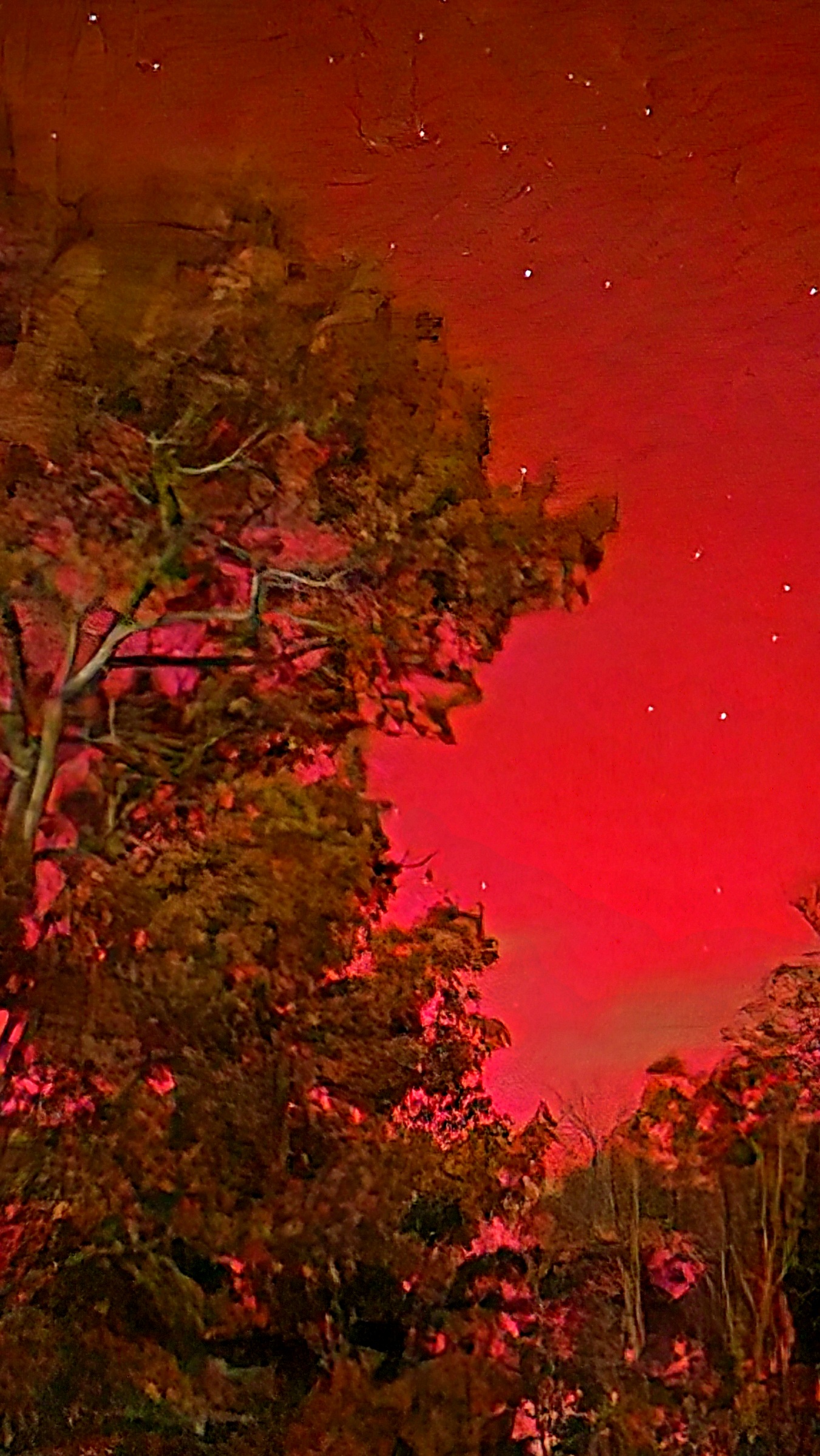
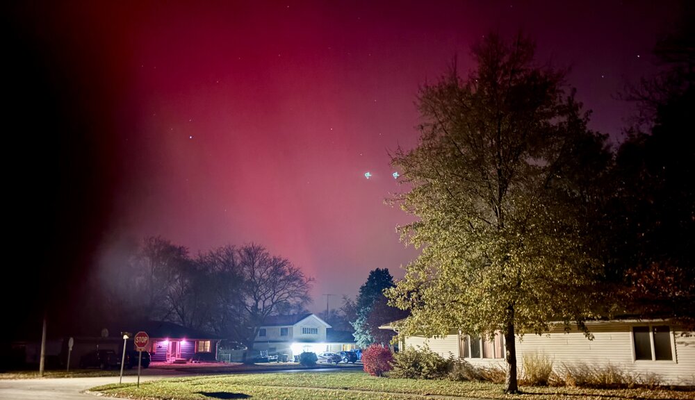
It looks like an Oblivion Gate opened in Bob Chill’s backyard (IYKYK ) Edit: this was referencing the super red pic further up
-
A Carrington event right over Kevin.
-
The entire valley is full overcast.
-
Third event in the last 18 months down here. Kinda pedestrian. Last fall was better hahaha

-
-
Yea, this is a pretty common occurrence, so next time. Fire up the tractor, bitch!
-
Yes. The 12z EPS started to show RNA the tail end of this month into December. I believe the -PNA flip is definitely coming. I also don’t doubt the -AO/-NAO/-EPO/-WPO
-

2025-2026 ENSO
PhiEaglesfan712 replied to 40/70 Benchmark's topic in Weather Forecasting and Discussion
February 2006 wasn't all that bad. At least we got a return to cold, and a snowstorm on the 11th-12th. I'd gladly sign up for that after the last 3 or 4 winters. But please, no repeat of 1989-90, when spring pretty much began in January. -
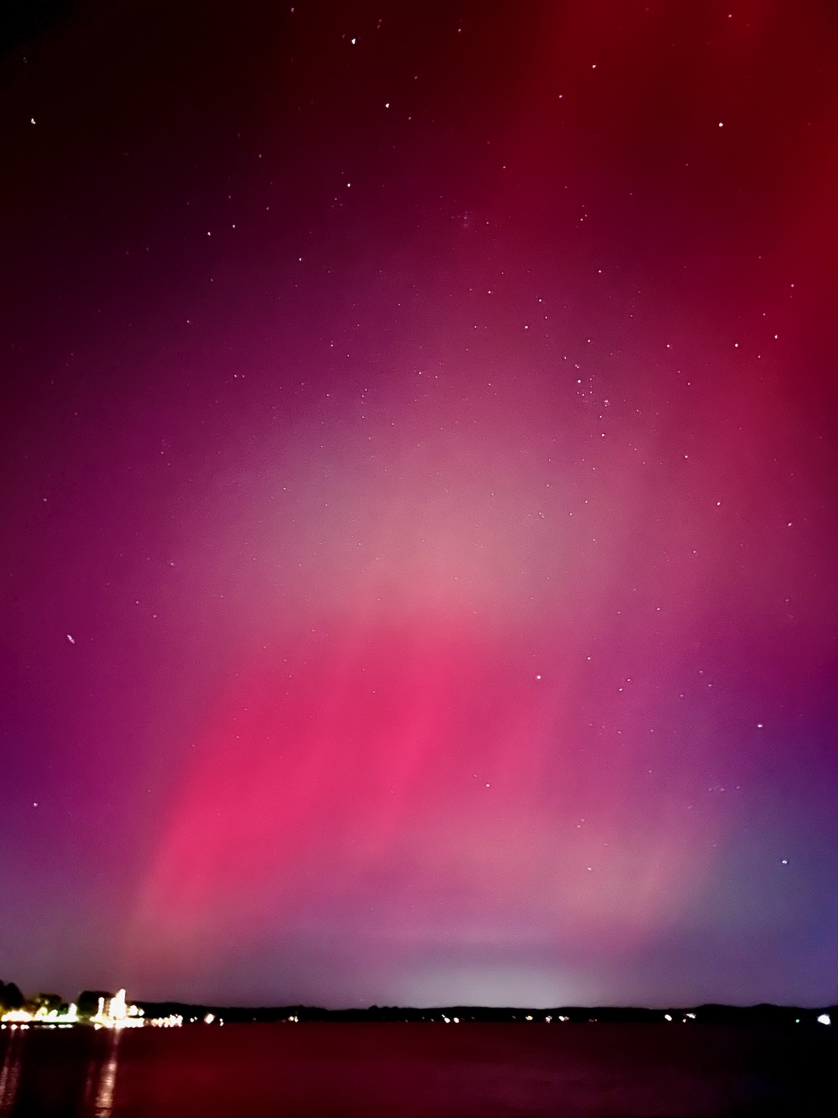
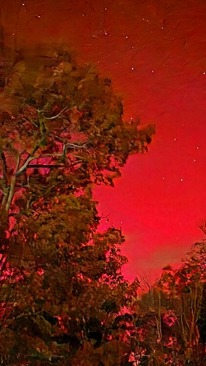
Took a quick look 10 mins ago and was easy to see with naked eyes. 4 second exposure on this pic so obviously enhanced lol but I could see the red thru the branches with my eyes as well. Thought about running down to the lake for a big horizon pic but man it's windy and cold. Maybe tomorrow.
-
That and the peak of the next one will hit during the day
-
Hopefully the grid goes down tomorrow
-
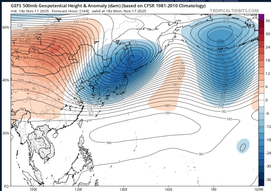
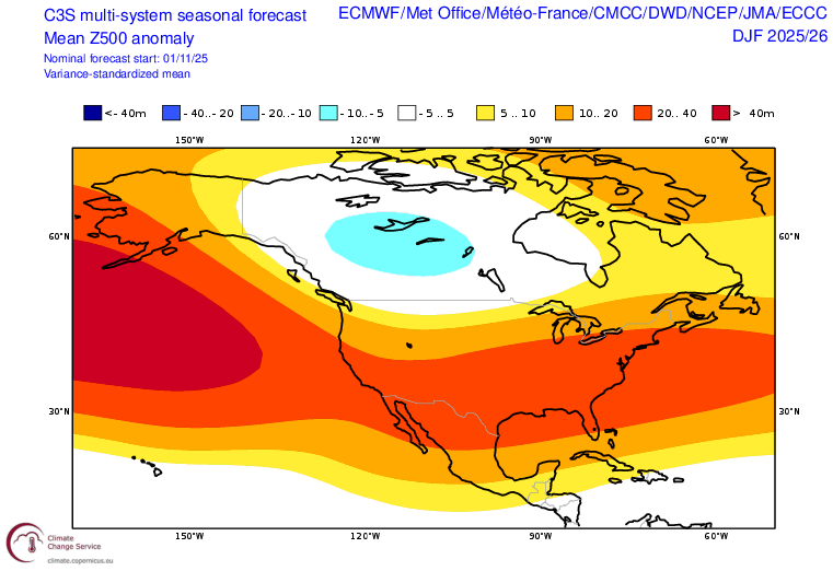
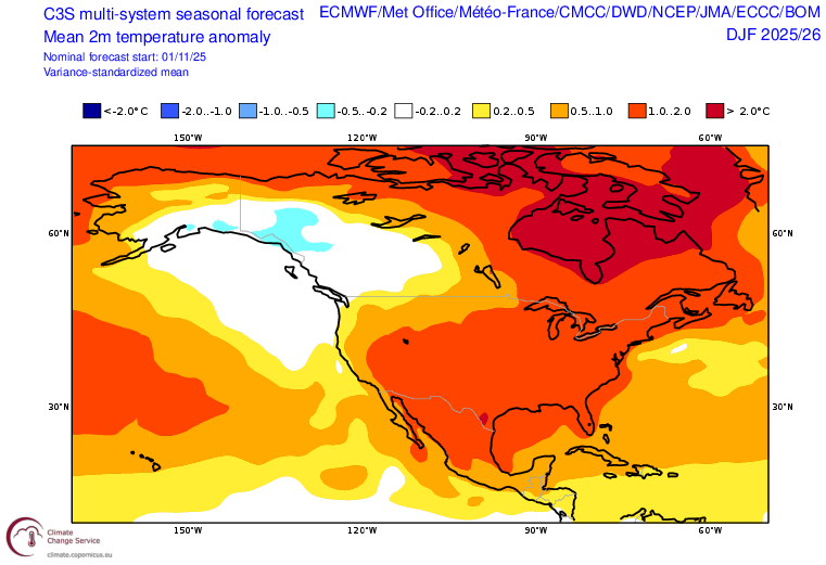
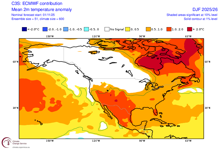
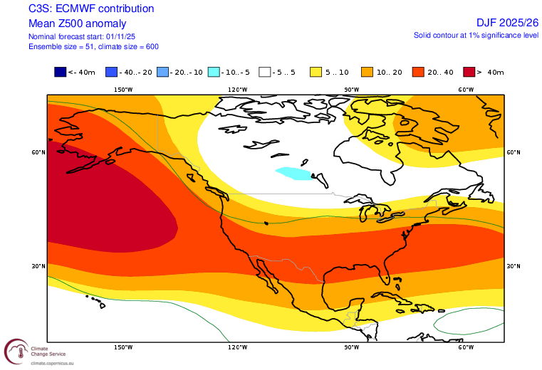
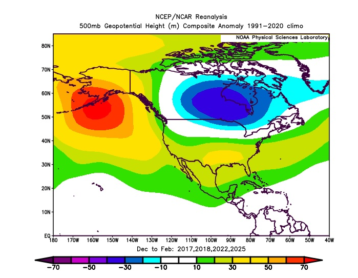
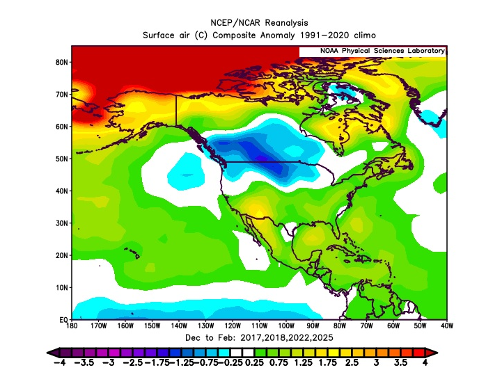
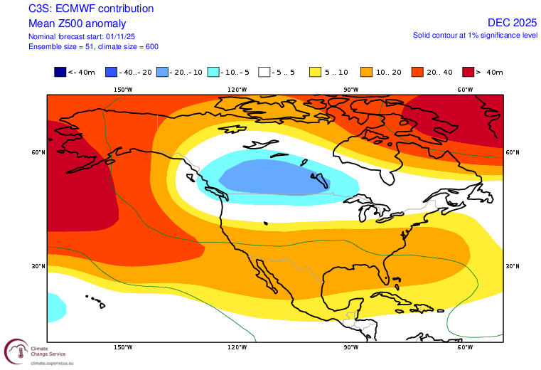
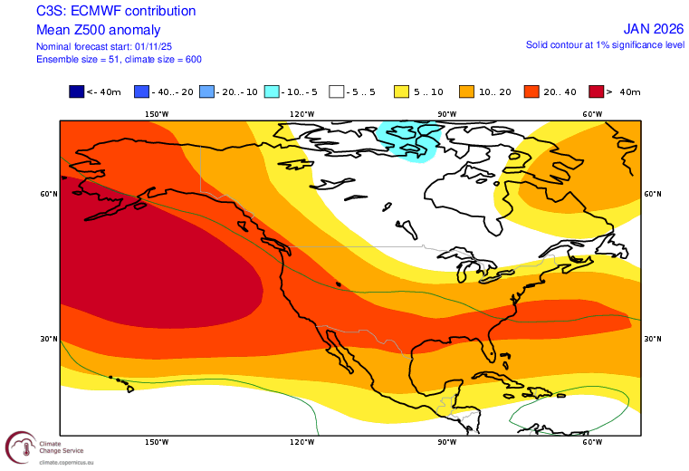
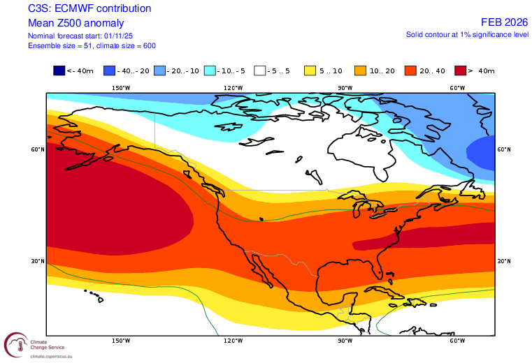
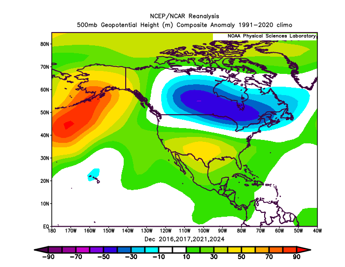
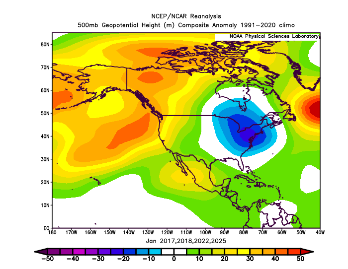
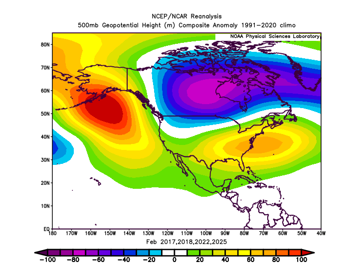
A classic La Niña winter appears to be on the way. There will likely be some interesting developments, along the way, particularly if a sudden stratospheric warming event materializes in late November or early December. Then, the potential would exist for a cold end to December and possibly first half of January, if the polar vortex is displaced. Based on ENSO and the teleconnections, there is a signal for the coldest month relative to normal to be January in the Gulf Coast and Southeast. Perhaps the Arctic outbreak of November 10-11 that saw the coldest anomalies affect the Southeast offers a hint of how things might unfold in January. The C3S multi-model system appears to be quite aggressive with above normal temperatures. Last winter, there were some indications that it was too aggressive with the warmth, but I deferred to the guidance. That proved to be a bad mistake leading to an overly warm idea. This time, I am giving more weight to the analog cases for insight. The ECMWF seasonal forecast appears to be a better fit with the final cases I selected based on ENSO and the teleconnections. My selected comparison cases for Winter 2025-2026 are Winters 2016-2017, 2017-2018, 2021-2022, and 2024-2025. C3S Seasonal Forecasts: ECMWF: Analog Cases: ECMWF: December-February 500 mb Progression: Analog Cases: December-February 500 mb Progression: Select Snowfall Estimates: Albany: 45"-60" Baltimore: 10"-15" Binghamton: 80"-90" Boston: 35"-45" Buffalo: 85"-95" Burlington: 75"-85" Caribou: 110"-125" Chicago: 30"-40" Detroit: 40"-50" New York City: 15"-25" Newark: 15"-25" Philadelphia: 10"-20" St. Louis: 10"-15" Toronto: 100 cm - 125 cm Washington, DC: 8"-12"
-
High of 49 and currently 38. Insanely cold early November day with full sun
-
There’s some reflectivities racing across virginia. Maybe a few flakes will make it down…
-
2025-2026 ENSO
Stormchaserchuck1 replied to 40/70 Benchmark's topic in Weather Forecasting and Discussion
I am a little worried about Jan and Feb in the 1989-90 and 2005-06 analogs. I do think there will be more -AO in Jan/Feb so we'll see how that goes. -

E PA/NJ/DE Autumn 2025 Obs/Discussion
LVblizzard replied to PhiEaglesfan712's topic in Philadelphia Region
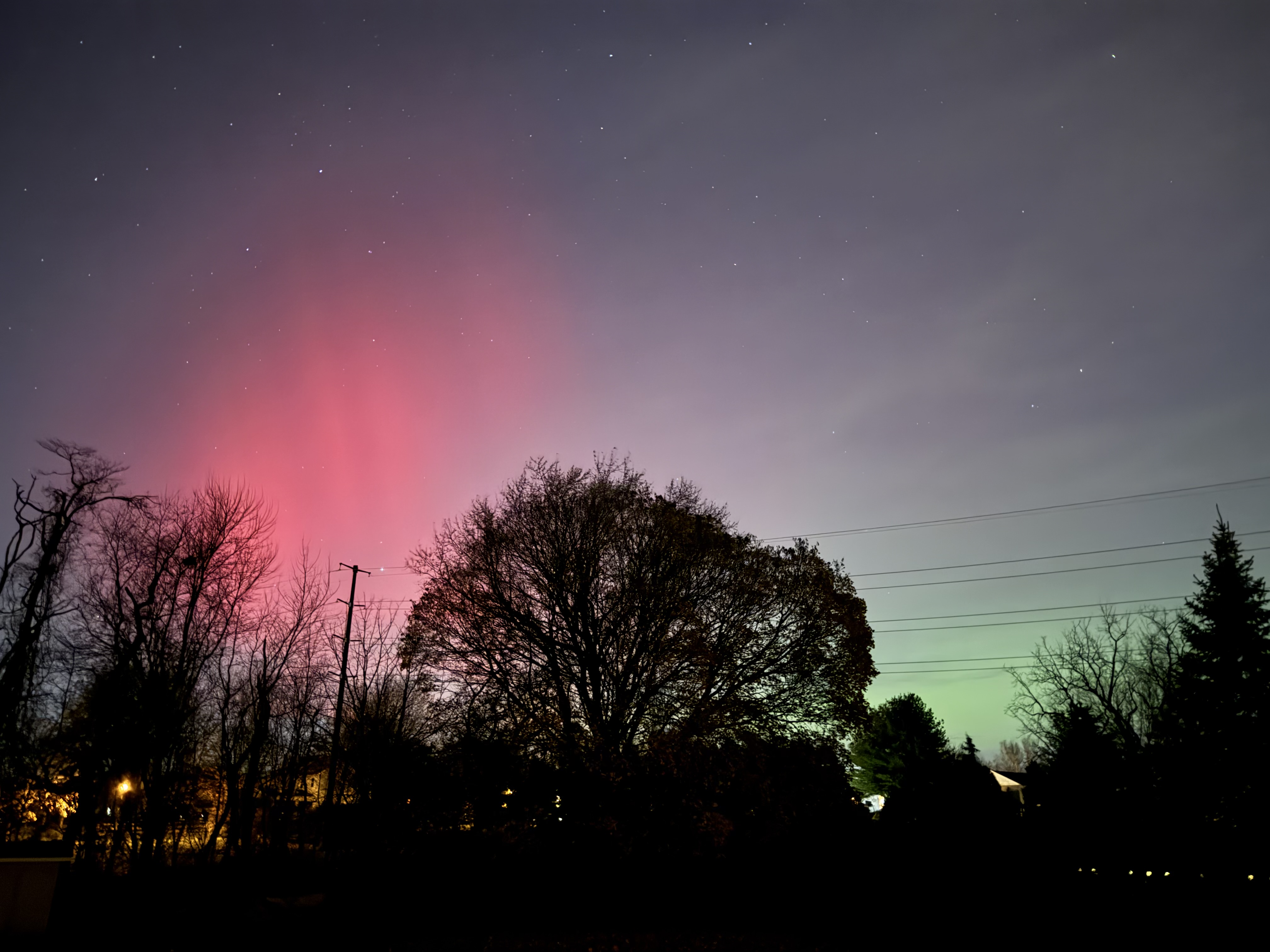
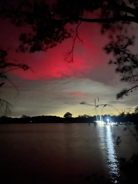
Vivid naked eye aurora visible 10 minutes ago in Allentown!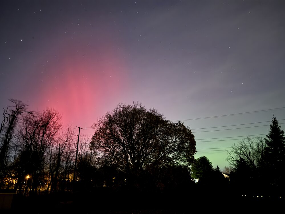
-
-
2025-2026 ENSO
Stormchaserchuck1 replied to 40/70 Benchmark's topic in Weather Forecasting and Discussion
You think? Long range models are showing more +PNA at the Day-15+ range. It's looking like a -WPO/-EPO wants to develop with a little +PNA under it. I don't see any signs of RNA on current long range models for late November, although I don't know if the Euro weeklies show that in Dec (It looks pretty neutral in the N. Pacific with the cold coming from west-based -NAO). -
More of a southerly trajectory to the winds and CAA aloft ended.


.thumb.png.4150b06c63a21f61052e47a612bf1818.png)