All Activity
- Past hour
-
A nice Friday on this being of those weeks of not much sun for the final week of November which will be followed by a crappy final weekend of the month.
- Today
-

Nov 28-30th Post Turkey Day Winter Storm
Chicago Storm replied to Chicago Storm's topic in Lakes/Ohio Valley
Already snowing here at home, with the ground dusted. -
23 here with 3 hours left. Teens are going to be close.
-

First Winter Storm to kickoff 2025-26 Winter season
40/70 Benchmark replied to Baroclinic Zone's topic in New England
I don't think it is..let's see what verifies. It's not zero chance, though....any time you get a weak PV the guard has to be...which is why I said slight chance of a KU between Dec 1 and 15, but I think the better window is late season. -

Nov 28-30th Post Turkey Day Winter Storm
Powerball replied to Chicago Storm's topic in Lakes/Ohio Valley
I remember watching it live. The best part about it? That was actually a massive forecast bust. In the run up to the game, only maybe 1-3" at best was expected befoe it transitioned to rain (of course, by the time they realized the forecast was going to be a bust, they were already too far into the game to postpone it). Best game ever... -

First Winter Storm to kickoff 2025-26 Winter season
WxWatcher007 replied to Baroclinic Zone's topic in New England
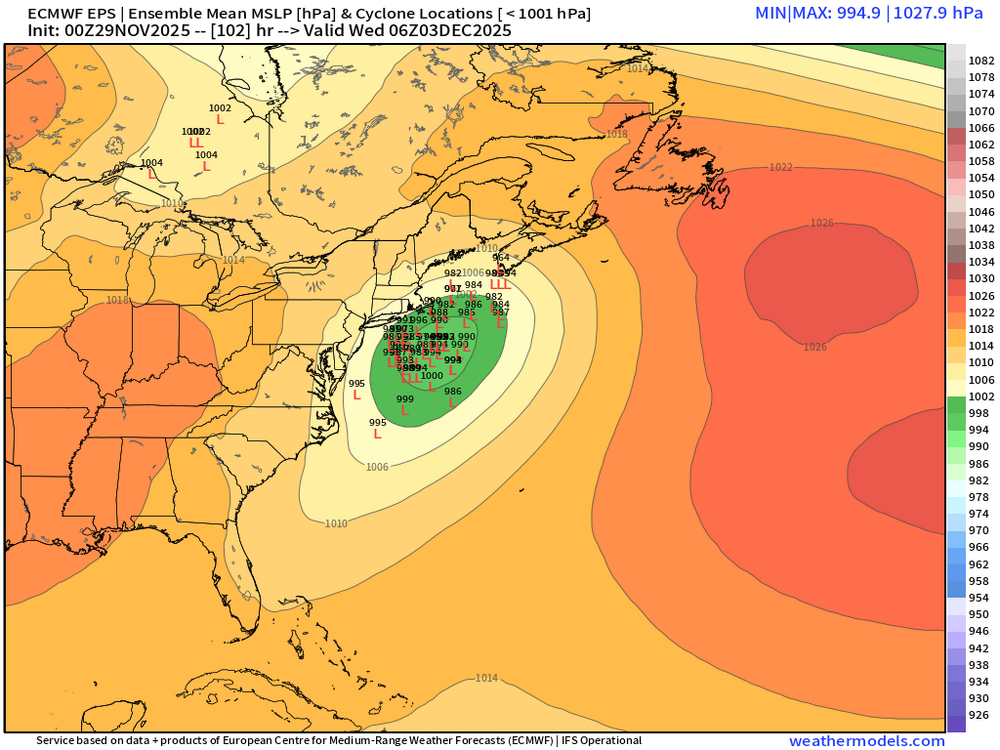
Inside 100h too. This is the time it needs to hold up. Numerous shortwaves and excellent cold in the region up to mid-December. Let’s get on the board first of course, but we might be in business throughout New England. Not an ideal pattern, but good enough. -

First Winter Storm to kickoff 2025-26 Winter season
WinterWolf replied to Baroclinic Zone's topic in New England
Funny thing…as soon as we say the pattern isn’t ripe for bombs, the Euro goes oh ya, take that gentlemen…and then follows it up with a gorgeous EPS. Ironic..yet beautiful too. -

First Winter Storm to kickoff 2025-26 Winter season
ORH_wxman replied to Baroclinic Zone's topic in New England
-

First Winter Storm to kickoff 2025-26 Winter season
40/70 Benchmark replied to Baroclinic Zone's topic in New England
Looks like it copied me. -

First Winter Storm to kickoff 2025-26 Winter season
40/70 Benchmark replied to Baroclinic Zone's topic in New England
Best EPS yet. -
can't use my phone tho
-

First Winter Storm to kickoff 2025-26 Winter season
40/70 Benchmark replied to Baroclinic Zone's topic in New England
Yea, GFS has the crazy gradient over KASH, EURO over Attleboro...place it over rt 128 with a parcel and a pear tree. -

First Winter Storm to kickoff 2025-26 Winter season
40/70 Benchmark replied to Baroclinic Zone's topic in New England
Similar to 06z, but a bit tamer. -
December can't suck forever, but I get it.
-
26.4 In York County, VA. IMBY
-

First Winter Storm to kickoff 2025-26 Winter season
WxWatcher007 replied to Baroclinic Zone's topic in New England
Absolute crush job in much of SNE. Dicey at the coast of course. -
high of 39.4F here - a proper January day. 30.7F at this hour.
-

Nov 28-30th Post Turkey Day Winter Storm
Jebman replied to Chicago Storm's topic in Lakes/Ohio Valley
Now THIS, is SNOW FOOTBALL..... Looks like they were playing in at least 9 inches of snow... Need to watch it on YouTube but it's definitely worth a look... -
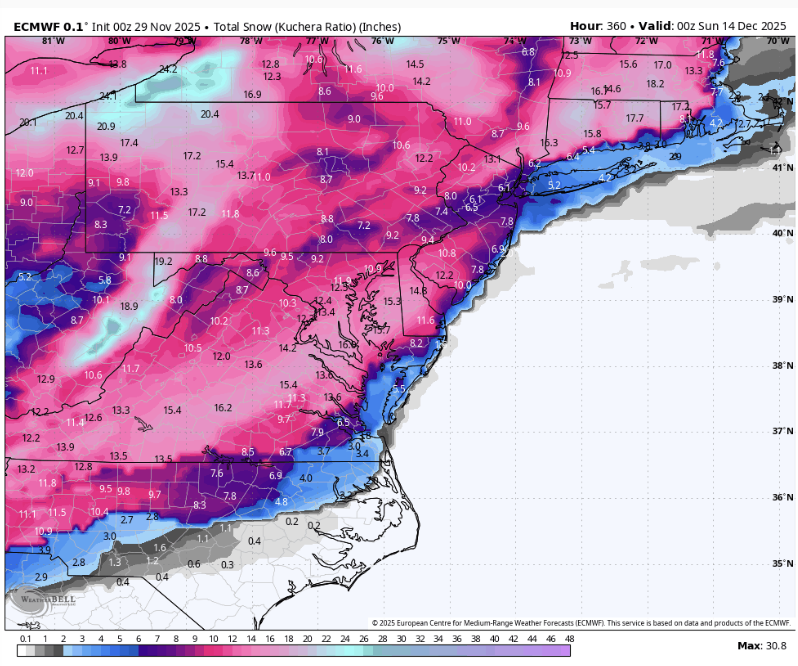
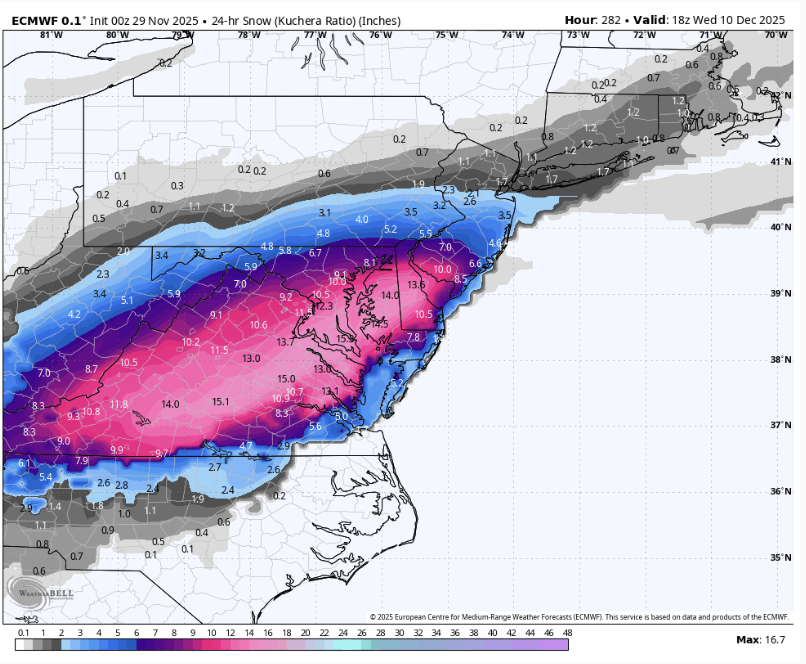
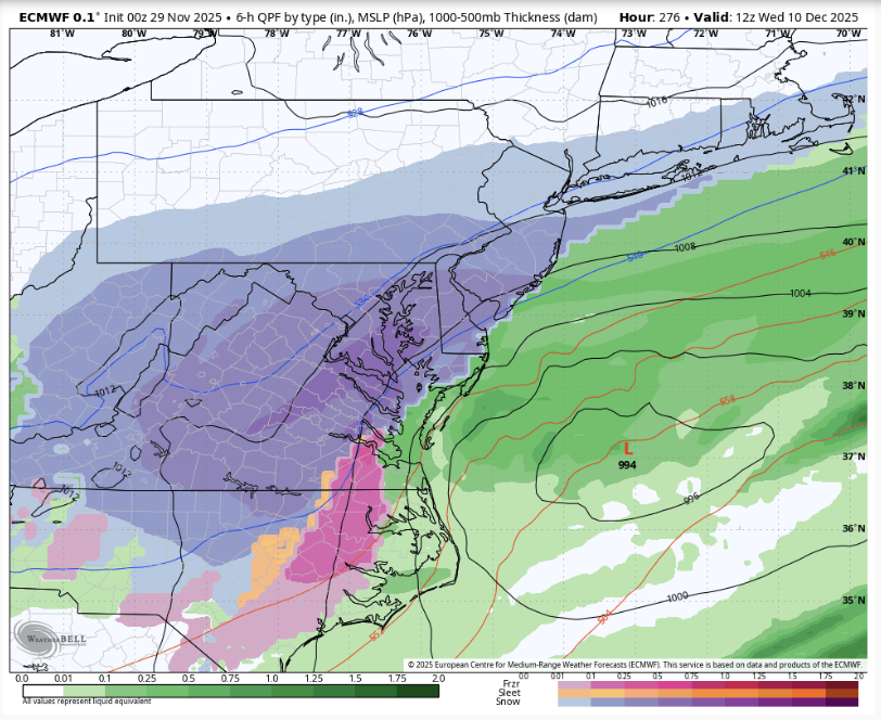
I'd be flipping estatic if it wasn't 282 hours away lol but at least it's another one to track. And this one seem colder
-

First Winter Storm to kickoff 2025-26 Winter season
ORH_wxman replied to Baroclinic Zone's topic in New England
That euro run is crazy. Still think compromise between euro and GFS is the most likely. -
Euro is approximately the same as 18z, maybe a little more precip and a little more north. But it also asks the lowlands to wait kindly for their turn.
-

Nov 28-30th Post Turkey Day Winter Storm
Mogget replied to Chicago Storm's topic in Lakes/Ohio Valley
Light snow has begun and it’s about 4 hours earlier than expected. -
Too early to say and too many unknowns. A weaker system without good dynamics, weaker cold push in front of the storm, etc could ruin it even with a better track. Stronger storm obviously brings the possibility it's too amped and has strong onshore flow. I'd say there's a narrow Goldilocks zone for the city to get some decent snow, but very narrow with a dynamic enough system, good cold push and good track. The possibilities expand a lot more NW of the city which is the usual especially this time of year.
-

First Winter Storm to kickoff 2025-26 Winter season
George001 replied to Baroclinic Zone's topic in New England
Euro is a nuke

