All Activity
- Past hour
-

July 2025 Discussion-OBS - seasonable summer variability
vegan_edible replied to wdrag's topic in New York City Metro
no sky july as we'd say in san diego -
Today will be our last warm and humid day till late in the upcoming work week. Temperatures tomorrow and Tuesday may struggle to escape the 70's. Nighttime lows should reach the low to mid 60's tomorrow morning and the upper 50's by Tuesday morning. This will be a great chance to open up those windows and get some fresh air in the place! Any shower chances look to be later today with the cold front. We start a warmup by Thursday with 90's possible to close out the work week.

-

E PA/NJ/DE Summer 2025 Obs/Discussion
ChescoWx replied to Hurricane Agnes's topic in Philadelphia Region
Today will be our last warm and humid day till late in the upcoming work week. Temperatures tomorrow and Tuesday may struggle to escape the 70's. Nighttime lows should reach the low to mid 60's tomorrow morning and the upper 50's by Tuesday morning. This will be a great chance to open up those windows and get some fresh air in the place! Any shower chances look to be later today with the cold front. We start a warmup by Thursday with 90's possible to close out the work week.
-

July 2025 Discussion-OBS - seasonable summer variability
SACRUS replied to wdrag's topic in New York City Metro
Clearing looks less likely and would lower range of the highs today - unless there is some rapid burning up of clouds. The May Grey - Jun Gloom, July grey sky syndrome continues especially on weekends. -
July 2025 Discussion-OBS - seasonable summer variability
SACRUS replied to wdrag's topic in New York City Metro
At EWR only two negative departures in July so far, maybe get 1,2 more between Mon - Wed before going much above by Thu - Mon. At JFK no below normal days this month (even while missing 4 days of intra hour highs) 4 below normal days at LGA with 3 of them -1. 3 at NYC even with the challenged high/maxes. -
July 2025 Discussion-OBS - seasonable summer variability
SACRUS replied to wdrag's topic in New York City Metro
Slowly seeing the ridge build back west into the MS valley - strongest heat pulls back west but overoll warmer 7/27 - 7/31, before we see heat expanding east again towards 8/3. Euro similar to the CM C -
We may finally break our now 30 day streak of the temperature not dropping below 64F at PIT tomorrow morning, with an even better chance on Tuesday morning. I have my doubts that PIT drops below 60, but Tuesday morning will likely be our only chance of that happening in July.
-
July 2025 Discussion-OBS - seasonable summer variability
SACRUS replied to wdrag's topic in New York City Metro
Records: Highs: EWR: 101 (1980) NYC: 101 (1980) LGA: 101 (1991) JFK: 99 (2019) New Brnswick: 99 (1999) Lows: EWR: 59 (1997) NYC: 55 (1890) LGA: 62 (1997) JFK: 58 (1965) New Brnswick: 49 (1923) Historical: 1915: A record high temperature of 115 degrees occurred in Yosemite Valley at the National Park Headquarters, California (around 4,000 feet elevation). This reading was the warmest day in a streak of 7 consecutive days of 110 degrees or higher at Yosemite Valley from the 19th through the 25th. 1921: Montana registered its record maximum 24 hour precipitation as 11.50 inches of rain fell at Circle. (Ref. Wilson Wx. History) 1930 - The temperature at Washington D.C. soared to an all-time record of 106 degrees. The next day Millsboro reached 110 degrees to set a record for the state of Delaware. July 1930 was one of the hottest and driest summers in the U.S., particularly in the Missouri Valley where severe drought conditions developed. Toward the end of the month state records were set for Kentucky with 114 degrees, and Mississippi with 115 degrees. (David Ludlum) 1934 - The temperature at Keokuk, IA, soared to 118 degrees to establish a state record. (The Weather Channel) 1946: The temperature at Medford, OR soared to an all-time high of 115° to begin a two week heat wave. During that Oregon heat wave the mercury hit 100° at Sexton Summit for the only time in 40 years of records. (Extreme Weather p. 276, by Christopher C. Burt) 1953 - Twenty-two inches of hail reportedly fell northeast of Dickinson, ND. (The Weather Channel) 1975: Annandale, Fairfax County, VA 16 people were struck and injured while picnicking. (Ref. Lightning - Virginia Weather History) 1977: A flash flood hits Johnstown, Pennsylvania, on this day in 1977, killing 84 people and causing millions of dollars in damages. This flood came 88 years after the infamous Great Flood of 1889 that killed more than 2,000 people in Johnstown. 1986 - The temperature at Charleston, SC, hit 104 degrees for the second day in a row to tie their all-time record high. (The Weather Channel) 1987 - Thunderstorms produced severe weather across Minnesota, Wisconsin and Michigan. Thunderstorms produced wind gusts to 87 mph at Mosinee, WI, and strong thunderstorm winds capsized twenty-six boats on Grand Traverse Bay drowning two women. Thunderstorms produced nine inches of rain at Shakopee, MN, with 7.83 inches reported in six hours at Chaska, MN. Thunderstorms in north central Nebraska produced hail as large as golf balls in southwestern Cherry County, which accumulated to a depth of 12 inches. (The National Weather Summary) (Storm Data) 1988 - The temperature at Redding, CA, soared to an all-time record high of 118 degrees. Showers and thunderstorms produced much needed rains from New England to southern Texas. Salem, IN, was deluged with 7.2 inches of rain resulting in flash flooding. (The National Weather Summary) 1989 - Showers and thunderstorms in the Middle Atlantic Coast Region soaked Wilmington, DE, with 2.28 inches of rain, pushing their total for the period May through July past the previous record of 22.43 inches. Heavy rain over that three month period virtually wiped out a 16.82 inch deficit which had been building since drought conditions began in 1985. Thunderstorms in central Indiana deluged Lebanon with 6.50 inches of rain in twelve hours, and thunderstorms over Florida produced wind gusts to 84 mph at Flagler Beach. (The National Weather Summary) (Storm Data) 1993: Heavy rains caused flash flooding in the Black Hills of South Dakota. 2.5 inches of rain fell within 30 minutes causing flash flooding in the Lead/Deadwood area and the northern Black Hills. The rapid runoff from the rains also caused numerous mudslides. The mudslides were as deep as three feet on area highways and even washed out a few roads. (Ref. Wilson Wx. History) 1993: Seattle, WA recorded their record maximum temperature of 100 °F which was also recorded on June 9, 1955. (Extreme Weather p. 278, by Christopher C. Burt) 1994: Several separate lightning bolts struck Camp Pickett, VA injuring seven officers. Two suffered serious injuries and had to be resuscitated several times. Most of the men were injured while inside tents with metal poles. (Ref. Lightning - Virginia Weather History) 1997: 32.54 inches of rain fell at Dauphin Island Sea Lab during the slow passage of Hurricane Danny. This set Alabama’s record 24-hour maximum precipitation record. In total 36.74 inches of rain was dumped by Danny here, 26 inches of which fell in just 7 hours the previous day. (Ref. Wilson Wx. History) 2003: A hailstorm (had ping-pong to baseball size) damaged most houses and vehicles on the east side of North Platte Nebraska; $7 million damage. A woman was struck on her head by a large hailstone in the Wal-Mart parking lot. She had to be taken to the hospital for stitches. (Weather Guide Calendar with Phenomenal Weather Events 2007 Accord Publishing, USA) 2005: Hurricane Emily made landfall in northern Mexico. When the central pressure fell to 29.43 inches of mercury, and its sustained winds reached 160 mph on the 16th, Emily became the strongest hurricane ever to form before August, breaking a record set by Hurricane Dennis just six days before. It was also the earliest Category 5 hurricane ever recorded in the Atlantic basin, beating Hurricane Allen's old record by nearly three weeks. -

July 2025 Discussion-OBS - seasonable summer variability
LongBeachSurfFreak replied to wdrag's topic in New York City Metro
Drove through localized flash flooding on the southern state right at the meadow brook. That tiny cell has some insane rates. -

July 2025 Discussion-OBS - seasonable summer variability
bluewave replied to wdrag's topic in New York City Metro
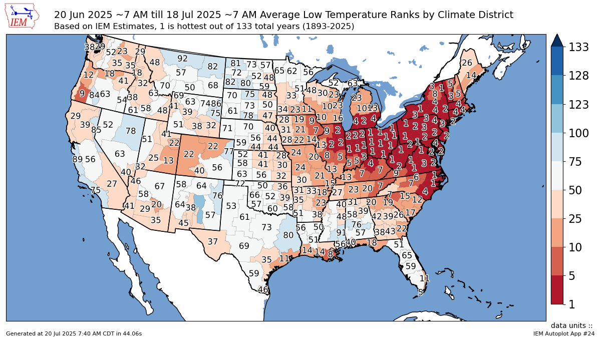
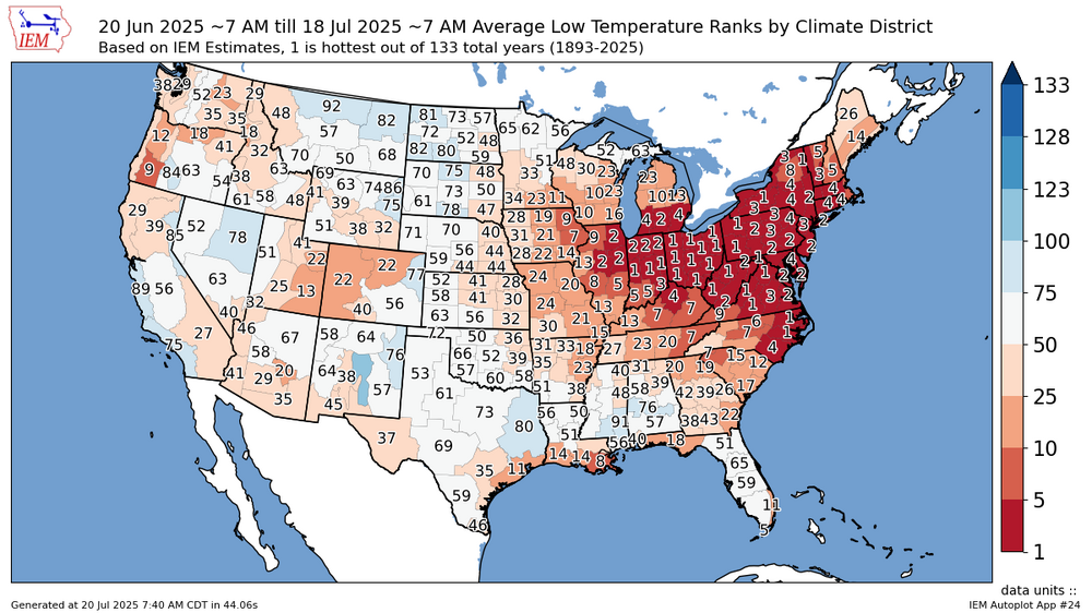
While the high temperature rankings have been impressive over the last month, the record high dew points have made the low temperature rankings even higher. The Hudson Valley is ranked 4th for warmest highs last month. But the whole area is top 2-3 warmest for the lows.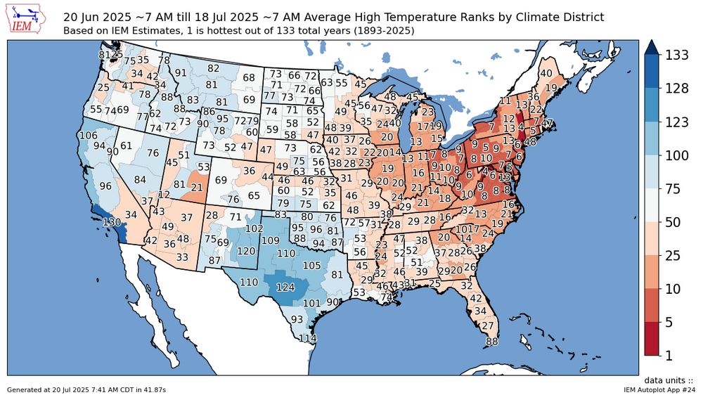
-

July 2025 Discussion-OBS - seasonable summer variability
lee59 replied to wdrag's topic in New York City Metro
rain here, .12 so far. -
Their was a dieing heavy shower about 70 miles to your NW. It could be the Carroll County stuff. I was in Easton a few years ago. I could see the anvil from a storm in Central PA. I find that kinds stuff interesting.
-

July 2025 Obs/Disco ... possible historic month for heat
Great Snow 1717 replied to Typhoon Tip's topic in New England
Off the top of my head I don't recall one. NY state is well behind their record pace of 2024 and seems in line for a normal number of tornadoes this year. Here in the winter wonderland aka methuen we haven't had anything close to a severe thunderstorm.... -
I have The Open on while I finish my coffee, NBC just showed a commercial for the Winter Olympics…it’s coming.
-
Thats crazy, there is a storm as you mentioned to his NW, to me it looks like in North centreal MD moving East.
-
July 2025 Discussion-OBS - seasonable summer variability
SACRUS replied to wdrag's topic in New York City Metro
79 / 74 mostly cloudy. Clouds the caveat today for borderline areas getting to 90 and hotter areas getting to the mid 90s. Clouds wanna hang tough this year - cloud magnet in full force today. Sunnier drier / cooler Mon - Wed - nice stretch similar to the Jul 4 - 5th days. Mainly mid - upper 80s in the hot areas. Ridge building over the area by later Wed with heat expanding by Thu into next weekend. Strong heat Thu - Sat (95+). Ridge wanes and pulls west and while warm to hot - some onshore and rain / storms by the 27. Break in the heat looks brief with ridge out west expanding and raising heights towards early next month. 7/20 : Hot / Humid clouds some isolated showers 7/21 - 7/23 : Cooler / Drier - Gorgeous sunny 7/24 - 7/27 : Hot / Humid - Strong heat 25-26, storms chances by later Sat/Sun next weekend 7/28 - Beyond : Ridge pulling west - Overall warm-hot / humid Weter -
I don’t see anything else on radar? It is really far. But that’s the right direction.
-
July 2025 Obs/Disco ... possible historic month for heat
Great Snow 1717 replied to Typhoon Tip's topic in New England
correct! -

July 2025 Obs/Disco ... possible historic month for heat
Brewbeer replied to Typhoon Tip's topic in New England
the only thing ugly about 80/55 are all the posts calling that weather ugly -
Mount Holly states there will be some mixing today during the afternoon hours, so dew points may not reach extreme levels at that time. Presently my DP is 76, very steamy ! Also, seeing some storms form in North central Maryland moving East. Worse area appears to be the Delmarva region where it almost reaches heat advisory levels. Increasing southwest flow will usher a warmer and more humid airmass into the region. Highs today will top off in the upper 80s to around 90. Surface dew points will generally be in the low to mid 70s, but afternoon mixing should keep dew points from getting into the upper 70s. Will blend the CONSALL and NBM guidance for dew points today, and that will keep dew points from getting as high as the NBM. Max heat index values will be in the mid to upper 90s, and near 100 in Delmarva, which will be just below Heat Advisory criteria.
-
Rather remarkable, no wonder why so many reports of flooding in the area this past month. This trend looks to continue despite a break or two.
-

July 2025 Obs/Disco ... possible historic month for heat
HoarfrostHubb replied to Typhoon Tip's topic in New England
Also, any confirmed tornadoes anywhere in New England this year? -
July 2025 Obs/Disco ... possible historic month for heat
HoarfrostHubb replied to Typhoon Tip's topic in New England
Nice to see some sun and blue skies this morning. -
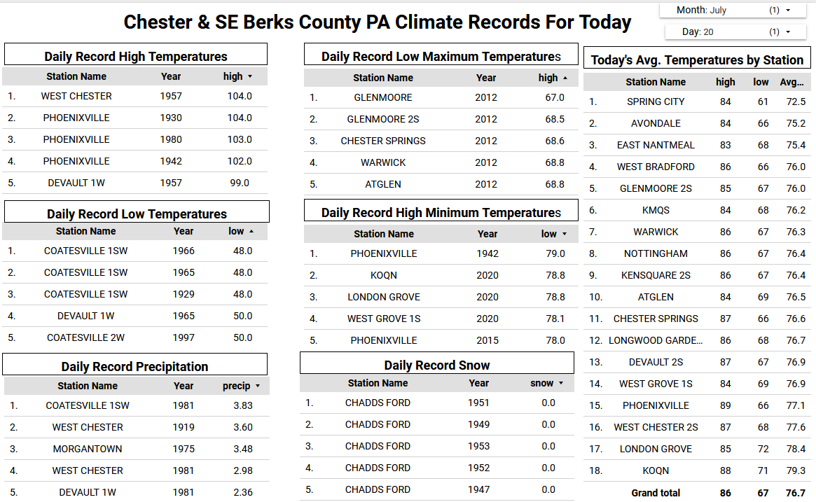
JUST missed a 'warm minimum' for the date. 68.7 low, record is 69 from 1986. Currently 71.1/68.9 at 8:10 am.
-
Yeah since June 20th or so we’ve had only a few breaks from the humidity. Hopefully it reverts to the mean with a below normal humidity August but it probably won’t