All Activity
- Past hour
-
Last year 2009 was my top analog, and I actually think that worked out pretty well. This year it's closer to the bottom of the list and barely made the cut. I thought I would have more time once soccer ended, I coach both my kids teams, but I took on a lot more at work and honestly I'm not sure if I'll have time to do a full in depth seasonal forecast but I did take an hour to identify the analogs using my formula. I think I am going to run a new anomaly mean plot where I weight them.
-

November 2025 general discussions and probable topic derailings ...
weatherwiz replied to Typhoon Tip's topic in New England
At some point soon it will change and we will get crushed. -

November 2025 general discussions and probable topic derailings ...
dryslot replied to Typhoon Tip's topic in New England
Apparently, But its a preliminary map and i would think they would tighten that up going forward. -
November 2025 general discussions and probable topic derailings ...
dryslot replied to Typhoon Tip's topic in New England
About sums it up lol -
 3-11” is a real range now?
 -
32.8 this morning.
-
 Gotta love the 'ole 3-11" and 1-6" forecast ranges.....must really boost scores.
 -
November 2025 general discussions and probable topic derailings ...
weatherwiz replied to Typhoon Tip's topic in New England
"EPS looks good" "EPS looks good" blah blah blah, tired of hearing it. It's the same routine every year. 1. EPS shows a big pattern change around Thanksgiving 2. Looks like EPS is delaying the pattern change to around Dec 10. 3. EPS is delaying the pattern change to around Christmas, but don't worry, it's delayed not denied. 4. Well we're into the New Year, but winter us just about to begin. EPS shows the pattern changing in a big way by the 10th. 5. Well looks like the pattern change doesn't occur until the end of Jan but we should be in store for a big Feb...look at that trough on the EPS!!!! 6. winter's over. just couldn't cash in. March comes, finally get a good pattern - now a bit too warm outside of northern New England and elevation. Rinse, wash, repeat. -
There is a significant lag between an increase in global atmospheric CO2 & CH4 concentrations and an increase in mean continental surface atmospheric temperature. Most data sources show global temperature increased most significantly after about 1920. In the US, there appears to have been mean warming in the early part of the 20th century, following by cooling through ~ the 1970s, followed by the period of pronounced warming that we're in. The 1930s were warmer than parts of earlier centuries for sure. This was likely the result of a combination of astronomical and anthropogenic climate factors. The rate and magnitude of current warming is much more significant than previously observed during historical times. The data that bluewave showed does suggest that low snow years in the 1930s were more related to total precipitation than to temperature compared to the present. Though temperature in the 1930s was likely more of a factor than during the 18th or early 19th centuries. And I suspect persistent under-measurement of snowfall was also a factor.
-

November 2025 general discussions and probable topic derailings ...
TheMainer replied to Typhoon Tip's topic in New England
Im happy it's swinging north, we don't need it yet, 1-3 is fine with me. We're going to Kokadjo to look at one of their groomers for sale Sunday afternoon and might have enough snow to drive it around the yard there and test everything -
November 2025 general discussions and probable topic derailings ...
dryslot replied to Typhoon Tip's topic in New England
And so it begins for places that it should.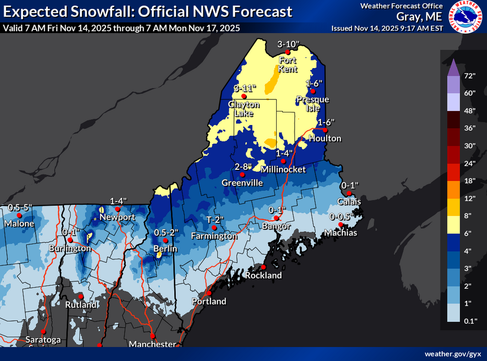
-

E PA/NJ/DE Autumn 2025 Obs/Discussion
JTA66 replied to PhiEaglesfan712's topic in Philadelphia Region
Can't say I know a thing about strat-warming events. But it "seems" when the do occur, the cold gets dumped on the other side of the globe. My weenie approach to winter weather: Expect nothing and be happy if ya get sumthin'. -
Thats great. I don't want rain and 42 on Thanksgiving while the interior/appalachians from Morgantown to Ithaca NY get 10" of paste!
-
November 2025 general discussions and probable topic derailings ...
weatherwiz replied to Typhoon Tip's topic in New England
What a colossal joke between the Euro and GFS with the overall evolution and structure of the pattern next week and it goes beyond this. It's legit been increasingly difficult to find any strong model consensus or consistency. How the hell is anyone really supposed to glean a signal when assessing medium-to-long range (particularly longer range and by longer range I mean 8-10+ days out, not seasonal) outside of just basing off "analogs". Literally, who cares what EPS's show past D10 or what the EPO, NAO, PNA, AO, whatever are "forecast" to do. These facets have been irrelevant the last several years and when we've seen these features evolve as is...what was expected in terms out production was still wrong. Until we can figure out what the hell is going on with this model inconsistency and discrepancy it's all really just a big joke. -
I haven't really been paying much attention but i have seen that a cold start is anticipated but what looks to change to get the moisture flowing? This dry has been stubborn as heck...maybe we can have a cold January and a super wet month like we had in the summer? I forget what month it was but it was glorious...time that with some cold and it can be dry the other months for all i care.
-
Sure, if we take a deterministic model verbatim at hour 324.
-

November 2025 general discussions and probable topic derailings ...
jbenedet replied to Typhoon Tip's topic in New England
You look at tomorrow’s event and it just seems like the whole Jet/track is displaced 100 miles north given climo and the sig -NAO pattern. But background warmth in eastern Canada doing its thing…It doesn’t snow much in November, correct; but, this storm/evolution would be one way in which it could happen and it’s not even close in my hood. That, to me, is one key example on how marginal warming is having outsized effects. -
For the moment it seems that the best pattern is not going to be Thanksgiving weekend, which as I’ve said, is a-ok with me. Much rather the second or third week of December and that seems to be the flavor of the long range guidance right now. That’s what @griteaterhas been saying as well.
-
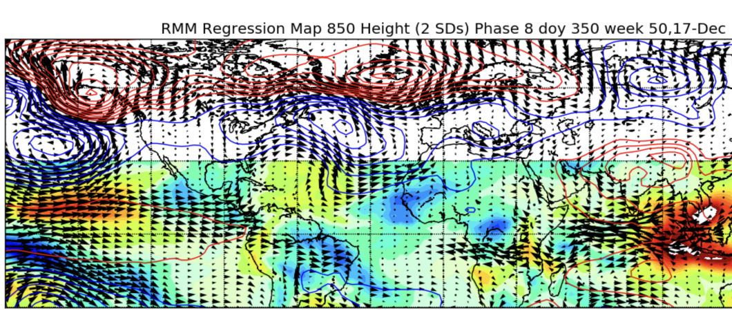
That's an improvement on the euro since yesterday, OLR mins closer to the dateline and all. Here's a semblance of what that transition might look like. Pretty hard to get those strong westerlies in the phase 8 map with la niña easterlies so we'll see how they contend. Id be surprised if the MJO stayes in 8 for long but we'll see if there's some constructive interference with easterly eq. rossby to prolong convection in the region a bit. That would be best cast scenario

-
Great point. I think it would be hard to argue cape may has a better climo for snow than central park. Yet they got multiple 4" events last winter. Central park is has just been very very unlucky recently.
-
I’ll never understand the obsession with CO2 concentrations as the key determinative factor of whether or not it can or will snow again in the tri-state area when there so many other factors at play. Current CO2 levels are .043% of atmospheric content; below .02%, plant life, and life as we know it, ceases to exist. This is not to say I believe the climate is static; far from it, as Long Island itself is a glacial moraine. Nor do I believe we should not be looking into more efficient sources of long term viability in terms of power, as, somewhat ironically, we are all contributing to “AGW” every time we long onto this forum. Now back to my cave…
-
pretty sure LGA got a 4" event last winter.
-
11 inches of precip versus 9 is really not that much. I don't really think you can chalk up the lack of snow in the late 20s early 30s to dryness. It was likely just shit luck with the storm tracks being west of the region. Of course one can argue with climate change it's more likely we get these warmer storm tracks.
-

November 2025 general discussions and probable topic derailings ...
MJO812 replied to Typhoon Tip's topic in New England
Its the same people


.thumb.jpeg.406ecda2eec9e267302c22b9f128fe3c.jpeg)