All Activity
- Past hour
-
Yeah. It is a different look in the long range from the overnight runs. GFS ops looks to dump the cold more in the west versus locked up in Canada. But teleconnections show the NAO heading negative during that time while the PNA looks like its headed positive. Who knows?
-
Yeah we are not here for repeated torchmas shit from you
-
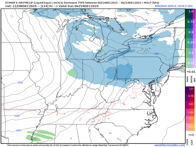
Ain’t much Sunday. Light and north of last run.
-
I think we can juice that up. There were some improvements at 500
-

E PA/NJ/DE Winter 2025-26 Obs/Discussion
Hurricane Agnes replied to LVblizzard's topic in Philadelphia Region
I bottomed out at 15 this morning right around sunrise and that was the lowest since my Janury 21 - 23 triple single-digit temps of 8F, 6F, and 8F, where the dp bottomed out at 1. Currently sunny and 30 with dp up to 8. I just saw a news blip that since the state of NJ declared a Drought Warning, they are asking folks to conserve water. Looks like it's drying up quick in western NJ and eastern PA. -
Euro is meh for Sunday again
-
UKMET completely lost the storm for this weekend squashes it down south. I don't understand how these models work, if it shows rain a week from now it'll be the truth and it'll rain next week. but any snow even 3-4 days it'll somehow suppress the storm, inland run it and show rain or just squash it completely. Very tough for snow weenies nowadays! I am looking for a new hobby in the meantime maybe buying some cryptocurrencies may be in the works
-
I put as much stock in the day 16 GFS as I put in a preseason college football ranking… That being said there is a signal for a warmup that week but with MJO stuck in phase 8 I would be shocked if it was anything but a brief warmup before a front. We will see
-
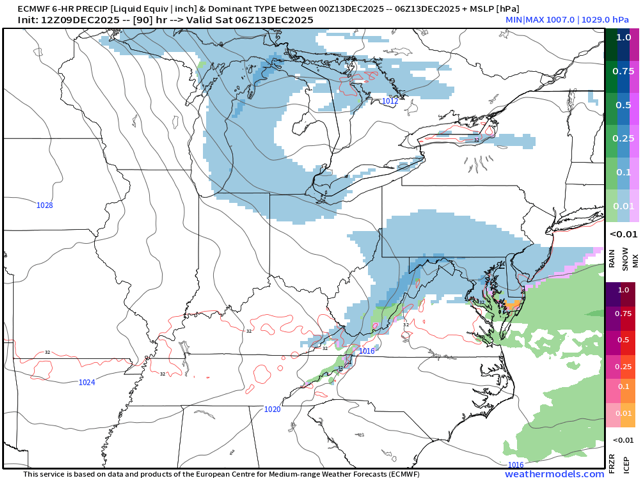
Euro still light event Friday
-
Sounds like there is one continuos supply of cold air, and not cutoff from any one region?
-
There was something special as a kid about waking up in the middle of the night to find the orange glare of the old street lights softened by unexpected heavy snow. Especially if it happened before a school day.
-
that's fooking great!!
-
i'm expecting it. need to finish raking some leaves.
-

Winter 2025-26 Short Range Discussion
WestMichigan replied to SchaumburgStormer's topic in Lakes/Ohio Valley
The Euro is saying Kent County is good, the GFS not as much. Less than 24 hrs away and still more variability in the models than I would have expected. -
This is the one I have been referencing analog wise although I did initially say two weeks ago that it’s 12/20 time frame but this is the next good shot
-
You can’t stop her. You can only hope to contain her.
-

E PA/NJ/DE Winter 2025-26 Obs/Discussion
RedSky replied to LVblizzard's topic in Philadelphia Region
Burgers sausages on the grill today's GFS Christmas, Griswold in the pool -
At least the 12z ED-209 looks better than 6z.
-
Long way out, though a warm up is likely; can’t expect to have multiple -10 days in perpetuity.
-
Euro AI is nothing for Friday outside the mountains. Sunday leans north of us, but dusting for DC, 1” for Baltimore, near 2” along M/D line
-

December 2025 regional war/obs/disco thread
Great Snow 1717 replied to Torch Tiger's topic in New England
My Christmas postcard to Ray...it should arrive by Friday! -
melting p good here, wonder what will be left of the pack by tomorrow morning
-

Pittsburgh/Western PA WINTER ‘25/‘26
RitualOfTheTrout replied to Burghblizz's topic in Upstate New York/Pennsylvania
Your probably right for the most part, but it was 11 degrees here this morning, then clouds moved in before any real sun could warm surfaces up. If we get a thump in the early morning hours, even if temps are marginal, it should have no problem accumulating especially on any subfreezing surfaces. Looks like more shots at some snow this weekend. Hopefully we can score a couple more events in the next 10 days, as it looks like the pattern is going to break down around Christmas. Who knows if it will actually happen that way or for how long, but ensembles are coming into agreement some sort of relaxation may be on the way. NWS seems to be biting onto this possibility as well. Confidence is increasing in a several day period where we have high temperatures some 15-20 degrees below average in the cP airmass through the weekend with highs in the 20s and lows in the teens or single digits. Cold air being entrenched across the region means any additional disturbances are likely to produce snow as the prevailing precip type areawide. While the overall pattern appears messy and ensembles are clearly struggling to agree on timing and intensity of any given wave, confidence is increase in at least one more shot at snowfall over the weekend before long term guidance finally has the eastern Canadian longwave trough breaking down. Stay tuned for more details as we get closer and confidence increases. -

December 2025 Short/Medium Range Forecast Thread
John1122 replied to John1122's topic in Tennessee Valley
The way it looks now, we may be dodging severe weather instead of snow. It'll be wild if we are -5 to -10 for half of December but my snowiest day of the season is November 10th, but that looks to be the case barring a miracle. -
Some shots from last night and this morning. We even had a little snowliage here:


