All Activity
- Past hour
-
But you picked 3 different locations where in one season they got more snow than Baltimore. One year. Over a longer period (10 years or more) none of those locations had more snow than Baltimore. That isn’t how climate works. One storm in one season is a fluke. If New Orleans got more snow over a 10 year or 30 year period then we can have this conversation.
-
How do I get that map from 2018 through now? That's the time period I really wanna see.
-
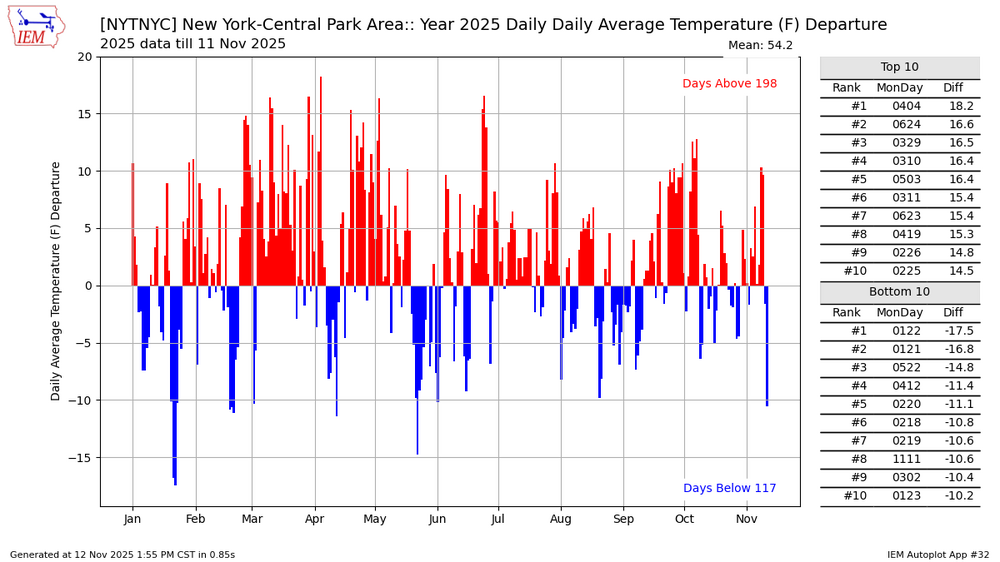
Yesterday was the first -10 at spots like NYC since May.
-
I must be misrembering then. I just know southern half has done better than the northern half of our sub since Dec 2018.. It's not one season but multiple ones since then. Precip boundary has been consistently south of here, hasn't it? NoVa has done better as well...but I could be wrong.
-
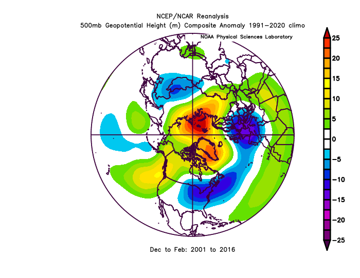
We are due for another negative cycle of the AO/NAO. However, don’t assume that fixes 100% of this. We had a very favorable long term cycle of the NHem long wave pattern from 2001-2016 and the sad fact was the mid Atlantic only has “average” snowfall during that period. NYC and Boston were setting all kinds of snowfall records though! This period was very similar to the pattern of 1958-1971 but the positive snowfall anomalies shifted further north and we were south of most of the snow. Similarly we were due for another god awful period with an unfavorable PDO/AO coinciding, but just like the last favorable cycle didn’t produce as much snow as previous ones, this bad cycle is producing even less snow than previous ones. So yes we will get a better period sometime with a run of a more favorable PDO and AO and it will snow more than it has the last 10 years. But don’t expect it to suddenly go back to what the results were in the 1960s or even what they were in the 2000-2016 period. The downward degradation of our snowfall will continue with shorter term highs and lows within the longer scale trend. Below was our mean Dec-Feb h5 from 2001-2016 and yet all we got from this was near mean snowfall. We should have been way above avg snow (like NYC and Boston were) with this pattern.
-

November 2025 general discussions and probable topic derailings ...
WinterWolf replied to Typhoon Tip's topic in New England
You gonna rock this year Chris. -
He’s just trying to be funny. It’s good to laugh at yourself. I do that all of the time! I’m my own best comedian when I laugh at myself as I have so much material! Come on, man, we all know that you enjoy pushing mildness in winter when you can back it up well (which to your credit you do), and that there are more that do the same on the opposite end sometimes without good evidence.
-
WeatherBell CFS maps are also a little bit gimmicky. TT shows a much different outcome.
-
looks like storm arrived 1915z
-
Spaceweatherlive.com they have a forum too.
-
Congrats Atlanta?
-
Can someone remind me of the key websites to monitor and what I am looking for again?
-
Pretty colors of the PV warming. Sent from my SM-G998U using Tapatalk
-
I glanced at this quickly and thought you said movie thread. I was excited until I realized it was Novie.
-
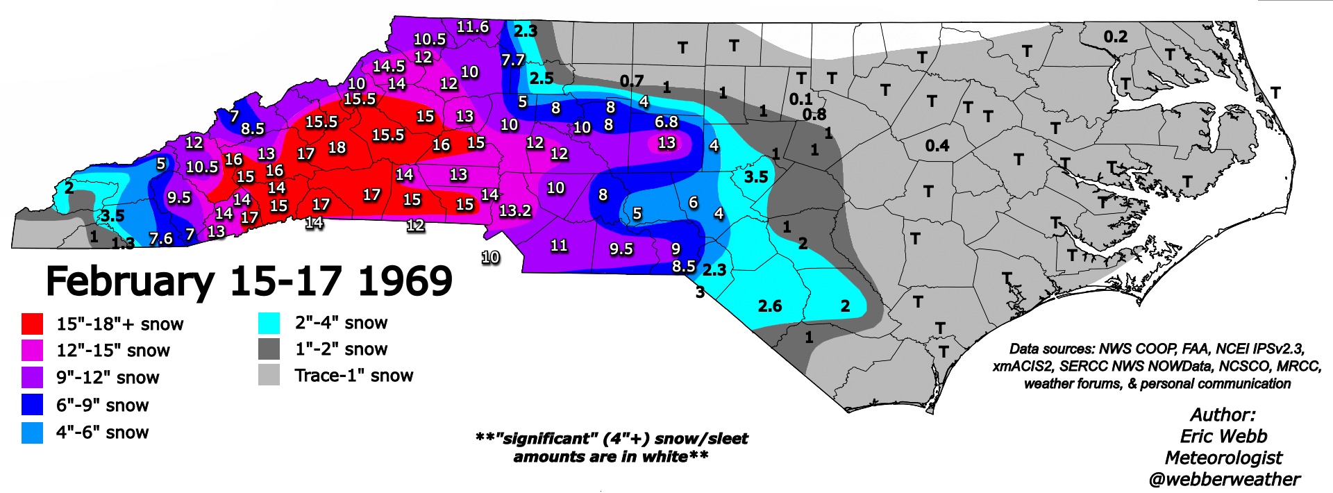
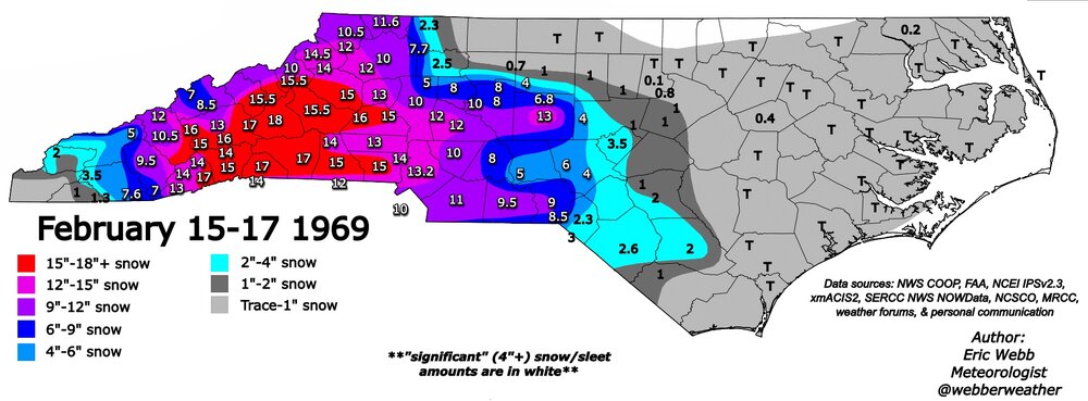
The 1968-69 winter has been brought up a lot recently. We got this beast that winter.
-
One specific location getting more snow in one specific season is a fluke. If you pull back and look over a 10/20/30 year period it is not snowing more to the south. One storm and one year is a fluke. An anomaly of short term randomness within the longer scale actual patterns. Same way 2010 was an anomaly for us, not some indication we get more snow than places in upstate NY that got less snow than Baltimore that one season.
-
 Sorry. The intensity of today's snow wasn't meant to be part of my post. Just more envisioning the tenure of the season being that a heavy band sets up on 93 to my east while I rot in the subby zone. #Negativity
 -

Occasional Thoughts on Climate Change
donsutherland1 replied to donsutherland1's topic in Climate Change
COP30 is on track to become yet another farce in the process to address climate change. It's agenda contains no items on mitigation. It contains no discussion of a phase-out of fossil fuels. At the same time, it punts the discussion of the Paris climate goal and progress toward that goal to COP31. It is yet another ratification of a status quo that is the primary driver of climate change.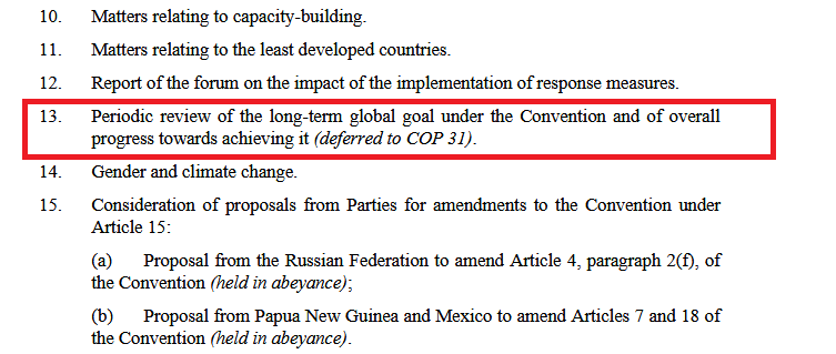
-
CME is hitting but its magnetic field is positive for now. We want strongly negative for the best show.
-
twice as cold as last January.... maybe 2014 level?
-
Leafageddon update . Heavy winds and rain Oaks laugh .
-
That’s my take also. Using one cherry picked location (where a single fluke storm hit) from one season to say “its snowing more to the south” is flawed methodology. If you pull back and use even a 10 year period or longer then it becomes apparent it is not in fact snowing more to our south.
-
Yep I was wrong. The sheath was positive though which doesn't mean anything until we get into the flux rope which we've seen can instantly flip negative (or stay positive)
-

November 2025 general discussions and probable topic derailings ...
powderfreak replied to Typhoon Tip's topic in New England
Daily snows. Dark November afternoons.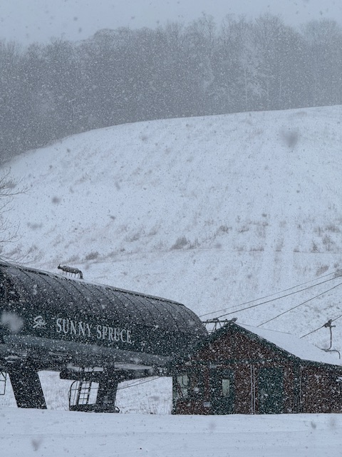
-
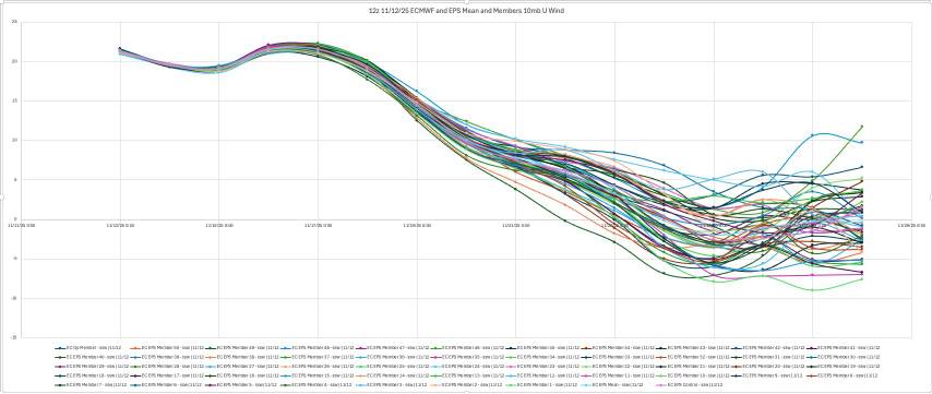
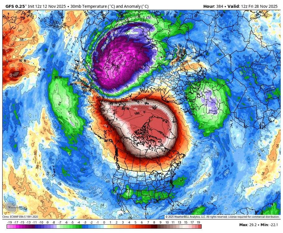
Great stuff from Allan Huffman. Today's 12z op ECMWF and EPS mean both show the 10mb U wind turning negative, meaning a change to an easterly wind direction over the polar regions and an #SSWE with 41 of 50 EPS members (82%) showing this reversal with 11/25 the day with the most negative members. Sudden Stratospheric Warming Events, can weaken the tropospheric polar vortex, allowing for increased high latitude blocking (-AO) and the enhanced risk for arctic air discharge into the mid-latitudes (North America, Europe, East Asia). A late November SSWE is relatively rare, and COULD help favor a cold start to meteorological winter(December). The last November SSWE was in 1968. Sent from my SM-G998U using Tapatalk