All Activity
- Past hour
-
I think July has the lowest standard deviation for monthly temps, so it doesn’t take much of an anomaly. The humidity definitely helped boost the overnight temps.
-
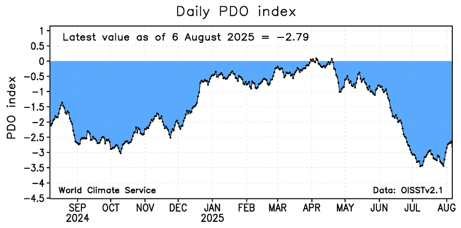
Cosigned. -PDO actually starting to reverse
-
If our weather is warmer and more like the mid Atlantic at least we could get severe every once in a while. It’s only fair
-
I was traumatized so much this winter with the GFS’s multi biblical blizzards only to be let down. Like an abusive lover, the GFS promised to never do it again if I took it back. And now look what’s happening. I gotta find a new hobby. I hear BASE jumping is fun….
-
 And since it'll be coming N at 50 mph, on the east side that means 205 mph winds! Bye Bye Fire Island
 -
Haven't had a good rainy day in weeks up here... Trees are badly hurting to the point leaves are dying and changing colors and the West River up 30 is damn near dry in spots, only thing I can think of to make this worse is getting an unusually brutally cold and snowy winter like the winters of yor in a few months then a very monsoon spring Sent from my SM-S166V using Tapatalk
-
Right-we all live at 1000 feet. I’ll give you my house in Chestnut Hill (Brookline part). High was 81-similar to Newton and the swamp as you call it.
-
2018 was the year when my first t-storm or thunder was in late Aug, nada before that! After all these years I still can't believe it. Total opposite this year, I'm at 20 and its not even a 3rd of Aug done with. Storms have been weak this summer. Got to 30C/86F first time in a min I saw good sunlight again. A long lived heat event is starting!
-
Couple rehab starts and back up to the big leagues.
-
23 90+ days year to date at ORD, not 24.
-
you're right, and even this "coc smoke" stretch (which was absolutely awful for the chambers of commerce(s) in every way) wasn't particularly cool.
- Today
-
Never broke, just needed a massage. Now standing tall and helping to squat Volkswagens.
-
Hit 91° at ORD and at MDW today. ...2025 90°+ Day Tally... 23 - ORD 23 - MDW 23 - DPA 22 - PWK 21 - ARR 18 - RFD 18 - LOT 13 - UGN
-
Perhaps nothing too "special" upcoming. I wish we could get 90+ for like two weeks straight for BDL, OWD, TAN etc. that would be amazing!
-
Back broke but surgically repaired 8/5, just a few therapy session away from go-time!
-
Anomalies are relative to climatology. 18C at 850 mb (for example) over CON is more anomalous than it is over PHL. CON bleeds and PHL pisses
-
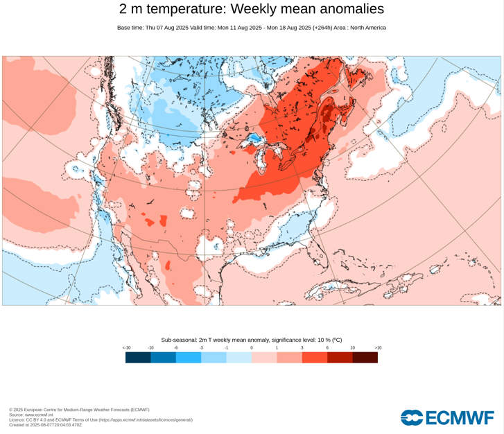
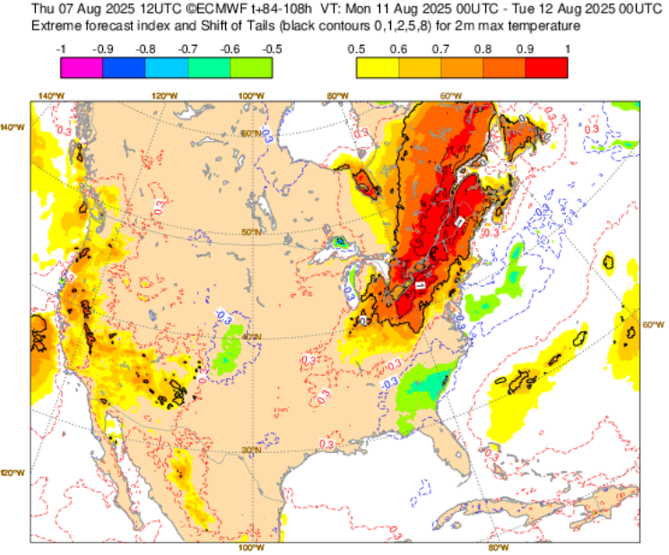
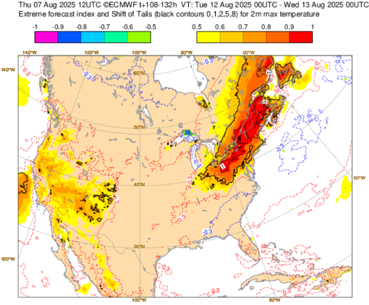
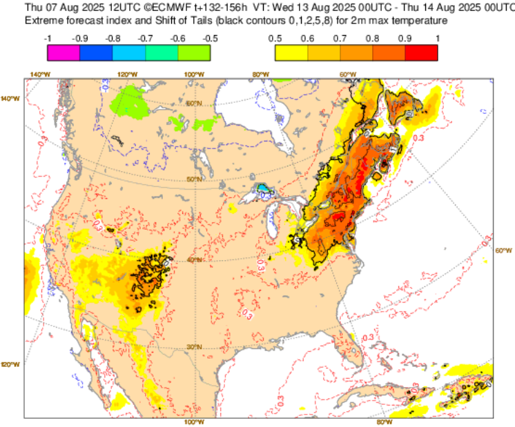
 Next week's heat is continuing to look more significant, even as the most anomalous heat will likely be focused on western and upstate New York, eastern Ontario (including Toronto), southern Quebec (including Montreal), and northern New England. In that area, daily records could be challenged during the peak of the heat. The latest ECMWF maps are below. Extreme Forecast Index (August 11-18): Monday, August 11: Tuesday, August 12: Wednesday, August 13: Weekly Temperature Anomalies:
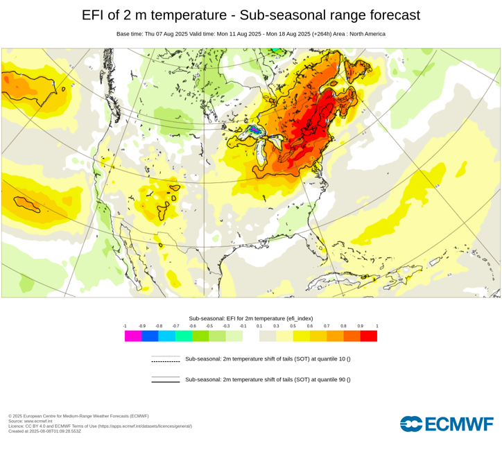
-
If not this year, soon. very very soon
-
 Newark and Central Park the same high temperature. They must have cut the trees in Central Park and took them over to Newark.
 -
After a high of 81, down to 66 now
-
Swimming in un- heated pools into Tgiving .. maybe cooking the bird at a pool party this year
-

Occasional Thoughts on Climate Change
Typhoon Tip replied to donsutherland1's topic in Climate Change
https://www.instagram.com/p/DNDngQCTCg4/?igsh=MTF4N3lpa2ozdDdxcw== -
So is everyone ready for a possible heat wave next week?
-
Smoke from Canada. It’s supposed to dissipate over the weekend before we get hot. Tonight Is a perfect summer evening.
-
The haze today was dumb. Hopefully, this doesn’t become a longterm trend. Looking forward to a southerly flow because it’ll mean less of a chance at smoky skies.


