All Activity
- Past hour
-
Temp down to 36 at Mammoth. Precip is steady moderate to heavy and appears to have gone over to ALL snow. Still no stickage. Still rain at Village level.
-

November 2025 general discussions and probable topic derailings ...
alex replied to Typhoon Tip's topic in New England
Must have gotten another 4-5 inches since this afternoon. Relentless. One of the best upslope events in a while.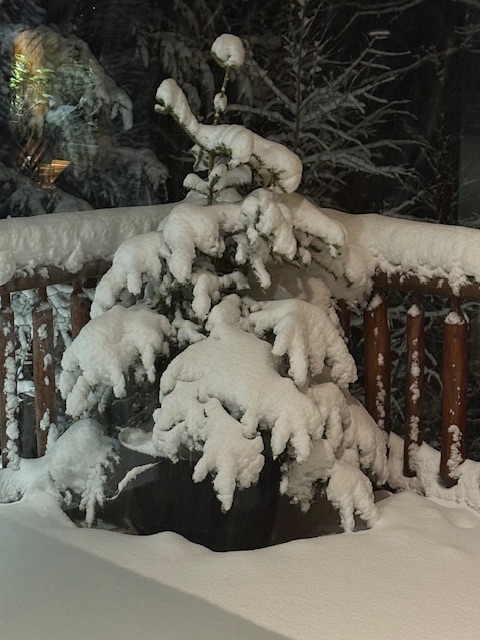
-
 Dude... You're like a windstorm.... Your predictions blow in every direction. You should look back on all your posts, especially during the Winter months.
 -
I just read that a SSW is not in motion. Is it right & is it good or bad? We shall see.
-

November 2025 general discussions and probable topic derailings ...
powderfreak replied to Typhoon Tip's topic in New England
Oh they are on, haha. That area isn’t heated though. -

November 2025 general discussions and probable topic derailings ...
dendrite replied to Typhoon Tip's topic in New England
For Will https://www.holland.org/snow-free-holland/ -

November 2025 general discussions and probable topic derailings ...
mreaves replied to Typhoon Tip's topic in New England
Thank god the sidewalk heater hasn’t come on yet. Will would be in here raging. - Today
-
Enjoy it! Moving to the mountains has been the best decision in my life. Or at least one of the best
-
Champaign county with the worst drought conditions observed in the state, virtually the entire county under extreme drought.
-

November 2025 general discussions and probable topic derailings ...
Torch Tiger replied to Typhoon Tip's topic in New England
Yeah I noticed lots of folks golfing in SNH. Hopefully no snow December and we keep it going -
Lovely. Not nearly as snowy here, but I already feel like this might be a winter to remember for me now that I'm at some elevation for the first time.
-
 I was right on that first flakes call and maybe I can go 2/2 by saying I do think that it'll be the first week of December that we get some sort of advisory level snowfall for interior SNE. I continue to like the pattern progression. Even though our last few winters have been absolute disasters we've done alright in the first half of December. It's not necessarily that we start slow, it's that we go into epic voids of activity as soon as we get on the board. 1.7" on 12/5/24 4.1" on 12/11/22 1.7" on 12/8/21 2.0" on 12/5/20 (followed up by the KU on 12/16-17) 8.6" on 12/1-3/19 2.8" on 12/11/19
 -
As of 5.33pm PST, we are now seeing very WET snow falling at both Woolly Cam and at the Main Lodge. It's 38 degrees, ground is soaked, stickage is extremely unlikely. https://www.mammothmountain.com/on-the-mountain/mammoth-webcam/main-lodge https://www.mammothmountain.com/on-the-mountain/mammoth-webcam/woolly-cam At Woolly you can make out rain impacting the pavement so what this may well be is a snow/rain mix. At any rate temps are far above freezing. What a waste of 5 inches of water. You can see hydrometeor impacts in water puddles on the Main Lodge grounds too. This is probably a moderate to heavy extremely wet snow and plain rain mix, in an upper 30s temperature environment in the presence of extremely wet soaked mud, mud that is well above freezing which shall rule out any stickage whatsoever. It probably won't cave until next week's colder storm. It's a real severe punch right in the gut, to realize that Mammoth at 9000 feet can get Washington DC'd, too. At least Mc Coy Station at 9,630 feet is seeing some accumulation on the grounds. Damn.
-
Did he say El Nino is fading?
-
 Attack ? No attack bruh . Have at a snowy winter . Hope you win . To me looks better than last year but not by much
 -

2025-2026 Fall/Winter Mountain Thread
Maggie Valley Steve replied to Buckethead's topic in Southeastern States
I'll take a late November/early December-EPO/+PNA regime now showing up on the ensembles any day. I expect some crazy swings in the deterministic guidance the next 7 to 10 days. Patience grasshoppers. -

November 2025 general discussions and probable topic derailings ...
Ginx snewx replied to Typhoon Tip's topic in New England
Why the attack? Was just saying it starts mid Dec every year. You are losing it. -
Yeah pretty classic -EPO showing up for the last few days of the month Models at that range did just completely lose a sustained -NAO, so let's see if it hold when we get closer... but it does match weak-negative ENSO/strong -QBO analogs for late Nov/early Dec
-

Central PA Fall Discussions and Obs
mahantango#1 replied to ChescoWx's topic in Upstate New York/Pennsylvania
You miss that know it all. You should have taken that individual for a long ride in your truck an dropped it off as unclaimed freight -
Fort Collins up to 75.1 I wish I could turn on the weather magnets and get you guys some rain and snow. My place in Ohio had more snow than Estes Park this week. It wasn't much.
-
Still waiting for my first Snow Squall Warning. I'm surprised how many offices in the Midwest haven't issued one.
-
When was my winter idea last wrong? You go big snow every year . Waiting for the snowy poem
-
November 2025 general discussions and probable topic derailings ...
Ginx snewx replied to Typhoon Tip's topic in New England
Lol every year -
^yeah, GEFS and EPS both have a strong +PNA/-EPO developing around Thanksgiving with our -NAO fading away. My instinct is that the PNA+EPO ridging is more useful for our early season snow chances since it’s a more effective cold air delivery mechanism and we need more anomalous BN temps in early December to snow.
-
+PNA pattern trying to build at 384hr on the 18z GEFS. As PSUhoffman posted, we can get snow from this pattern. Let's see if it develops and holds as we get closer


