All Activity
- Past hour
-
Sun has started poppin' out here. I dig it.
-
We’re in an overall drought the past few years, warm or cold. .
-

December 2025 regional war/obs/disco thread
40/70 Benchmark replied to Torch Tiger's topic in New England
No doubt. -
I'm impressed that DCA made it to 20° with no snow cover before Christmas.
-
Snow town! Went for a walk in the woods this morning and everything looks super pretty with temps staying below 30 today
-
That sucks, I'm gonna really miss these frigid temps and occasional cartoppers. But actually I'll be out west during that time, so it probably will end up snowing here.
-
Flakes flying in the SW metro. Maybe we stay all snow, latest hi res guidance really upping the snow total for MSP.
-

December 2025 regional war/obs/disco thread
SnowGoose69 replied to Torch Tiger's topic in New England
There has been many cases in the last 2-3 winters where both the GEFS/EPS show a pattern at like D12-16 that seemingly not a single Op run over that few days ever shows, if anything its the reverse and then the Op idea verifies more 2 weeks later. Not sure why that would happen, it shouldn't but I have seen it more than you'd think is normal. -
When you have summer heat ridge heights near the winter solstice, I'm guessing it's hard to wash that out even with other ensemble members.
-
2025-2026 ENSO
40/70 Benchmark replied to 40/70 Benchmark's topic in Weather Forecasting and Discussion
Yea, I really just watch the tri-monthly value. -
I trust the GFS 2 weeks out as much as I trust the ravens defense lol
-
My point exactly. 2 weeks out going to flip flop quite a bit. Saw that over the last 24 hours already wrt that time period
-
That would be God-awful to see in JULY (let alone December)!! We'd be talking triple digits if it were summer!
-

Winter 2025-26 Medium/Long Range Discussion
TheClimateChanger replied to michsnowfreak's topic in Lakes/Ohio Valley
Severe weather outbreak? -

December 2025 regional war/obs/disco thread
brooklynwx99 replied to Torch Tiger's topic in New England
the GEFS is so horribly underdispersive that the OP probably is influencing its ensemble 16 days later -

Winter 2025-26 Medium/Long Range Discussion
WestMichigan replied to michsnowfreak's topic in Lakes/Ohio Valley
One of them is going to be wrong. Maybe both are, but both definitely can't be correct. -
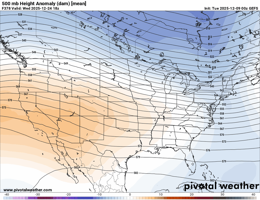
Yeah, but now we’re within range, so let’s get ready for the torch. Boxing Day =
-
2025-2026 ENSO
TheClimateChanger replied to 40/70 Benchmark's topic in Weather Forecasting and Discussion
They'll be okay. They got the kids glove treatment by the Committee. -

Winter 2025-26 Medium/Long Range Discussion
A-L-E-K replied to michsnowfreak's topic in Lakes/Ohio Valley
sure why not^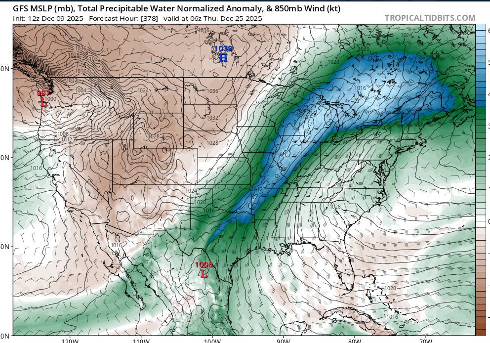
-
I wonder how much the op run is influencing this. The last 3 GEFS runs for Xmas eve.
-
Winter 2025-26 Medium/Long Range Discussion
TheClimateChanger replied to michsnowfreak's topic in Lakes/Ohio Valley
I wouldn't completely rule it out at this point. -

December 2025 Short/Medium Range Forecast Thread
Matthew70 replied to John1122's topic in Tennessee Valley
December is still below normal temps wise & looks to average close to normal for the rest of December. Much better than 70’s at Christmas. -

Pittsburgh/Western PA WINTER ‘25/‘26
RitualOfTheTrout replied to Burghblizz's topic in Upstate New York/Pennsylvania
Afternoon update from the NWS agrees. Tomorrow could be an interesting day if we manage to stay a few degrees cooler. Where the most tricky part of the forecast comes in is actually for the lower elevations of eastern OH and southwestern PA. 12z CAMs have taken on a slightly colder solution as the shield of precip arrives before sunrise and an enhanced push in the mid-morning hours. Forecast soundings show a very deep saturated layer well through and above the DGZ with strong synoptic forcing. Most of the entire profile is below freezing save the lowest few hundred feet where surface temperatures sit a degree or two above freezing. Should this be the case, a wet and cold rain will be the result. However, if surface temps are slightly overdone by the CAMs and/or dynamics cool the profile further than advertised, there is a conditional threat for a thump of heavy, wet snow to impact a good portion of southwest Pennsylvania, eastern Ohio, and the panhandle of West Virginia in the early morning to early afternoon hours. This may be a situation in which we have to see the whites of its eyes in the morning before knowing how it exactly will play out, but the worst case scenario could be a couple inches of accumulation with impacts to the morning commute. Finally, by the afternoon hours, a transition to convective snow showers with continued upslope in the ridges is likely as the stronger synoptic forcing moves east. Profiles suggest sufficient saturation through the DGZ remaining with steepening lapse rates in a low-level cold advection regime. Localized snow bands could produce another burst of accumulation and visibility reduction for the afternoon commute. Beyond the precipitation, tight surface gradients will foster gusty wind between 30-40 mph in the afternoon in the lower elevations, with 40-50 mph gusts possible in the ridges and peak gusts as high as 60 mph possible in the highest ridges of eastern Tucker County, WV. -

December 2025 Short/Medium Range Forecast Thread
AMZ8990 replied to John1122's topic in Tennessee Valley
December is always a tough month for snow and below average temps, so I tend not to worry about the forecast too much at this point despite how disheartening it may be. Peak climatology is still ahead of us, so we have that in our favor. -
Good lord, 12z GFS pops a 591 dm ridge over us on Christmas Day. Pain.


