All Activity
- Past hour
-
Low of 36. No second freeze
-
I’ll text my kid. She’s at ODU. If she saw snow she’ll tell me
-

November 2025 general discussions and probable topic derailings ...
dendrite replied to Typhoon Tip's topic in New England
The past 2 bigger events have been nice and visible to the naked eye here, but 2003 blows this away. It’s like comparing my 34” in 12hrs in Dec 2020 to my 34 flakes yesterday. -
BWI: 18.5 DCA: 12.0 IAD: 19.0 RIC: 10.5 Tie Breaker SBY: 8.0
-
Sharp rise in momentum starting to percolate into the circulation. Good stuff.
-
-
the Pacific jet is going to retract and shift equatorward after its poleward extension next week, which should lead to the -EPO that we're waiting for. I have pretty high confidence in this -EPO developing; the progression makes sense. BN to much BN temps in the East would follow into early Dec trough near Japan/HI are also old-school signs of a favorable Pacific pattern
.thumb.gif.d7f861d028ded8b36b10020c4783222d.gif)
.thumb.gif.eb5cfde7668d4682e6cc15a8a548d697.gif)
-
the Pacific jet is going to retract and shift equatorward after its poleward extension next week, which should lead to the -EPO that we're waiting for. I have pretty high confidence in this -EPO developing; the progression makes sense. BN to much BN temps in the East would follow into early Dec trough near Japan/HI are also old-school signs of a favorable Pacific pattern
.thumb.gif.349a25a1ecb9ea49c9a8a94a0b313f3e.gif)
.thumb.gif.b112d0bfadbc5ed5b791ef738ad58be0.gif)
-
the Pacific jet is going to retract and shift equatorward after its poleward extension next week, which should lead to the -EPO that we're waiting for. I have pretty high confidence in this -EPO developing; the progression makes sense. BN to much BN temps in the East would follow into early Dec trough near Japan/HI are also old-school signs of a favorable Pacific pattern
.thumb.gif.300bf27aab3d377118a7e5f0883262b9.gif)
.thumb.gif.c87f8ae27a7f07beecdbf4d05f888eea.gif)
-

2025-2026 ENSO
brooklynwx99 replied to 40/70 Benchmark's topic in Weather Forecasting and Discussion
the Pacific jet is going to retract and shift equatorward after its poleward extension next week, which should lead to the -EPO that we're waiting for. I have pretty high confidence in this -EPO developing; the progression makes sense. BN to much BN temps in the East would follow into early Dec trough near Japan/HI are also old-school signs of a favorable Pacific pattern.thumb.gif.bd50d08dbaeadf732dd38220f25673d6.gif)
.thumb.gif.2afbd364b1a76da6e6f6c00442c7165b.gif)
-
2025-2026 ENSO
brooklynwx99 replied to 40/70 Benchmark's topic in Weather Forecasting and Discussion
yeah, you have +PNA the day of but -PNA beforehand. the +PNA is a transient response to the low heights off the WC. retrograding -NAO is a must (which is why i hate when people totally downplay the impact of the NAO) -
So wait…. Was it visible to naked eye? Better or worse than May? Worth monitoring throughout the day?
-
Here’s hoping tonight is good?
-
My house here in Erwin!
-
Alot of clippers and possibly Miller B storms this winter.
-
Where is this,cool pic anyways?Looks so surreal,awesome
-
https://x.com/ryanhallyall/status/1988365006270771297?s=61 https://x.com/juliecar94/status/1988411163311534385?s=61
-

2025-2026 ENSO
donsutherland1 replied to 40/70 Benchmark's topic in Weather Forecasting and Discussion
For Washington, DC to New York City, a PNA+ is far more common for days with 6" or more snowfall except during the second half of February and afterward when the wave lengths shorten. New York City statistics since 1950: For January, when wave lengths are at their longest, a PNA+ was present for 92.5% of days with 6" or more snowfall in New York City. For Boston, the PNA+ plays a smaller role.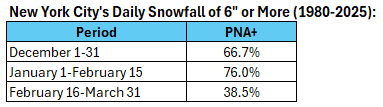
-
Norfolk reported 0.2” of snow officially yesterday??
-

2025-2026 ENSO
so_whats_happening replied to 40/70 Benchmark's topic in Weather Forecasting and Discussion
Lol parade of storms you would be lucky to get one maybe two good KU style storms in a season during the performative Nino style years. My goal this year is one 1 foot snowstorm and move on. Who knew that La Ninas produced quite the rains starting to show up for central and southern California in the medium range. -
Stronger CME should hit today sometime. So have to see how timing works out with darkness and cloud cover.
-
 I have only ever seen Aurora twice before. Once back in the late 1980s but I was in a city and it was meh. Then last October and it was all red but I was in a great spot Last night I could see the greens and reds with my naked eye pretty well. Camera brightens it a bit but still it was quite visible.
 -
Yeah. Neighbor’s porch lights
-

November 2025 general discussions and probable topic derailings ...
TheMainer replied to Typhoon Tip's topic in New England
First inch of snow overnight, only had flurries before. Going to move up driving our field stakes for the snowmobile club by a week cause if we wait the ground is going to be frozen pretty good. First fall since 2018 we won't do it the weekend before Thanksgiving so by pure anecdotal evidence hopefully we'll have a good winter! I'm skeptical about Sunday at lower elevation here in the valley, but up higher might do decent. - Today
-
I had various periods of flurries and snow showers during the day. The squall that came through around lunch time dropped visibility to 1/4 mile and left .2 on the board.


.gif.3a52c3ee1a50926d7f455e3fc3027abd.gif)
.gif.9871e77e4460e78583a160b4eba8e64a.gif)

.gif.6b1dacc47d1fc462c1b2a4cfe3c3dc61.gif)
.gif.6678967f5c12b17896db517411b3db51.gif)
.gif.9348eb99d2a5f12ea11f0280a53451fc.gif)
.gif.fd9c734ac479953fc07d12c972859802.gif)
.gif.92ef5ea1b6f6bd2fd088d7a75e775dba.gif)
.gif.c6237fb3e01a4f0ecdf9d0861ae5c46d.gif)


