All Activity
- Past hour
-
As forecast, the snow levels with this most recent storm began to drop yesterday evening, and the higher elevations picked up some decent snow accumulations by morning. The views from Bolton’s Base Lodge Webcam seemed to suggest just an inch or two of accumulation at 2,000’, and their Vista Summit Webcam was covered in snow, but the Allyn’s Lodge Snow Stake Cam at Sugarbush suggested that there were some decent accumulations around 3,000’. So, I decided to head up to Bolton Valley to at least get in a hike in the snow and check out the actual accumulations in person. The snow levels with this storm definitely didn’t make it down to the lower valleys, and even the local 2,000’ peaks surrounding the Winooski Valley in this area didn’t seem to have any visible accumulations. Those observations left me wondering just how high the snow levels had been, but it was clear as I ascended the Bolton Valley Access Road that the spine of the Greens had done better than some of the other surrounding areas. On my ascent toward Bolton Valley, I saw the first traces of snow around 1,200’, and up at the main base at 2,000’, accumulations were definitely more substantial than what the webcam had suggested. There was plenty of wind with this storm, and while exposed areas may have only accumulated an inch or two of snow, areas out of the wind held 3 to 4 inches of dense coverage. I started hiking the Wilderness Uphill Route with my skis on my pack, but within a couple of minutes I pulled out my skins and started skinning. It was clear that there was more than enough coverage to be skinning instead of walking if you wanted to, and there was a skin track in place as well. Accumulations increased all the way up to near the 3,000’ elevation range, but much like what the Sugarbush webcams had shown, where the 3,125’ stake had 5 inches of snow and the 3,900’ stake showed less than an inch of snow, accumulations sort of fell off as you hit the ridgelines above 3,000’. It must have been those winds – they really pounded and scoured the upper elevations relative to those middle elevations. Here's the snow accumulations profile I observed today in the Bolton Valley area during my tour in the midday period: 1,000’: 0” 1,200: T” 1,500’: T-1” 2,000’: 1-4” 2,500’: 4-6” 3,000’: 7-11” The forecast today suggested that at above 2,000’ the temperature was never going to go above freezing, and I’d say that’s what I observed. The temperature at 2,000’ was right around freezing and the snow there was a bit denser and softer, then in the middle elevations it was denser and colder with some upside-down consistency, and them up around 3,000’ the temperatures were well below freezing and the snow was notably drier. It was still on the denser side, but it didn’t have that upside-down feeling of the middle elevations and turns were easier. When I finished my ski tour and got back to my car, I saw that I’d missed a call from my younger son, so I called him back and he said that he and his crew from UVM were just at the base of the access road on their way up. So, I hung out for a bit, met them when they arrived at the base, and gave them the beta on everything I’d found on my tour. They subsequently had quite a fun tour of their own based on the video footage I saw later when they swung by the house, so it was great to see that everyone had a safe outing, and they kicked off their ski season with style!


-
whiteface making snow! early start
-
Indeed – he was there getting pictures of his bike in the snow when I was checking the cam for accumulations this morning, so I had to grab a still with him in it. It’s such a great Vermont change of seasons vibe, and you can’t help but imagine him in that pose standing there going “Huh.” It’s so on point though – I literary changed out my bike rack for my ski rack on the car today before I headed up to the hill.

-
 How good is the cyclone rake? Every year I say I’m going to get something to deal with these leaves and I don’t.
 - Today
-

Texas 2025 Discussion/Observations
Powerball replied to Stx_Thunder's topic in Central/Western States
2025 will end up being the 4th warmest October record for DFW (2024 was the warmest). The last week or so really knocked down the average. -
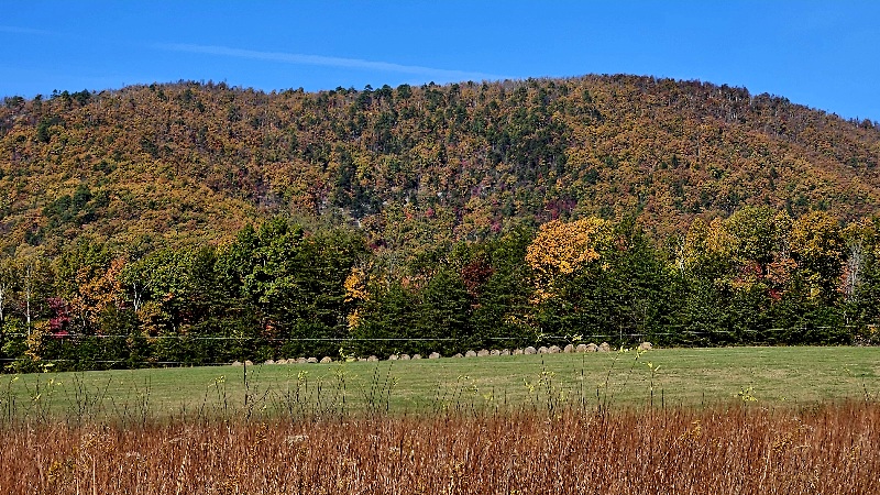
Fall scenery has been epic down here this year. Ready for snow now lol
.thumb.jpg.a331dc12fae42d50f83d96633688a053.jpg)
-
October total 2.53". 37.10" for 2025 so far. Lowest temp 35. Highest 79
-

November 2025 general discussions and probable topic derailings ...
alex replied to Typhoon Tip's topic in New England
We had some fatties in the early afternoon and some flurries tonight. Gotta go up towards the cog base station for any accumulation though -
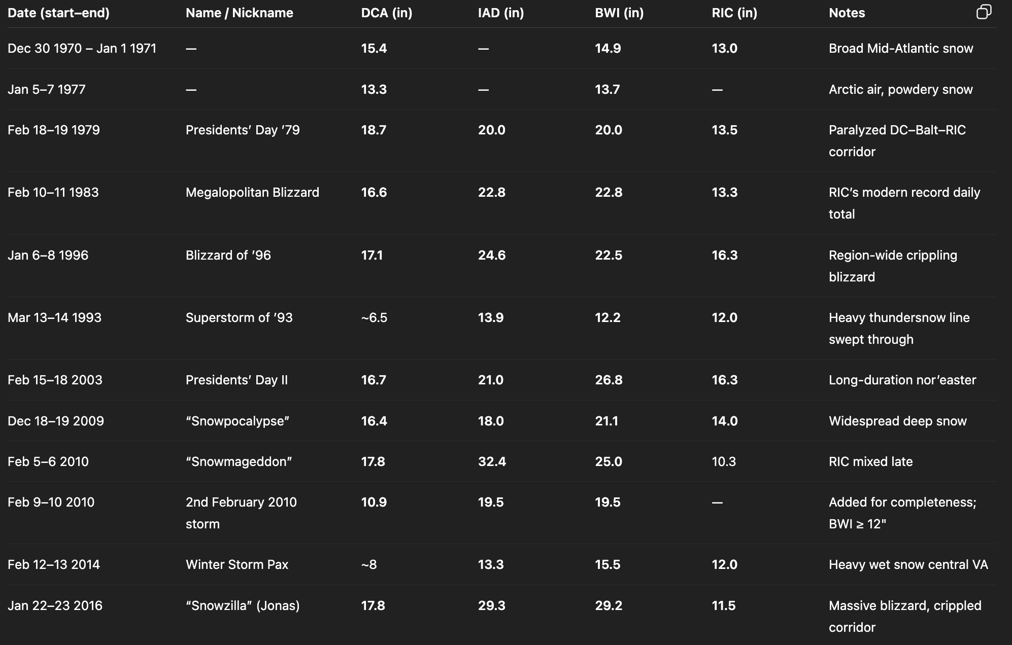
I asked ChatGPT to pull up a list of 12+" snowstorms at ANY of the airports (DCA, BWI, IAD, RIC) from 1970 to now. Apparently there was a 1 in 4.3 chance that you'd see a 12"er in a given season during then. So we are due, but apparently it's not astronomically rare—right now we're 1.66 standard deviations away from the mean, meaning there's about a 5-10% chance of a drought this long happening. For example, look at 1983-93 or 1993-2003.

-

November 2025 general discussions and probable topic derailings ...
SJonesWX replied to Typhoon Tip's topic in New England
That’s the plan tomorrow. blow ‘‘em into a few piles, suck ‘‘em up with the cyclone rake, then mow the rest of the lawn with the cyclone rake in tow. 2 2 acre yards should be done in <6 hours if all goes well. maybe find Time for a couple cold beers -

Spooky Season (October Disco Thread)
H2Otown_WX replied to Prismshine Productions's topic in New England
Just thank your lucky stars you're neurotypical -
 I really need to move up that way at some point ffs... Sent from my SM-S166V using Tapatalk
 -

Major Hurricane Melissa - 892mb - 185mph Jamaica landfall
Maestrobjwa replied to GaWx's topic in Tropical Headquarters
Yeah, unfortunately, it seems everything operationally is verifying on the ground. I am hopeful many lives were saved by residents heeding the advanced warnings. They had several days to plan. It will still be a miracle if the death count doesn't rise, however, despite the more densely populated areas in eastern Jamaica avoiding the eyewall. As you can see in the imagery, there are an overwhelming number of structures deroofed, walls down, or completely destroyed. Any major flooding reports from this? -
Happy Models Initiate at the Right Time of Day Eve! A day when many re-up their WxBell subscriptions… though I may way til a real threat now that lots of Euro stuff is free.
-

2025 Atlantic Hurricane Season
Windspeed replied to BarryStantonGBP's topic in Tropical Headquarters
https://tropical.atmos.colostate.edu/Realtime/ CSU TC-RAMS matches NOAA's.. The other site seems off as 34.7 is corrrect. -
Major Hurricane Melissa - 892mb - 185mph Jamaica landfall
Windspeed replied to GaWx's topic in Tropical Headquarters
Yeah, unfortunately, it seems everything operationally is verifying on the ground. I am hopeful many lives were saved by residents heeding the advanced warnings. They had several days to plan. It will still be a miracle if the death count doesn't rise, however, despite the more densely populated areas in eastern Jamaica avoiding the eyewall. As you can see in the imagery, there are an overwhelming number of structures deroofed, walls down, or completely destroyed. -
Love this, the guy with the bike. That's the most Bolton Valley thing ever.
-

Major Hurricane Melissa - 892mb - 185mph Jamaica landfall
Normandy Ho replied to GaWx's topic in Tropical Headquarters
For sure the Montego Bay damage consistent with cat3 winds -
Major Hurricane Melissa - 892mb - 185mph Jamaica landfall
Windspeed replied to GaWx's topic in Tropical Headquarters
I expected the imagery to be sombering for the southern coast. But the amount of destruction on Jamaica's NW coast, Montego Bay, etc., is pretty horrible. Clearly, Melissa's eyewall remained intense all the way across the island. -
Major Hurricane Melissa - 892mb - 185mph Jamaica landfall
Windspeed replied to GaWx's topic in Tropical Headquarters
The url on extwitter only showed the damage around those coordinates. Here's the main site you can use to zoom through what has been mapped so far. https://storms.ngs.noaa.gov/storms/melissa/index.html -

Fall 2025 Medium/Long Range Discussion
RogueWaves replied to Chicago Storm's topic in Lakes/Ohio Valley
Looking less snoozy up here and globals even throwing out random snow risks during this period. N stream so nothing heavy but at least it will look and feel more the season. -
BWI: 14.0 DCA: 9.5 IAD: 17.0 RIC: 10.0 SBY: 9.5
-
Yep. Lower than forecasted as usual.
-

2025-2026 Fall/Winter Mountain Thread
Daniel Boone replied to Buckethead's topic in Southeastern States
Yeah, all the lr(long range) Model's have Enso factored in very high. You can see La nina footprint. -
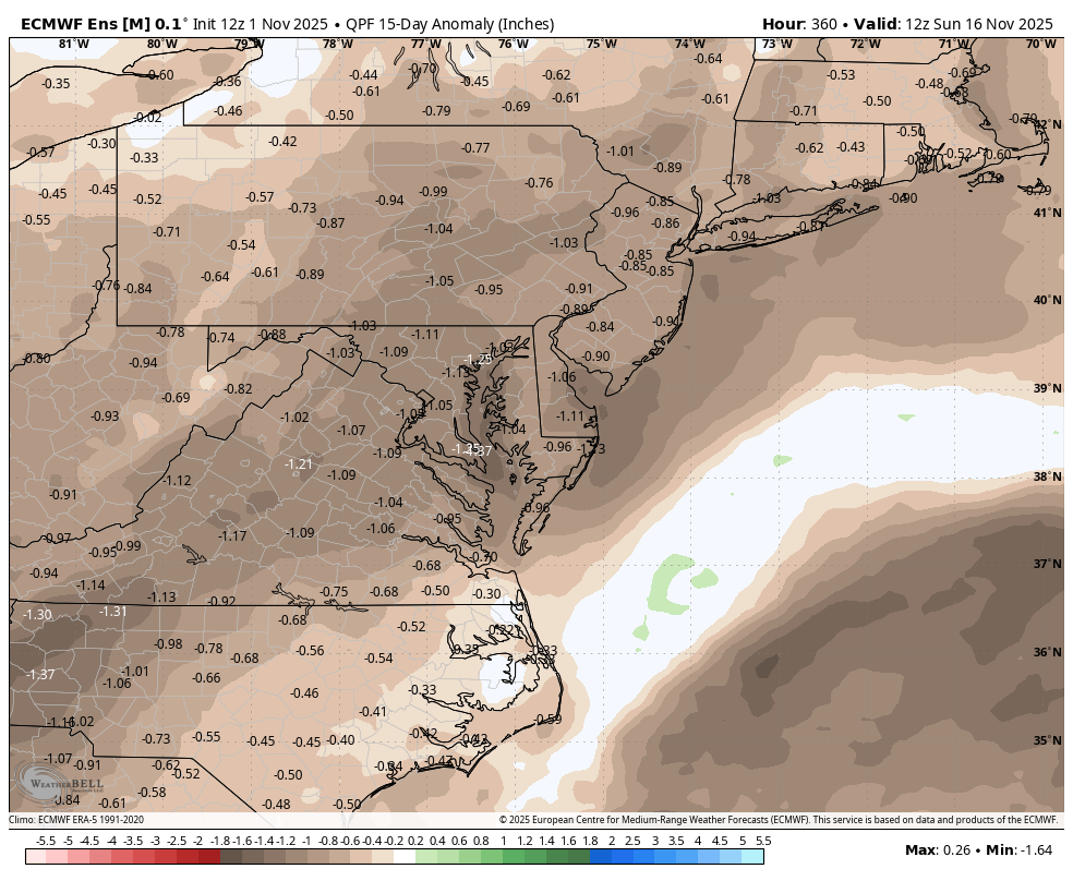
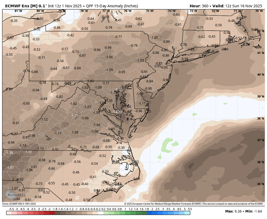
Latest EPS has a dry first half of November


.jpg.3781af55bf072c1a63d264e0cb298392.jpg)