All Activity
- Past hour
-
JUST missed a 'warm minimum' for the date. 68.7 low, record is 69 from 1986. Currently 71.1/68.9 at 8:10 am.
-
Yeah since June 20th or so we’ve had only a few breaks from the humidity. Hopefully it reverts to the mean with a below normal humidity August but it probably won’t
-
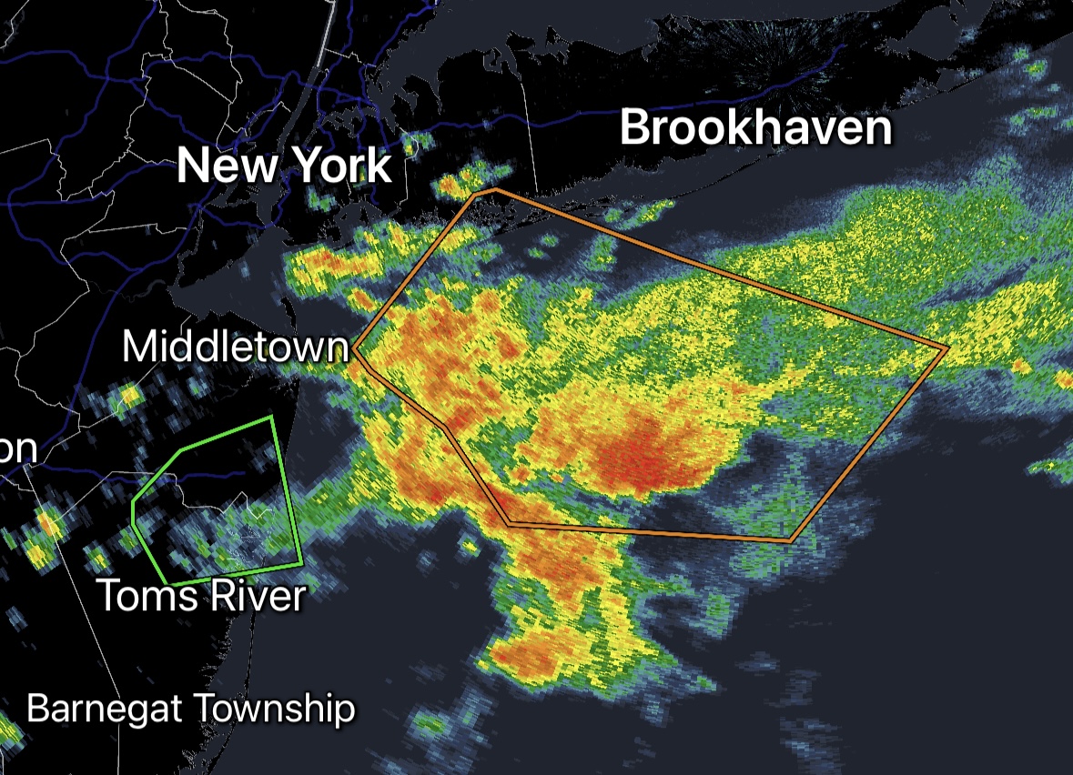
Really? There's a shower about 70 miles to your NW. That might be what you see. The furthest storm I've seen is about 120 miles. OC to Frederick is far.
-

July 2025 Discussion-OBS - seasonable summer variability
donsutherland1 replied to wdrag's topic in New York City Metro
Yesterday was yet another day that saw Central Park record the lowest high temperature among Bridgeport, Islip, JFK Airport, LaGuardia Airport, Newark, and White Plains. It was also the 11th time this summer. That is tied with the record for June 1-July 19 that was set in 2017. The summer record is 17 days during summers 2007 and 2017. -

2025-2026 ENSO
PhiEaglesfan712 replied to 40/70 Benchmark's topic in Weather Forecasting and Discussion
The 80s warming didn't really happen after the 1982-83 el nino. I feel it more happened after the 1986-88 event. Global temps in 1982 and 83 weren't much higher than 80 or 81. It didn't really didn't break through until 1988. We were still getting below 0 temps at PHL in January 1984 and January 1985. After the 86-88 el nino, below 0 temps only happened once at PHL (1/19/1994). -

July 2025 Obs/Disco ... possible historic month for heat
Damage In Tolland replied to Typhoon Tip's topic in New England
Can’t wait till the retorch / high dews get back Wed afternoon into the following week . Just get thru two ugly days early week and it’s all a dream -

July 2025 Obs/Disco ... possible historic month for heat
dendrite replied to Typhoon Tip's topic in New England
A little shot of summer yore Mon-Tue. It’s hard to imagine the majority of a summer being like that. -
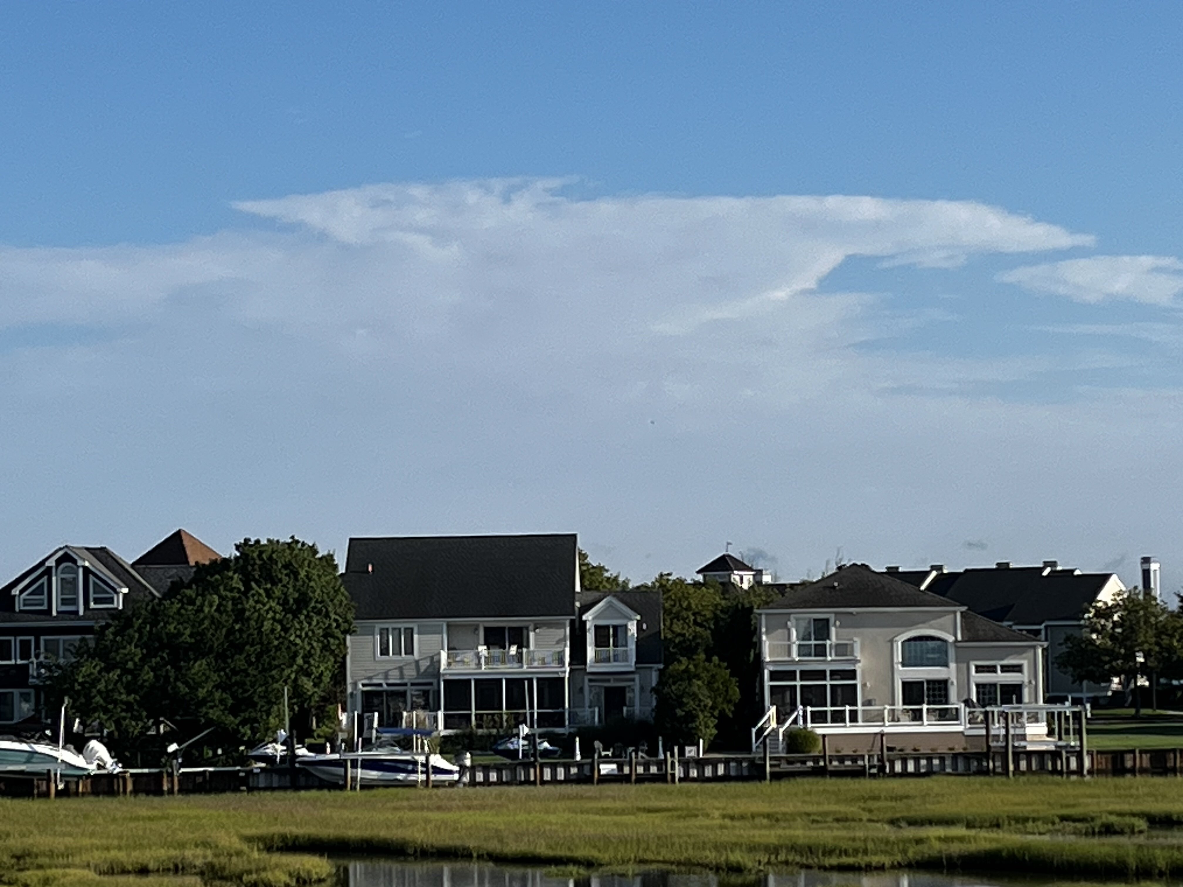
The anvil top of that storm in northern Frederick county as seen from OCMD
-

July 2025 Obs/Disco ... possible historic month for heat
powderfreak replied to Typhoon Tip's topic in New England
Yeah 61F here… that was fun for a day to feel what normal or below was like at night. - Today
-

July 2025 Obs/Disco ... possible historic month for heat
kdxken replied to Typhoon Tip's topic in New England
-

July 2025 Discussion-OBS - seasonable summer variability
bluewave replied to wdrag's topic in New York City Metro
Could be some waterspouts off the Long Island and Jersey Shore with rotation and SSTs near 80°. 15 E Barnegat Li 0930 78 78
-
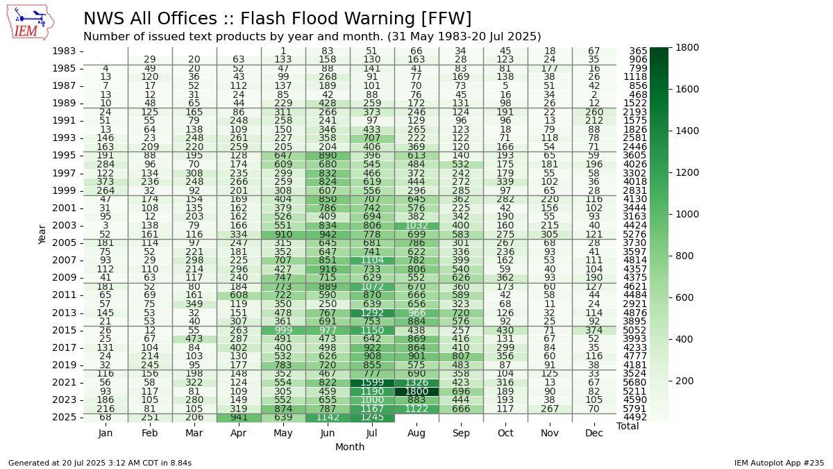
Flash flood warnings are on a record pace this year. Also trending higher with time.

-

July 2025 Discussion-OBS - seasonable summer variability
steve392 replied to wdrag's topic in New York City Metro
My long weekend at work. Nothing like staring at windows 30 feet up wondering what it's like outside lol 71 degree's and just insanely humid out. Like hitting a brick wall walking out the front door. -
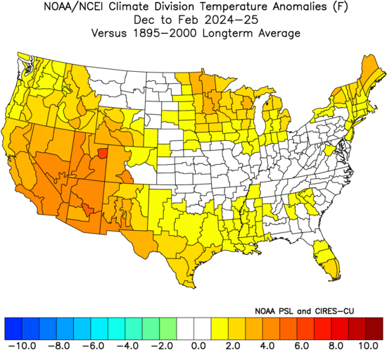
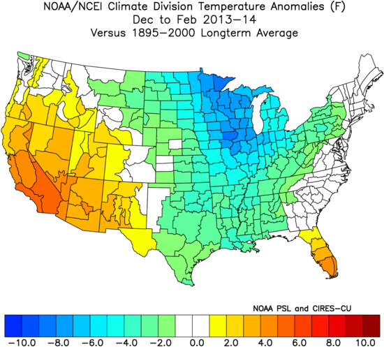
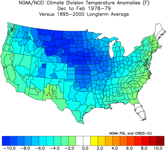
Last December was the 4th warmest on record for the CONUS. While January had decent pockets of cold especially for posters further south, it was only the 27th coldest January on record for the CONUS. Sure for the 2020s it was considered a colder month, but prior to this decade we had many much colder Januaries. Plus we warmed back up in February again. The 2024-2025 winter was among our colder winter for the 2020s so far. But against the long term average it actually ranked as the 27th warmest for the CONUS since 1895 at 34.07°. Right before the 2015-2016 global and regional temperature jump was our last top 40 coldest winter in 2013-2014 coming in at the 32nd coldest with an average temperature of 31.25° 2009-2010 came in even colder at 30.70° and 22nd coldest. This was the coldest winter after the baseline jump in temperatures in 1997-1998. Prior to this baseline jump the coldest winter was 1984-1985 at the 18th coldest with an average of 30.56° Our first baseline increase following the stable 1895 to 1982 climate regime with only a gentle warming occurred in 1982-1983. Prior to this our coldest winter was 1978-1979 ranked #1 coldest since 1895 at 26.62°. It was our last top 10 coldest winter in the CONUS. So we have seen a steady rise in CONUS winter temperatures following each successive baseline rise since 1982-1983. The magnitude of the baseline jumps has also been increasing since 2015-2016 and 2023-2024. This is why the current 10 winter period for the CONUS has been the warmest on record. So the impressive monthly Arctic outbreaks like during the 2020-2021 winters and 2018-2019 winters were more regionally focused instead of CONUS wide during earlier baseline periods. Even the January 2025 Arctic outbreak was more regionally focused. The most significant monthly cold anomaly was February 2021 ranking the 19th coldest February. But regionally it was more impressive focused into the Plains at the 9th coldest February. The winter overall wasn’t that cold due to how warm December and January were.

-

July 2025 Discussion-OBS - seasonable summer variability
Snowlover11 replied to wdrag's topic in New York City Metro
andddd new jersey wins again. -
Picked up 1.61” for a daily total of 1.82”which brings the monthly total to 8.55”
-
July 2025 Obs/Disco ... possible historic month for heat
dendrite replied to Typhoon Tip's topic in New England
Min 63.6° Mostly ovc but there’s a clearing line moving in from the NW. Let’s get some rain today. -
70s and best climo on tap for today
-
July 2025 Obs/Disco ... possible historic month for heat
kdxken replied to Typhoon Tip's topic in New England
70° / 66° back in the soup. Just came back from Boston it was 74 on the car at thermometer almost the entire way. -

July 2025 Discussion-OBS - seasonable summer variability
LongBeachSurfFreak replied to wdrag's topic in New York City Metro
Central Jersey storm/ff hot spot does it again. Amazingly consistent year after year down there. Meanwhile just showers amounting to a few hundredths on the island. -
Very interesting post/research on why the subsurface is arguing that this is likely going to be a 2nd year “double dip” La Niña:
-

2025-2026 ENSO
Stormchaserchuck1 replied to 40/70 Benchmark's topic in Weather Forecasting and Discussion
Talking on the internet is an extension of yourself. I'd argue that it's actually more real because the reflection is staring right back at you. With time, you start to communicate better. I know my posting has changed a lot from when I was young to now.. I didn't know completely how it would be perceived back then. In face-to-face talk it's very spontaneous. -
Yes, it’s a fairly new station.
-

Summer 2025 Medium/Long Range Discussion
MNstorms replied to Chicago Storm's topic in Lakes/Ohio Valley
Dew points in recent years peak 80F+ in July in Minnesota. -

2025-2026 ENSO
40/70 Benchmark replied to 40/70 Benchmark's topic in Weather Forecasting and Discussion
It's just easier to dehumanize someone when you don't look them in their eyes....you respond to a post and lose sight of the fact that there is a person on the other end of the the keyboard....samy dynamic with road rage....people dehumanize the other driver and flip.