All Activity
- Past hour
-
I ended up with .25. The rain today looks like it's being stubbornly north in Kentucky.
-
Was waiting for your comment on this! Its intriguing for sure.
-
To the three people who aren’t already aware, 73rd anniversary of the Worcester Tornado today
-
Thursday is an interesting day. I think the best instability probably rides into New York State and New Jersey possibly into western southern New England, but there’s an EML that’s gonna be trying to move in and Northwest flow aloft. Some of the soundings looked pretty impressive, especially on the nam yesterday. That’s a day to watch especially in western areas.
-

Central PA Summer 2026 Discussion/Obs Thread
mahantango#1 replied to Voyager's topic in Upstate New York/Pennsylvania
I seen yesterday there were 6 tornados confirmed by NWS in western Pa. US National Weather Service Pittsburgh PA · Follow · Just a quick update: so far, a total of six tornadoes have been confirmed in SW Pennsylvania from the Saturday storms: three in Washington County, two in Fayette County, and one in Westmoreland County. Additional details forthcoming both this evening and tomorrow. -
At least we got a deep summer stretch right on into about Monday or so.
-
Yeah next week is a little cooler here for sure. It looked like the trough axis would set up over the Great Lakes but it’s sort of setting up in southeast Canada so we’ll have more of a infiltration of cooler and drier air, although I don’t think it’s gonna be really below normal unless that low on the euro is correct.
-
promising look, nice that we should see multiple rounds impact klot
-
KFOK 45 so your number is impressive. .
-
Let's start a GoFundMe to tear down the Appalachians
-
Min 48.8°…sucks but it’s still early June. Still looks cooler next week…maybe more like mild downs in SNE. EC tries to sneak a low under NNE which would make for a mank day. Keep the mean trough in the midwest and we’ll be okay most days.
-
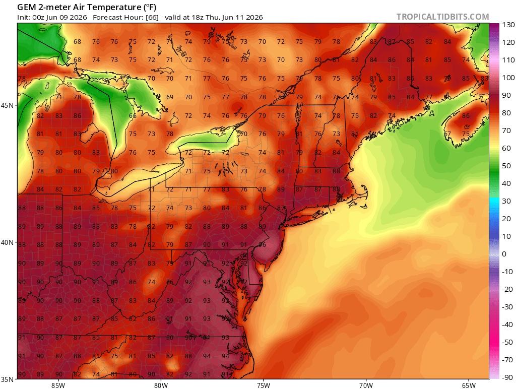
Hopefully, the clouds and convection can prevent another run on 100° so soon after the one in May. The only model with upper 90s in our area is the Euro. But it has less clouds and convection than the other models. It could be correct if the convection underperforms with the ongoing drought. The model forecasts highlight the big temperature divide as early as Thursday.

- Today
-

2026-2027 Super El Nino
bluewave replied to Stormchaserchuck1's topic in Weather Forecasting and Discussion
Ultimately El Niños are ranked by their jump in global temperatures. 2023-2024 had a larger rise in global temperatures than previous super El Niño events. So relying on the RONI metric is inadequate to describe these much stronger events. Even the authors of the paper which RONI is based on said the scale may need to be reevaluated in the future. So I view it as an experimental index which should be used alongside the traditional ONI scale. It can be used for assessing features like El Niño rainfall and the strength of the Aleutian Low. But ONI was closer to reality on temperatures during 2023-2024 than RONI. Plus the 500 mb ridge over North America was more in line with ONI. 2023-2024 was the warmest winter on record for the CONUS which none of the models beyond 15 days forecast. The warmth across the Northern Tier even exceed some of the previous super El Niño events. Seasonal models don’t have the ability to see extremes. Extreme warmth has been greatly exceeding extreme cold. So the long range models miss extreme warmth much more often since extreme cold has become so rare. About the only thing I use the seasonal models for are the Nino plumes once we get past the spring predictability barrier in early June. But we knew something really big was coming months ago with the record WWBs and kelvin waves. https://journals.ametsoc.org/view/journals/clim/37/4/JCLI-D-23-0406.1.xml As they previously cautioned, in the future, if there are significant divergences between the tropical mean state and trends in the Niño indices, then this index will need to be re-evaluated. We hope this work motivates additional studies and simulations of these indices in a changing climate. -
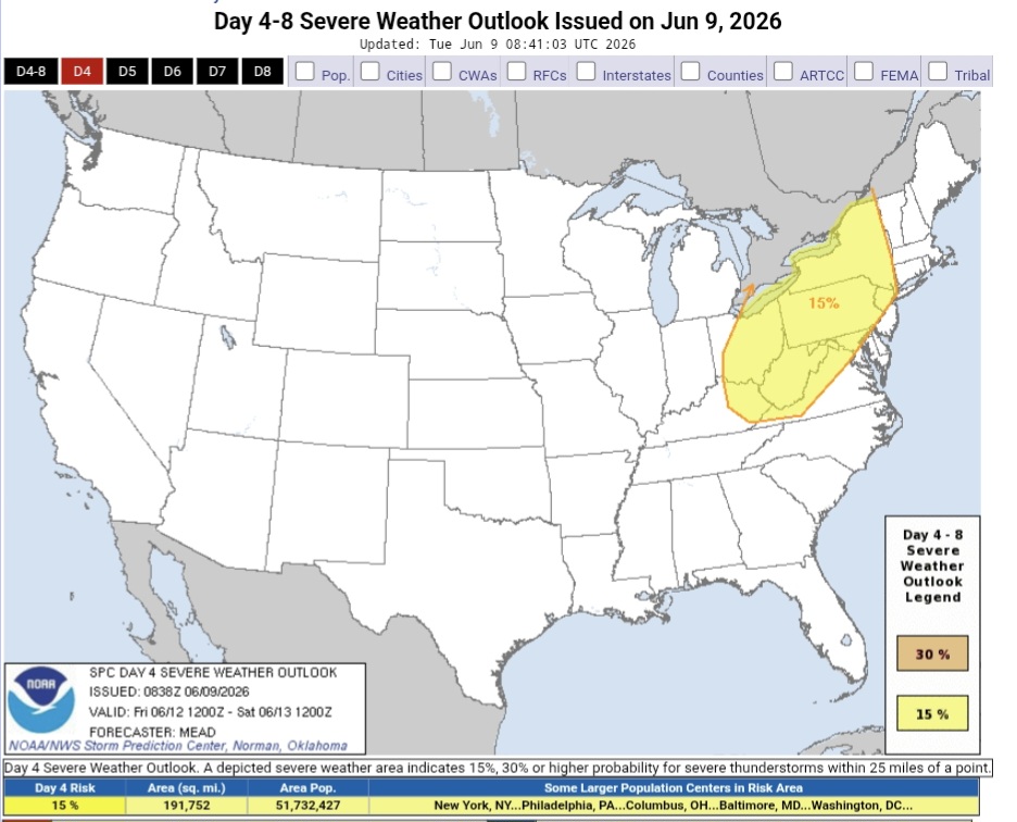
Day 2 marginal, Day 3 marginal and day 4 15%
- 441 replies
-
- 2
-

-
- severe
- thunderstorms
- (and 7 more)
-

Central PA Summer 2026 Discussion/Obs Thread
pawatch replied to Voyager's topic in Upstate New York/Pennsylvania
53 degrees this morning. Certainly a nice cloudy day yesterday.I wasn’t expecting that. High of 75 degrees. -
Central PA Summer 2026 Discussion/Obs Thread
mahantango#1 replied to Voyager's topic in Upstate New York/Pennsylvania
US National Weather Service State College PA Favorites · · HOT, HUMID, AND STORMY Increasing heat and humidity will be accompanied by daily chances for afternoon showers/thunderstorms through Friday. A classic summer-like pattern.. -
50.5F for my low lets see what happens in a week.
-

2026-2027 Super El Nino
snowman19 replied to Stormchaserchuck1's topic in Weather Forecasting and Discussion
The new DWKW has already started: And wow! 3 TC’s have formed in less than a week in the EPAC. Historic TC season coming up there -
41 this morning so far. Might crack below 40.
-
.thumb.jpg.6a4895b2a43f87359e4e7d04a6fa0d14.jpg)
Central PA Summer 2026 Discussion/Obs Thread
Yardstickgozinya replied to Voyager's topic in Upstate New York/Pennsylvania
ZCZC SPCSWOD48 ALL ACUS48 KWNS 090838 SPC AC 090838 Day 4-8 Convective Outlook NWS Storm Prediction Center Norman OK 0338 AM CDT Tue Jun 09 2026 Valid 121200Z - 171200Z ...DISCUSSION... ...Day 4/Friday... The last several deterministic model runs have consistently shown the progression of a short-wave trough and associated 50 kt jet streak from the OH Valley into the St. Lawrence Valley, with meaningful height falls as far south as the Mid-Atlantic. At the surface, the northern portion of a cold front initially from southwest Ontario to near the confluence of the MS and OH Rivers and into the southern Plains will progress southeast and eventually merge with a trough stretching from southern New England to the Carolina Piedmont. Ahead of the front, boundary-layer dewpoints in the 60s to low/mid 70s will combine with modestly steep mid-level lapse rates, especially across the lower Great lakes, to yield a moderately unstable air mass by afternoon. Initial storms are anticipated across the lower Great Lakes into upper OH Valley by early afternoon, with activity advancing east toward the Hudson Valley, and southeast into the central Appalachians and Mid-Atlantic through the remainder of the afternoon into evening. The strongest vertical shear is forecast from the lower OH Valley to the lee of the lower Great Lakes, where organized storm modes capable of damaging winds and large hail appear most probable. Elsewhere, a more isolated severe-weather threat may materialize within a low-level upslope regime in eastern NM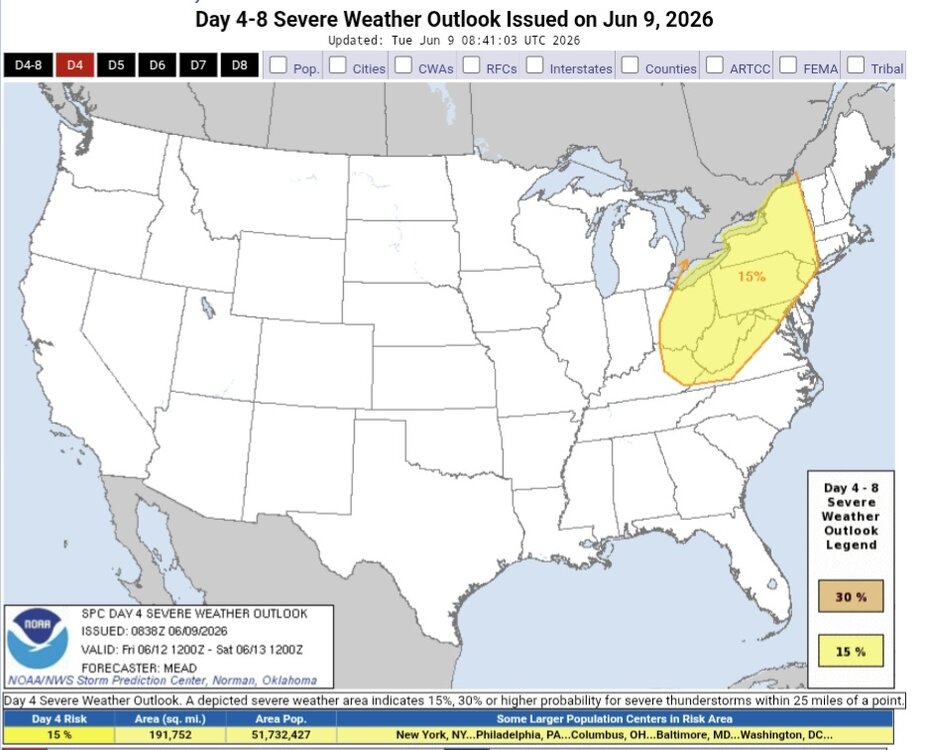
-
Nice natural AC, down to 49F
-
Looks like it's real. Another report out of the same area at 111 MPH with debarked trees.
-
See attachment for PDS bliz and ice storms. Goes into effect 10/1/26. I thought the NWS was trying to *reduce* the number of types of watch/warning products b/c there were too many. For instance, Blizzard Watch was removed several years ago. I am not a fan of PDS b/c it diminishes those events not labeled such that can be just as impactful. It's like Tornado Emergency. First, all tornadoes are emergency situations that require immediate action. Second, hearing "only" a tornado warning can be perceived as not as urgent to many. So a PDS blizzard or ice storm, same thing. And what exactly constitutes a PDS really? It is not always due to the meteorological severity or hard numbers. If a large population is impacted, does that mean a PDS is warranted. It's like saying a smaller population is less important than a larger one. Meteorological intensity and impact are two different things and not necessary correlated. I can just see PDS being overused from factors that have nothing to w/ the wx event itself. And it gives an excuse for the media and all the hype masters out there to ratchet things up even more, which promotes warning apathy further. The idea of PDS may look good on paper and in theory, but how it is handled in a practical sense in reality is an entirely different ballgame, and the way wx is handled these days in itself as if all inclement wx is "extreme," "unusual," and "not supposed to happen?" The ordinary is turned into the extraordinary far too often. What's next, a PDS for a hurricane landfall? Dense fog? Dust storm? More warning is not necessary better. There comes a point of diminishing returns. pds.pdf


.thumb.jpeg.f5c6ba9d911ec96b3b124f8606aee58e.jpeg)