All Activity
- Past hour
-
What limited research I've done on those winters shows they started with northwest flows and clippers laying down a good snowpack before bigger storms came in from the southwest. Would be epic to cash in on the same this season.
-
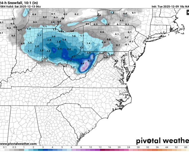
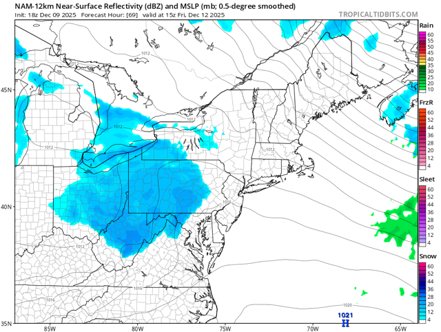
18z NAM 3km smokes the high elevations. As I said before this is also a good solution for getting those flakes into the valleys. 30mph winds and temps in the mid 20’s allow those flakes to push out much farther from the higher elevations.
-

December 2025 regional war/obs/disco thread
Ginx snewx replied to Torch Tiger's topic in New England
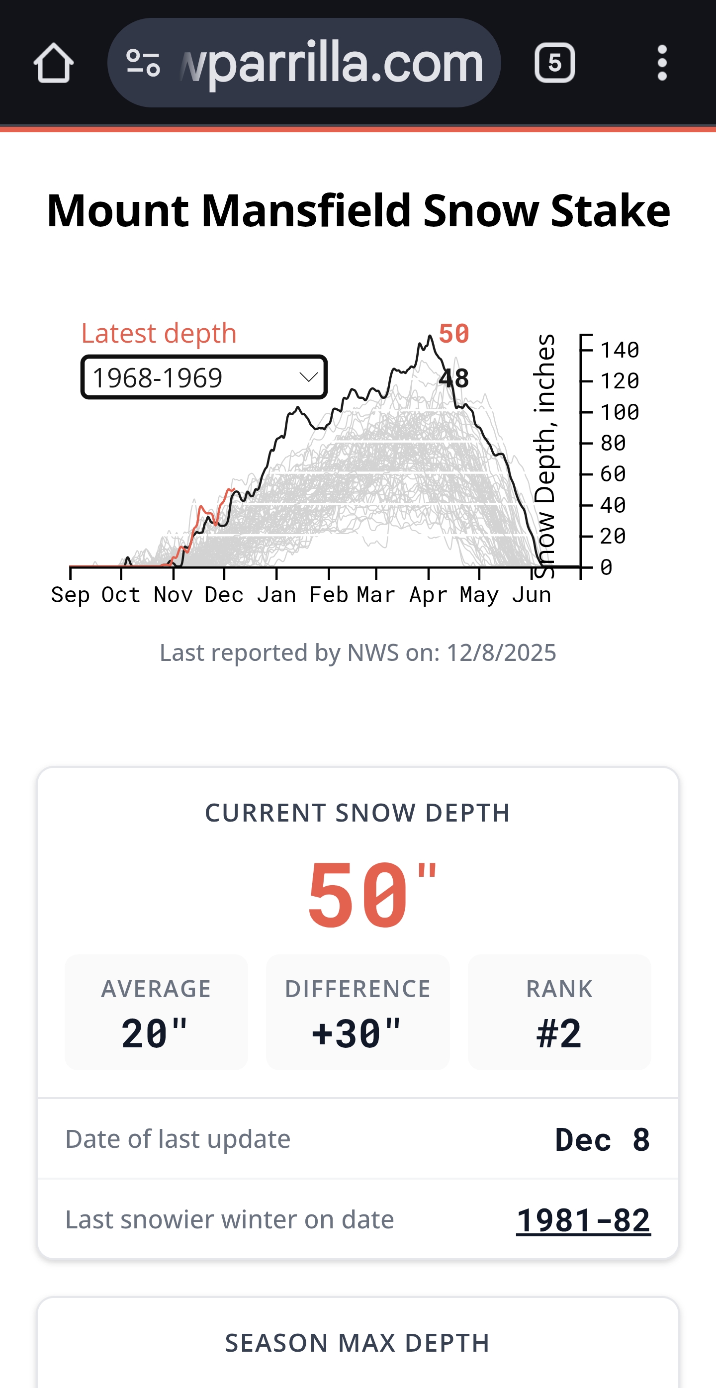
68/69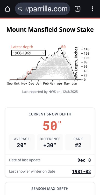
-

December 2025 regional war/obs/disco thread
WxWatcher007 replied to Torch Tiger's topic in New England
This place is a weenie insane asylum. My God. -

December 2025 regional war/obs/disco thread
moneypitmike replied to Torch Tiger's topic in New England
One is through Thursday am, the other friday am. -
That would suck. But not buying it
-
Probably the best start to winter in my 63 years. Probably not a close call either. And that includes the late ‘70’s
-

December 2025 regional war/obs/disco thread
Typhoon Tip replied to Torch Tiger's topic in New England
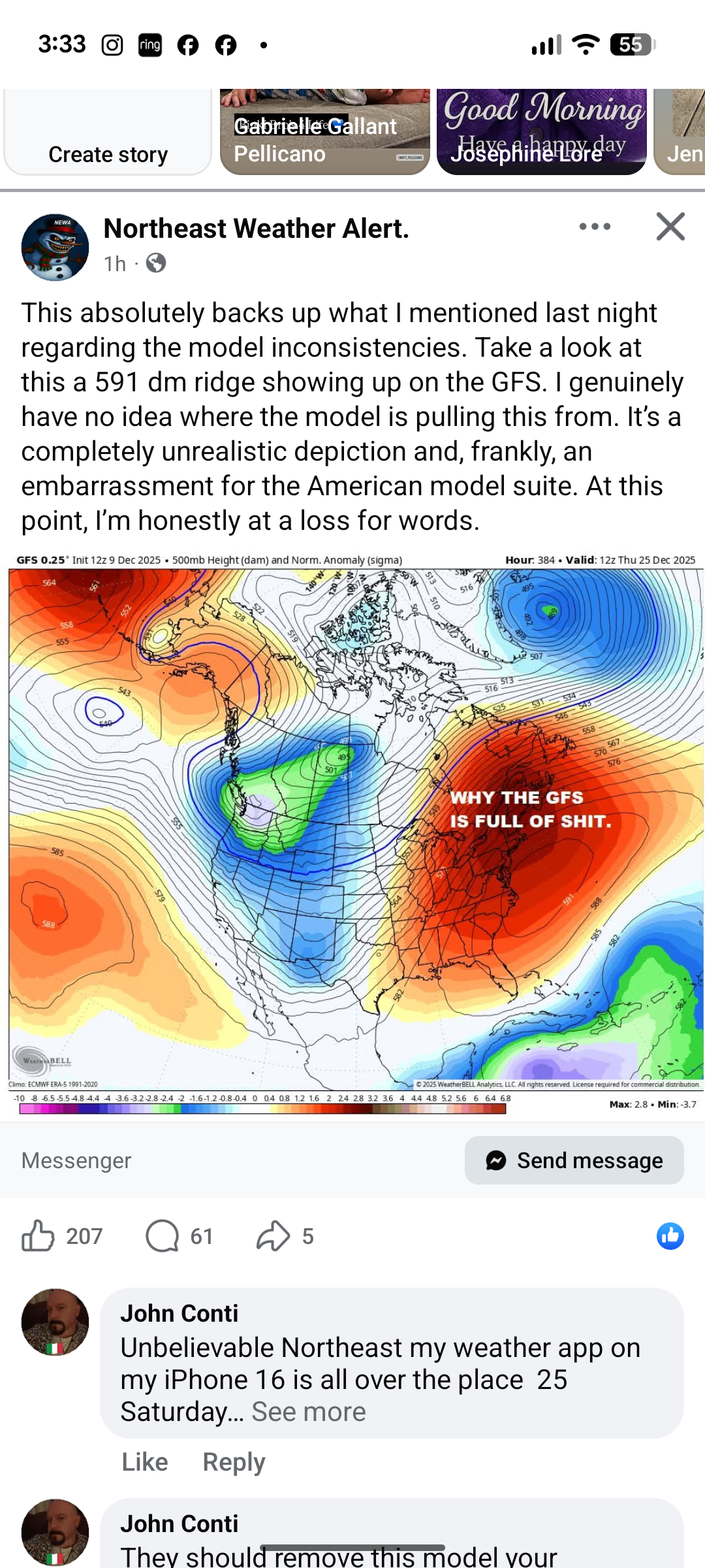
that post reeked of self-soothing ... It was really drafted up to off-set the fear they, themselves, covet. -
You’d think ok this looks good. Then next frame just evaporates.
-
Comes in looking good then just vaporizes
-
December 2025 regional war/obs/disco thread
Typhoon Tip replied to Torch Tiger's topic in New England
yeah anyway. you can't trust guidance beyond 90 or so hours in this maelstrom of a hemisphere. that goes for anything -

December 2025 regional war/obs/disco thread
WinterWolf replied to Torch Tiger's topic in New England
384 hrs out…but who’s counting. -
Winter Weather Advisory up. ...WINTER WEATHER ADVISORY IN EFFECT FROM 7 AM WEDNESDAY TO 1 AM EST THURSDAY... * WHAT...Snow expected. Total snow accumulations between 3 and 7 inches. * WHERE...Portions of central, northwest, and southern Vermont. * WHEN...From 7 AM Wednesday to 1 AM EST Thursday. * IMPACTS...Plan on slippery road conditions. The hazardous conditions will impact the Wednesday morning and evening commutes. * ADDITIONAL DETAILS...Heaviest snow is expected to occur between 10 AM and 3 PM Wednesday.
-

December 2025 regional war/obs/disco thread
Snowcrazed71 replied to Torch Tiger's topic in New England
I actually posted this for all those about to jump off a cliff. Just don't know why people drive themselves insane with things 2 weeks out. We can't even get things right. It's 5 days out LOL -

2025-2026 ENSO
vegan_edible replied to 40/70 Benchmark's topic in Weather Forecasting and Discussion
dont even stress it. bro doesnt have the computational output to look at an ensemble rather an op model -
December 2025 regional war/obs/disco thread
Typhoon Tip replied to Torch Tiger's topic in New England
Haha... How about, cuz'n it was 360+ hours out 'nough said? -
December 2025 regional war/obs/disco thread
Snowcrazed71 replied to Torch Tiger's topic in New England
I mentioned that I really like this guy. And he is calling bull$@& on the major warm up. But, we'll see
-

December 2025 regional war/obs/disco thread
weatherwiz replied to Torch Tiger's topic in New England
Well this is just an anomaly map...these colors don't necessarily mean "warm", especially this time of year. It's relative to climo. So for like NNE...its still going to be cold or chilly but a bit above of what it should be for the time of year. -

Winter 2025-26 Medium/Long Range Discussion
Baum replied to michsnowfreak's topic in Lakes/Ohio Valley
Not a big white Christmas guy if I’ve already put 20” on the ground by then. -
Nam pretty juicy west of us at hour 60, beefed up from 12z let’s see if it equals better here
-
December 2025 regional war/obs/disco thread
WinterWolf replied to Torch Tiger's topic in New England
I posted that too. -
It’s disheartening that long lasting pack-building patterns are getting more rare due to AGW. I don’t know if a 2013-2014 can happen again. It was already a fluke and we have warmed since then. Have to move north of 47 to hope for a deep snowpack.
-

Winter 2025-26 Short Range Discussion
A-L-E-K replied to SchaumburgStormer's topic in Lakes/Ohio Valley
going with a bullish 3" on the thursday night duster -
December 2025 regional war/obs/disco thread
Snowcrazed71 replied to Torch Tiger's topic in New England
Well... The first 9 days have been super cold, and if this does pan out, it looks like it would only pan out for less than a week. If that. This map looks kind of odd to me though. Having the whole continental United States and half of Eastern Canada this warm doesn't make any sense. It just doesn't look right to me, but what do I know. -

December 2025 regional war/obs/disco thread
40/70 Benchmark replied to Torch Tiger's topic in New England
I thought @CT Rain's video was reasonable....basically a compromise of the GEM and EURO solutions favored, which should yield some snow, but certainly no blockbuster.