All Activity
- Past hour
-

December 2025 regional war/obs/disco thread
Kitz Craver replied to Torch Tiger's topic in New England
Sure more cold around, but not much to show for it on last nights model runs. Either OTS underneath or keeps SNE right on the R/S edge. Not the greatest -

First Winter Storm to kickoff 2025-26 Winter season
CoastalWx replied to Baroclinic Zone's topic in New England
No chance -
Edibles? Check EPS
-

December 2025 Short/Medium Range Forecast Thread
Holston_River_Rambler replied to John1122's topic in Tennessee Valley
I created a Winter 25/26 general obs thread in case anyone sees some snow this AM @Knoxtron and @John1122 I'm staring at y'all with jealousy. -
Yep about the same here. We need the rain though
-
Overcast and 27/22 after a low of 19 here. We had a brief flurry around 7am but the real stuff is probably a couple hours away. My location will be uncomfortably close to the mixing line by late this afternoon but most guidance seems to keep it just a hair to my south. I'm just off exit 3 on I-93.
-

Central PA Fall Discussions and Obs
mahantango#1 replied to ChescoWx's topic in Upstate New York/Pennsylvania
Is it snowing in the 'burg? If it is and its laying. Haven't heard any reports yet, unless I missed 'em. -

Central PA Fall Discussions and Obs
Blizzard92 replied to ChescoWx's topic in Upstate New York/Pennsylvania
About 1 inch of snow so far near Linglestown, but watching the warm nose push toward the Harrisburg metro. -

December 2025 regional war/obs/disco thread
Ginx snewx replied to Torch Tiger's topic in New England
Beer?
-
When’s it gonna start. Patiently waiting
-
First Winter Storm to kickoff 2025-26 Winter season
CoastalWx replied to Baroclinic Zone's topic in New England
Scooter knows and knew all along -
Thought I would create a general obs thread for winter in case anyone sees some snow this AM and of course for the rest of the winter. @Knoxtron looks like some temps are between 34 and 36 down your way. Some radar returns down in. NE Alabama look snow-like: Wouldn't be surprised if you, or John, or one of our Cumberland county folks get a quick dusting.
-
Records: Highs: EWR: 66 (1998) NYC: 66 (1970) LGA: 66 (1970) JFK: 62 (1998) Lows: EWR: 16 (1946) NYC: 11 (1875) LGA: 17 (1976) JFK: 17 (1989) Historical: 1896 - An early season snow and ice storm struck the southeastern U.S. It produced 11 inches of snow at Charlotte NC, and six inches at Atlanta GA. (David Ludlum) 1925 - A late season hurricane caused extensive damage across the Florida peninsula, then moved off the Georgia coast crossing Cape Hatteras as a tropical storm. The storm produced whole gales along the Middle Atlantic and Southern New England coast. Winds gusted to 60 mph at Block Island RI, and reached 64 mph at Atlantic City NJ. (David Ludlum) 1940: The high temperature of 78 °F at Las Vegas, NV set the all-time warmest temperature in December. (Ref. Wilson Wx. History) 1942: Boston, Massachusetts recorded its lowest December pressure of 28.49 inches of mercury. (Ref. NOAA Boston Weather Events) 1950 - A late season tornado killed four persons in Madison County and Bond County, east of St Louis MO. Three tornadoes touched down in Illinois that afternoon, compared to just half a dozen tornadoes in the month of December in 115 years of records up until that time. Thunderstorms also produced hail which caused more than four million dollars damage in the St Louis area, it was the most damaging hailstorm of record for Missouri. (David Ludlum) (The Weather Channel) A tornado causing F2 damage moved through Madison and Macoupin counties in Illinois. One person was killed and 3 more were injured in a car that was carried 200 yards near Mt. Olive. (Ref. Wilson Wx. History) 1964: The first major snowstorm of the season covered parts of northwest Oklahoma with as much as 9 inches of snow through the 3rd. Most roads became snow packed and hazardous, which caused schools across the area to close for one to two days. Just south of the heavy snow area, freezing rain and sleet iced highways and bridges along a belt 100 miles wide, from southwest to northeast Oklahoma. Temperatures in the teens and 20s helped to maintain the snow cover for a week. (Ref. Wilson Wx. History) 1968: The "Sacramento," a 250-foot fishing barge and former ferry between San Francisco and Oakland, succumb to a winter storm off Redondo Beach. 1970 - A tornado, 400 yards in width, touched down about one mile below the summit of Timpanogos Divide. Trees up to 18 inches in diameter were snapped, and some of the 38 inch snow cover was carried 1000 feet above the ground as the tornado traveled one mile. (The Weather Channel) 1974: Big snows occurred across the lower Great Lakes and Ohio Valley. One of the more remarkable amounts was 19.5 inches at Detroit, MI. (Ref. AccWeather Weather History) 1977: High winds buffeted the Colorado Rockies. Wind gusts were clocked at 104 mph at Nederland, CO, 100 mph at Morrison, CO and 62 mph at Rocky Flats, CO. (Ref. Wilson Wx. History) 1982 - A tornado destroyed a home four miles south of Eastwood MO. The owners were not injured in that tornado, but ironically one was killed Christmas Eve when another tornado hit the replacement mobile home on the same site. (The Weather Channel) A tremendous rainstorm in central Illinois brought 6.12 inches of rain to Springfield during a 24 hour period through the 3rd. Jacksonville, IL had 4.80 inches and Peoria, IL recorded 2.89 inches during this period. Lake Springfield rose two feet over the old record stage, flooding nearby land. $100,000 dollars damage occurred to the dam at the lake, due to the tremendous flow of water.(Ref. Wilson Wx. History) The following locations recorded their warmest December temperature on record: Fort Wayne, IN: 71 °F (the only time Fort Wayne ever reached 70° in December), South Bend, IN: 71 °F, Goshen, IN: 69 °F, Elkader, IA: 65 °F, Genoa, WI: 65 °F, Prairie du Chien, WI: 65 °F, Alma, WI: 64 °F, Dodge, WI: 64 °F, Hillsboro, WI: 64 °F, Lynxville, WI: 64 °F, Neillsville, WI: 63 °F, Trempealeau, WI: 63 °F, Viroqua, WI: 63 °F, Caledonia, MN: 62 °F and Theilman, MN: 62 °F. (Ref. Wilson Wx. History) 1985: Richmond, Virginia had its latest freezing day of autumn on this date in 1985 when the temperature fell to 30 °F. The average first freezing day in autumn is October 29th. (1971 to 2000 average)(Ref. Richmond Weather Records KRIC) The significant snow storm from the previous day continued to effect the region, with snow totals including: Dorchester, IA: 18 inches (their greatest one-day snowfall), Hatfield, WI: 16 inches, Soldiers Grove, WI: 15 inches (their greatest one-day snowfall), Sparta, WI: 15 inches, Viroqua, WI: 15 inches (2.2 inches liquid equivalent, their wettest December day), Waukon, IA: 14 inches (their greatest one-day snowfall), La Crescent, MN: 13 inches, Preston, MN: 12.5 inches, Owen, WI: 11 inches (their greatest one-day snowfall, Dodge, WI: 11 inches, Goodrich, WI: 11 inches, Mather, WI: 10 inches, Fayette, IA: 8.5 inches. (Ref. Wilson Wx. History) 1987 - A powerful storm over the Gulf of Alaska continued to produced high winds and heavy rain along the northern and central Pacific coast. Winds gusted to 80 mph south of Port Orford OR, Stevens Pass WA was blanketed with sixteen inches of snow, and Blue Canyon CA was soaked with 1.63 inches of rain. (Storm Data) (The National Weather Summary) 1988 - Squalls in the Great Lakes Region produced ten inches of snow at Union City, PA. Gale force winds gusted to 55 mph at Buffalo NY. (The National Weather Summary) (Storm Data) 1989 - Squalls produced heavy snow in the Great Lakes Region. Totals in Upper Michigan ranged up to 20 inches at Ironwood. Heavy snow and high winds caused 150 auto accidents in Michigan, resulting in sixteen deaths and 22 injuries. Strong northwesterly winds gusted to 73 mph at Johnstown PA, and Lowville PA received 20 inches of snow in 36 hours. (The National Weather Summary) (Storm Data) 1999: Severe thunderstorms produced three tornadoes in central Oklahoma. Two tornadoes occurred in Logan County near Guthrie, and one tornado touched down near Perry, in Noble County. The tornadoes damaged trees, power poles, barns, outbuildings, and one of them unroofed homes near Guthrie. The December tornado event capped off a record year for tornadoes in Oklahoma, as 145 twisters were observed. (Ref. Wilson Wx. History) 2001: A strong winter storm dropped 50 inches of snow at Gin Flat, CA in 34 hours and 31 inches of snow at Big Flat, CA in 20 hours. Yosemite Valley, CA recorded 7 inches of snow in just 10 hours. (Ref. Wilson Wx. History) 2005: Over the east-central North Atlantic, Epsilon reached hurricane intensity with maximum sustained winds of 80 mph. Hurricane force winds persisted for five days. Epsilon is only the sixth December hurricane ever recorded in the Atlantic Basin. (Ref. Wilson Wx. History)
-

Central PA Fall Discussions and Obs
Mount Joy Snowman replied to ChescoWx's topic in Upstate New York/Pennsylvania
31 when degrees here and the warm nose has entered the conversation, as I’ve transitioned fully to sleet after a very brief period of snow. CC radar shows the line perfectly. Maybe .2” but happy for those that are making out. Hopefully not a harbinger of what’s to come down this way this winter ha. -
Yup 22.3F and a dusting of steady SN-
-
We arch.
-
The jack should be where the WAA portion of the storm is maximized, and the banding this afternoon overlaps the most. I think the deformation is gonna come in a bit NW of modeling, seems like the atmosphere has it’s preferred deform location across Central NH based off prior events (aka congrats Dendrite)
-
Sure enough, got 3”. Three day total of 13.9”. 10” snow depth.
-
Mid month torch to wipe it out before reset.
-

First Winter Storm to kickoff 2025-26 Winter season
moneypitmike replied to Baroclinic Zone's topic in New England
Snow is serious business, man. -
First Winter Storm to kickoff 2025-26 Winter season
Ginx snewx replied to Baroclinic Zone's topic in New England
Sardonic this am I see because no snow for you. Man up it sucks but its OK. Go to your safe space. -

Southern MD / Lower Eastern Shore weather discussion
SnowtoRain replied to PrinceFrederickWx's topic in Mid Atlantic
33.8, rain, 0.1, hopefully can get >.75" from the storm -
1/18/15: the last warm storm of the season. Started as ZR in NH (was was XC skiing in Jackson and it had been around 0 overnight, ZR started around 15, I came down a hill coated in ice; can't imagine it was much of a day at the downhill areas either), valley didn't scour out until mid-afternoon (I went skiing in the zr because it seemed preferable to driving in it) and eventually left once the temperature had gone above 32. The carnage on Route 16 was impressive, I saw the first spinout within the first mile, asked the trooper there if the roads were safe and he said "well, they're safe now." That was the last time it was above freezing up there for two months.
-
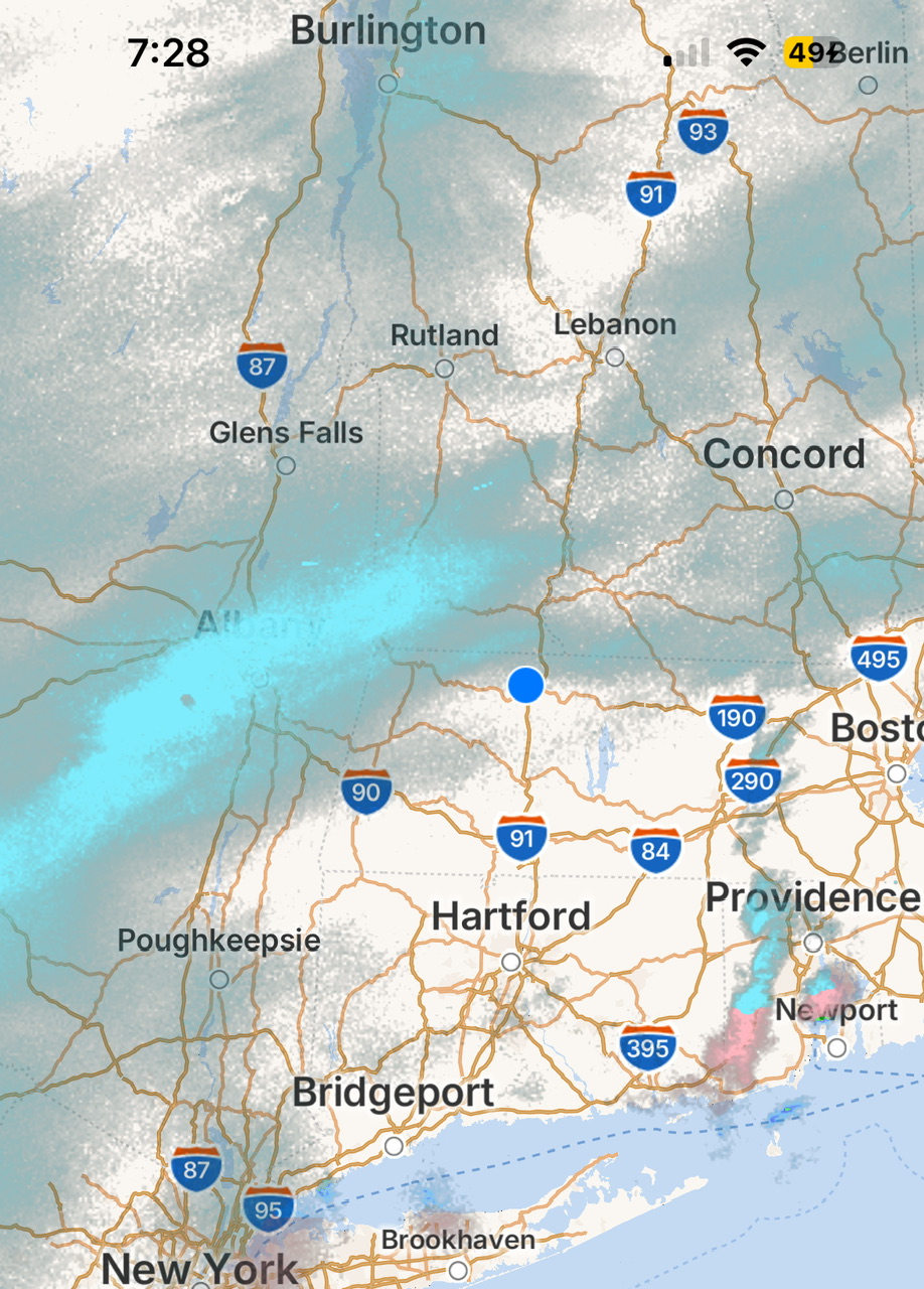
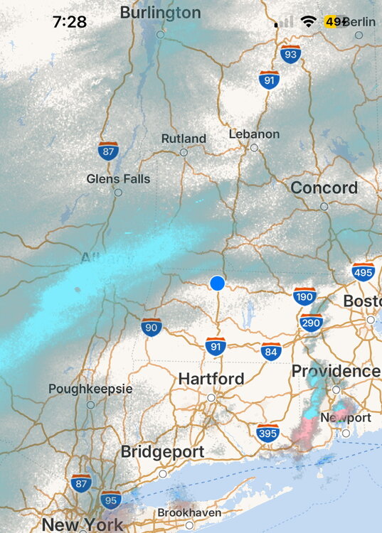
A number of the models were showing precipitation arching over the MA line into NH and Maine. Based on reports (not radar), that might be what's happening.
-
I am getting reports from both kids. The one in DC is not happy with her cold rain. Meanwhile the one up in Carlisle PA just found out her campus is closed today. And here in Frederick Co I just checked and FCPS MD is closed. My weather app says light freezing rain here. But I am sure up in the mountains it is more than that. ETA with no kids in FCPS anymore just found out the reason for no 2 hr delay was today is an early dismissal day. So would not have made sense to do a delay only to send the kids back home.


.thumb.png.4150b06c63a21f61052e47a612bf1818.png)