All Activity
- Past hour
-
BWI: 9.7" DCA: 5.0" IAD: 14.1" RIC: 2.2" (Tiebreaker) SBY: 0.6"
-
My current plan is to roll out before/during sunset and drive north. Hoping the traffic isn’t heinous. anything around a 12pm hit should be good… substorms lasted til like 4am for yesterday’s.
-
We never really dropped last night. 36.7 was lowest we got all night. It’s crazy out of a system that brought sub freezing temps to Florida, snow to the coast, and single digits to mountains we managed one night below freezing
-

E PA/NJ/DE Autumn 2025 Obs/Discussion
Mikeymac5306 replied to PhiEaglesfan712's topic in Philadelphia Region
Knew nothing about the Auora last night till my son mentioned it at 9:30. Amazing that it was that clear, and even more beautiful behind a lens. BTW welcome back all the snowbirds to the forum. Happy tracking. Let's have some fun. Don't take it too seriously. -
Set a new 'cool max' for the date of 37.8 degrees, beating (barely) the 39.0 from 2018 and 1996. Temps climbed here after midnight when it was in upper 20's to 37.4 degrees at 7 am. Although radar looked good last night for about an hour, nothing made it to the ground.
-
(002).thumb.png.6e3d9d46bca5fe41aab7a74871dd8af8.png)
Central PA Fall Discussions and Obs
ChescoWx replied to ChescoWx's topic in Upstate New York/Pennsylvania
Today should be almost 10 degrees warmer than yesterday...but still a few degrees below normal for mid-November with highs in the upper 40's to around 50 degrees. Temperatures look to stay near to below normal through Saturday before we briefly warm to above normal Sunday before falling back below normal to start the new work week. Our next rain chance looks to arrive Saturday night into Sunday.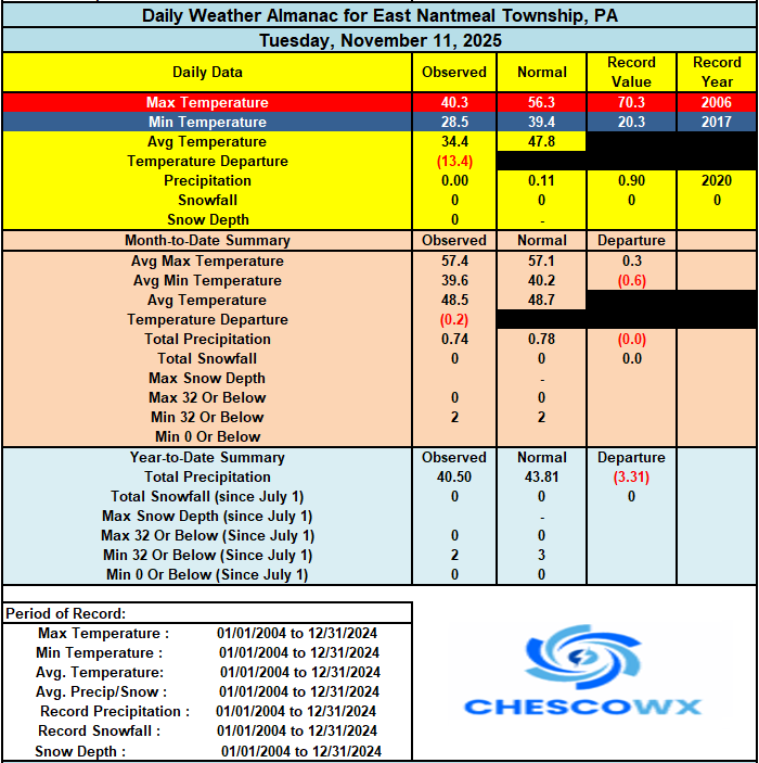
-
E PA/NJ/DE Autumn 2025 Obs/Discussion
ChescoWx replied to PhiEaglesfan712's topic in Philadelphia Region
Today should be almost 10 degrees warmer than yesterday...but still a few degrees below normal for mid-November with highs in the upper 40's to around 50 degrees. Temperatures look to stay near to below normal through Saturday before we briefly warm to above normal Sunday before falling back below normal to start the new work week. Our next rain chance looks to arrive Saturday night into Sunday.
-
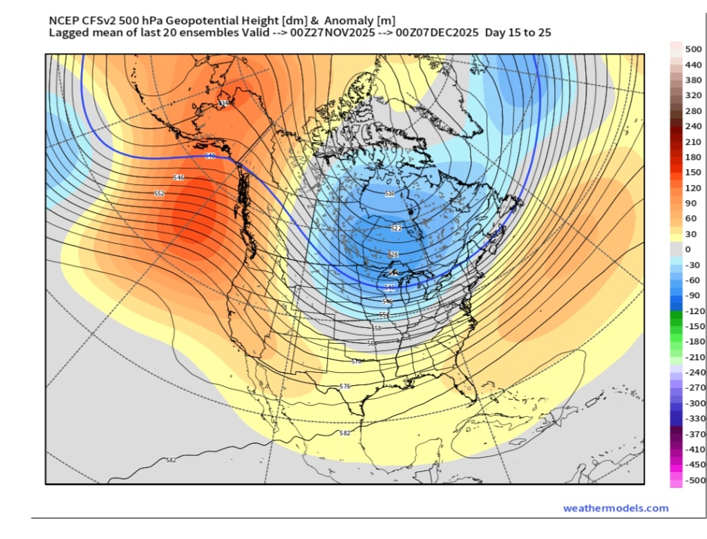
CFS Weeklies just now got on board with some cold. Has been many stepping for several runs. NOV 27-DEC 7

-
Last night in Raleigh:
-
 There were two reports of trees down on e LI in the Local Storm Reports. Below shows the stronger ECMWF Wind gust tool easily prevailed over all other model guidance. 661 NOUS41 KOKX 120225 PNSOKX CTZ005>012-NJZ002-004-006-103>108-NYZ067>075-078>081-176>179-121425- Public Information Statement National Weather Service New York NY 925 PM EST Tue Nov 11 2025 ...HIGHEST WIND GUST REPORTS... Location Speed Time/Date Provider ...Connecticut... ...Fairfield County... St Lukes School 45 MPH 0417 PM 11/11 MESOWEST Bridgeport Airport 40 MPH 1058 AM 11/11 ASOS ...New Haven County... Bethany 47 MPH 0142 PM 11/11 CWOP Stony Creek 46 MPH 0155 PM 11/11 CWOP Lighthouse Point 45 MPH 1211 PM 11/11 WXFLOW New Haven Airport 40 MPH 0416 PM 11/11 ASOS ...New London County... Groton Airport 43 MPH 0340 PM 11/11 ASOS ...New Jersey... ...Bergen County... Teterboro Airport 43 MPH 0335 PM 11/11 ASOS ...Essex County... Caldwell 41 MPH 0156 PM 11/11 ASOS ...Union County... Newark Airport 45 MPH 0151 PM 11/11 ASOS ...New York... ...Kings County... South Slope 43 MPH 1056 AM 11/11 CWOP Brooklyn College 43 MPH 0400 PM 11/11 NYSM ...Nassau County... Bayville 53 MPH 0206 PM 11/11 WXFLOW Wantagh 41 MPH 0135 PM 11/11 NYSM MASSAPEQUA 40 MPH 1113 AM 11/11 CWOP Merrick 40 MPH 0255 PM 11/11 CWOP ...New York (Manhattan) County... Midtown Manhattan 45 MPH 0320 PM 11/11 NYSM Central Park 40 MPH 0204 PM 11/11 ASOS ...Orange County... Montgomery Airport 44 MPH 0406 PM 11/11 AWOS ...Queens County... NYC/La Guardia 48 MPH 0156 PM 11/11 ASOS Kew Garden Hills 47 MPH 0405 PM 11/11 NYSM NYC/JFK Airport 46 MPH 1155 AM 11/11 ASOS Breezy Point 40 MPH 1206 PM 11/11 WXFLOW ...Richmond County... College of Staten Island 44 MPH 0140 PM 11/11 NYSM 2 SE Elizabeth 43 MPH 0148 PM 11/11 NDBC ...Rockland County... Suffern 45 MPH 0400 PM 11/11 NYSM ...Suffolk County... Eatons Neck 61 MPH 0238 PM 11/11 WXFLOW Baiting Hollow 60 MPH 0319 PM 11/11 CWOP Islip Airport 59 MPH 0253 PM 11/11 ASOS Great Gull Island 54 MPH 0138 PM 11/11 WXFLOW Brookhaven 52 MPH 0315 PM 11/11 CWOP Farmingdale Airport 51 MPH 0219 PM 11/11 ASOS Southold 50 MPH 0305 PM 11/11 CWOP Shirley Airport 48 MPH 0316 PM 11/11 ASOS Westhampton Airport 48 MPH 0343 PM 11/11 ASOS Montauk Airport 47 MPH 1207 PM 11/11 ASOS Orient 46 MPH 0245 PM 11/11 CWOP Shoreham 46 MPH 0315 PM 11/11 DAVIS Ridge 46 MPH 0322 PM 11/11 CWOP Fishers Island Airport 44 MPH 0340 PM 11/11 WXFLOW West Gilgo Beach 42 MPH 0105 PM 11/11 CWOP Fire Island CG 42 MPH 0145 PM 11/11 WXFLOW Mecox Bay 42 MPH 0343 PM 11/11 WXFLOW Stony Brook 40 MPH 1040 AM 11/11 NYSM Stony Brook 40 MPH 0303 PM 11/11 CWOP ...Westchester County... White Plains Airport 53 MPH 0220 PM 11/11 ASOS ...Maritime Stations... ...Connecticut... Stongington Outer Breakwater 51 MPH 0222 PM 11/11 WXFLOW 1 ESE Norwalk 44 MPH 1127 AM 11/11 WXFLOW ...New Jersey... Jersey City 50 MPH 1158 AM 11/11 CWOP ...New York... 15 S Atlantic Beach 51 MPH 0350 PM 11/11 NDBC 26 SSE Robert Moses State Pa 49 MPH 0300 PM 11/11 NDBC Manhattan Dwntwn 49 MPH 0926 AM 11/11 AWOS Robbins Reef, NJ 48 MPH 1112 AM 11/11 NOS-PORTS Fire Island CG 46 MPH 0151 PM 11/11 WXFLOW Shinnecock 46 MPH 0335 PM 11/11 WXFLOW Point O Woods YC 45 MPH 1242 PM 11/11 WXFLOW Northport 43 MPH 0225 PM 11/11 DAVIS Kings Point 43 MPH 0418 PM 11/11 NOS-NWLON Larchmont Harbor 40 MPH 0112 PM 11/11 WXFLOW &&
 -
29.3/27.3 with -SN and 25° wind chill. Lovely morning. Living the dream.
-

November 2025 general discussions and probable topic derailings ...
Bryan63 replied to Typhoon Tip's topic in New England
Have a work trip to Portland next week with two employees flying in from LA and Phoenix, hoping they get to see some flakes while they're out. -
Was perfect timing as well. Early evening, perfectly clear skies, and the moon didn't rise until almost midnight.
-

November 2025 general discussions and probable topic derailings ...
Cold Miser replied to Typhoon Tip's topic in New England
Stay extremely safe. -
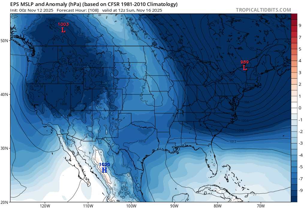
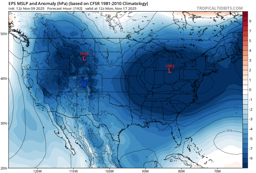
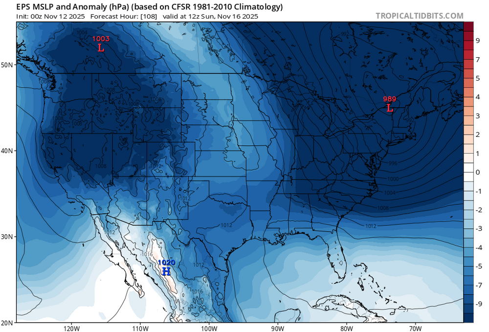
We recently got the big wave break from the record low east of Newfoundland. This feature wasn’t showing up near the start of November. So the much stronger blocking lead to the pattern this week being cooler than originally forecast. But what hasn’t changed is the very fast Pacific flow. This leads to the persistent cutter, hugger, snd suppressed Southern stream storm tracks. A few days ago the models were hinting at a transfer going south of Long Island. Now the storm has shifted north with a warmer track. Another recurring feature has been a trough to our west during storm time which is continuing. So going into December I am more interested in what happens with the storm track rather than what kind of temperature departures the long range models are showing. Since as we saw last winter, if the storm tracks are warm even in a slightly colder overall pattern it will lead to below average snowfall. But we have plenty of time to see how things go once we get into the beginning of December. Weekend low shifted further north New run Old run
-

Central PA Fall Discussions and Obs
Jns2183 replied to ChescoWx's topic in Upstate New York/Pennsylvania
It would be amazing to get a 3"-6" Thanksgiving feast Sent from my SM-G970U1 using Tapatalk -
Caribbean missiles meant for boats landing in Russia?
-
Will we lose the grid today?
-
I think it was October 24. That was the real show. Then there was one in May 6 months earlier. Sounded like around 11:30 it really popped off, but I was asleep.
- Today
-
Aurora was visible without a camera last night. With 2-3 second exposure great pictures. Skies were pretty clear at 1130
-

November 2025 general discussions and probable topic derailings ...
CoastalWx replied to Typhoon Tip's topic in New England
Nothing really exciting ahead. -
November 2025 general discussions and probable topic derailings ...
CoastalWx replied to Typhoon Tip's topic in New England
Yeah 2003 was insane. I still remember the traffic jam it caused. I had no idea until I looked up from my car and was like wtf!! -
 Light snow falling
 -
Low of 36. No second freeze
-
I’ll text my kid. She’s at ODU. If she saw snow she’ll tell me