All Activity
- Past hour
-

First Winter Storm to kickoff 2025-26 Winter season
bristolri_wx replied to Baroclinic Zone's topic in New England
Not going great, but a little early to give up on it. I would at least wait until Monday morning. Unless you are referring to something else... -
6” mean on the EPS for MBY!?!
-
Nov 28-30th Post Turkey Day Winter Storm
A-L-E-K replied to Chicago Storm's topic in Lakes/Ohio Valley
Enjoying this weenie band -
DMAC98 started following November Banter 2025
-
I like how you changed the arc of your line just in time to keep it just north of stephens city. Lol
-
Nov 28-30th Post Turkey Day Winter Storm
KeenerWx replied to Chicago Storm's topic in Lakes/Ohio Valley
Just crossed 5”. Still stacking, so 8” should be within reach. Pure bliss outside. -

First Winter Storm to kickoff 2025-26 Winter season
40/70 Benchmark replied to Baroclinic Zone's topic in New England
The whole thing has gone to crap. -

December 2025 regional war/obs/disco thread
weathafella replied to Torch Tiger's topic in New England
Yeah we just drove to Evanston. I think 8-10 is a good bet with the long duration of the event. We’ll be having dinner in town Monday night for my birthday with maybe 1-3 inches expected from the next system. -

First Winter Storm to kickoff 2025-26 Winter season
WxWatcher007 replied to Baroclinic Zone's topic in New England
Totally agree with the threats. That’s all we can ask for, and last year while it sticks in our memory has no real bearing on what’ll happen this season. I’m cautious on snow amounts to begin with in my first calls but I still think it’s a light to moderate event for most of CT. Either way, we quickly turn the page to the Arctic hounds Friday and a possible system next weekend. -

Nov 28-30th Post Turkey Day Winter Storm
cyclone77 replied to Chicago Storm's topic in Lakes/Ohio Valley
7 inches on the nose here as of about 1:45. Flake size has increased with these little enhanced blobs moving overhead from time to time. -
i would guess at this time it's yonkers and north for accumulating snow, possibly even northern Bronx may get on some action if it falls during the night as the storm intensifies and pulls out
-

First Winter Storm to kickoff 2025-26 Winter season
ineedsnow replied to Baroclinic Zone's topic in New England
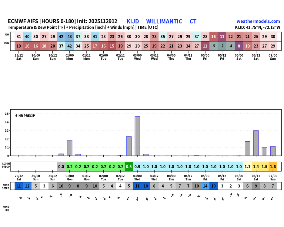
Tuesday Snow, mainly after 10am. High near 32. Calm wind becoming southeast around 6 mph in the afternoon. Chance of precipitation is 80%. New snow accumulation of 3 to 5 inches possible. Tuesday Night Snow likely, mainly before 11pm. Mostly cloudy, with a low around 19. North wind 6 to 8 mph. Chance of precipitation is 70%. -
House is decorated inside and out. Snowboard in the yard. Just need snow.
-
(002).thumb.png.6e3d9d46bca5fe41aab7a74871dd8af8.png)
Central PA Fall Discussions and Obs
ChescoWx replied to ChescoWx's topic in Upstate New York/Pennsylvania
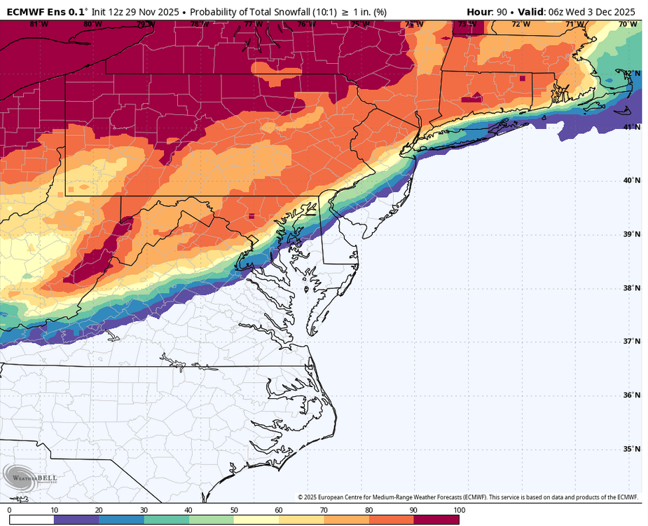
European ensemble snow greater than 1 inch probability has increased a bit at 12z with the 50% line down to Philly -
The way to a cold rain
-
(002).thumb.png.6e3d9d46bca5fe41aab7a74871dd8af8.png)
E PA/NJ/DE Autumn 2025 Obs/Discussion
ChescoWx replied to PhiEaglesfan712's topic in Philadelphia Region
European ensemble snow greater than 1 inch probability has increased a bit at 12z with the 50% line down to Philly -

Nov 28-30th Post Turkey Day Winter Storm
Kaner88 replied to Chicago Storm's topic in Lakes/Ohio Valley
Averaging 5.75" here just north of ORD... if the HRRR is to be trusted there's another ~7" or so left to come from now onwards -

First Winter Storm to kickoff 2025-26 Winter season
Ginx snewx replied to Baroclinic Zone's topic in New England
-
These seem to be the 2 potential windows to watch via recent guidance- I still like the 10-11th, but the 6th is starting to look intriguing, with some potential for significant southern energy to eject northeastward from the SW, and a nice NA look. A lot of NS energy associated with the TPV lobe though as advertised, and we know how that goes with timing(phasing vs crushing).
-

Nov 28-30th Post Turkey Day Winter Storm
Chicago Storm replied to Chicago Storm's topic in Lakes/Ohio Valley
METAR KORD 291951Z 13011KT 1/4SM R10L/2600V3000FT +SN FZFG VV007 M02/M03 A3011 RMK AO2 SLP205 SNINCR 1/5 P0005 T10221033 $ -
This is the way
-

First Winter Storm to kickoff 2025-26 Winter season
Ginx snewx replied to Baroclinic Zone's topic in New England
-

First Winter Storm to kickoff 2025-26 Winter season
Sey-Mour Snow replied to Baroclinic Zone's topic in New England
No doubt about last year underperforming we ended up getting like 5-10” in 2 week from the 18-24” mean that we had. But this does mean that the threats are there. Im leaning white rain to rain up to I-84 / coating to 2” 84 corridor / 2-5” highest hills NW for now. -
Nov 28-30th Post Turkey Day Winter Storm
Chicago916 replied to Chicago Storm's topic in Lakes/Ohio Valley
In Mequon and it's mod-heavy snow with decent sized dendrites. Definitely getting heavier and windier.


