All Activity
- Past hour
-
The monthly snowfall composites back that up
-
The weighted analog mean produces the follow snowfall predictions BWI: 18.1" IAD: 18.3" DCA: 14" December and January average below normal temps. February much above normal. My current snowfall forecast is slightly above this but I simply added a small bump for the "we're due" index. We've been pretty unlucky lately, maybe we get one good hit and this is that rare nina that ends up slightly above normal snowfall. They do happen once in a while and we are due for one. But for what it's worth the composite mean beat my "gut" adjustments 3 of the last 4 years. So... My call BWI: 20" IAD: 23" DCA: 15"
-
November 2025 general discussions and probable topic derailings ...
dryslot replied to Typhoon Tip's topic in New England
Expect the same, Some snow showers going on now here. -

November 2025 general discussions and probable topic derailings ...
jbenedet replied to Typhoon Tip's topic in New England
I have roses, daisies, pansies and Lilly’s still budding. Lawn is still lush green. Being at a local max altitude in downtown — my thinking is —this makes for a very specific phenomenon, as the rad cold sinks down the hill to the Cocheco River adjacent and to the heart of down town below. If we can avoid good radiational conditions over the week, could be around through thanksgiving. -

November 2025 general discussions and probable topic derailings ...
Hoth replied to Typhoon Tip's topic in New England
The Pats kicking ass is a good augury for winter. We had a lot of great winters during their dynastic period and winters have sucked since Tom left. Some day the Pats’ win record may go hand in hand with beehive height and squirrel obesity as great winter predictors. -
The good news is that GEFS/GEPS have kind of been destroying the EPS the last 4-6 winters for the most part with the post D10 evolutions involving the pattern due to them seeming to handle PAC issues better. Both of those show markedly faster transitions for those in the E in late Nov than the EPS which is going much more -PNA and SE ridge.
-
Yea thats a little weird.
-

November 2025 general discussions and probable topic derailings ...
tamarack replied to Typhoon Tip's topic in New England
Models are squabbling and marginal temps. Unless the Euro and GFS get some resemblance, we might still be seeing absurd ranges this time tomorrow. -
Day four of snow here. 32.0°
-
November 2025 general discussions and probable topic derailings ...
dryslot replied to Typhoon Tip's topic in New England
He's the real deal, Love the Uni's too. -
Records: Highs: EWR: 73 (1993) NYC; 72 (1993) LGA: 72 (1993) JFK: 68 (2005) Lows: EWR: 21 (1986) NYC: 20 (1905) LGA: 24 (1986) JFK: 24 (2019) Historical: 1842: Mild conditions in the Midwest were misleading as a major change to colder conditions was coming. Within 36 hours, the Mississippi River at Galena, IL completely froze over and navigation would not be possible on the river there for over 5 months; not until April 15th of the following year. (Ref. Wilson Wx. History) 1914: Atlanta, Georgia: The day's HIGH temperature of 28 degrees marks their earliest daily high below the freezing mark in Atlanta (Ref. WxDoctor) 1920 It was 19 °F in Washington, DC the earliest minimum temperature in history less than 20° at WBO. (Ref. The Washington Weather Records - KDCA) 1921: During the afternoon hours, thunderstorms brought severe hail to portions of Alabama. The hailstones ranged from about the size of buckshot to as large as a baseball. The largest stoned weighed as much as a pound. 1959: Canadian high pressure brought extremely early season winter cold to parts of the Plains and Great Lakes. Sioux Falls, SD & Sioux City, IA tied their November record for the coldest for so early in the season with -17° and -9° respectively. Valentine, NE set a November record low with -22°. Rapid City, SD not only set their low temperature record for November but their coldest for so early in the season with -19°. Other daily record lows included: Huron, SD: -18°, Aberdeen, SD: -15°, International Falls, MN: -14°, Norfolk, NE: -12°: Tied, Duluth, MN: -3°: Tied, Des Moines, IA: -1°, Madison, WI: 2°, Rockford, IL: 4°, Milwaukee, WI: 7°. (Ref. Wilson Wx. History) 1964: With the help of a fresh three-inch cover of snow, the temperature at Ely, NV dipped to 15 degrees below zero to establish an all-time record low for the month of November. That record of -15 degrees was later equaled on the 19th of November in 1985. (The Weather Channel) 1964 - With the help of a fresh three inch cover of snow, the temperature at Ely, NV, dipped to 15 degrees below zero to establish an all-time record low for the month of November. That record of -15 degrees was later equalled on the 19th of November in 1985. (The Weather Channel) 1969: Apollo 12 was launched into a threatening gray sky with ominous cumulus clouds. Pete Conrad's words 43 seconds after liftoff, electrified everyone in the Control Center: "We had a whole bunch of buses drops out," followed by "Where are we going?" and "I just lost the platform." Lightning had stricken the spacecraft. Warning lights were illuminated, and the spacecraft guidance system lost its attitude reference. Boston, Massachusetts had 12 days consecutive days with measurable precipitation from the 3rd to the 14th the longest period for November. (Ref. NOAA Boston Weather Events) 1972: Heavy snow fell in parts of New England as a major coastal storm moved up the coast. 18 inches of wet snow fell in Vermont and New Hampshire. Power lines toppled and communication was disrupted. (Ref. AccWeather Weather History) 1974 - A storm produced 15 inches of snow at the Buffalo, NY, airport, and 30 inches on the south shore of Lake Erie. (David Ludlum) 1986 - An early season cold wave set more than 200 records from the northwestern U.S. to the east coast over a seven day period. For some places it proved to be the coldest weather of the winter season. (Sandra and TI Richard Sanders - 1987) 1987 - The first major snowstorm of the season hit the Southern and Central Rockies, producing 12 inches at the Brian Head ski resort in Utah overnight. Strong and gusty winds associated with the storm reached 52 mph at Ruidoso NM. In the eastern U.S., the temperature at Washington D.C. soared to 68 degrees, just three days after being buried under more than a foot of snow. (The National Weather Summary) (Storm Data) 1988 - A massive storm produced snow and gusty winds in the western U.S., with heavy snow in some of the higher elevations. Winds gusted to 66 mph at Show Low AZ, and Donner Summit, located in the Sierra Nevada Range of California, was buried under 23 inches of snow. Heavy rain soaked parts of California, with 3.19 inches reported at Blue Canyon. (The National Weather Summary) (Storm Data) 1989 - Unseasonably warm weather prevailed east of the Rockies. Temperatures reached 70 degrees as far north as New England, and readings in the 80s were reported across the southeast quarter of the nation. Nineteen cities reported record high temperatures for the date. For the second time in the month Dallas/Fort Worth TX equalled their record for November with an afternoon high of 89 degrees. The high of 91 degrees at Waco TX was their warmest of record for so late in the season. Heavy snow blanketed parts of Wyoming overnight, with a foot of snow reported at Cody, and ten inches at Yellowstone Park. (The National Weather Summary) (Storm Data) 1993: A ridge along the east coast provided unseasonably warm weather across the East. Locations reporting record high temperatures for the date included: Charleston, WV: 85° (broke previous record by 10 degrees), Augusta, GA: 85°, New Orleans, LA: 84°, Huntington, WV: 82°, Wilmington, NC: 82°, Roanoke, VA: 82°, Charleston, SC: 82°, Bristol, TN: 81°, Richmond, VA: 81°, Norfolk, VA: 80°-Tied, Elkins, WV: 79°, Beckley, WV: 78°, Lynchburg, VA: 78°, Salisbury, MD: 77°. (Ref. Wilson Wx. History) 1995: An early season snowstorm dropped 20-30 inches of snow in parts of Maryland, West Virginia, Pennsylvania and New York. Some totals included 32 inches at Somerset County, PA, 28 inches at Garrett County, MD, and 21 inches at Coudersport, PA. (Ref. AccWeather Weather History) 1999: For the 8th straight day, record high temperatures were set across a large area of the nation. Over 300 record daily highs were set during the week, including over 3 dozen new records for November. Daily record highs included: Palm Springs, CA: 92°, Phoenix, AZ: 91°, Tucson, AZ: 90°, Raleigh, NC: 81°-Tied, Oklahoma City, OK: 80°, Lynchburg, VA: 79°, Asheville, NC: 76°, Great Falls, MT: 71°, Cheyenne, WY: 71°, Billings, MT: 70°, Cut Bank, MT: 68°, Casper, WY: 68°-Tied, Burns, OR: 66°. (Ref. AccWeather Weather History) 2005: A winter storm spread of heavy snow across parts of the Rockies; especially in Colorado where some areas picked up over a foot. Some totals included: Aspen Springs: 14 inches and near Nederland: 12 inches. Part of I-70 was closed for a time due to blowing and drifting. Winds gusted over 60 mph in some areas. Some gusts included: Sugarloaf Mountain west of Boulder: 91 mph, Georgetown: 89 mph and at the Denver International Airport: 61 mph. (Ref. Wilson Wx. History)
-
Ok... There is going to be a warm up for Thanksgiving.... But, it is brief and then things tumble. And it looks like we head into a pretty good Winter pattern after. So, yes.... You are correct about the Thanks giving warm up! (But I'm sure you won't be sad that it will be short lived and Winter will start to.make.its way into our region soon after).
-

November 2025 general discussions and probable topic derailings ...
Ginx snewx replied to Typhoon Tip's topic in New England
In love with him and the uniforms. Keep him healthy and you have a perennial MVP candidate. The shoulder logo is sick -
The storm tracks last winter which were favored because of the Pacific jet helped Cape May and places south of there. You could see over and over again how the fast flow knocked down western ridges and sent endless kicker shortwaves that interfered with any phasing or amplification. We need the western ridge or some kind of mechanism to amplify the flow and bring the storm up the coast.
-
49 / 30 sunshine. FInally a mostly cloudy forecast hasnt verified yet today. Overall near to slightly above normal through the 18th before turning much warmer the 19th - 26th perhaps beyond with ridging into the east , potentially strong ridging. Back to colder as we close the month and open next.
-
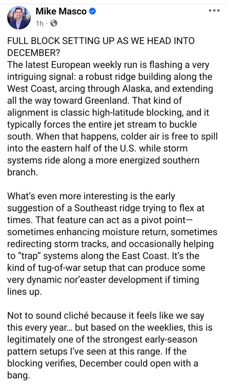
An “energized southern branch” (STJ) in a La Niña with a -PMM? Huh?
-
I think the dry is going to remain stubborn until next spring-ish. And if we get a wet winter month it’s probably going to be mild overall. Just the nature of La Niña.
-

November 2025 general discussions and probable topic derailings ...
dendrite replied to Typhoon Tip's topic in New England
-
I ran the composites using my weighted full analog method. It didn't really change the outcome much. December through mid January still looks pretty good. February looks brutal. Is what it is. Definitely not a non winter look though. Winter Mean Dec Jan Feb
-
-
Impressive cold early next week?
-

November 2025 general discussions and probable topic derailings ...
MJO812 replied to Typhoon Tip's topic in New England
Hopefully the moose takes cover -
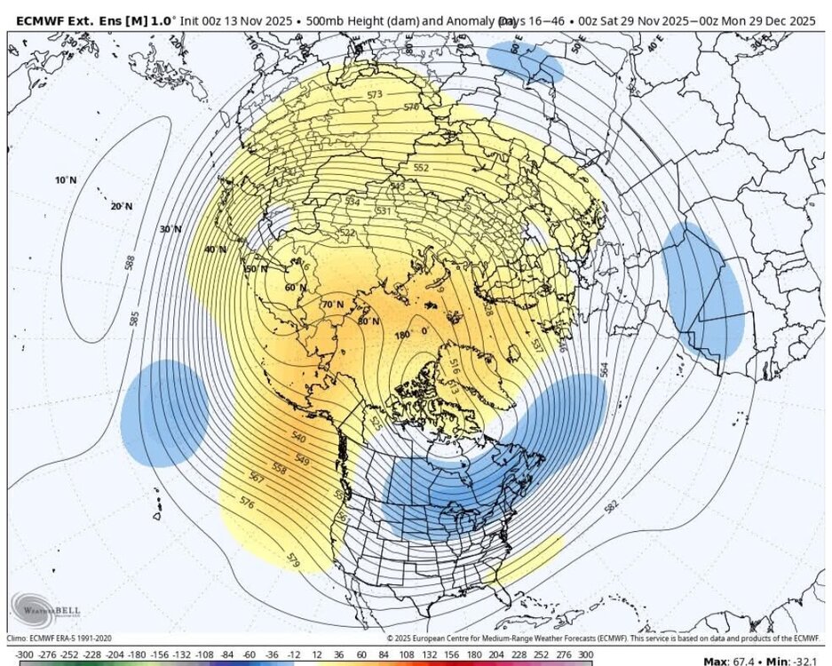
The 0z GEPS and 12z GEFS are frigid at the ends of their runs today. The EPS is lagging as it kicked the can by about 3-5 days yesterday. It still "should" get there, but have to be careful for the Charlie Brown football deal. When ensembles get that cold, chances start to go way up. Those ensembles are cold for about 75% o NA and almost all of the Lower 48. Pretty impressive.


